
 A 50-cm Vivid Terrain DSM collected over Oahu, Hawaii, USA.
An Exciting Product Update Here!! First off, this product name has changed to Vivid Terrain but everything else remains the same as the original Precision 3D offering; well everything other than the minimum order which is now just 100 square kilometers – a massive decrease from the original minimum order!
In conjunction with our partner, Vantor, we are pleased to offer 50-cm Vivid Terrain (formerly called Precision 3D or P3D) digital elevation models (DEMs) from a growing archive that already covers over 80% of the global land mass. Produced exclusively by Vantor from their vast archive of mono satellite imagery, they are able to create 50-centimeter (cm) resolution digital elevation models (DEMs) with impressive spatial accuracy.
Vivid Terrain replaces the need for stereo pairs by combining a multitude of high-resolution satellite images taken at varying look angles along with a 3D modeling algorithm to create their extremely detailed and accurate elevation models. Vivid Terrain DEMs are offered at a variety of resolutions as both a digital surface model (DSM) or a digital terrain model (DTM).
 A DTM of the Colorado Front Range on the left side of the image above blends into a Vivid Terrain 3D Surface Model over Golden, Colorado, USA.
Here is a summary of the current Vivid Terrain DEM specifications:
DEM Post Spacing (i.e. Resolution): 50-cm (core product offering)
Absolute Vertical Accuracy: < 3 m Linear Error 90% (LE90)
Absolute Horizontal Accuracy: < 3 m Circular Error 90% (CE90)
Product Levels: DSM and DTM
Average Delivery Time: 2 – 3 weeks, where available
Thanks to Vantor’s vast archive, they are able to create custom DEMs of almost any place in the world – adding massive blocks to the Vivid Terrain archive monthly.
You can search for Vivid Terrain DEM coverage 24-hours a day by using Image Hunter. If you have any pricing requests, additional questions or would like a new price list with Vivid Terrain DEM data added in, send us an email at sales@apollomapping.com!
In this monthly feature, we span the globe to examine Our Changing Landscape with a time series of medium-resolution PlanetScope satellite imagery. The PlanetScope constellation dates back to 2016 and collects hundreds of millions of square kilometers of four and eight-band 3-meter imagery daily! In December, we visited the Bay of Fundy in Canada. For the January edition of this series, we are looking at the September 2025 floods in Ayod, Sudan.
The PlanetScope Microsat Constellation
PlanetScope is a constellation of more than 240 microsats referred to individually as Doves. Each Dove is able to collect up to 20,000 square kilometers (sq km) per day of 3-meter (m) 4-band multispectral (i.e. blue, green, red and near-infrared [NIR]) imagery; and newly launched SuperDoves collect 8-band multispectral adding in valuable red-edge spectral data. Across the constellation, PlanetScope is archiving more than 200 million sq km of medium-resolution imagery a day, making it the go to source for daily imagery over most locations. This massive archive dates back to 2016, offering the most complete and continuous record of spatial data on the planet since the start of the constellation’s ongoing launch schedule. Collecting 3-meter multispectral imagery is the equivalent of ‘high-resolution’ multispectral data imaged by a 75-centimer (cm) satellite (as this satellite would feature 75-cm panchromatic and 3-m multispectral), making PlanetScope an extremely competitively priced option at just $2.25 per sq km. With well registered images and nearly daily collections of most locations, PlanetScope is the ideal imagery source for this current-events focused series, Our Changing Landscape.
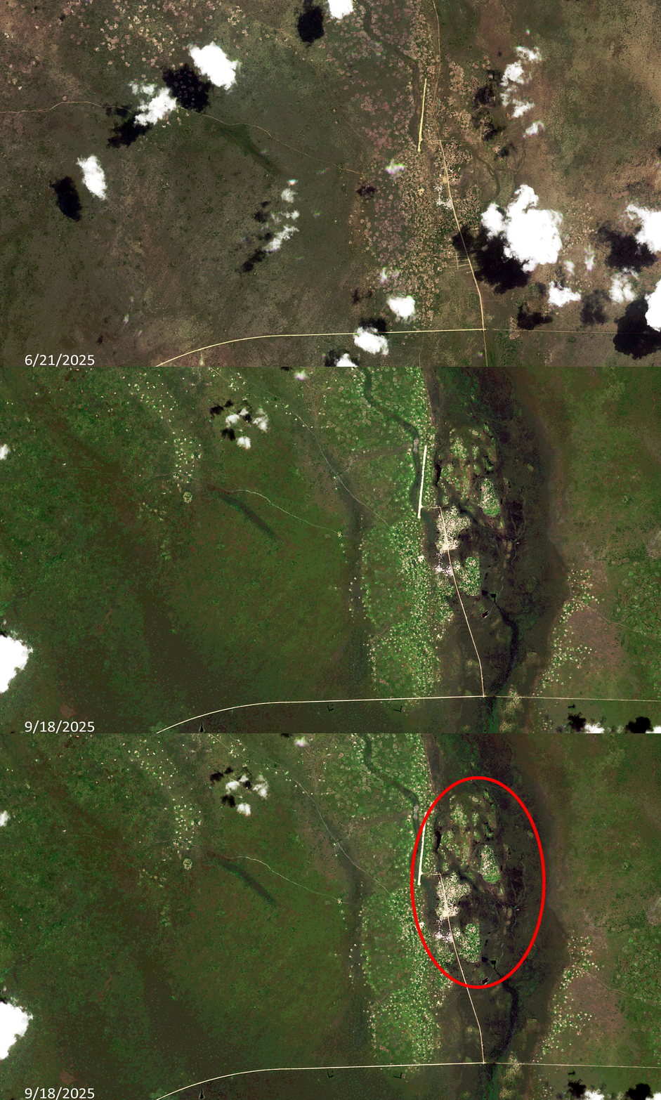 Click on the image above to see an animation of 3-meter natural color PlanetScope image collected over Ayod, Sudan on June 21 and September 18, 2025. In this animation, you can see how brown the landscape is and how low the rivers and canal that runs through the center are in June. Then in the September 18th image, you can see the rains have brought major flooding to the canal and Nile River tributaries in the central part of the image – further, the rains have revived lush, green plant life in the surrounding region. (Images Courtesy: © Planet 2026)
September 2025 Flooding Of Ayod, Sudan
The summer of 2025 started out with below average rainfall during the rainy season in the Blue Nile Basin. By early August, rainfall began to slowly increase, but experts who looked ahead anticipated a considerable increase in rainfall from late August through the end of September. Sudden flooding struck Sudanese states along the Nile basin in the second half of September, sparking a sharp rise in the water level of the Blue Nile – a tributary of the Nile River.
According to Atar, as part of a complex global ecological system, Sudan’s rainfall patterns are heavily influenced by the Indian Ocean, which drives seasonal monsoon winds toward the Ethiopian Highlands. The rainfall over the highlands largely depends on sea surface temperatures in the Indian Ocean, which trigger the Indian monsoon depression – a system that increases evaporation of moisture-laden air that moves northwestward. As this air mass reaches the highlands and cools, it condenses and results in rain.
This year, however, climate anomalies disrupted that pattern. The warming of the Indian Ocean, which typically begins in June, was delayed. Consequently, the rainy season in northern Ethiopia, particularly over the Tekezé Basin (Atbara River), also started late, well after June and July, leading to an eventual heavy surge in river flow.
Later, the Blue Nile Basin, which is the primary tributary feeding both the Grand Ethiopian Renaissance Dam (GERD) reservoir and the Blue Nile itself, saw intense rainfall from August through mid-September, followed by a gradual decline. These fluctuations can be described as natural climatic variability within the regional rain cycle. However, the GERD introduced a new variable into the dynamics of Nile flow. The natural flow of the river is no longer the sole determinant of water availability downstream in Sudan.
Instead of releasing a significant portion of the stored water from previous years in anticipation of new inflows during the 2025 rainy season, Ethiopia withheld large volumes. This was likely due to uncertainty about 2025 rainfall, especially after June and July experienced below-average precipitation, prompting fears that Ethiopia might lose part of its annual share if it allowed too much water to flow downstream to Sudan and Egypt, both of which insist on maintaining their historical annual quotas (18.5 billion cubic meters for Sudan, and 55.5 billion for Egypt, as per the 1959 Nile Waters Agreement).
In mid-September, just days after Ethiopia’s GERD inauguration festival on September 9th, residents of Blue Nile State in southeastern Sudan saw a rapid rise in river levels. The river soon overflowed into Ad-Damazin, Ar-Roseires, and other villages, prompting waves of emergency calls and social media images documenting the floods. Yet it was only a full week later, on September 22nd that Sudan’s Ministry of Irrigation and Water Resources issued its first official advisory on the rising water levels. Water levels continued to rise until September 29th.
On September 8th, severe flooding displaced about 50,000 people in Ayod County leaving many without food, shelter, or medical care, local officials said.
If you would like to find out more about using 3-meter PlanetScope imagery for your academic studies, engineering projects or any landscape analysis, let us know at sales@apollomapping.com or (303) 993-3863.

We love maps.
We love imagery.
We love work breaks.
We hope you like them as well!
In 2023, the Denver Nuggets prevailed and won the NBA Championship. Their hometown held a celebration parade for the team, which can be seen in the 50-cm WorldView image shown here. Hundreds of thousands of fans flocked to Civic Center Park to catch a glimpse of the team and celebrate with them. Paradegoer Doug Garcia, of Wheat Ridge, told the Colorado Sun that he’d been waiting for that special day since 1976, the year he was born and the year the Nuggets joined the league.
The parade ended with a victory rally outside Civic Center to celebrate the history-making championship, their first in the team’s 47-year existence. A two-hour parade kicked off at 9AM outside Union Station, as kids danced in the fountain while their parents watched, decked out in jerseys, championship tees and chains. Denver’s mayor at the time, Michael Hancock, estimated the crowd at 700,000 to 1 million people.
For this month’s Imagery Work Break, we feature a WorldView-2 50-cm color enhanced photo from June 15, 2023. It was taken over Civic Center Park in Denver, Colorado where you can see a mass of people in the park, watching the Denver Nuggets celebration parade.
Have a great rest of your workday! 😊
(Image Courtesy: Maxar. Processed by Apollo Mapping for improved color accuracy and clarity.)
¡Bienvenidos a enero! Nosotros en Apollo Mapping estamos gustosos de tenerlos otro mes aquí en los resúmenes españoles del mes de enero.
PRODUCTO DESTACADO – DEMs Vivid Terrain de Vantor de 50 cm – ¡Nuevo tamaño mínimo de pedido!
Un DSM Vivid Terrain de 50 cm recolectado sobre Oahu, Hawái, Estados Unidos.¡Tenemos una emocionante actualización de producto! En primer lugar, este producto ha cambiado de nombre a Vivid Terrain, pero todo lo demás se mantiene igual que la oferta original Precision 3D, excepto el pedido mínimo, que ahora es de solo 100 kilómetros cuadrados, una reducción enorme frente al pedido mínimo original.
En conjunto con nuestro socio Vantor, nos complace ofrecer modelos digitales de elevación (DEM) Vivid Terrain de 50 cm, anteriormente conocidos como Precisión 3D o P3D, provenientes de un archivo en constante crecimiento que ya cubre más del 80% de la masa terrestre global. Producidos exclusivamente por Vantor a partir de su amplio archivo de imágenes satelitales mono, estos modelos permiten crear DEMs de 50 centímetros de resolución con una precisión espacial impresionante.
Vivid Terrain elimina la necesidad de pares estereoscópicos al combinar una gran cantidad de imágenes satelitales de alta resolución tomadas desde distintos ángulos de observación junto con un algoritmo de modelado 3D para crear modelos de elevación extremadamente detallados y precisos. Los DEMs Vivid Terrain se ofrecen en una variedad de resoluciones como modelo digital de superficie (DSM) o modelo digital del terreno (DTM).
Un DTM de la región Front Range de Colorado, en el lado izquierdo de la imagen, se integra con un modelo de superficie 3D Vivid Terrain sobre Golden, Colorado, Estados Unidos.
A continuación, se presenta un resumen de las especificaciones actuales de los DEMs Vivid Terrain:
Espaciamiento de postes del DEM (resolución): 50 cm (producto principal)
Precisión vertical absoluta: < 3 m Error Lineal 90% (LE90)
Precisión horizontal absoluta: < 3 m Error Circular 90% (CE90)
Niveles de producto: DSM y DTM
Tiempo promedio de entrega: 2–3 semanas, cuando esté disponible
Gracias al extenso archivo de Vantor, es posible crear DEMs personalizados de casi cualquier lugar del mundo, agregando grandes bloques de datos al archivo Vivid Terrain cada mes.
Puedes buscar cobertura de DEMs Vivid Terrain las 24 horas del día utilizando Cazador de Imágenes. Si tienes solicitudes de precios, preguntas adicionales o deseas una nueva lista de precios que incluya datos DEM Vivid Terrain, envíanos un correo electrónico a sales@apollomapping.com.
Colecciones de Imágenes de Alta Resolución – Pléiades 1 – Australia, junio a agosto de 2025
 Este mapa muestra las áreas capturadas por la constelación Pléiades 1 entre junio hasta agosto 31 de 2025 sobre Australia. En muchos casos, se recopilaron múltiples imágenes sobre la misma área, lo cual resulta difícil de representar en un mapa estático.
En esta publicación mensual, ofrecemos a nuestros lectores una visión general de la cobertura de imágenes de alta resolución recopilada sobre una geografía específica durante un período determinado. Para ello, seleccionamos una constelación de satélites de alta resolución, un período de tiempo definido y un área de interés, y luego reportamos estadísticas clave sobre la cantidad total de imágenes recopiladas en kilómetros cuadrados (km²). Sin más demora, pasemos a nuestro análisis.
Región Gráfica de Interés: Australia más islas
Superficie Terrestre Cubierta: 7,692,024.0 km²
Período de Tiempo: 1 de junio al 31 de agosto de 2025
Constelación de Satélites de Alta Resolución: Pléiades 1A/1B
Estadísticas de imágenes de la constelación Pléiades 1 – Australia
Área total recopilada: 380,280.3 km²; 2,066.7 km² por satélite / por día
Área recopilada con menos del 20% de nubosidad y una inclinación de 30° o menos fuera del nadir: 296,363.8 km²; 1,610.7 km² por satélite / por día; 77.93% del total
Nuestro Paisaje Cambiante – Inundaciones en Ayod, Sudán
Haz clic en la imagen de arriba para ver una animación de imágenes PlanetScope de color natural de 3 metros, recopiladas sobre Ayod, Sudán, el 21 de junio y el 18 de septiembre de 2025. En esta animación, se puede observar cuán marrón es el paisaje y cuán bajos están los ríos y el canal que atraviesa el centro en junio. Luego, en la imagen del 18 de septiembre, se aprecia cómo las lluvias han provocado importantes inundaciones en el canal y en los afluentes del río Nilo en la parte central de la imagen; además, las lluvias han revitalizado una exuberante vegetación verde en la región circundante. (Imágenes cortesía: © Planet 2026)
En esta sección mensual, recorremos el mundo para examinar Nuestro Paisaje Cambiante mediante una serie temporal de imágenes satelitales PlanetScope de resolución media. La constelación PlanetScope se remonta a 2016 y recopila diariamente cientos de millones de kilómetros cuadrados de imágenes de 3 metros, tanto de cuatro como de ocho bandas. En diciembre, visitamos la bahía de Fundy en Canadá. Para la edición de enero de esta serie, analizamos las inundaciones de septiembre de 2025 en Ayod, Sudán.
La constelación de microsatélites PlanetScope
PlanetScope es una constelación de más de 240 microsatélites, conocidos individualmente como Doves. Cada Dove es capaz de recopilar hasta 20,000 kilómetros cuadrados (km²) por día de imágenes multiespectrales de 3 metros (m) y 4 bandas (es decir, azul, verde, rojo e infrarrojo cercano [NIR]); y los SuperDoves lanzados más recientemente recopilan imágenes multiespectrales de 8 bandas, incorporando valiosa información espectral del borde rojo. En conjunto, PlanetScope archiva más de 200 millones de km² de imágenes de resolución media cada día, lo que lo convierte en la fuente de referencia para imágenes diarias en la mayoría de las ubicaciones. Este enorme archivo se remonta a 2016 y ofrece el registro espacial más completo y continuo del planeta desde el inicio del calendario de lanzamientos continuos de la constelación. La recopilación de imágenes multiespectrales de 3 metros equivale a datos multiespectrales de “alta resolución” capturados por un satélite de 75 centímetros (cm), ya que dicho satélite contaría con 75 cm pancromáticos y 3 m multiespectrales, lo que convierte a PlanetScope en una opción extremadamente competitiva en precio, a solo $2.25 por km². Con imágenes bien registradas y adquisiciones casi diarias en la mayoría de las ubicaciones, PlanetScope es la fuente de imágenes ideal para esta serie centrada en eventos actuales, Nuestro Paisaje Cambiante.
Inundaciones de septiembre de 2025 en Ayod, Sudán
El verano de 2025 comenzó con precipitaciones por debajo del promedio durante la temporada de lluvias en la cuenca del Nilo Azul. A principios de agosto, las lluvias comenzaron a aumentar lentamente, pero los expertos anticipaban un incremento considerable de las precipitaciones desde finales de agosto hasta finales de septiembre. Inundaciones repentinas afectaron a los estados sudaneses a lo largo de la cuenca del Nilo en la segunda mitad de septiembre, provocando un fuerte aumento del nivel del agua del Nilo Azul, un afluente del río Nilo.
Según Atar, como parte de un complejo sistema ecológico global, los patrones de precipitación de Sudán están fuertemente influenciados por el océano Índico, que impulsa los vientos monzónicos estacionales hacia las tierras altas de Etiopía. Las lluvias sobre estas tierras altas dependen en gran medida de las temperaturas de la superficie del mar en el océano Índico, que activan la depresión del monzón indio, un sistema que incrementa la evaporación del aire cargado de humedad que se desplaza hacia el noroeste. Cuando esta masa de aire alcanza las tierras altas y se enfría, se condensa y produce lluvias.
Sin embargo, este año, las anomalías climáticas interrumpieron ese patrón. El calentamiento del océano Índico, que normalmente comienza en junio, se retrasó. En consecuencia, la temporada de lluvias en el norte de Etiopía, particularmente sobre la cuenca del Tekeze (río Atbara), también comenzó tarde, bien entrados junio y julio, lo que derivó finalmente en un fuerte aumento del caudal de los ríos.
Posteriormente, la cuenca del Nilo Azul, que es el principal afluente que alimenta tanto el embalse de la Gran Presa del Renacimiento Etíope (GERD) como al propio Nilo Azul, registró precipitaciones intensas desde agosto hasta mediados de septiembre, seguidas de una disminución gradual. Estas fluctuaciones pueden describirse como una variabilidad climática natural dentro del ciclo regional de lluvias. Sin embargo, la GERD introdujo una nueva variable en la dinámica del caudal del Nilo. El flujo natural del río ya no es el único factor determinante de la disponibilidad de agua aguas abajo en Sudán.
En lugar de liberar una porción significativa del agua almacenada de años anteriores en anticipación a nuevos aportes durante la temporada de lluvias de 2025, Etiopía retuvo grandes volúmenes. Esto probablemente se debió a la incertidumbre sobre las precipitaciones de 2025, especialmente después de que junio y julio registraron lluvias por debajo del promedio, lo que generó temores de que Etiopía pudiera perder parte de su cuota anual si permitía que demasiada agua fluyera río abajo hacia Sudán y Egipto, ambos países firmes en mantener sus cuotas históricas anuales (18.5 mil millones de metros cúbicos para Sudán y 55.5 mil millones para Egipto, según el Acuerdo de las Aguas del Nilo de 1959).
A mediados de septiembre, apenas unos días después del festival de inauguración de la GERD en Etiopía el 9 de septiembre, los residentes del estado del Nilo Azul, en el sureste de Sudán, observaron un rápido aumento de los niveles del río. Pronto, el río se desbordó hacia Ad-Damazin, Ar-Roseires y otras aldeas, lo que provocó oleadas de llamadas de emergencia e imágenes en redes sociales que documentaban las inundaciones. Sin embargo, no fue sino hasta una semana completa después, el 22 de septiembre, que el Ministerio de Irrigación y Recursos Hídricos de Sudán emitió su primer aviso oficial sobre el aumento de los niveles del agua. Los niveles continuaron incrementándose hasta el 29 de septiembre.
El 8 de septiembre, inundaciones severas desplazaron a unas 50,000 personas en el condado de Ayod, dejando a muchas sin alimentos, refugio ni atención médica, según informaron funcionarios locales.
Si deseas obtener más información sobre el uso de imágenes PlanetScope de 3 metros para estudios académicos, proyectos de ingeniería o cualquier análisis del paisaje, contáctanos en sales@apollomapping.com o al (303) 993-3863.
Fernando Gutierrez
Topographic Translator
I’m still a few years off from 50, but alongside aches and pains, I’ve accumulated something else as I’ve aged – friends in their 70s, otherwise known as septuagenarians. Now, none of these friendships started when they were in their 70s, but my point is that I have a lot of friends who are 25-30 years older than me, more so that I have 25-30 years younger. I don’t think that’s a bad thing, but I’m trying to figure out how to sit with it and how it came to be so.
All of these friends but one are colleagues, either from the university I work at or my field of study. The one who isn’t was a former neighbor and he was a soon-to-be retired college professor when I met him. They say most relationships start at work – only I didn’t get the romantic kind, just the father/mother figure kind. Again, not a bad thing. Just trying to work through it. And yes, some of my older friends are female, and one is a lesbian. She and I get along like peanut butter and jelly and she’s one of the few people I know who has a fouler mouth than me. Boy, she loves to f-ing cuss!
Some of these friendships are mostly propped up by email, as a couple of the guys live on the other side of the country. Sadly, I’ve only seen each of them once a piece in the last five years and I don’t know when it’s realistic to expect to see them again. I’ve kind of come to terms with the likelihood that I may never see them again. I’m not exactly alright with that, but I don’t know if the stars will come back into alignment. While I was rambling around the west this past summer I had full intention – or at least hoped – to see them both, but it just didn’t work out. While I was down in SW CO, I was eyeing getting down to Santa Fe, NM, to see one, but it’s almost a 4-hour drive and my window was too tight. The other is up in Bellingham, WA, but spends time in Hood River, OR, and I was driving into Portland from the Rockies about the time he was to be at his cabin. But as luck would have it, the day I was to pass through he had to head back north to attend to some business. Opportunity missed.
 My future older-self wondering where all my younger friends are. (Image retrieved from here and comes courtesy of Pixabay.)
Another is down in Athens, GA, and I’ve seen him somewhat regularly the past three years, staying with him most times I go down there to see music. We have the most regular communication of those not rooted to my adoptive hometown in some way, frequently texting and emailing one another. My other female septuagenarian friend I’ve known the longest, about two years before I started my doctorate. When I was looking at programs, knowing I wanted to study music fandom, I stumbled across her edited collection on Deadheads. Another friend encouraged me to email her, and I did. We chatted by phone and it was a great exchange. Small world that it is we live in, I ended up working at the same university as her, and to make that world even smaller, we share the same suite even though we’re in different departments. You can’t make this stuff up.
My former department chair is someone I count as a friend as well. Now retired, he and I meet up for beers 3-4 times a year. Another colleague from the social work department, also retired, I met in the first few months of starting my job. My dean said that he and I would be fast friends, describing him as a “crazy man.” We met and did indeed become fast friends. We hung around a lot for several years, but ever since he became a grandpa 4x over, I see him far less often.
This brings me to my former neighbor, the septuagenarian friend I see the most. It’s not unusual for me to see him once a week and he’s often watched my dog. When he moved out of his house and was staying with his ex-wife in an apartment while he looked for something more suitable, he practiced his drums at my house for at least a year. He’s very well-read with an amazing mind for history and social analysis, though the latter is skewed because of his political leanings as a self-professed communist. He’s borderline bat-shit crazy, too, and I’ve seen him at his highest and lowest moments, and sometimes those come within minutes of one another. He undoubtedly has some undiagnosed mental illnesses, but he’s one of the most interesting people I know. I would’ve liked to know him in his 20s, he must’ve been a hellraiser…
I have friends that span the age spectrum. The youngest I count as a friend (i.e., someone who I would go get a beer with, might call up randomly and have it not be weird, and can be mostly honest with) is 27. The oldest in the group is 79. This certainly does allow me to get different perspectives and understand what matters – and what doesn’t – to people in different stages of life. When I think back to my younger self 20-25 years ago, I often wonder if he would’ve gotten along with my current self. Now I think about my current self in relation to my future self 25 years down the road.
Having older friends allows me a glimpse into what’s ahead, and I think that will be wildly beneficial, even if nothing currently sticks out as a remarkable insight or life lesson at this point, in terms of what I’ve gathered from my septuagenarian cohort. I do wonder what they think of having a much-younger friend, though, as only two of the seven have any other younger friends that I’m aware of (perhaps unsurprisingly, those are the two deeply invested in the local music scene). In general, do they feel younger when they hang out or converse with me? Does doing so allow them to connect to their pasts in ways they otherwise might not be able to?
It’s kind of weird that I have so many septuagenarian friends in a way, as I honestly don’t feel I treat them any different than my same-age or younger friends; they’re just people. But when I interact with my parents (slightly older, in their early 80s), they seem like dinosaurs to me. Maybe that’s why I find it odd – it’s so easy to be myself with my older friends, and more challenging to do so with my (older) parents. I guess there’s probably something there in the relationships I have with my septuagenarians that in some way what I wish I had in my relationship with my parents. (Kind of.) But I also wonder if having friends in their 70s helps me to understand my parents better or appreciate them more. Maybe. I’ll have to give that some more thought. If nothing else, it gives me more opportunities to notice the subtle changes that occur more frequently as we age, and that may pay off in terms of following my parents’ health arc more closely.
My final thought on having all these older friends, much as with my older parents, is that they’re not going to live forever. Eventually, their health will decline. Eventually, they will die. When that downward trajectory begins, what will be my role in their lives as a friend? What will I learn from them as their lives come to an end? How will that affect me going forward?
Before too long, I’ll be in my 70s (god willing), and I wonder if I’ll have good friends 25 years younger. I hope so. I just wonder if what I get from them at the point will be anything like what I give to my older friends now. Time will tell; I guess…
Marco Esquandoles
Time Traveler
If you are searching for medium and high-resolution satellite imagery, the search is over as Image Hunter is the solution you’ve been looking for! Featuring satellite and aerial imagery as well as digital elevation models (DEMs) from a constantly expanding list of 60+ constellations/datasets and 19 vendors, our database contains more than 500-million images/records meaning there is just no other website out there with this breadth of commercial data products. Our interface is slim-lined and modern, loading quickly on all platforms, browsers and operating systems. Further, our database is updated multiple times an hour with the most recent images collected by WorldView-3, Pléiades 1, PlanetScope, SuperView-1 and many more so you are sure to get the most current view of all the imagery and DEM databases we work with. Once you submit your request, an Apollo Mapping representative will be in touch within 4 Illinois business hours to get you the pricing information you need for your project.
So why wait? Give Image Hunter a try now to find the imagery and/or DEM data you need for your next mapping project!
Key Improvement(s) From The Past Month
We’ve been hinting at it’s release for a few months now, and it is time to officially announce our latest tool addition to Image Hunter, and that is a clip polygon to image tool! Yes, you read that correct, you can now clip any area of interest (AOI) to a list of image dates and receive the area covered by each image, woot woot! You can even export this list as a spreadsheet, or you can copy and paste the list into an email with a button push. This is just the first release of our new clip polygon to image tool, and we have big plans for it coming soon as well. We’d love to hear your feedback on features you would like added to our new clip polygon to image tool, email it over to us anytime at sales@apollomapping.com.
Here is a summary of the changes/improvements we made to Image Hunter during the past month:
- Our first version of the clip polygon to image tool is live!
- PlanetScope previews now load in the Review/Save interface.
- Searches for PlanetScope data were acting up, they are all fixed up now.

Data Alert – An Automated Daily Imagery Search
Have you checked out Data Alert which lets you define an area of interest anywhere around the globe, the resolution your project requires and the number of months we should keep the alert active? Once an alert is set up, we check for new data over your area of interest every single day, and send you an email when we find coverage that meets your specifications. We have a short YouTube video with directions to set up a Data Alert, check out the last video; and we have written directions for Data Alert here.
The Sensors Available in Image Hunter
As you might have seen in past articles, we now feature hourly updates (seriously!) of GeoEye-1, KOMPSAT 3/3A, Pléiades 1 and Neo, SPOT 6/7, SuperView-1/2/Neo, WorldView-1/2/3/Legion!
Image Hunter can be accessed 24 hours a day, 7 days a week and is a one-stop shop for every major source of medium and high-resolution satellite (and aerial!) imagery on the market today, including:
- WorldView Legion
- WorldView-4
- WorldView-3
- WorldView-2
- WorldView-1
- QuickBird
- GeoEye-1
- IKONOS
- EROS B
- KOMPSAT-3A
- KOMPSAT-3
- KOMPSAT-2
- Pléiades 1 constellation
- Pléiades Neo constellation
- TerraSAR-X (TerraSAR-X, TanDEM-X and PAZ)
- GEOSAT-1
- GEOSAT-2
- TripleSat
- BJ3A
- BJ3N
- SPOT 1 to 7 constellation
- RapidEye
- GaoFen-2
- GaoFen-1
- ZiYuan-3 01/02 (mono and stereo!)
- FORMOSAT-5
- FORMOSAT-2
- ALOS PRISM (stereo)
- AW3D Standard (DEM)
- SkySat constellation
- PlanetScope constellation (including 5-band SuperDove data)
- SuperView-1 constellation
- SuperView-2
- SuperView Neo-1 01/02
- SuperView Neo-3
- Landsat 1-8
- TeLEOS-1
- DS-EO
- Hexagon (HxGN Content Program aerial imagery) imagery + DEM
- WorldDEM
- WorldDEM Neo
- Vricon DEMs
- Orbita Hyperspectral Satellite (OHS)
- KazEOSat-1
- KazEOSat-2
- Jilin-1 Optical
- Jilin-1 Video (including nighttime imagery)
- Jilin-1 GF/DP
- Jillin-1 KF
- Orbita Video Satellites-1/2/3 (OVS-1/2/3)
- BlackSky Global series
Key Features of Image Hunter
If any of our readers have struggled with other geospatial search engines that are clunky, only query one data source and/or do not provide image previews, then Image Hunter is the solution to your woes as it features:
- Online browsing of satellite and aerial imagery from 19 data providers and 56 satellite and aerial imagery derived datasets.
- Near-instantaneous loading of low-resolution preview imagery with collection date, cloud cover and other key metadata.
- The ability to define your area of interest by address, coordinates, geometric shape or shapefile/KMZ.
- A responsive basemap with street names to provide spatial context when discovering data as well as crowd-sourced updates for the most accurate map possible.
- Exports of the area of interest you create as well as the scenes you select in shapefile or KMZ format.
- Support for all operating systems, and not just our friends with Windows machines!
Image Hunter can be accessed here all day and night, we are excited to find out what you think about our imagery search engine! So if you have any ideas and/or feedback to improve Image Hunter, please let us know at sales@apollomapping.com or (303) 993-3863.

Cricket’s Chirp is created for Apollo Mapping by Ron Ruelle, a Northwest Ohio (formerly Boulder, CO) based cartoonist, lllustrator and teacher. No animals are harmed in the creation of these comics, but Ron sometimes breaks a pencil in frustration. He has a new collection of his weekly Skelton Comics available at www.ronruelle.com
In December, we looked at Serra de Leba Pass in Angola, which is one of the famous hair-pinned roads in the world. This month for the Pléiades 1 – Pléiades Neo Point of Interest, we check out Banwol Island in South Korea.
About the Point of Interest: Banwol Island, also known as Purple Island for good reason, sits near Bakji Island off the south-western coast of South Korea. The island, which also goes by Half Moon Island, features 400 purple-roofed buildings, purple telephone boxes, and large lavender fields. Inspired by the traditional cultivation of bellflowers and kohlrabi, this transformation began in 2015 with a goal of attracting more visitors with its creatively carved out photo zones and a sculpture dedicated to the K-pop group BTS, whose members’ phrase, “I purple you,” is closely associated with the color.

 These two satellite images show Banwol Island in South Korea, surrounded by water but with its hundreds of homes adorned with purple roofs dotting the island and the purple bridge stretching across the waves to the next island. You can clearly see these features in the color 50-cm Pléiades 1A image from February 5, 2023; as well as in the 30-cm Pléiades Neo 4 image taken May 13, 2024 where the hue of purple rooves really pops. These images have custom processing and color balancing applied by Apollo Mapping. PLEIADES © CNES 2026, Distribution Airbus DS.
Fun Factoids: (1) Banwol Island historically depended on fishing and agriculture, with both deep-sea and marsh fishing practiced. (2) As part of the rebrand, the residents took on the chore of planting of 21,500 meters of lavender fields, as well as fields of Aster daisies, lily magnolia, lilac, hollyhock, and purpletop vervain. (3) Since the initial revitalization efforts in 2018, more than 490,000 visitors had come to the island as of 2021. (4) Banwol Island is connected to Bakji Island and to Anjwa Island by a large, two-section wooden pedestrian bridge called the “Purple Bridge” due to its color. (5) Even the hard-boiled eggs on top of bibimbap (Korean mixed rice dish) are purple and there’s purple sweet potato ice cream. (6) And finally, of course visitors can rent a purple bike to explore what the island has to offer!
The 50-cm Pléiades 1 High-Resolution Satellite Constellation
The Pléiades 1 constellation (or at least part of it!) has been in orbit since December 2011 and if you have not had a chance to check out any sample imagery, take a few moments and have a look at the gallery on our website. If you work with high-resolution imagery, you should consider Pléiades 1 and Pléiades Neo for your next geospatial projects.
A variety of Pléiades 1 products are available from both a well-established archive and as a new collection, including 50-centimeter (cm) pansharpened imagery and 50-cm panchromatic – 2-meter (m) 4-band multispectral bundles. We are happy to discuss the technical specifications, pricing and tasking options available with both of these satellite constellations.
The 30-cm Pléiades Neo High-Resolution Satellite Constellation
Pléiades Neo is our newest high-resolution satellite constellation. The first Neo satellite went up in April 2021 and the second in August of the same year. This 30-centimeter resolution constellation will add two more satellites in the next few months and upgrade from daily to intraday revisits. Pléiades Neo has six multispectral bands with 1.2-meter resolution, including a deep blue and two infrared bands, along with a 30-centimeter resolution panchromatic band.
The archive is growing every day, and the satellites are available for new collections, making Pléiades Neo the perfect solution for site monitoring. Check out our beautiful sample images in the Pléiades Neo gallery.
More sample images and technical information about Pléiades 1 can be found on our website here; while the same can be found here for the Pléiades Neo constellation.
The Apollo Mapping sales team can answer any questions you might have about Pléiades 1 and/or Pléiades Neo. We can be reached at (303) 993-3863 or sales@apollomapping.com.