
In this monthly feature, we span the globe to examine Our Changing Landscape with a time series of medium-resolution PlanetScope satellite imagery. The PlanetScope constellation dates back to 2016 and collects hundreds of millions of square kilometers of four and eight-band 3-meter imagery daily! In November, we headed to the Port of Los Angeles, the busiest container port in North America. For the December edition of this series, we are checking out tidal swings in the Bay of Fundy, Canada.
The PlanetScope Microsat Constellation
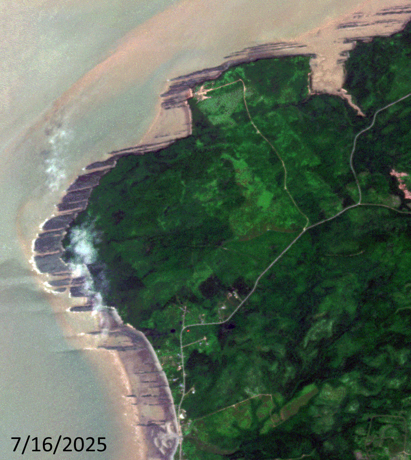
Click on the image above to see an animation of 3-meter natural color PlanetScope image collected over a coastal area on the Bay of Fundy close to Lower Cover, Nova Scotia on July 16 and August 9, 2025. And really just wow nature, as the animation highlights. In the two images you can see that the coastline on the July 16th image goes right up to the edge of the vegetation and then in the August 9th image, tens of meters of coastline have been exposed. Most of us have seen tides in action during our life, but few have likely seen something this drastic in person! (Images Courtesy: © Planet 2025)
PlanetScope is a constellation of more than 240 microsats referred to individually as Doves. Each Dove is able to collect up to 20,000 square kilometers (sq km) per day of 3-meter (m) 4-band multispectral (i.e. blue, green, red and near-infrared [NIR]) imagery; and newly launched SuperDoves collect 8-band multispectral adding in valuable red-edge spectral data. Across the constellation, PlanetScope is archiving more than 200 million sq km of medium-resolution imagery a day, making it the go to source for daily imagery over most locations. This massive archive dates back to 2016, offering the most complete and continuous record of spatial data on the planet since the start of the constellation’s ongoing launch schedule. Collecting 3-meter multispectral imagery is the equivalent of ‘high-resolution’ multispectral data imaged by a 75-centimer (cm) satellite (as this satellite would feature 75-cm panchromatic and 3-m multispectral), making PlanetScope an extremely competitively priced option at just $2.25 per sq km. With well registered images and nearly daily collections of most locations, PlanetScope is the ideal imagery source for this current-events focused series, Our Changing Landscape.
Extreme Tidal Change in the Bay of Fundy, Canada
The Bay of Fundy along Fundy National Park on New Brunswick’s east coast highlights one of nature’s most impressive shows. Twice daily, the most dramatic tides in the world cover the ocean bed with as much as 48 feet every day when 100 billion tons of seawater crash into the shore – the height of a four-story building.
Within six hours, the water slides back to expose the sea bottom that’s mucky, covered with seaweed and blooming with intertidal wildlife. The waterside beach opens up into miles of sand that, according to National Geographic, is great for picnicking. In fact, a special event called the Rising Tide Festival, held in mid-August, brings Maritime musicians inspired by the land into Fundy National Park.
During low tide, visitors can see the iconic Hopewell Rocks, also known as Flowerpot Rocks. They’re sea stacks that rise up from the tide-influenced seabed. There’s a low tide exploration path, a Big Cove panorama route and a Daniels Flats observing path for viewing the special formations. One of the most fun and exciting ways to experience the Bay of Fundy tides – which is found only in Nova Scotia, according to Nova Scotia’s official website, is riding the tidal bore on a tidal bore rafting adventure. When the Bay of Fundy’s incoming tide meets the Shubenacadie River, an abrupt change in the river current turns the calm water into a washing machine of waves. The rolling waves led by the lead wave, the tidal bore, can range from 8 to 20 feet high and creates the perfect roller coaster ride on water.
Not only is the Bay of Fundy famous for high tides, but its shoreline cliffs and beaches are home to the world’s most complete fossil record of life 300 million years ago, making it part of a UNESCO World Heritage Site and a UNESCO Global Geopark. Explore the rocky shoreline with an experienced guide such as Fundy Treasures Tours, Joggins Fossil Cliffs UNESCO World Heritage Site in Joggins or the Fundy Geological Museum in Parrsboro. There’s also a multi-course, white linen, gourmet meal hosted at Burntcoat Head Park at low tide. Guests will enjoy an intimate 3-course meal consisting of local ingredients all paired with local beer and wine.
In addition to the jaw-dropping tides, the Bay of Fundy also is home to several species of whales during the summer months, including the rare right whale. Step aboard a whale watching tour boat departing from Digby Neck, Long Island or Brier Island and head off onto the Bay of Fundy coast to look for whales.
If you would like to find out more about using 3-meter PlanetScope imagery for your academic studies, engineering projects or any landscape analysis, let us know at sales@apollomapping.com or (303) 993-3863.

Leave a Reply