
In this monthly feature, we span the globe to examine Our Changing Landscape with a time series of medium-resolution PlanetScope satellite imagery. The PlanetScope constellation dates back to 2016 and collects hundreds of millions of square kilometers of four and eight-band 3-meter imagery daily! In October, we headed to northern Chile where we checked out the Copiapo River and nearby farming town of Alianza. For the November edition of this series, we are looking at the Port of Los Angeles in the United States.
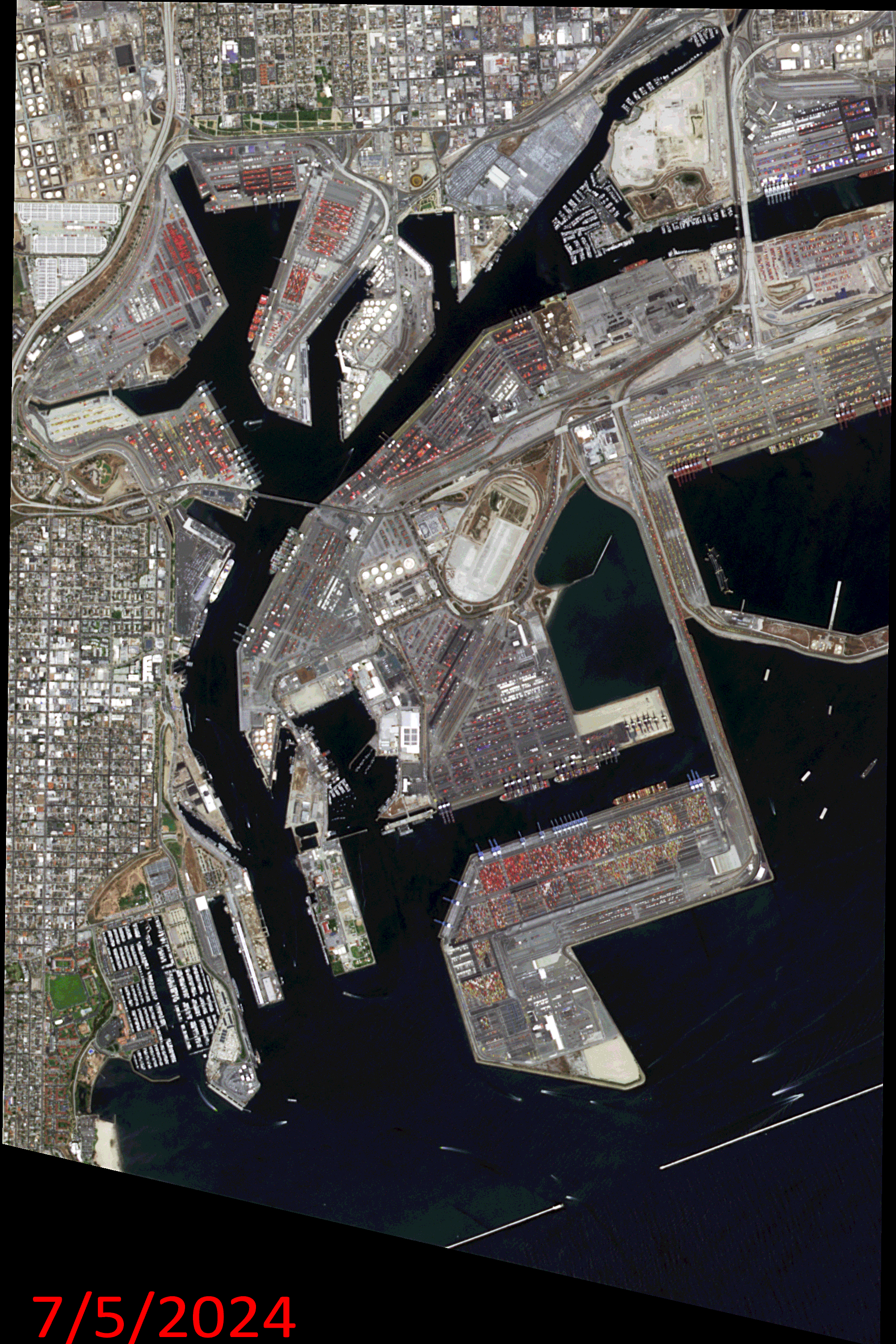
Click on the image above to see an animation of 3-meter natural color PlanetScope image collected over the Port of Los Angeles, California, USA on July 5, 2024, September 10 and November 30, 2024, and January 14, March 7, and May 7, 2025. In this animation, you can see just how much the stacks of shipping containers change over time as well as the number of huge ships in port varies from day to day. (Images Courtesy: © Planet 2025)
The PlanetScope Microsat Constellation
PlanetScope is a constellation of more than 240 microsats referred to individually as Doves. Each Dove is able to collect up to 20,000 square kilometers (sq km) per day of 3-meter (m) 4-band multispectral (i.e. blue, green, red and near-infrared [NIR]) imagery; and newly launched SuperDoves collect 8-band multispectral adding in valuable red-edge spectral data. Across the constellation, PlanetScope is archiving more than 200 million sq km of medium-resolution imagery a day, making it the go to source for daily imagery over most locations. This massive archive dates back to 2016, offering the most complete and continuous record of spatial data on the planet since the start of the constellation’s ongoing launch schedule. Collecting 3-meter multispectral imagery is the equivalent of ‘high-resolution’ multispectral data imaged by a 75-centimer (cm) satellite (as this satellite would feature 75-cm panchromatic and 3-m multispectral), making PlanetScope an extremely competitively priced option at just $2.25 per sq km. With well registered images and nearly daily collections of most locations, PlanetScope is the ideal imagery source for this current-events focused series, Our Changing Landscape.
Shipping Traffic in the Port of Los Angeles
The Port of Los Angeles happens to be the busiest container port in North America and it’s held the No. 1 spot for more than two decades with record volumes for containerized trade. The Port maintains an efficient, sustainable supply chain, adopting new technologies to improve the reliability, predictability, and efficiency of the flow of cargo across global seaborne trade.
July 2025 was the busiest month on record in the 117-year history of the Port of Los Angeles. The Port handled 1,019,837 20-Foot Equivalent Units (TEUs), 8.5% more than last July. Retailers and manufacturers brought in goods at an elevated pace due to concerns of higher tariffs later this year. Seven months into 2025, the Port of Los Angeles has handled 5,975,649 TEUs, 5% more than the same period in 2024. Furthermore, the Port of Los Angeles handled 892,340 20-Foot Equivalent Units (TEUs) in June 2025, 8% more than last year. It was the busiest June in the 117-year history of the Port of Los Angeles.
“Some importers are bringing in year-end holiday cargo now ahead of potential higher tariffs later in the year,” said Port of Los Angeles Executive Director Gene Seroka. “July may be our peak season month as retailers and manufacturers bring orders in earlier than usual, then brace for trade uncertainty. Meanwhile, the Port of Los Angeles closed its fiscal year on June 30, ending the period handling 10.5 million TEUs. That marks our third fiscal year exceeding 10 million TEUs, the only Western Hemisphere port to do so. And this time we reached that mark without a single vessel backed up.”
If you would like to find out more about using 3-meter PlanetScope imagery for your academic studies, engineering projects or any landscape analysis, let us know at sales@apollomapping.com or (303) 993-3863.

Leave a Reply