
In this monthly feature, we span the globe to examine Our Changing Landscape with a time series of medium-resolution PlanetScope satellite imagery. The PlanetScope constellation dates back to 2016 and collects hundreds of millions of square kilometers of four and eight-band 3-meter imagery daily! In September, we headed to Minnesota where we observed the Camp House Fire that broke out in May 2025 and caused extensive damage. For the October edition of this series, we are looking at the Copiapo River and nearby farming town of Alianza, Chile.
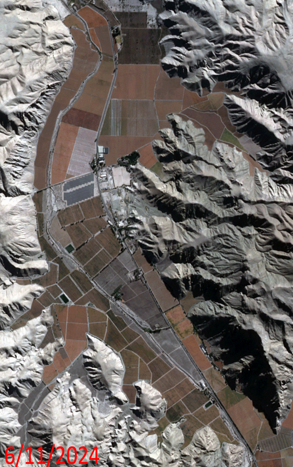 Click on the image above to see an animation of 3-meter natural color PlanetScope image collected over the Copiapo River close to Totoralillo, Chile on June 11 and July 7, 2024. In this animation, you will see how quickly agricultural fields change as many of the fields lay barren in the June image; but in the July 7th image, these same fields have been planted and crops are already emerging! (Images Courtesy: © Planet 2025)
The PlanetScope Microsat Constellation
PlanetScope is a constellation of more than 240 microsats referred to individually as Doves. Each Dove is able to collect up to 20,000 square kilometers (sq km) per day of 3-meter (m) 4-band multispectral (i.e. blue, green, red and near-infrared [NIR]) imagery; and newly launched SuperDoves collect 8-band multispectral adding in valuable red-edge spectral data. Across the constellation, PlanetScope is archiving more than 200 million sq km of medium-resolution imagery a day, making it the go to source for daily imagery over most locations. This massive archive dates back to 2016, offering the most complete and continuous record of spatial data on the planet since the start of the constellation’s ongoing launch schedule. Collecting 3-meter multispectral imagery is the equivalent of ‘high-resolution’ multispectral data imaged by a 75-centimer (cm) satellite (as this satellite would feature 75-cm panchromatic and 3-m multispectral), making PlanetScope an extremely competitively priced option at just $2.25 per sq km. With well registered images and nearly daily collections of most locations, PlanetScope is the ideal imagery source for this current-events focused series, Our Changing Landscape.
Copiapo River in Chile
The Copiapó River, located in the Atacama Desert of northern Chile, plays a crucial role in supporting agriculture in the area despite its arid environment. The river’s water proves essential for irrigating nearby crops, particularly grapes for export, in the Copiapó Valley.
The Copiapó River measures 162 kilometers long and supports the cities of Copiapó, Tierra Amarilla, and Los Loros, which are the main urban centers in the basin with a population greater than 200,000. Fruit exports, viniculture, and vegetable production are the main agricultural activities, accounting for 71% of the total water demand in the basin. On the other hand, 22% of the available water within the basin is used to mine copper, iron, gold, and silver.
However, the region faces increasing water scarcity due to factors including global climate change, mining activities, and agricultural expansion, leading to conflicts over limited water resources. Because water affects many economic, social, and environmental aspects, an interdisciplinary approach is needed to solve current and future water scarcity problems, and to minimize energy requirements in water production, researchers studying the area say.
If you would like to find out more about using 3-meter PlanetScope imagery for your academic studies, engineering projects or any landscape analysis, let us know at sales@apollomapping.com or (303) 993-3863.

Leave a Reply