
In November, we looked at Flamenco Beach on the island of Culebra Island, Puerto Rico, which features rusting, graffiti-covered tanks. This month for the Pléiades 1 – Pléiades Neo Point of Interest, we check out Serra de Leba Pass in Angola.
About the Point of Interest: Serra de Leba Pass in Angola is famous for its altitude (Mount Moco at 2,620 meters/8,600 feet is the highest mountain in Angola), for its beauty, and also for the Serra da Leba pass which climbs to 1,845 meters/6,050 feet in altitude.
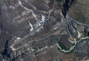
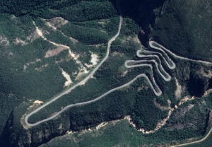 These two satellite images show the impressive mountain range known as Serra de Leba in Angola. In the first image, the windy pass road forms a serpentine shape clearly seen in the Pléiades Neo 3 30-cm color image from October 6, 2023. In the Pléiades 1A 50-cm color image taken April 29, 2023, you can see the depth and height of the mountain range as the pass road winds through it. These images have custom processing and color balancing applied by Apollo Mapping. PLEIADES © CNES 2025, Distribution Airbus DS.
 Fun Factoids: (1) The mountain range, Serra de Leba, happens to be home to one of the famous hairpinned roads in the world. (2) Legend has it that the Serra da Leba Pass is named after a Portuguese woman who designed and built the road, but died after she viewed it on the very day the project was finished. (3) Situated some 20 miles west of the city of Lubango, on the southwestern part of the country, the road is totally paved. It’s called Estrada Nacional 280. (4) Construction on this breathtaking mountain road began in the colonial era in the late 1960s and was opened in the 1970s. (5) The most challenging part of the drive is 29.7-km (18.45-mile) long, running from Renato Grade to Leba. It spirals down from the ‘plano alto’ (high plateau) elevation of 1,845 meters/6,050 feet to almost sea level in just over 10 kilometers, literally traversing 3 or 4 different climate zones during any ascent or descent. The drive is very steep, reaching a maximum gradient of 34% through some of the ramps.
The 50-cm Pléiades 1 High-Resolution Satellite Constellation
The Pléiades 1 constellation (or at least part of it!) has been in orbit since December 2011 and if you have not had a chance to check out any sample imagery, take a few moments and have a look at the gallery on our website. If you work with high-resolution imagery, you should consider Pléiades 1 and Pléiades Neo for your next geospatial projects.
A variety of Pléiades 1 products are available from both a well-established archive and as a new collection, including 50-centimeter (cm) pansharpened imagery and 50-cm panchromatic – 2-meter (m) 4-band multispectral bundles. We are happy to discuss the technical specifications, pricing and tasking options available with both of these satellite constellations.
The 30-cm Pléiades Neo High-Resolution Satellite Constellation
Pléiades Neo is our newest high-resolution satellite constellation. The first Neo satellite went up in April 2021 and the second in August of the same year. This 30-centimeter resolution constellation will add two more satellites in the next few months and upgrade from daily to intraday revisits. Pléiades Neo has six multispectral bands with 1.2-meter resolution, including a deep blue and two infrared bands, along with a 30-centimeter resolution panchromatic band.
The archive is growing every day, and the satellites are available for new collections, making Pléiades Neo the perfect solution for site monitoring. Check out our beautiful sample images in the Pléiades Neo gallery.
More sample images and technical information about Pléiades 1 can be found on our website here; while the same can be found here for the Pléiades Neo constellation.
The Apollo Mapping sales team can answer any questions you might have about Pléiades 1 and/or Pléiades Neo. We can be reached at (303) 993-3863 or sales@apollomapping.com.

Leave a Reply