
In this monthly feature, we span the globe to examine Our Changing Landscape with a time series of medium-resolution PlanetScope satellite imagery. The PlanetScope constellation dates back to 2016 and collects hundreds of millions of square kilometers of four and eight-band 3-meter imagery daily! In January, we visited Ayod, Sudan, to check out the devastating September 2025 floods. For the February edition of this series, we head down-under to watch the resurgence of Kalamurina Wildlife Sanctuary in the Outback of Australia.
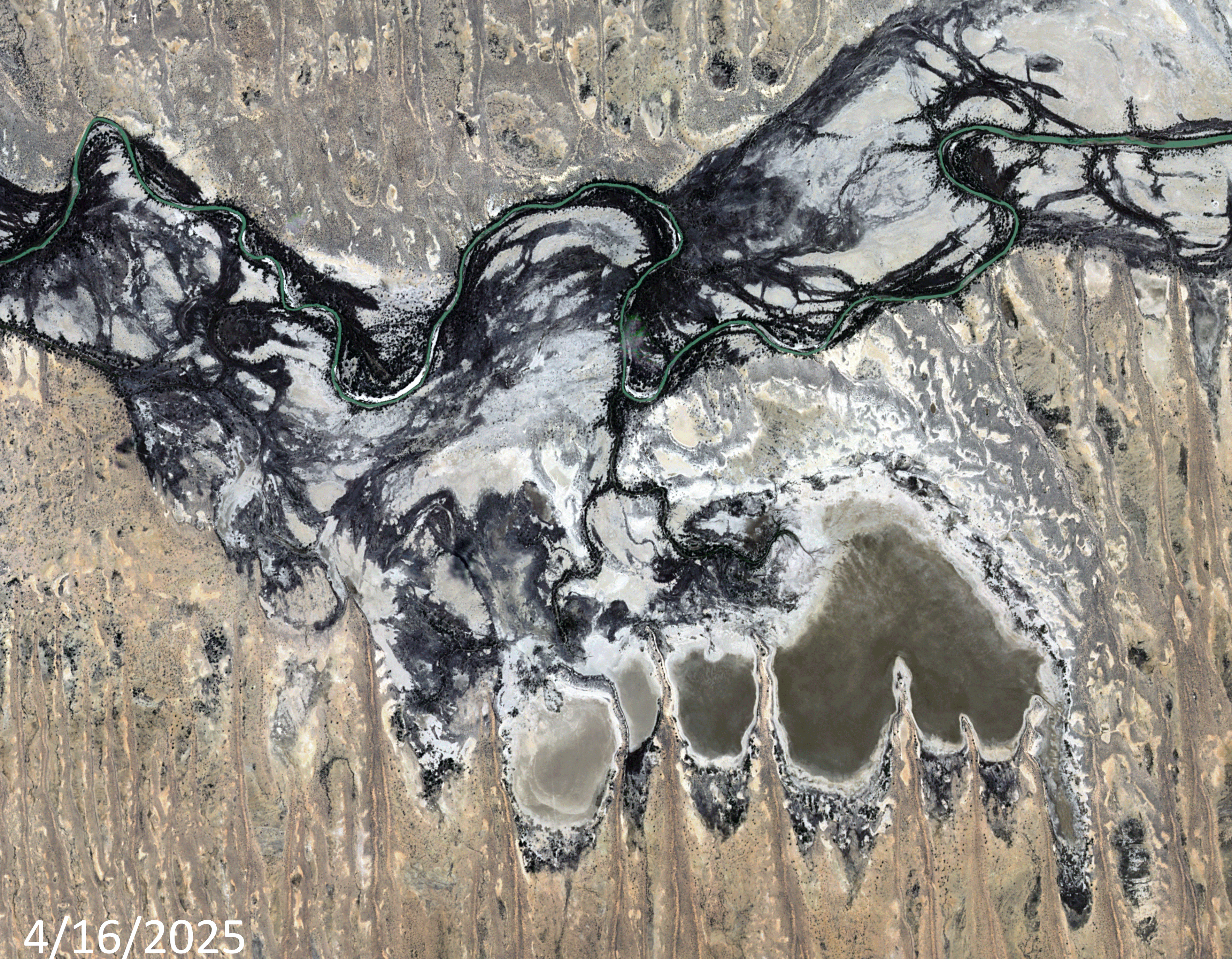 Click on the image above to see an animation of 3-meter natural color PlanetScope image collected over Kalamurina Wildlife Sanctuary on April 16, June 21, August 16, and October 19, 2025. First off, apologies for the shifted position of the June and August images – this can happen in rare cases with remote PlanetScope data. In this animation, you can see how dry and barren the landscape is in the April 16th image. By the June 21st image, the rains have started in this region and have started to fill the ephemeral ponds and rivers that flow through the sanctuary; and then in August 16th image, you can see that the ponds and rivers have already started dry up but the life-giving water they brought to this landscape have caused a huge re-birth of the vegetation here. And then finally, by the October 19th image, you can see more of the water has evaporated and the green landscape has started to dry out and thus the vegetation is drying out and desiccating. (Images Courtesy: © Planet 2026)
The PlanetScope Microsat Constellation
PlanetScope is a constellation of more than 240 microsats referred to individually as Doves. Each Dove is able to collect up to 20,000 square kilometers (sq km) per day of 3-meter (m) 4-band multispectral (i.e. blue, green, red and near-infrared [NIR]) imagery; and newly launched SuperDoves collect 8-band multispectral adding in valuable red-edge spectral data. Across the constellation, PlanetScope is archiving more than 200 million sq km of medium-resolution imagery a day, making it the go to source for daily imagery over most locations. This massive archive dates back to 2016, offering the most complete and continuous record of spatial data on the planet since the start of the constellation’s ongoing launch schedule. Collecting 3-meter multispectral imagery is the equivalent of ‘high-resolution’ multispectral data imaged by a 75-centimer (cm) satellite (as this satellite would feature 75-cm panchromatic and 3-m multispectral), making PlanetScope an extremely competitively priced option at just $2.25 per sq km. With well registered images and nearly daily collections of most locations, PlanetScope is the ideal imagery source for this current-events focused series, Our Changing Landscape.
Rebirth of Kalamurina Wildlife Sanctuary in the Outback of Australia
In June, a rare inland sea formed in Australia’s arid center, reviving the baren desert and drawing wildlife and visitors to the Outback to check out the phenomenon. Kati Thanda-Lake Eyre is a 3,668-square-mile ephemeral lake that actually only receives just 5.5 inches of rain on average per year. It could be more readily thought of as a giant salt pan in the south Australian desert due to its lack of water.
There are two main arteries feeding Lake Eyre — the Georgina-Diamantina River, which began filling Kati Thanda-Lake Eyre’s north in early May 2025, and the Cooper Creek system. Cooper Creek, named by early British explorer Charles Sturt, isn’t much of a creek despite its name, according to Accuweather.
This year, after Tropical Cyclone Alfred dumped on inland Queensland in March, the water flowing down to Kati Thanda-Lake Eyre appeared to be filling it for just the fourth time in 160 years. The lake, when filled with refreshing water, sees the desert ecosystem convert into something fully different with shrimp and crustaceans, fish, endangered animals, waterbirds and more. Even native shrubs will crop up. However, with this rebirth of the area, tourists flock to see the sharp changes. That’s had its ups and downs, though, with the South Australian government enforcing a ban on people walking on the lake bed to help protect the salt crust and surface.
Conservationists Annemarie van Doorn and Luke Playford manage the Kalamurina Wildlife Sanctuary, a 679,667-hectare property owned by the Australian Wildlife Conservancy on the eastern shore of the lake. The vastness of their world can only truly be understood from the helicopter they use to do their conservation work. The property they alone are responsible for is the size of Delaware.
“This is special because it’s a natural event,” Playford told Accuweather. “It’s the largest flood in 50 years, and while that did a lot of damage in Queensland, this is an act that’s not induced by climate change. It’s a special occasion.”
If you would like to find out more about using 3-meter PlanetScope imagery for your academic studies, engineering projects or any landscape analysis, let us know at sales@apollomapping.com or (303) 993-3863.

Leave a Reply