
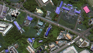
 A 50-cm color DS-EO image collected on June 13, 2025 over Muara, Brunei.
Are you seeking high-resolution images tailored for precision-focused applications within the equatorial region? Launched from India in 2022 by Geo-Insights, the 50-cm DS-EO satellite system can collect the imagery you need, and collect often. DS-EO carries an electro-optic, multi-spectral payload that provides 4-band 2-meter (m) multispectral and 50-centimeter (cm) panchromatic images for advanced spectral analysis. It can produce accurate 4-band imagery and boasts a panchromatic band wavelength range of 450 – 800 nanometers to capture broad-spectrum black and white imagery with high resolution at 50-cm.
Because of the twice daily visits, you can utilize reliable, timely DS-EO data with exceptional detail in the equatorial zone. With 16-bit depth, 50-cm panchromatic resolution, and four 2-m multispectral bands, it is possible to conduct analyses that include object identification, as well as assessments of vegetation health and water quality.
Learn more about how DS-EO offers sharp details for insightful analytics, identifying multi-faceted objects in environmental or maritime circumstances!
You can query 50-cm DS-EO data anytime on Image Hunter. And if you have any additional questions about tasking DS-EO or archive data from this satellite system, you can email us now at sales@apollomapping.com.

Leave a Reply