
In this monthly feature, we span the globe to examine Our Changing Landscape with a time series of medium-resolution PlanetScope satellite imagery. The PlanetScope constellation dates back to 2016 and collects hundreds of millions of square kilometers of four and eight-band 3-meter imagery daily! In July, we were over Vulkan Krenityna in Sakhalin Oblast, Russia. For the August edition of this series, we head to the USA to check out bluebonnets blooming in Brenham, Texas.
Do you enjoy the high-resolution satellite imagery we post monthly in this article and elsewhere in The Geospatial Times? If so, head over to our Reddit subgroup, HighResSatelliteImage, where we will post some our favorite high-resolution satellite images on a weekly basis.
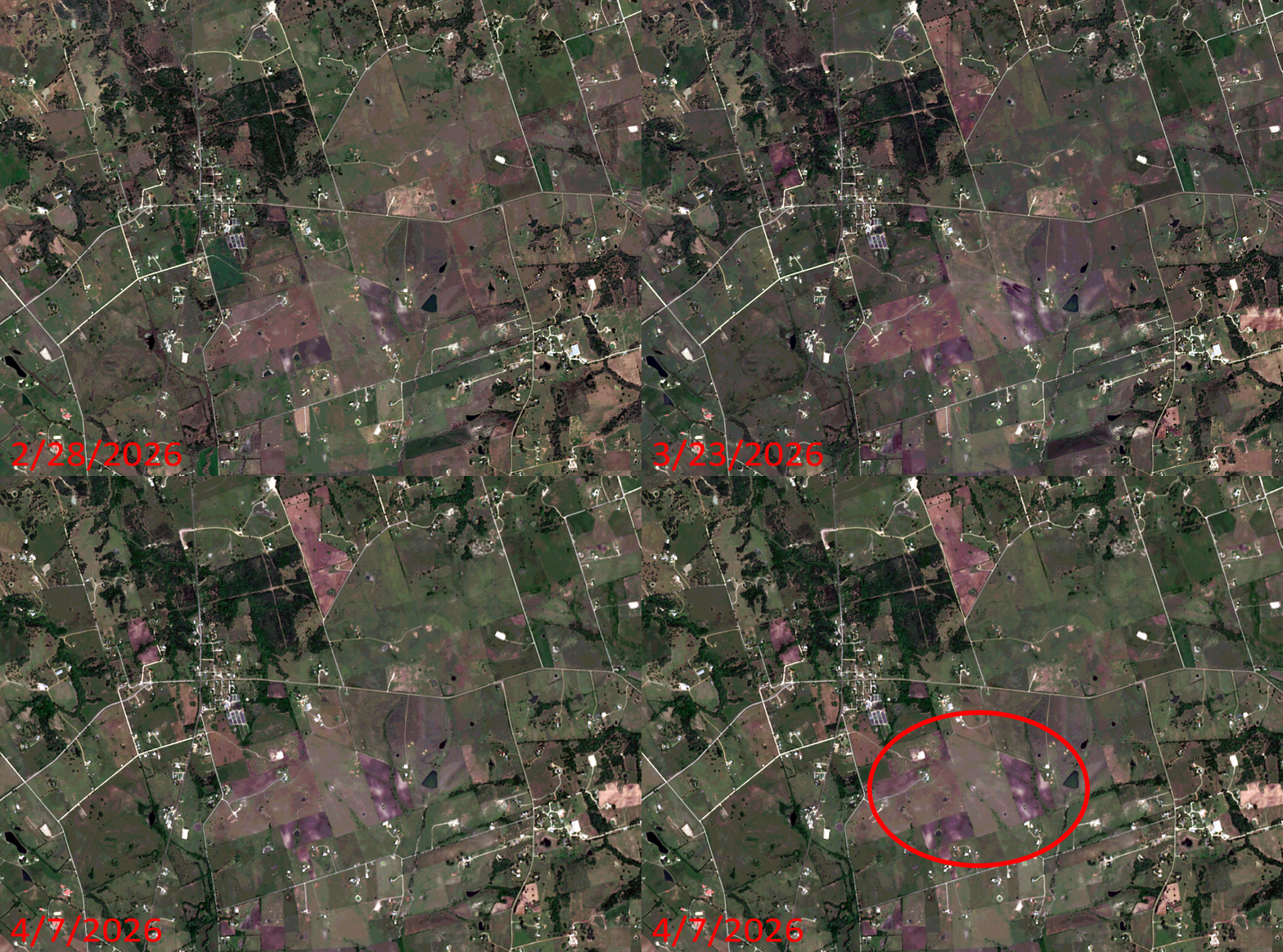 Click on the image above to see an animation of 3-meter natural color PlanetScope image collected over Brenham, Texas on February 28, March 23, and April 7, 2026. In this animation, you can see green return to this arid landscape in the March 23rd image and then by April 7th, the bluebonnets return, lending a purple hue to multiple fields in and around Brenham. In the final slide, we have circled a region to focus on where you can really see the bluebonnet fields coming alive with color. (Images Courtesy: © Planet 2026)
The PlanetScope Microsat Constellation
PlanetScope is a constellation of more than 240 microsats referred to individually as Doves. Each Dove is able to collect up to 20,000 square kilometers (sq km) per day of 3-meter (m) 4-band multispectral (i.e. blue, green, red and near-infrared [NIR]) imagery; and newly launched SuperDoves collect 8-band multispectral adding in valuable red-edge spectral data. Across the constellation, PlanetScope is archiving more than 200 million sq km of medium-resolution imagery a day, making it the go to source for daily imagery over most locations. This massive archive dates back to 2016, offering the most complete and continuous record of spatial data on the planet since the start of the constellation’s ongoing launch schedule. Collecting 3-meter multispectral imagery is the equivalent of ‘high-resolution’ multispectral data imaged by a 75-centimer (cm) satellite (as this satellite would feature 75-cm panchromatic and 3-m multispectral), making PlanetScope an extremely competitively priced option at just $2.25 per sq km. With well registered images and nearly daily collections of most locations, PlanetScope is the ideal imagery source for this current-events focused series, Our Changing Landscape.
Bluebonnet Blooms in Brenham, Washington County, Texas
As spring arrives in Texas, the state’s official flower begins to bloom. And like everything in Texas – even the bluebonnets are bigger than everywhere else. Known as the bluebonnet capital, Brenham, Texas, sits in the middle of bluebonnet country. During Spring, the town transforms into a sea of blue and becomes part of the popular Texas Bluebonnet Trail.
There’s wildflower etiquette guests are encouraged to follow when checking out the bluebonnets, as well as perfect places to picnic, so they can make it a full day. The interactive wildflower driving map changes every year, but helps guide locals and guests alike as they embark upon their bluebonnet adventure.
Bluebonnets are annual plants, completing their entire life cycle – from germination, to flowering, seeding, and finally dying – within a single season. While they are predominantly blue, though occasionally they bloom in shades of white, pink, and maroon due to genetic variations. There’s even a Facebook page dedicated to the various blooming stages of bluebonnets in Washington County to help floral enthusiasts know when to hit the trail and soak in their beauty.
If you would like to find out more about using 3-meter PlanetScope imagery for your academic studies, engineering projects or any landscape analysis, let us know at sales@apollomapping.com or (303) 993-3863.
If you are searching for medium and high-resolution satellite imagery, the search is over as Image Hunter is the solution you’ve been looking for! Featuring satellite and aerial imagery as well as digital elevation models (DEMs) from a constantly expanding list of 70+ constellations/datasets and 19 vendors, our database contains more than 500-million images/records meaning there is just no other website out there with this breadth of commercial data products. Our interface is slim-lined and modern, loading quickly on all platforms, browsers and operating systems. Further, our database is updated multiple times an hour with the most recent images collected by WorldView-3, Pléiades 1, PlanetScope, SuperView Neo and many more so you are sure to get the most current view of all the imagery and DEM databases we work with. Once you submit your request, an Apollo Mapping representative will be in touch within 4 Illinois business hours to get you the pricing information you need for your project.


So why wait? Give Image Hunter a try now to find the imagery and/or DEM data you need for your next mapping project!
Key Improvement(s) From The Past Month
The past month has seen us focusing on security, improved updates and general bug fixes. We do not have much to say as all of the fixes seemed important so let’s jump right into our list.
Here is a summary of the changes/improvements we made to Image Hunter during the past month:
- Some bots found a way around one of our security walls, so we beefed up security to block them moving forward!
- Airbus changed how Pléiades 1 and SPOT 6/7 stereo updates are communicated to us, so we updated the system to reflect this.
- Airbus also now gives us a combined stereo/tri-stereo footprint for their satellites and so you will see this footprint when you complete a stereo search. You can also clip to this footprint in our Clip Image To Polygon tool.
- We found a bug with persistent Image Hunter links and fixed it.
- Improved the update process so previews are rendered more reliably.
Our new Clip Polygon To Image tool is live! Give it a try to automatically calculate the coverage areas of a complex set of imagery from various data vendors and satellite constellations.
Data Alert – An Automated Daily Imagery Search
Have you checked out Data Alert which lets you define an area of interest anywhere around the globe, the resolution your project requires and the number of months we should keep the alert active? Once an alert is set up, we check for new data over your area of interest every single day, and send you an email when we find coverage that meets your specifications. We have a short YouTube video with directions to set up a Data Alert, check out the last video; and we have written directions for Data Alert here.
The Sensors Available in Image Hunter
As you might have seen in past articles, we now feature hourly updates (seriously!) of GeoEye-1, KOMPSAT 3/3A, Pléiades 1 and Neo, SPOT 6/7, SuperView-1/2/Neo, WorldView-1/2/3/Legion!
Image Hunter can be accessed 24 hours a day, 7 days a week and is a one-stop shop for every major source of medium and high-resolution satellite (and aerial!) imagery on the market today, including:
- WorldView Legion
- WorldView-4
- WorldView-3
- WorldView-2
- WorldView-1
- QuickBird
- GeoEye-1
- IKONOS
- EROS B
- KOMPSAT-3A
- KOMPSAT-3
- KOMPSAT-2
- Pléiades 1 constellation
- Pléiades Neo constellation
- TerraSAR-X (TerraSAR-X, TanDEM-X and PAZ)
- GEOSAT-1
- GEOSAT-2
- TripleSat
- BJ3A
- BJ3N
- SPOT 1 to 7 constellation
- RapidEye
- GaoFen-2
- GaoFen-1
- ZiYuan-3 01/02 (mono and stereo!)
- FORMOSAT-5
- FORMOSAT-2
- ALOS PRISM (stereo)
- AW3D Standard (DEM)
- SkySat constellation
- PlanetScope constellation (including 5-band SuperDove data)
- SuperView-1 constellation
- SuperView-2
- SuperView Neo-1 01/02/03/04
- SuperView Neo-3 01/02
- Landsat 1-8
- TeLEOS-1
- DS-EO
- Hexagon (HxGN Content Program aerial imagery) imagery + DEM
- WorldDEM
- WorldDEM Neo
- Vricon DEMs
- Orbita Hyperspectral Satellite (OHS)
- KazEOSat-1
- KazEOSat-2
- Jilin-1 Optical
- Jilin-1 Video (including nighttime imagery)
- Jilin-1 GF/DP
- Jillin-1 KF
- Orbita Video Satellites-1/2/3 (OVS-1/2/3)
- BlackSky Global series
Key Features of Image Hunter
If any of our readers have struggled with other geospatial search engines that are clunky, only query one data source and/or do not provide image previews, then Image Hunter is the solution to your woes as it features:
- Online browsing of satellite and aerial imagery from 19 data providers and 56 satellite and aerial imagery derived datasets.
- Near-instantaneous loading of low-resolution preview imagery with collection date, cloud cover and other key metadata.
- The ability to define your area of interest by address, coordinates, geometric shape or shapefile/KMZ.
- A responsive basemap with street names to provide spatial context when discovering data as well as crowd-sourced updates for the most accurate map possible.
- Exports of the area of interest you create as well as the scenes you select in shapefile or KMZ format.
- Support for all operating systems, and not just our friends with Windows machines!
Image Hunter can be accessed here all day and night, we are excited to find out what you think about our imagery search engine! So if you have any ideas and/or feedback to improve Image Hunter, please let us know at sales@apollomapping.com or (303) 993-3863.

 Click on the image above to see an animated views comparing 2.5-m and 5-m AW3D DEMs over Boston, Massachusetts and Washington, D.C. (C) NTT DATA, RESTEC, Included JAXA
In conjunction with our valued partner, NTT DATA, we are proud to offer 2.5-meter/5-meter (m) AW3D Standard DEM products from an archive covering more than 80% of the world. As an added bonus, you are able to search for AW3D Standard in Image Hunter, making this DEM fast to query, order and deliver.
Produced from an archive of more than 3 million ALOS stereo images, AW3D Standard can be delivered as either a digital surface model (DSM) or a digital terrain model (DTM) at 2.5-m and 5-m resolutions. With average delivery times of 3 weeks or less (even for a DSM), there is no high-resolution elevation model on the market we can get to you quicker.
Here is a summary of the current AW3D Standard specifications which will be updated in the coming months when more testing is completed on the new 2.5-m DEM offering:
Resolution: 2.5-m (also offered at 5-m for a reduced price)
Date of ALOS Images Used: 2006 to 2011
Horizontal and Vertical Accuracy: 5-m LC90 and LE90, or better
Product Levels: level 1 DSM (raw data); level 2 DSM (voids infilled); level 2 DSM (standard); level 3 DTM
Average Delivery Time: 2 to 4 weeks
If you have any pricing requests or additional questions about AW3D Standard DEMs, send us an email at sales@apollomapping.com.
In July, we looked at out the Schonbrunn Palace in Vienna, Austria. This month for the Pléiades 1 – Pléiades Neo Point of Interest, we check out Hallgrimskirkja in Reykjavik, Iceland.
Do you enjoy the high-resolution satellite imagery we post monthly in this article and elsewhere in The Geospatial Times? If so, head over to our Reddit subgroup, HighResSatelliteImage, where we will post some our favorite high-resolution satellite images on a weekly basis.
About the Point of Interest: A church and national sanctuary in Iceland called Hallgrímskirkja towers over Reykjavík. Its concrete facade pays homage to modernism and serves as a reminder of the stark Icelandic landscape. The church is named after the 17th Century clergyman Hallgrímur Pétursson, author of Hymns of the Passion. Hallgrímskirkja is an Evangelical-Lutheran church and is a part of the Evangelical-Lutheran Church of Iceland. The iconic structure happens to be one of the most visited places by tourists in Iceland. Every day, thousands of people visit the site, which is an active church still.

 These two satellite images prvide an aerial view of the Hallgrimskirkja in Reykjavik, Iceland. You can see the smooth, curved outline of the church in the 50-cm enhanced color Pléiades 1 image taken August 13, 2025. Hallgrimskirkja casts a huge shadow across the ground below, which is captured in the 30-cm Pléiades Neo 3 color image taken August 31, 2025. (Credit, PLEIADES © CNES 2026, Distribution Airbus DS.)
Fun Factoids: (1) The stained glass above the entrance to the church, and then the glass artwork in the doors into the nave, pulpit and baptismal font are the work of artist Leif Breiðfjörður. The decoration of the pulpit includes glass images of Hallgrímur Pétursson’s autograph of the Passion Psalms, as well as symbols of God the Father, Son and Holy Spirit. The back of the pulpit is a glass image showing the mark of Christ’s arrest, the Greek letters XP, and on both sides of it are the letters alpha and omega. (2) The church’s baptismal font from 2001 is made of Icelandic columnar rock and Czech lead crystal. The crystal is inscribed with scripture from Mark 16:16: “He who believes and is baptized will be saved.” (3) In the tower of Hallgrímskirkja, there are three large church bells and a carillon with 29 bells. The carillon is the first of its kind in Iceland. The church is one of three in the capital that beats time. The bells are rung to mark the general calendar, masses and other church ceremonies. (4) Hallgrímur Pétursson, Iceland’s most famous religious poet, was born in Gröf on Höfðastrond in 1614. When a group of Icelanders, who had been captured in Iceland and enslaved by pirates from Algeria, were bought free and stopped in Copenhagen on their way home, Hallgrímur was asked to review Christian teachings with the people after they had spent years among Muslims. Reverend Hallgrímur is best known for his Passion Psalms, fifty in number, which are a meditation on the martyrdom of Jesus Christ. (5) At 244 feet tall, Hallgrimskirkja is the largest church in Iceland and second tallest building in the country. (6) State Architect Guðjón Samúelsson‘s design of the church was commissioned in 1937. He is said to have designed it to resemble the trap rocks, mountains and glaciers of Iceland’s landscape, in particular its columnar basalt “organ pipe” formations (such as those at Svartifoss).
The 50-cm Pléiades 1 High-Resolution Satellite Constellation
The Pléiades 1 constellation (or at least part of it!) has been in orbit since December 2011 and if you have not had a chance to check out any sample imagery, take a few moments and have a look at the gallery on our website. If you work with high-resolution imagery, you should consider Pléiades 1 and Pléiades Neo for your next geospatial projects.
A variety of Pléiades 1 products are available from both a well-established archive and as a new collection, including 50-centimeter (cm) pansharpened imagery and 50-cm panchromatic – 2-meter (m) 4-band multispectral bundles. We are happy to discuss the technical specifications, pricing and tasking options available with both of these satellite constellations.
The 30-cm Pléiades Neo High-Resolution Satellite Constellation
Pléiades Neo is our newest high-resolution satellite constellation. The first Neo satellite went up in April 2021 and the second in August of the same year. This 30-centimeter resolution constellation will add two more satellites in the next few months and upgrade from daily to intraday revisits. Pléiades Neo has six multispectral bands with 1.2-meter resolution, including a deep blue and two infrared bands, along with a 30-centimeter resolution panchromatic band.
The archive is growing every day, and the satellites are available for new collections, making Pléiades Neo the perfect solution for site monitoring. Check out our beautiful sample images in the Pléiades Neo gallery.
More sample images and technical information about Pléiades 1 can be found on our website here; while the same can be found here for the Pléiades Neo constellation.
The Apollo Mapping sales team can answer any questions you might have about Pléiades 1 and/or Pléiades Neo. We can be reached at (303) 993-3863 or sales@apollomapping.com.
“If it hurts, you’ll always remember it.” – Adam from Girls
Part I:
Every once in a while, I’m forced to acknowledge that you never really know what someone else is thinking. Generally, I’m the type of person who oscillates somewhere between the impenetrable aloofness of a vagabond, the hair-trigger of a gunslinger, and the foolhardiness of a cynical optimist. I guess none of these are desirable categories to find oneself in, and that’s likely part of my problem: I’m either oblivious, fixed to kill, or engaged in well-meaning acts of self-deception. There’s no room for nuance, and even less attempt at developing simple awareness.
Fast-forward to my 30s and now 40s, and me trying to pursue relationships with women. Well, mostly I was just trying to get lucky. But occasionally, I’d find one that I really liked and try to make it work; they never did for long, and I bear the brunt of most of those flame-outs. It took me an awful long time to learn from my past mistakes, but I showed some signs of promise even if they remained stunted.
Fast-forward to last summer (2025), and I thought the stars had finally aligned. In a quick and unexpected event, a gal I’d known for six years strictly as a friend soon became a lot more than that, and while we weren’t “in love” or talking about the future, all signs pointed to those things being possible. Until one day I realized that I had no idea what she was thinking all along. How it felt apart, and so quickly, I still don’t have a full grasp on. But it’s been a year since it did, and it has long faded into the recesses of my mind. Thanks in part to the gal I found more recently.
And as much as I thought the Summer 2025 Chick could have long-term relationship potential, the one I linked up with around the holidays more recently screamed it (or so I came to think). This relationship moved fast. Communication was always strong. Excitement to see one another was always high. Squabbles and headbutting were largely avoided, and the few times where there was some tension, it was easily smoothed out. I felt overcome by this wave of feelings that washed over me, and thankfully, she had similar sensations. We were both hesitant to admit this at first, and hesitant to push the connection along too quickly, but it soon took on a life of its own. We talked of the future in a way I hadn’t done with a girl in quite some time, and we both believed in it. Everything outside of “us” became fuzzy to me, though I certainly don’t think I lost myself. If anything, I found a piece I’d been long missing. We were in a good place.
Then I looked up to see the train coming right at me.
 It can all be over in the blink of an eye. (Image retrieved from here and comes courtesy of Gustavo Fring.)
She’d been a little distant, or so it seemed, for a couple days, but nothing too weird; though, it did tingle my sixth sense. On a Friday she indicated that she was feeling a little “off kilter” and wanted to take the night to journal through her thoughts and feelings. We weren’t going to meet up until that Saturday anyway, so I didn’t make too much of it, especially since she assured me that whatever it was wasn’t about me. She said she was looking forward to seeing me the following day.
Often, I wake up to texts from her, especially when there hasn’t been much communication the day before. This was not the case. I went about my Saturday business, coming home around 11:30am and called her. No answer. I texted, “Is everything okay?” No answer. It wasn’t for another 90 minutes before I heard from her, but via email. We’ve communicated a lot by email, specifically when we have long things we want to think through to say to one another, but we hadn’t in a while – all of this was happening face-to-face these days.
It started out with trepidation, but the first line that really caught me off guard was this one: “To prepare you, this email is not intended to be a breakup email. But I guess it isn’t great, either.” I winced.
The very next line?
“Yesterday, an old flame contacted me for the first time in years. We had an intense history and were on and off for a while before I got married. We have been mostly no-contact for 10 years. Before yesterday, if someone had asked me what I would do in this situation, I would have thought that I would be mostly unbothered. But, to my surprise, I found myself wanting to reconnect with him. I was shocked with how hard it was for me to decide what I wanted to do.”
The train hit me head on.
It was right then that I was forced to acknowledge that I never really knew what she was thinking all along. I thought I did, but I was wrong. She seemed sincere, but I don’t know that I can believe that any longer – even if I still want to.
At this point, it’s all pretty raw. I’m very restless. I don’t want to talk about it to anyone but her, but she’s asked for at least another day. I don’t know if she’ll ask for more space tomorrow. I couldn’t resist the urge to write back to her; I felt that I was owed at least the right to respond in the moment, though I’d rather have done so to her face. I haven’t yet heard how my response was received…
The first time we hooked up, towards the end of the night I said to her, “Do you know how at the start of relationships there is always a lot of hope and possibility?” She smiled and nodded yes. I then said, “Let’s try to hold onto it for as long as we can.”
Now it seems that hope and possibility have slipped through my fingers. I probably couldn’t hold on much longer anyway; the train fucking ran me over.
Part II:
I went up to see her that Sunday, and I thought we’d worked things out, she was open about all of her concerns and the things she did and did not want in her life. She’s been married or with her husband for a decade, and before that, she’d had a series of short but intense relationships where she’s lived with her boyfriends. She didn’t want any of that anymore; it hadn’t worked for her. She assured me this had nothing to do with the guy from her past who contacted her out of the blue – it had more to do with what it jostled out of her in general. Besides, she said, she only knew herself in relationships. Who was she by herself? Things seems to have smoothed out after that conversation, despite her misgivings and unanswered questions, and we had a few good days over the next week or so, but she didn’t seem quite right.
Then the following week came and she was noticeably less communicative. I got that feeling that I knew something was off, but she wasn’t copping to it. A day shy of two weeks from receiving that email that upended what I thought I knew about her and us, she called me, teary-eyed, and said, “I can’t do this anymore.” I was in shock again.
It wasn’t a long conversation, and she apologized for not doing this in person. The next day we were to go to a wedding, my friends, and she said she’d still go. I asked her if we could talk before it, and she agreed. We had a nice, heartfelt conversation. I asked her if we could have as much fun at the wedding as we did on our first date, she said “yes” and we did. It may have been our best day spent together ever, and it came the day after the end of our relationship.
I only had about another week until an already-planned two-month trip out west, something that was going to be a challenge to the relationship in the absence of the new circumstances. She’d booked a flight to come visit, but that was off now. She agreed to spend one more day with me before I left – not the three we’d originally planned, but it was something. I made a very nice dinner, she stayed over, we had a great conversation, but it was left with the ball in her court – all the power in her hands. Not something I’m used to or comfortable with.
At the time of writing, it is exactly two weeks from when she broke up with me, but I still find myself holding onto the possibility we’ll get back together when I return. My rational brain knows it’s foolish, but my animal brain is trying to preserve this love and feeling for as long as it can. I told her I’d let her set the pace of communication while I’m gone; it’s the only option, really, if what she needs is time and space. It’s very hard for me. Especially because there is no guarantee on the other end of this.
I’m still holding onto Hope & Possibility, but I’m starting to think it’s all been a mirage. How can life change so quickly? I guess I should’ve been looking for the train. It never misses an opportunity to run me over.
Marco Esquandoles
Broken-Spirited and Brokenhearted
¡Bienvenidos a agosto! Nosotros en Apollo Mapping estamos gustosos de tenerlos otro mes aquí en los resúmenes españoles del mes de agosto.
Producto Destacado – BJ3N de Alta Resolución en 30 cm
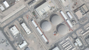 Una imagen a color nítida y detallada de una zona industrial en Doha, Qatar, captada por BJ3N en 30 cm el 1 de enero de 2023.
Si nunca ha visto una muestra de imágenes satelitales BJ3N con resolución de 30 cm, ¡ahora es el momento de hacerlo, ya que los datos son increíblemente nítidos y con colores vibrantes! De hecho, es una de las mejores imágenes satelitales de 30 cm que se encuentran actualmente en el mercado. Lanzado el 24 de agosto de 2022 desde Taiyuan, China, a bordo de un vehículo Long March CZ-2D, este satélite de alta resolución es una incorporación emocionante a nuestra creciente constelación de plataformas de imágenes de 30 cm.
Desarrollado por Twenty First Century Aerospace Technology, el satélite BJ3N cuenta con capacidades impresionantes que lo distinguen de sus predecesores. Su sensor pancromático captura imágenes con una resolución excepcional de 30 cm, ofreciendo vistas detalladas de la superficie de nuestro planeta. Su sensor multiespectral de 4 bandas recopila datos con resolución de 1.2 m que incluyen las bandas espectrales azul, verde, rojo e infrarrojo cercano (NIR). BJ3N es capaz de capturar imágenes de 500,000 kilómetros cuadrados por día, lo que le permite acumular grandes cantidades de datos sobre la superficie terrestre.
La expansión de nuestra oferta de imágenes satelitales de resolución de 30 cm brinda a investigadores, gerentes de proyectos y profesionales de SIG (GIS) información única sobre nuestro mundo cambiante. Ya sea que esté estudiando la mitigación de incendios, la planificación urbana y rural, o el monitoreo de la deforestación, BJ3N ofrece las imágenes detalladas de alta resolución que necesita para tomar decisiones informadas.
Profundice en estos datos de 30 cm con una muestra gratuita de imágenes BJ3N.
Y si desea una lista de precios actualizada que incluya imágenes satelitales BJ3N de 30 cm, o si tiene alguna pregunta sobre estos datos, ¡háganoslo saber por correo electrónico a sales@apollomapping.com ahora mismo!
Producto Destacado – DEM Estándar AW3D de 2.5 metros/5 metros
Haga clic en la imagen de arriba para ver vistas animadas que comparan los DEM AW3D de 2.5 m y 5 m sobre Boston, Massachusetts, y Washington, D.C. (C) NTT DATA, RESTEC, Incluye JAXAEn conjunto con nuestro estimado socio, NTT DATA, nos complace ofrecer productos DEM Estándar AW3D de 2.5 metros/5 metros (m) a partir de un archivo que cubre más del 80% del mundo. Como beneficio adicional, puede buscar AW3D Estándar en Cazador de Imágenes, lo que hace que este DEM sea rápido de consultar, ordenar y entregar.
Producido a partir de un archivo de más de 3 millones de imágenes estéreo de ALOS, AW3D Estándar puede entregarse como un modelo digital de superficie (DSM) o un modelo digital de terreno (DTM) en resoluciones de 2.5 m y 5 m. Con tiempos de entrega promedio de 3 semanas o menos (incluso para un DSM), no existe en el mercado otro modelo de elevación de alta resolución que podamos entregarle más rápido.
A continuación, un resumen de las especificaciones actuales de AW3D Estándar, las cuales se actualizarán en los próximos meses conforme se complete más pruebas sobre la nueva oferta de DEM de 2.5 m:
Resolución: 2.5 m (también disponible en 5 m a un precio reducido)
Fecha de las imágenes ALOS utilizadas: 2006 a 2011
Precisión horizontal y vertical: 5 m LC90 y LE90, o mejor
Niveles de producto: Nivel 1 DSM (datos sin procesar); Nivel 2 DSM (vacíos rellenados); Nivel 2 DSM (estándar); Nivel 3 DTM
Tiempo de entrega promedio: 2 a 4 semanas
Si tiene alguna solicitud de precios o preguntas adicionales sobre los DEM Estándar AW3D, envíenos un correo electrónico a sales@apollomapping.com.
Vista de Pájaro – Santiago, Chile

 Para julio, presentamos dos imágenes en vista de pájaro de la ciudad más grande y capital de Chile, Santiago. Estas dos imágenes fueron captadas sobre el centro de Santiago, y una de ellas muestra el Parque Metropolitano de Santiago a la distancia. Estas imágenes en vista de pájaro fueron captadas por WorldView-3 el 1 de marzo de 2019 con una resolución de 86 centímetros. (Imágenes Satelitales © 2026 Vantor)
Cada mes, presentamos una nueva imagen satelital en vista de pájaro de un lugar seleccionado alrededor del mundo; y para este mes, nos dirigimos al hemisferio sur con una vista oblicua de Santiago, Chile.
¿Qué es la imagen satelital en vista de pájaro?
Bueno, esa es una buena pregunta que nos complace responder. Cuando un satélite capta imágenes del suelo debajo de él, siempre existe cierta inclinación en la cámara mientras observa hacia abajo. Esta inclinación se llama fuera de nadir (off-nadir) y se mide en grados a partir de 0°; por lo tanto, 0° fuera de nadir significa que el satélite apunta directamente hacia el suelo al captar la imagen, mientras que 90° fuera de nadir significaría que el satélite apunta hacia un lado y ni siquiera está enfocando el suelo debajo de él al momento de la captura. La gran mayoría de las imágenes satelitales se recopilan con un ángulo fuera de nadir inferior a 30°. Sin embargo, en raras ocasiones, ya sea por solicitud de un cliente o para capturar un desastre natural u otro evento importante, un satélite puede inclinarse y captar imágenes en un rango de 35° a 50°, lo cual consideramos ideal para imágenes de alto ángulo fuera de nadir, también llamadas imágenes en vista de pájaro o imágenes oblicuas. Estas imágenes en vista de pájaro ofrecen una perspectiva única a las imágenes satelitales, brindando una vista amplia del paisaje desde un costado. Esperamos que disfrute de las imágenes satelitales en vista de pájaro que compartimos en este artículo. Y si tiene alguna pregunta sobre este tipo de datos o sobre cualquiera de los productos de imágenes con los que podamos ayudarle, ¡envíenos un correo electrónico en cualquier momento a sales@apollomapping.com!
Si está interesado en más imágenes satelitales en vista de pájaro de esta ubicación, visite nuestro subgrupo de Reddit, BirdsEyeViewImagery, y hágase miembro. Publicamos imágenes satelitales de alto ángulo fuera de nadir todos los viernes en el subgrupo BirdsEyeViewImagery, la mayoría de las cuales no se publican aquí.
Fernando Gutierrez
Topographic Translator
If you have never seen a sample of 30-cm resolution BJ3N satellite imagery now is the time to do so as the data is just incredibly crisp with vibrant colors! In fact, it is some of the best 30-cm satellite imagery we see on the market currently. Launched on August 24, 2022 from Taiyuan, China, aboard a Long March CZ-2D vehicle, this high-resolution satellite is an exciting addition to our growing constellation of high-resolution 30-cm imaging platforms.
A crisp and detailed color image of an industrial area in Doha, Qatar collected by 30-cm BJ3N on January 1, 2023.Developed by Twenty First Century Aerospace Technology, the BJ3N satellite boasts impressive capabilities that set it apart from its predecessors. Its panchromatic sensor captures imagery at an exceptional 30-cm resolution, providing detailed views of our planet’s surface. Its 4-band multispectral sensor collects 1.2-m resolution data that includes blue, green, red, and near-infrared (NIR) spectral bands. BJ3N is capable of imaging 500,000 square kilometers per day, allowing it to accumulate vast amounts of data about the Earth’s surface.
Expanding our 30-cm resolution satellite imagery offering provides researchers, project managers, and GIS professionals unique insights into our changing world. Whether you’re studying fire mitigation, urban and rural planning, or monitoring deforestation, BJ3N offers the detailed high-resolution imagery you need to make informed decisions.
Delve deeper into this 30-cm data with a free sample of BJ3N imagery.
And if you would like an updated price list that includes 30-cm BJ3N satellite imagery or you have any questions about this data, let us know by email at sales@apollomapping.com now!
For July, we feature two bird’s eye view images from the largest city and capital of Chile, Santiago. These two images were collected over downtown Santiago and one of them captures Santiago Metropolitan Park in the distance. These bird’s eye view images were collected by WorldView-3 on March 1, 2019 with 86-centimeter resolution. (Satellite Imagery © 2026 Vantor)Each month, we feature a new bird’s eye view satellite image from a select location around the globe; and for this month, we head to the southern hemisphere with an oblique view of Santiago, Chile.
What Is Bird’s Eye View Satellite Imagery?
Well, that’s a good question we are happy to answer! When a satellite images the ground below it, there’s always some tilt to the camera as it looks down. This tilt is called off-nadir and is measured in degrees from 0; and so, it follows that 0° off-nadir means that the satellite is pointing directly down at the ground when it images, while a 90° off-nadir would mean that the satellite is pointing to the side and not even at the ground below it when it images. The vast majority of satellite imagery is collected with an off-nadir below 30°. However, in rare occasions, be it by a customer request, or to capture a natural disaster or other important event, a satellite can tilt and image in the range of 35° to 50° which we consider ideal for a high off-nadir imagery, also called bird’s eye view imagery and oblique imagery. These bird’s eye view images lend a unique perspective to satellite imagery that is an expansive view of the landscape from the side. We hope you enjoy the bird’s eye view satellite imagery that we share in this article. And if you have any questions about this type of data or any of the imagery products we can help you with, send us an email at any time to sales@apollomapping.com!
If you are interested in additional bird’s eye view satellite images from this location, head over to our Reddit subgroup, BirdsEyeViewImagery, and become a member. We post high off-nadir satellite imagery every Friday in the BirdsEyeViewImagery subgroup – most of which is not posted here.