

If you have never seen a sample of 30-cm resolution BJ3N satellite imagery now is the time to do so as the data is just incredibly crisp with vibrant colors! In fact, it is some of the best 30-cm satellite imagery we see on the market currently. Launched on August 24, 2022 from Taiyuan, China, aboard a Long March CZ-2D vehicle, this high-resolution satellite is an exciting addition to our growing constellation of high-resolution 30-cm imaging platforms.
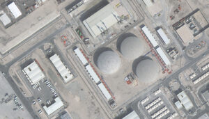 A crisp and detailed color image of an industrial area in Doha, Qatar collected by 30-cm BJ3N on January 1, 2023.
Developed by Twenty First Century Aerospace Technology, the BJ3N satellite boasts impressive capabilities that set it apart from its predecessors. Its panchromatic sensor captures imagery at an exceptional 30-cm resolution, providing detailed views of our planet’s surface. Its 4-band multispectral sensor collects 1.2-m resolution data that includes blue, green, red, and near-infrared (NIR) spectral bands. BJ3N is capable of imaging 500,000 square kilometers per day, allowing it to accumulate vast amounts of data about the Earth’s surface.
Expanding our 30-cm resolution satellite imagery offering provides researchers, project managers, and GIS professionals unique insights into our changing world. Whether you’re studying fire mitigation, urban and rural planning, or monitoring deforestation, BJ3N offers the detailed high-resolution imagery you need to make informed decisions.
Delve deeper into this 30-cm data with a free sample of BJ3N imagery.
And if you would like an updated price list that includes 30-cm BJ3N satellite imagery or you have any questions about this data, let us know by email at sales@apollomapping.com now!


 Copyright © 2025 All Rights Reserved -
Leave a Reply