
 This map shows the areas imaged by the WorldView-2/3 constellation from January 1 to March 31, 2019 over Australia and its islands. Please note that in many instances, multiple images were collected over the same area which is difficult to portray on this static map.
In this monthly piece, we give our readers a sense of the high-resolution imagery coverage collected over a geography during a specified window. To do this, we pick a high-resolution satellite constellation, a defined time period and area of interest, then report key statistics on the total amount of imagery collected in square kilometers (sq km). Without further delay, let’s jump into our analysis.
Graphic Region of Interest: Australia plus islands
Land Mass Covered: 7,683,406.3 sq km
Time Period: January 1 to March 31, 2019
High-Resolution Satellite Constellation: WorldView-2/3
WorldView-2/3 Constellation Imaging Statistics–Australia
Total Area Collected: 3,546,918.3 sq km; 19,705.1 sq km per satellite/per day
Area Collected @ 20% or Less Clouds & 30 Degrees or Less Off-Nadir: 2,330,309.7 sq km; 12,946.2 sq km per satellite/per day; 65.7% of total

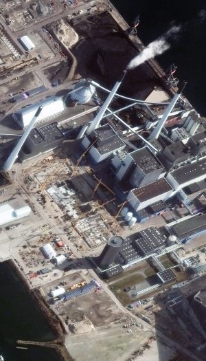
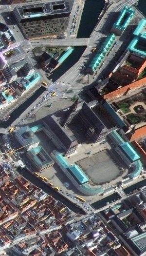


If you have never seen high off-nadir imagery before you are in for a treat this month! High off-nadir imagery means that the satellite’s camera was titled at a high angle (nearly 45 degrees) with respect to the ground when the data was captured, resulting in a side view of the landscape as opposed to top-down. And wow, these images are just fun! These five colorful views of Copenhagen, Denmark were collected on March 25, 2017 by WorldView-4 at an average resolution of 52-centimeters. Admittedly spring is not the best time to image this far north given how low the Sun is in the sky, but as Copenhagen is cloudy, we were happy to find this cloud-free, high off-nadir view. These WorldView-4 images have been resampled and enhanced by Apollo Mapping for improved colors, clarity and perspective. (Images Courtesy: Maxar)
Every time we look at WorldView-3 and WorldView-4 (WV3/4) imagery, we are blown away. And we hope you are equally impressed with the data! For the August 30-cm Color WorldView-3/4 Image of the Month we checked out the ‘view’ from the fourth tallest tower in the world, and for this month we travel to Europe with a look at high off-nadir imagery–or a high tilt angle of the camera in relation to the ground below–which lends a unique view of Copenhagen, Denmark. Oh and since these are big images at a different angle, we feature thumbnails only to the right but when you click on the images, you will see them in full resolution!
PLEASE NOTE: Effective May 2016, WorldView-3/4 prices dropped again! Are you interested in finding out more about these price drops? If so, send us an email at sales@apollomapping.com.
WorldView-3 launched in late 2014 and WorldView-4 launched in late 2016; taken together they are the most advanced satellite constellation the commercial marketplace has ever had access to. Here are a few of the features that really set these satellites apart from the competition:
- Improved Resolution
- Higher resolution means you can see more detail in WV3/4 imagery.
- Data collected at nadir will have 31-centimeter (cm) panchromatic, 1.24-meter (m) visible and near infrared, 3.7-m SWIR (WV3 only) and 30-m CAVIS (WV3 only) bands.
- At 20 degrees off-nadir, the resolution is 34-cm panchromatic, 1.38-m visible and near infrared and 4.1-m shortwave infrared.
- Additional Spectral Bands
- If spectral analysis is part of your project, then no other satellite can match WV3 with its: 8 bands of visible and near-infrared data; and 8 shortwave infrared bands which are crucial for geological studies.
- Better Positional Accuracy
- With accuracies of 3.5-m CE90% or better (without ground control even!), WV3/4 has no rivals for its enhanced positional accuracy.
- Daily Revisits
- At 40 degrees latitude, WV3 is able to image every location daily with 1-meter or better resolution and then every 4.5 days at 34-cm resolution or better.
- WV4 is no longer collecting new imagery.
- Increased Collection Capacity
- WV3/4 feature 13.1-km swath widths (at nadir) with the ability to collect up to 680,000 square kilometer (sq km) of high-resolution data per day per satellite (though WV4 is dead now).
- Improved control movement gyros translate into larger maximum contiguous collection areas per pass, with up to ~7,500 sq km of mono imagery and ~3,000 sq km of stereo possible.
If you are interested in WorldView-3 and/or WorldView-4 imagery for your next project, please let us know by phone, 303-993-3863, or by email, sales@apollomapping.com.
You can also find more WV3 samples and technical information on our website here and then WV4 samples and information can be found here.
NASA, along with the rest of the world, has its sights set on the Moon. Our closest neighbor and a proving ground for deep space technology, the Moon offers all the challenges of survival at a more manageable distance than Mars. As part of the Artemis program, plans are in the works for the Lunar Gateway. It sound like an impressive structure, but it’s actually a small spaceship that will obit the Moon.
The Lunar Gateway will pale in comparison to the International Space Station in terms of its size, but serve a similar purpose. Astronauts will visit the station once a year and can stay for up to three months to conduct experiments in onboard labs. It serves as a stop off point for missions to the Moon or deep space excursions. The gravity on the Moon and Mars makes travel from space to the surface more expensive and logistically difficult. Transferring supplies to an orbiting spacecraft uses less fuel. From there, materials and astronauts can make the trip to the lunar surface using specialty spacecraft designed just for that purpose.
With this in mind, NASA is looking for proposals from American companies to provide supplies to the Lunar Gateway. While NASA takes care of the crew, commercial companies will vie for the opportunity to send supplies and experiments to the Lunar Gateway, just like the International Space Station. The contract is for 15 years with a maximum award of $7 billion.
It’s all part of a larger program called Artemis. Its mission is to land the first woman and the next man on the Moon by 2024. The Space Launch System (SLS), a powerful rocket that has been in production for years, along with the Orion spacecraft are included in this mission as well. The SLS and Orion will send astronauts into space and to the Lunar Gateway.
The Artemis 1 mission, slated for 2020 will be the first uncrewed test flight of the SLS and Orion spacecraft. This will be followed by Artemis 2 in 2022 with the first crewed mission. Artemis 3 in 2024 aspires to put boots back on the Moon. Maxar Technologies is working on a power and propulsion element as a mobile command and service module. NASA is negotiating with companies for a habitation module for the Lunar Gateway.
The race is on—again—to make it to the Moon.
Where humans lead, trash follows. Space is no exception. Orbiting our planet is an unknown amount of space junk. There is a very real risk of this junk colliding and creating small pieces of debris that go on to damage other satellites. This damage turns into more small debris, setting off a chain reaction of destruction. Low earth orbit would be inundated with these small particles that shred larger satellites. It would be nearly impossible to launch a satellite into orbit without the junk destroying them. This is known as the Kessler Effect. The movie Gravity was a dramatization of this phenomenon.
Once again, our lack of forethought and inability to deal with a known issue until we absolutely have to, has left us vulnerable to a catastrophic future. Dealing with the issue afterward is short sighted and at that point it may be too late.
Currently, most satellites degrade in orbit until they burn up in the atmosphere, this can take years and it can still be dangerous to surrounding satellites.
The European RemoveDebris mission came up with a few options to reduce the junk in space and recently tested it out. On September 16, the RemoveDebris spacecraft released a small cubesat that inflated a 3-foot-wide object to mimic the size of actual space debris. Once it was about 19 feet away, the main spacecraft ejected a net to capture the cubesat. The video they took is super cool.
Once captured, the plan is to attach a sail to the junk, increasing its drag and quickening its descent into Earth’s orbit. They are also testing a harpoon system with the same sail. Interestingly, they couldn’t test it on real junk since each piece of trash still belongs to the original owner.
In other space news, brought to you by the United States, who is excited to see Redbull on the side of the next rocket headed for space? Or maybe watch an astronaut, usually a trained scientist, not a NASCAR driver, extol the virtues of Prada perfume? Oh boy, you know I am! Because why explore space for science when you can do it for profit?
There are people in this world who see a blank canvass and imagine filling it with advertising. I’d rather someone come along and tag it than see an advertisement for Ford.
I imagine an astronaut dressed as Billy Dee Williams with a can of Colt 45, saying, “It works every time,” while floating in microgravity. Maybe that’s exactly how NASA Administrator Jim Birdenstine imagines the future of NASA. Another commercialized industry, driven by profit instead of exploration. Maybe when they send up the next LandSat satellite it will be endorsed by Exxon. So instead of looking for life or delving into the mysteries of our own existence, we’ll focus on mining asteroids and terraforming a planet inundated with radiation, instead of realizing we are standing on the only planet that can harbor life in our solar system.
It’s adorable he thinks that the hour long talk is going to be viewed by the public at-large. His talk continues the us versus them rhetoric around mining rare earth metals while at the same time celebrating the partnership within the International Space Station. He can’t seem to decide whether he should be collaborative or elitist. The shift is toward making money at every turn, or any turn at this point, from company names on rockets to astronauts acting like Olympic athletes on cereal boxes.
He even brought up creating human organs in space in relation to commercial profits… human organs, for commercial profit. Not to save lives, but for profit. So save your pennies for that heart transplant because this country couldn’t care less about your life, only your money.
It’s not a future I’m looking forward to, where the end goal is profit over science and exploration.
If you are searching for medium and high-resolution satellite imagery, the search is over as Image Hunter is the solution you’ve been looking for! Featuring satellite and aerial imagery as well as digital elevation models (DEMs) from a constantly expanding list of 40+ sensors/datasets and 15 vendors, our database contains more than 64-million images/records meaning there is just no other website out there with this breadth of commercial data products. Our interface is slim-lined and modern, loading quickly on all platforms, browsers and operating systems. Further, our database is updated multiple times an hour with the most recent images collected by Maxar-DigitalGlobe, Airbus, Planet and more so you are sure to get the most current view of all the imagery and DEM databases we work with. Once you submit your request, an Apollo Mapping representative will be in touch within 4 Colorado business hours to get you the pricing information you need for your project.
So why wait? Give Image Hunter a try now to find the imagery and/or DEM data you need for your next mapping project!
Key September 2019 Improvement(s)
The past month has seen significant improvements to our preview update process as well as database security. We also added in some new collection times and enhanced PlanetScope imagery as well as a button to fix up broken or missing previews!
Here is a list of the major changes we made to Image Hunter in the past month:
- PlanetScope imagery searches now include data from Doves with the enhanced PS2.SD optical filter.
- Added a Refresh Preview button to the Info modal to fix up missing or bad previews.
- Introduced UTC collection times for Pleiades 1 and SPOT imagery–they are filling in slowly but should be done in the next few weeks.
- Fixed an error where logged in users could not submit a mixed DEM and imagery order, thanks Igor for finding that!
- Implemented rate limits to block automated scraping of our image preview database which can slow down the service for our valued users–take that hackers!
- Sped up the order submission process by reducing the number of elements passed to email.

Data Alert–An Automated Daily Imagery Search
Have you checked out Data Alert which lets you define an area of interest anywhere around the globe, the resolution your project requires and the number of months we should keep the alert active? Once an alert is set up, we check for new data over your area of interest every single day, and send you an email when we find coverage that meets your specifications. We have a short YouTube video with directions to set up a Data Alert, check out the last video; and we have written directions for Data Alert here.
The Sensors Available in Image Hunter
As you might have seen in past articles, we now feature hourly updates (seriously!) of GaoFen 1/2, GeoEye-1, KOMPSAT 2/3/3A, Pléiades 1, SPOT 6/7, SuperView-1, TripleSAT, WorldView-1/2/3/4 and ZiYuan-3!
Image Hunter can be accessed 24 hours a day, 7 days a week and is a one-stop shop for every major source of medium and high-resolution satellite (and aerial!) imagery on the market today, including:
- Worldview-4
- WorldView-3
- WorldView-2
- WorldView-1
- QuickBird
- GeoEye-1
- IKONOS
- EROS B
- KOMPSAT-3A
- KOMPSAT-3
- KOMPSAT-2
- Pléiades 1 constellation
- Deimos-1
- Deimos-2
- TripleSat
- SPOT 1 to 7 constellation
- RapidEye
- GaoFen-2
- GaoFen-1
- ZiYuan-3 01/02 (mono and stereo!)
- Formosat-2
- ALOS PRISM (stereo)
- AW3D Standard (DEM)
- SkySat constellation
- PlanetScope constellation
- SuperView-1 constellation
- Landsat 1-8
- TeLEOS-1
- Hexagon (HxGN Content Program aerial imagery)
- WorldDEM
- Vricon DEMs
Key Features of Image Hunter
If any of our readers have struggled with other geospatial search engines that are clunky, only query one data source and/or do not provide image previews, then Image Hunter is the solution to your woes as it features:
- Online browsing of satellite and aerial imagery from 15 data providers and 44 satellite and aerial imagery derived datasets.
- Near-instantaneous loading of low-resolution preview imagery with collection date, cloud cover and other key metadata.
- The ability to define your area of interest by address, coordinates, geometric shape or shapefile/KMZ.
- A responsive basemap with street names to provide spatial context when discovering data as well as crowd-sourced updates for the most accurate map possible.
- Exports of the area of interest you create as well as the scenes you select in shapefile or KMZ format.
- Support for all operating systems, and not just our friends with Windows machines!
Image Hunter can be accessed here all day and night, we are excited to find out what you think about our imagery search engine! So if you have any ideas and/or feedback to improve Image Hunter, please let us know at sales@apollomapping.com or (303) 993-3863.
Do you have the need for regularly updated images of locations around the world?
Perhaps you need imagery to integrate with an OEM solution you are developing?
Or maybe your organization uses large amounts of high-resolution imagery each year, and you are seeking a low-cost option for this data?
If you answered yes to any or all of these questions, then the solution you are looking for is DigitalGlobe’s EarthWatch (formerly called Global Basemap or GBM).
With EarthWatch, you have access to millions of square kilometers of streamed imagery with low cloud-cover and off-nadir angles. This data is accessible in web-mapping services and in an online viewer. Perhaps the most important feature of EarthWatch are the regular streaming updates you can receive as out-dated imagery is often of little or no use to our valued clients.
And if the EarthWatch streaming database lacks the coverage you need, Premium users are now able to download any image from the entire DigitalGlobe archive in a wide variety of formats!
September 2019 Product Update
 The available DigitalGlobe EarthWatch imagery over South America by location and with the most recent coverage date indicated with varying colors. In the vast majority of locations, there are multiple imagery dates available.
During August we checked out the EarthWatch coverage in the product’s flagship regions of the USA and Canada, and for this first unofficial month of fall we pivot to our southern neighbors with a look at the EarthWatch coverage over South America. And okay South America is a cloudy place so you cannot expect the best coverage over the Amazon, but along the coasts and mountains you will see tons of recent coverage. Here are more of the EarthWatch coverage statistics:
- South America EarthWatch Coverage By Year
- Less than 1 year (yr) old–11,249,312 sq km, 63.53% coverage of South America
- 1 to 2 yr old–12,252,471 sq km, 69.19% coverage
- 2 to 3 yr old–13,876,814 sq km, 78.37% coverage
- 3 to 4 yr old–11,553,863 sq km, 65.25% coverage
- 4 yr old and greater–16,538,447 sq km, 93.40% coverage
- Total coverage–65,470,907 sq km
- Total (approximate) area considered–17,707,537 sq km
EarthWatch Product Specifications
- Accessible Geographic Regions: global (unless geo-fencing specifically requested by client)
- Maximum Imagery Resolution: 50-centimeters through WMS and WCS; 30-cm for other delivery mechanisms
- Data Sources: primary = WorldView-2/3/4 and GeoEye-1; secondary = QuickBird, IKONOS, WorldView-1 and aerial
- Imagery Holdback Period For Updates: 90 day holdback for EarthWatch Standard; 2 day holdback for EarthWartch Premium; updates are to limited portions of the database, not the entire database
- Data Accuracy: at least 8.5-meter CE90%
- Database Access: OGC streaming services (i.e. WMS, WMST, WCS and WFS), Google Earth streaming services (i.e. EarthService), ArcGIS plugin (i.e. ImageConnect), offline database/downloads and online portal
- Annual Downloads & Streaming Limits: Standard = 4 gigabytes (GB) and up, annual license for downloads; Premium = 2 GB and up, perpetual license for downloads
- Maximum Concurrent Users: unlimited!
- Data Layers: Standard = standard image strips, +Vivid country-wide mosaics, and OSM and Google Maps vectors; Premium = standard, +Daily and First Look image strips, +Metro, +Vivid and Landsat mosaics, and OSM and Google Maps vectors
- Pricing Model: Standard and Premium tiered annual pricing models with increasing download and streaming limits
EarthWatch Direct Archive Download Specifications
Premium EarthWatch users are able to download high-resolution satellite imagery from the entire DigitalGlobe archive in a variety of formats. Here are some details on this exciting offering:
- Available Data Sources: entire commercial archives of GeoEye-1, IKONOS, QuickBird and WorldView-1/2/3/4 (SWIR included too!)
- Annual Downloads Limits: 2 GB and up; metering combined with streaming usage
- Product License: internal use and perpetual
- Product Resolution: maximum resolution for each satellite
- Product Formats: all standard types are offered including, orthoready, stereo, basic, 4-band bundle, 8-band bundle, ACOMP on, etc.
For more information on the pricing and coverage available in DigitalGlobe’s EarthWatch, you can reach our sales team anytime at sales@apollomapping.com or during typical American business hours at (303) 993-3863.
In August we checked out a very historic cricket ground located on the other side of the ‘pond’ from us, and for this September Pléiades 1–SPOT 6/7 Stadium of the Month we stay close to home for the site of an NCAA college football rematch between former Big 12 foes, Folsom Field in Boulder, Colorado, USA.

 A 50-cm color image of Folsom Field in Boulder, Colorado, USA collected on April 23, 2019 by Pléiades 1A; and then a 1.5-m SPOT 7 image of the same college stadium collected on June 28, 2019. These images have custom processing and color balancing applied by Apollo Mapping. PLEIADES © CNES 2019, Distribution Airbus DS. SPOT © Airbus DS 2019.
About the Venue: Located within less than one mile from our corporate headquarters in Boulder, Colorado, Folsom Field sits atop the hill that is University of Colorado’s campus with a prominent position overlooking the Boulder Creek below and the Front Range and Flatirons to the west. If you have never been to an event/game/wedding/etc. at Folsom Field we suggest you make the voyage to Boulder, Colorado, it’s truly an amazing town. Okay sorry for digressing, back to the history of Folsom Field which seems to have literally been planned and built in a single year according to this document. Originally opened in 1924 as Colorado Stadium with seats for 26,000 fans, it was renamed Folsom Field in 1944 when the beloved Coach Frederick Folsom passed away. Having lived in Boulder for nearly 20 years, we have seen the stadium grow with the town, with the last renovation complete in 2016 where the ‘bowl’ was closed on the north side. The current seating capacity of Folsom Field is 53,750–if you would like a more detailed history of the venue, here is a nice read.
Fun Factoids: (1) In 2018, former Big 12 foes, the University of Colorado Buffaloes and the University of Nebraska Cornhuskers, revived their annual series with the Buffs defeating the Cornhuskers on the road. This year’s edition will be held at Folsom Field on Saturday September 7th–will the Buffs sweep the series? We hope so J (2) While Folsom Field hosted multiple music events in the 1970s, including several by the Grateful Dead, for 15 years the stadium was quiet other than the annual football season. All that changed in 2016 when Dead and Co returned to Folsom Field and they have been here each year since! The past two years have seen two-night tour-closing sets that lit up the Flatirons with the sounds of the Dead once more. (3) Folsom Field is the fifth highest stadium in college football at 5,360 feet (1634 meters).
The Pléiades 1 High-Resolution Satellite Constellation
The Pléiades 1 constellation (or at least part of it!) has been in orbit since December 2011 and if you have not had a chance to check out any sample imagery, take a few moments and have a look at the gallery on our website. If you work with high-resolution imagery, you should consider Pléiades 1 for your next geospatial project.
A variety of Pléiades 1 products are available from both a growing archive and as a new collection, including 50-centimeter (cm) pansharpened imagery and 50-cm panchromatic–2-meter (m) 4-band multispectral bundles. We are happy to discuss the technical specifications, pricing and tasking options available with this satellite constellation.
The SPOT Medium-Resolution Satellite Constellation
The SPOT medium-resolution constellation consist of seven satellites launched from 1986 to 2014 with the most recent additions, SPOT 6 and SPOT 7, launching in 2012 and 2014 respectively. SPOT 6 and SPOT 7 are twin satellites offering 1.5-m panchromatic and 6-m 4-band multispectral data with a massive footprint at 60-kilometers (km) wide. For projects requiring recent archive coverage or rapid new collections of medium-resolution data, SPOT 6/7 should be one of your top imagery sources!
More sample images and technical information about Pléiades 1A and 1B can be found on our website here; while the same can be found here for the SPOT constellation and specifically about SPOT 6/7.
The Apollo Mapping sales team can answer any questions you might have about Pléiades 1 and/or any of the SPOT satellites. We can be reached at (303) 993-3863 or sales@apollomapping.com.
¡Bienvenidos a la quinta edición de Los Resúmenes Españoles!
 (Imagen cortesía de: DigitalGlobe. Procesado por Apollo Mapping para mejorar la precisión y claridad del color).
Your Imagery Work Break–2018 Burning Man
Encantamos mapas.
Encantamos imágenes.
Encantamos los descansos de trabajo.
Esperamos que te gusten también.
Estos días de verano están limitados, entonces, ¡toma la oportunidad para un descanso ahora! Antes de que te vayas, toma un minuto para revisar esta imagen del festival Burning Man, capturado en el 29 de agosto de 2018, por el satélite WorldView-2. Burning Man es un festival de música y artes que forma su propia ciudad, llamada Black Rock City, en Nevada, Estados Unidos, cada año para una semana de locura. Lo hemos cubierto en el pasado (ambos en 2017 y 2016), y esperamos que esta imagen traiga algunos flashbacks divertidos para quienes asistieron.
¡Que tengas un buen día de trabajo!
Si nunca has visto imágenes que son muy fuera-de-NADIR (que te dan una vista lateral), este mes tienes buena suerte. Estas cinco vistas vistosas de Copenhague, Dinamarca, fueron recolectados en el 25 de marzo, 2017, por WorldView-4 a una resolución promedio de 52-cm. (Imágenes cortesía de: Maxar)
30-cm Color WorldView-3/4 Image of the Month–Copenhagen, Denmark
Siempre cuando miramos imágenes de WorldView-3 y WorldView-4, estamos tan impresionados. Para agosto, revisamos la ‘vista’ del cuarto más alto edificio en el mundo, y este mes viajamos a Europa para ver algunas imágenes que son fuera-de-NADIR (alto ángulo entre la cámara y el suelo). Debido al alto ángulo, podemos ver una vista única de Copenhague, Dinamarca.
Aquí son algunas características que establece la constelación de WorldView3/4 aparte de otras:
- Resolución Mejorado
- Alta resolución significa más detalles.
- Los datos recopilados en el NADIR tendrán bandas pancromáticas de 31-cm, 1.24-m visibles e infrarrojo cercano, SWIR de 3.7-m (solo WV3) y bandas CAVIS de 30-m (solo WV3).
- Bandas Espectrales Adicionales
- Si análisis espectral es parte de su proyecto, nada puede igualar WV3 con sus 8 bandas visibles e infrarrojo cercano, y 8 bandas SWIR que son cruciales para los estudios geológicos.
Si tiene interés en imágenes de WorldView-3/WorldView-4 para su próximo proyecto, por favor contáctenos por teléfono a +1 (303) 993-3863, o por correo electrónico a sales@apollomapping.com.
Our Changing Landscape–Volcano Sabancaya, Peru

Haga clic en la imagen de arriba para ver una animación de imágenes de 5-metros color natural RapidEye recolectados sobre Sabancaya, Peru, en el 23 de noviembre, 2010, el 5 de agosto, 2017, y el 11 de mayo, 2018. Puede ver dos cambios significantes: primero, tanto en las imágenes de 2017 como de 2018, hay un penacho activo arriba de Sabancaya. Segundo es la diferencia entre el color del paisaje entre las imágenes de 2010 y 2017/2018. (Imágenes cortesía de: © Planet 2019)
Este mes en Our Changing Landscape (nuestro paisaje cambiante) continuamos nuestra mirada a imágenes de volcanes en Sudamérica recolectado por la constelación RapidEye. El mes pasado, miramos al sitio de una erupción en 2015, y para septiembre nos vamos a Sabancaya, Peru, al sitio de erupciones en curso desde 2016.
El Volcán Sabancaya es el centro y más joven en un complejo de tres cráteres ubicados en el sur de Peru, con Nevado Hualca Hualca al norte y Nevado Ambato al sur. A 5,960 metros de altura, Sabancaya está aproximadamente 700 kilómetros al suroeste de Lima, Peru, ubicado en la Zona Volcánica Central de la Cordillera de los Andes. Esta zona se extiende desde Chile a Peru y contiene 44 volcanes activos mayores y 18 menores.
Sabancaya tiene una historia larga que se remonta al 6600 AC, y en historia reciente hemos visto periodos de actividad desde 1986 con erupciones en curso desde el 6 de noviembre, 2016. Un resumen de erupciones entre junio y diciembre de 2016 muestra no menos de 13 explosiones diarias, así como un informe de 20 muertes en una erupción de 1991.
Si quiere más información sobre usando RapidEye para su proyecto, díganos a sales@apollomapping.com o +1 (303) 993-3863.
The Pléiades 1–SPOT 6/7 Stadium of the Month–Folsom Field
Una imagen de color de Folsom Field, en Boulder, Colorado, Estados Unidos, recolectado en el 23 de abril, 2019, por Pléiades 1A; y una imagen del mismo estadio, pero recolectado en el 28 de junio, 2019, por SPOT 7. Imágenes fueron procesado y color equilibrado por Apollo Mapping. PLEIADES © CNES 2019, Distribution Airbus DS. SPOT © Airbus DS 2019.En agosto revisamos un campo de cricket histórico, y para este edición del estadio del mes nos quedamos muy cerca de la casa para el sitio de football universitario de NCAA—Folsom Field, en Boulder, Colorado, Estados Unidos.
Sobre el Lugar: Ubicado menos de una milla de nuestra sede corporativa en Boulder, Colorado, Folsom Field está situada encima de una colina que es el campus de la Universidad de Colorado. Si nunca has asistido un evento o partido en Folsom Field, le recomendamos que visite Boulder, es realmente un pueblo hermoso. De acuerdo con este documento, fue planeado y construido todo en un año. Desde la construcción original en 1924 (26,000 asientos), el nombre cambió siguiendo la muerte del querido entrenador Frederick Folsom, y recientemente el estadio fue expandido para encajar 53,750 personas. Para una historia más detallada, aquí es una buena lectura.
Datos Divertidos: Folsom Field es el quinto más alto estadio en football universitario, a 5,360 pies de altura. Había muchos eventos músicos alojado en Folsom que empezaba en los 1970s, y después de un descanso de 15 años, ¡volvieron con Dead and Co en 2016!
Más imágenes de muestra e información técnica sobre Pléiades 1A y 1B puede encontrar en nuestro sitio web aquí; mientras la misma puede encontrar aquí para la constelación SPOT.
Contáctenos con cualquier pregunta a +1 (303) 993-3863 o sales@apollomapping.com.