


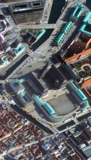


If you have never seen high off-nadir imagery before you are in for a treat this month! High off-nadir imagery means that the satellite’s camera was titled at a high angle (nearly 45 degrees) with respect to the ground when the data was captured, resulting in a side view of the landscape as opposed to top-down. And wow, these images are just fun! These five colorful views of Copenhagen, Denmark were collected on March 25, 2017 by WorldView-4 at an average resolution of 52-centimeters. Admittedly spring is not the best time to image this far north given how low the Sun is in the sky, but as Copenhagen is cloudy, we were happy to find this cloud-free, high off-nadir view. These WorldView-4 images have been resampled and enhanced by Apollo Mapping for improved colors, clarity and perspective. (Images Courtesy: Maxar)
Every time we look at WorldView-3 and WorldView-4 (WV3/4) imagery, we are blown away. And we hope you are equally impressed with the data! For the August 30-cm Color WorldView-3/4 Image of the Month we checked out the ‘view’ from the fourth tallest tower in the world, and for this month we travel to Europe with a look at high off-nadir imagery – or a high tilt angle of the camera in relation to the ground below – which lends a unique view of Copenhagen, Denmark. Oh and since these are big images at a different angle, we feature thumbnails only to the right but when you click on the images, you will see them in full resolution!
PLEASE NOTE: Effective May 2016, WorldView-3/4 prices dropped again! Are you interested in finding out more about these price drops? If so, send us an email at sales@apollomapping.com.
WorldView-3 launched in late 2014 and WorldView-4 launched in late 2016; taken together they are the most advanced satellite constellation the commercial marketplace has ever had access to. Here are a few of the features that really set these satellites apart from the competition:
- Improved Resolution
- Higher resolution means you can see more detail in WV3/4 imagery.
- Data collected at nadir will have 31-centimeter (cm) panchromatic, 1.24-meter (m) visible and near infrared, 3.7-m SWIR (WV3 only) and 30-m CAVIS (WV3 only) bands.
- At 20 degrees off-nadir, the resolution is 34-cm panchromatic, 1.38-m visible and near infrared and 4.1-m shortwave infrared.
- Additional Spectral Bands
- If spectral analysis is part of your project, then no other satellite can match WV3 with its: 8 bands of visible and near-infrared data; and 8 shortwave infrared bands which are crucial for geological studies.
- Better Positional Accuracy
- With accuracies of 3.5-m CE90% or better (without ground control even!), WV3/4 has no rivals for its enhanced positional accuracy.
- Daily Revisits
- At 40 degrees latitude, WV3 is able to image every location daily with 1-meter or better resolution and then every 4.5 days at 34-cm resolution or better.
- WV4 is no longer collecting new imagery.
- Increased Collection Capacity
- WV3/4 feature 13.1-km swath widths (at nadir) with the ability to collect up to 680,000 square kilometer (sq km) of high-resolution data per day per satellite (though WV4 is dead now).
- Improved control movement gyros translate into larger maximum contiguous collection areas per pass, with up to ~7,500 sq km of mono imagery and ~3,000 sq km of stereo possible.
If you are interested in WorldView-3 and/or WorldView-4 imagery for your next project, please let us know by phone, 303-993-3863, or by email, sales@apollomapping.com.
You can also find more WV3 samples and technical information on our website here and then WV4 samples and information can be found here.

Leave a Reply