
In November, we looked at Venice, Italy. This month for the Pléiades 1 – Pléiades Neo Point of Interest, we’re travelling to the Netherlands to explore the super cool Fort Bourtange!

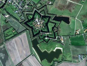
These two images feature Fort Bourtange. They showcase the beautiful, symmetrical star shape of the fortress that was so effective at keeping those within the village safe from attacking forces. Image one is a 50-cm photo was captured by Pléiades 1B on July 23, 2018. The second is a 30-cm image captured by Pléiades Neo on April 19, 2023. These images have custom processing and color balancing applied by Apollo Mapping. PLEIADES © CNES 2023, Distribution Airbus DS.
About the Point of Interest: Fort Bourtange, nestled in the picturesque countryside of Netherlands, is a captivating historical gem. Constructed in 1593 during the Eighty Years’ War, this star-shaped fortress served as a defensive bulwark against Spanish forces. Today, it stands as a beautifully preserved living museum, offering a fascinating glimpse into the past.
Fun Factoids: (1) Fort Bourtange blocked the sole road through an area that was once exclusively marshland. As the fort was expanded, water from the marsh was channeled into moats and used for farming irrigation. (2) The town houses a traditional windmill and wooden structures hanging over the moat that were used as toilets. (3) The five-sided shape of the fort, a design that originated in Italy, was constructed to give those inside the fort a panoramic view of oncoming attackers as well as an opportunity to attack forces from the front and their flanks. (4) The historical museum within the fort contains a 19th Century synagogue that was a place of worship for local Jews before Adolf Hitler’s invasion. (5) One of the most famous battles that occurred at Fort Boutange was that of the 1672 invasion by the German Bishop of Münster. Thanks to the marshes surrounding the Fort, the invading army was successfully deterred.
The 50-cm Pléiades 1 High-Resolution Satellite Constellation
The Pléiades 1 constellation (or at least part of it!) has been in orbit since December 2011 and if you have not had a chance to check out any sample imagery, take a few moments and have a look at the gallery on our website. If you work with high-resolution imagery, you should consider Pléiades 1 and Pléiades Neo for your next geospatial projects.
A variety of Pléiades 1 products are available from both a well-established archive and as a new collection, including 50-centimeter (cm) pansharpened imagery and 50-cm panchromatic – 2-meter (m) 4-band multispectral bundles. We are happy to discuss the technical specifications, pricing and tasking options available with both of these satellite constellations.
The 30-cm Pléiades Neo High-Resolution Satellite Constellation
Pléiades Neo is our newest high-resolution satellite constellation. The first Neo satellite went up in April 2021 and the second in August of the same year. This 30-centimeter resolution constellation will add two more satellites in the next few months and upgrade from daily to intraday revisits. Pléiades Neo has six multispectral bands with 1.2-meter resolution, including a deep blue and two infrared bands, along with a 30-centimeter resolution panchromatic band.
The archive is growing every day, and the satellites are available for new collections, making Pléiades Neo the perfect solution for site monitoring. Check out our beautiful sample images in the Pléiades Neo gallery.
More sample images and technical information about Pléiades 1 can be found on our website here; while the same can be found here for the Pléiades Neo constellation.
The Apollo Mapping sales team can answer any questions you might have about Pléiades 1 and/or Pléiades Neo. We can be reached at (303) 993-3863 or sales@apollomapping.com.

Leave a Reply