
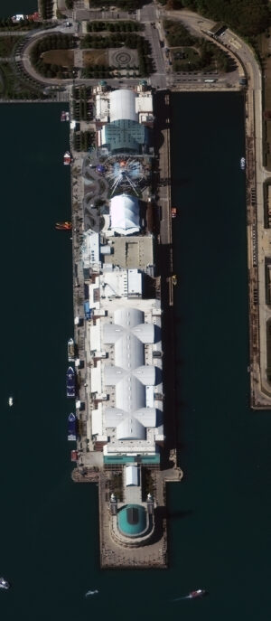
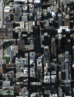
In our first images featured in this new monthly series, we have two bird’s eye view satellite images collected by WorldView-3 over Chicago, IL, USA on October 8, 2017. In these about 52-centimeter satellite images, you can see Chicago’s Navy Pier and then its tallest skyscraper, the Willis Tower. We hope you enjoy these high off-nadir satellite image samples! (Satellite Imagery © 2026 Vantor)
Welcome to our new monthly feature, The Bird’s Eye View! Each month, we’ll feature a new bird’s eye view satellite image from a select location around the globe; and for this month, we head to the home of the skyscraper, Chicago, Illinois, USA.
What Is Bird’s Eye View Satellite Imagery?
Well, that’s a good question we are happy to answer! When a satellite images the ground below it, there’s always some tilt to the camera as it looks down. This tilt is called off-nadir and is measured in degrees from 0; and so, it follows that 0° off-nadir means that the satellite is pointing directly down at the ground when it images, while a 90° off-nadir would mean that the satellite is pointing to the side and not even at the ground below it when it images. The vast majority of satellite imagery is collected with an off-nadir below 30°. However, in rare occasions, be it by a customer request, or to capture a natural disaster or other important event, a satellite can tilt and image in the range of 35° to 50° which we consider ideal for a high off-nadir imagery, also called bird’s eye view imagery. These bird’s eye view images lend a unique perspective to satellite imagery that is an expansive view of the landscape from the side. We hope you enjoy the bird’s eye view satellite imagery that we share in this article. And if you have any questions about this type of data or any of the imagery products we can help you with, send us an email at any time to sales@apollomapping.com!
If you are interested in additional bird’s eye view satellite images from this location, head over to our Reddit subgroup, BirdsEyeViewImagery, and become a member. We post high off-nadir satellite imagery every Friday in the BirdsEyeViewImagery subgroup.

Leave a Reply