
In this monthly feature, we span the globe to examine Our Changing Landscape with time series of medium resolution RapidEye satellite imagery. The RapidEye archive dates back to late 2008 and already contains more than 3 billion square kilometers of data. This month, we look at an issue that we know rather personally with our Boulder, Colorado office – the Mountain Pine Bark Beetle (MPB) outbreak.
The RapidEye Constellation
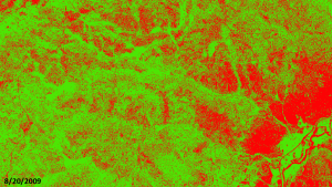
RapidEye is a constellation of five 5-meter medium resolution satellites each offering five spectral bands of information. The RapidEye constellation offers a daily revisit time to every location on the planet with a huge footprint that is 77-km wide. The data is priced competitively with a base price of $1.28 per square kilometer for all five spectral bands – academics do receive discounts. RapidEye adds a fifth band, the red edge, to the ‘traditional’ multispectral set of blue, green, red and near-infrared (NIR). The additional spectral data available in the red edge band allows users to extract more useful land ‘information’ than can be from traditional 4-band imagery sources. When RapidEye imagery is ordered as a Level 3A Orthorectified product, images from multiple dates are extremely well registered, making it the ideal data source for Our Changing Landscape.
The Mountain Pine Bark Beetle Outbreak
Mountain pine beetle, Dendroctonus ponderosae, is a native to the forests of western North America and periodic outbreaks mark the ecological record of the region. During an outbreak, MPB target ponderosa, lodgepole, Scotch and limber pine, starting with older, stressed and injured individuals and then spreading to all trees once the epidemic is full-blown. It is also not uncommon for related beetles to target other pine species in the dying forest. 8 to 10 months after a tree is infected, its foliage turns yellow to reddish as it succumbs to MPB. In the cold winter months, MPB larvae breakdown glycerol to protect from freezing.
The current MPB outbreak is the worst on record with more than 41.7 million acres infected across the western United Stated and Canada since it started in 1997. This outbreak appears to be exacerbated by the convergence of environmental and social pressures. Since the start of the 2000s, there has been an extended drought across much of western North America which many link to Global Climate Change – regardless of the cause of the drought, trees in droughty conditions are more stressed and this makes them more susceptible to a MPB infection. Further, the winters have been warmer so larvae which may have succumbed to extended periods of cold weather survived. These environmental stresses are conflated by commonly employed forest management techniques in the West which reduce the occurrence of natural fires (often important to maintaining healthy forest stand dynamics) and thus encourage denser forest stands. Denser forest are prime targets for a rapidly-spreading MPB outbreak.
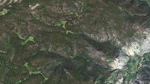
A natural color look at our area of interest in Roosevelt National Forest, Colorado. This 5-meter RapidEye image was collected 8/20/2009.
The Front Range of Colorado and southern Wyoming have been particularly hard hit by the MPB outbreak. Since 1996, the United States Forest Service estimates that 6.6 million acres in Colorado and 3.65 million acres in Wyoming have been impacted. In this edition of Our Changing Landscape, we look at a the spread of MPB in a rural section of the Roosevelt National Forest – a secluded Colorado forest stand along the Front Range of the Rocky Mountains.
If you would like to find out more about using RapidEye for your academic studies, engineering projects or any landscape analysis, let us know at sales@apollomapping.com or (303) 993-3863.

Leave a Reply