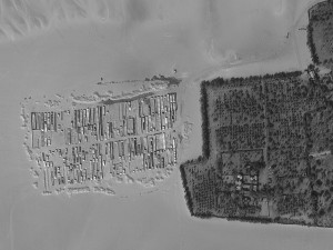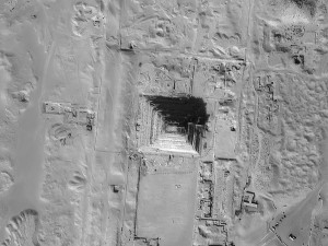


A series of 68-cm panchromatic EROS B images collected outside Saqqarah, Egypt on February 23, 2013. (Image Source: ImageSat International)
Do you need high resolution imagery now?! And at a price that will not break the bank?
If so, you need to consider EROS B for your next geospatial project. With the lowest minimum order price for a new collection of high resolution satellite imagery, EROS B is a viable solution for those in need of rapid tasking. The tasked imagery is budget friendly with a guaranteed collection within 7 days of order confirmation anywhere on the planet!
EROS B delivers panchromatic-only imagery to assure maximum tasking capacity and thus quicker collections of new data. For our readers who have not worked with panchromatic imagery, it is an excellent substitute for any project that requires natural color data. Admittedly, if your project includes spectral analysis that relies on multispectral bands, then EROS imagery is not an appropriate choice.
Here are some instances where panchromatic EROS B imagery is an ideal choice:
- Regional mapping projects
- Site monitoring over remote construction sites
- Creating elevation models where project timelines are short
- Planning a demographic survey before you arrive on site
- Updating a GIS database with current imagery over high growth areas
- Collecting new imagery over areas that traditionally have high competition
Key Specifications of EROS B
- Launch Date – April 25, 2006
- Spectral Bands – panchromatic only
- Resolution – ~70 centimeter (varies with orbital height, off-nadir angle and imaging mode)
- Revisit Time – ~3.5 days (varies with latitude and off-nadir angle)
- Swath Width – 7 km (varies with orbital height and off-nadir angle)
- Bit Depth – 10-bits
- Average Orbit Height – 510 km
For more information about EROS B, pricing requests or tasking feasibilities, please contact the Apollo Mapping sale team at sales@apollomapping.com.


Leave a Reply