
In this monthly feature, we span the globe to examine Our Changing Landscape with a time series of medium-resolution PlanetScope satellite imagery. The PlanetScope constellation dates back to 2016 and collects hundreds of millions of square kilometers of four and eight-band 3-meter imagery daily! In June, we checked out the 2024 edition of the Bonnaroo Festival, which ran from June 13th to 16th with artists performing on more than 10 stages. For the July edition of this series, we are looking at the 7.7 earthquake in Myanmar that hit the area on March 28, 2025.
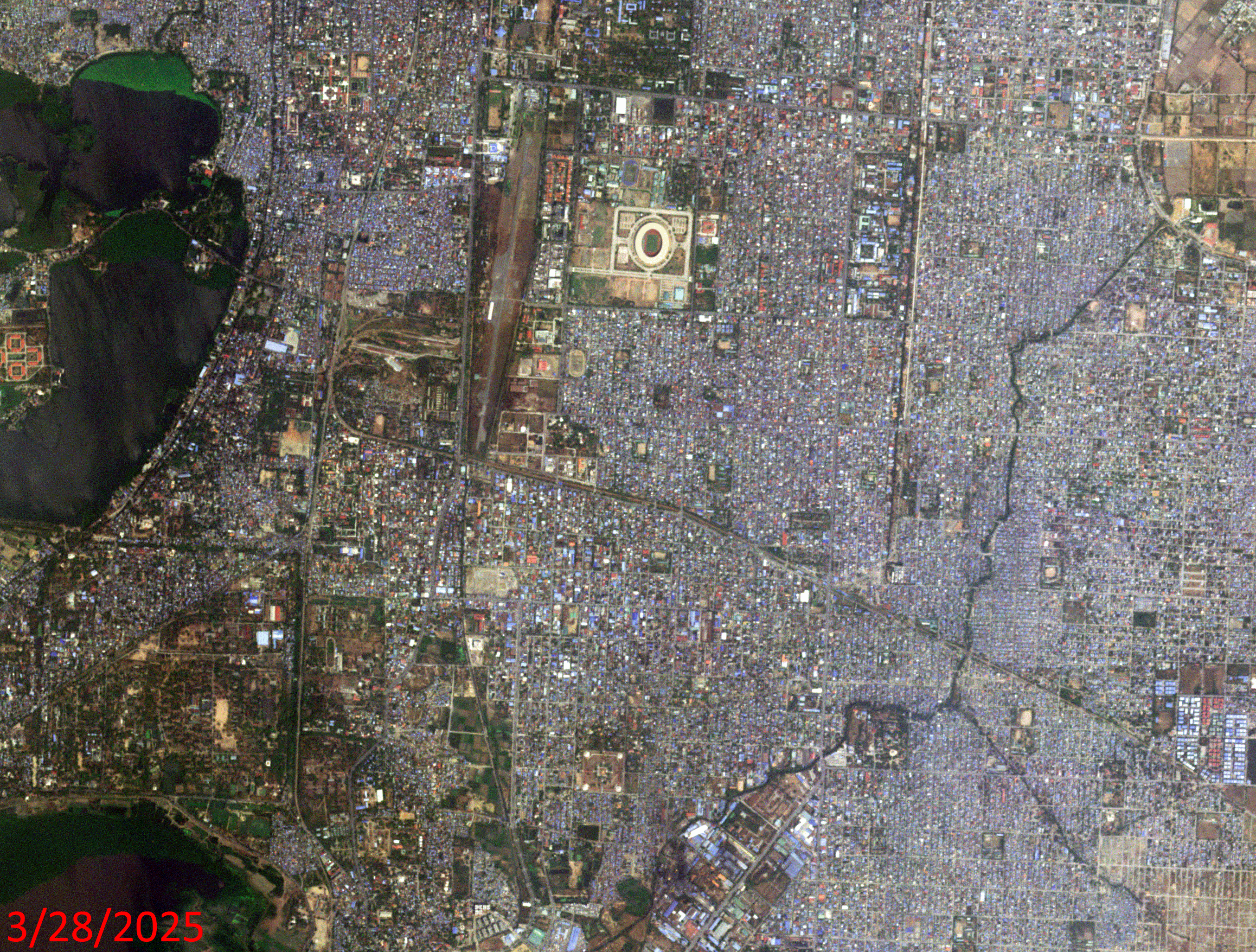 Click on the image above to see an animation of 3-meter natural color PlanetScope image collected over Mandalay, Myanmar on March 28 and 29, 2025. In this animation, we actually capture Mandalay the day of the 7.7 magnitude earthquake just hours before it struck – very sad indeed; as in the March 29th image, even at 3-meter resolution, the extent of the destruction is obvious. In the third slide, we circled a region to track in the animation to see the extent of the destruction. Our hearts are with the nation of Myanmar as they grieve and recover from this major disaster. (Images Courtesy: © Planet 2025)
The PlanetScope Microsat Constellation
PlanetScope is a constellation of more than 240 microsats referred to individually as Doves. Each Dove is able to collect up to 20,000 square kilometers (sq km) per day of 3-meter (m) 4-band multispectral (i.e. blue, green, red and near-infrared [NIR]) imagery; and newly launched SuperDoves collect 8-band multispectral adding in valuable red-edge spectral data. Across the constellation, PlanetScope is archiving more than 200 million sq km of medium-resolution imagery a day, making it the go to source for daily imagery over most locations. This massive archive dates back to 2016, offering the most complete and continuous record of spatial data on the planet since the start of the constellation’s ongoing launch schedule. Collecting 3-meter multispectral imagery is the equivalent of ‘high-resolution’ multispectral data imaged by a 75-centimer (cm) satellite (as this satellite would feature 75-cm panchromatic and 3-m multispectral), making PlanetScope an extremely competitively priced option at just $2.25 per sq km. With well registered images and nearly daily collections of most locations, PlanetScope is the ideal imagery source for this current-events focused series, Our Changing Landscape.
March Earthquakes In Myanmar
More than 3,000 people died and another 4,500 were injured when a 7.7 magnitude earthquake rattled Myanmar on March 28, 2025. The earthquake was so strong that it could be felt in Thailand and southwest China, according to the BBC.
The epicenter of the earthquake was near the country’s second largest city, Mandalay. The first tremor could be felt around 12:50 p.m. followed by a second earthquake 12 minutes later that registered 6.4. Aftershocks continued to ripple for days, even reaching magnitudes of 5.1. A little more than 600 miles away, a high-rise building in Bangkok toppled because of the earthquake, the BBC reported.
The damage caused by the earthquakes could be seen in the buckled roads, damaged bridges and flattened buildings. A state of emergency was declared in the six most damaged regions. People were trapped for days and searchers dug through rubble with bare hands to try and unearth them, reported the BBC. Hundreds of people remained missing in the days following the earthquake.
Two months later, on May 6th, 10 mild earthquakes with magnitudes ranging from 1.3 to 3.0 were recorded in Myanmar as well as in northern and northeastern Thailand in the morning, according to the Thai Meteorological Department.
The earthquakes arrived at a time when the war-struck region was already struggling. Four years of war has ravaged Myanmar; 3 million people have been displaced by the fighting and the earthquake has only deepened an already dire humanitarian crisis in which at least 20 million people need aid, according to CNN.
If you would like to find out more about using 3-meter PlanetScope imagery for your academic studies, engineering projects or any landscape analysis, let us know at sales@apollomapping.com or (303) 993-3863.

Leave a Reply