
In this monthly feature, we span the globe to examine Our Changing Landscape with time series of medium resolution RapidEye satellite imagery. The RapidEye archive dates back to late 2008 and already contains more than 7 billion square kilometers of data. For March, we focus our attention on Lake Poopo, Bolivia, an environmental tragedy in the making.
The RapidEye Constellation
RapidEye is a constellation of five 5-meter medium resolution satellites each offering five spectral bands of information. The RapidEye constellation offers daily revisits to every location on the planet with a huge footprint that is 77-km wide. The data is priced competitively with a starting cost of $1.28 per square kilometer for all five spectral bands – academics do receive discounts. RapidEye adds a fifth band, the red edge, to the ‘traditional’ multispectral set of blue, green, red and near-infrared (NIR). The additional spectral data in the red edge band allows users to extract more useful land ‘information’ than can be from traditional 4-band imagery sources. When RapidEye imagery is ordered as a Level 3A Orthorectified product, images from multiple dates are extremely well registered, making it the ideal data source for Our Changing Landscape.
The Disappearance of Lake Poopó, Bolivia
Lake Poopó was Bolivia’s second largest lake, located some 12,090 feet above sea level, the shallow, saline lake covered 977 square miles at its average low point, measuring about 56 miles by 20 miles. With depths ranging from 8 to 18 feet, Lake Poopó was an important ecological resource for both the local residents as well as the local flora and fauna of the Altiplano Mountains in southwest Bolivia. Archeological evidence suggests permanent, subsistence-based human populations have been found in the region since about 200 BCE. Lake Poopó was also home to at least 75 bird, 14 plant and 3 algae species.
Now as you might have noticed pretty quickly, we are talking about Lake Poopó in the past tense as in December 2015, it was reported that the lake had all but completely disappeared! Given that the lake is located at a high elevation in an arid region, it was not uncommon for the lake’s levels to fluctuate greatly during the season, with levels rising during the rainy months of December to March. However, in 1995, the first warning signs of the impending doom of Lake Poopó were apparent when the lake dried up in December. Increased rainfalls in the mid to late 1990s replenished the lake but in the recent years, the lake’s waters were receding dramatically again. In fact, in 2013, the German consortium of Gitec-Cobodes predicted the demise of the lake when it found Poopó received 4.2 billion fewer gallons of water than were required to maintain it.
While Lake Poopó has come and gone in the past, many scientists think this time it may be gone for a long time as there are multiple environmental pressures on the region that compound one another. First, the Oruro Department of Bolivia is a mining region with at least 100 mines that are upstream of the lake. For many years, environmentalists have shown that heavy metals from the mine were trapped in the sediment deposited into the lake by its feeder streams. These sediments were not only toxic but they also choked out the ecosystem as the lake’s bottom rose off its original surface. Second, much of the water that once feed the lake has been diverted for both use in mining as well as for irrigation. Next, there is the pressure of global climate change which has increased local temperatures by about 1.6 degrees Fahrenheit; and higher temperatures means quicker evaporation of the lake’s waters. Finally, with climate change there has been an increase in both the frequency and severity of El Niño events which brings drought conditions to the region around Lake Poopó.
No one knows what the future will hold but the loss of this important ecological resource should concern climate change deniers and supporters alike. But regardless of your views on climate change, now it is time to turn to the 5-meter RapidEye record over Lake Poopó to see how its water levels have fluctuated in recent years.
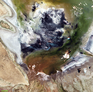 Click on the image above to see an animation of 5-meter natural color RapidEye imagery collected over Lake Poopo, Bolivia on February 12, 2010, December 1, 2012, February 4, 2014 and January 9, 2016. When you click on this animation you might first notice how different the lake and surrounding lands look from year to year. But more importantly, you will see little change in the water level from 2010 to 2014; and then in 2016, you see that the lake is completely gone, scary stuff folks. And please excuse the cloud cover and missing data as this was a large area with few images collected close in time to each other, so we had to make do! To give you a sense of the scale, these images measure about 22 kilometers x 22 kilometers. (Images Courtesy: BlackBridge)
If you would like to find out more about using RapidEye for your academic studies, engineering projects or any landscape analysis, let us know at sales@apollomapping.com or (303) 993-3863.

Leave a Reply