

In this monthly feature, we span the globe to examine Our Changing Landscape with a time series of medium-resolution PlanetScope satellite imagery. The PlanetScope constellation dates back to 2016 and collects hundreds of millions of square kilometers of four and eight-band 3-meter imagery daily! In August, we indulged in the beautiful bluebonnets’ blooming in Brenham, Texas. For the September edition of this series, we travel to Gressan, Italy and Stage 14 of the Giro d’Itaia.
Do you enjoy the high-resolution satellite imagery we post monthly in this article and elsewhere in The Geospatial Times? If so, head over to our Reddit subgroup, HighResSatelliteImage, where we post some our favorite high-resolution satellite images on a weekly basis.
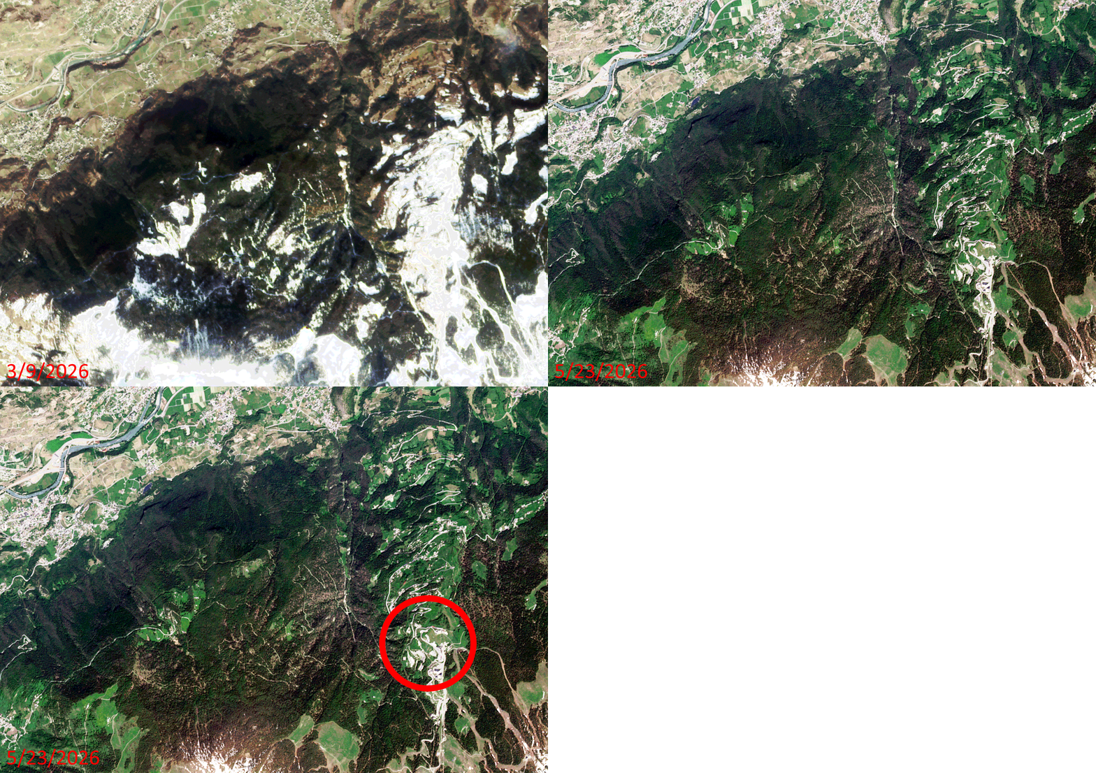 Click on the image above to see an animation of 3-meter natural color PlanetScope image collected over the Gressan, Italy region on March 9 and May 23, 2026. In this animation, you can see how much snow melted in the Alps here when spring arrived and the temperatures started to climb. You can also see how much greenery springs back to life once the rains arrive and the snow melts. But equally as ‘important’ is the circled area in the May 23rd image which is where Stage 14 of the Giro d’Italia came to an end with Jonas Vingeaard riding solo up the summit of Pila where he beat runner-up Felix Gall by 49 seconds. (Images Courtesy: © Planet 2026)
The PlanetScope Microsat Constellation
PlanetScope is a constellation of more than 240 microsats referred to individually as Doves. Each Dove is able to collect up to 20,000 square kilometers (sq km) per day of 3-meter (m) 4-band multispectral (i.e. blue, green, red and near-infrared [NIR]) imagery; and newly launched SuperDoves collect 8-band multispectral adding in valuable red-edge spectral data. Across the constellation, PlanetScope is archiving more than 200 million sq km of medium-resolution imagery a day, making it the go to source for daily imagery over most locations. This massive archive dates back to 2016, offering the most complete and continuous record of spatial data on the planet since the start of the constellation’s ongoing launch schedule. Collecting 3-meter multispectral imagery is the equivalent of ‘high-resolution’ multispectral data imaged by a 75-centimer (cm) satellite (as this satellite would feature 75-cm panchromatic and 3-m multispectral), making PlanetScope an extremely competitively priced option at just $2.25 per sq km. With well registered images and nearly daily collections of most locations, PlanetScope is the ideal imagery source for this current-events focused series, Our Changing Landscape.
Gressan, Italy and the Giro d’Italia
Gressan is a picturesque town situated in Italy’s northwestern Aosta Valley. Located just 5 km from Aosta, it serves as a spectacular alpine base, seamlessly blending serene nature in the valley with world-class skiing and hiking at the neighboring mountain resort of Pila.
The top attractions in Greesan include the Pila Ski Resort, which offers downhill skiing, snowboarding, and a fun park in the winter. There’s also Chamole Lake, a pristine alpine lake perfect for summer hiking and nature viewing. Gressan Green Area happens to be a sprawling park based at the foot of the town that features cycling paths and scenic walking trails.
Gressan also happens to be a stop along the Giro d’Italia, a prestigious pro cycling Grand Tour race. The 109th edition of the race ran May 8 to May 31 this year. Stage 14 of the race rode through Gressan ending on the slopes of Pila, a local ski resort.
If you would like to find out more about using 3-meter PlanetScope imagery for your academic studies, engineering projects or any landscape analysis, let us know at sales@apollomapping.com or (303) 993-3863.


 Copyright © 2025 All Rights Reserved -
Leave a Reply