

In this monthly feature, we span the globe to examine Our Changing Landscape with a time series of medium-resolution PlanetScope satellite imagery. The PlanetScope constellation dates back to 2016 and collects hundreds of millions of square kilometers of four and eight-band 3-meter imagery daily! In July, we were over Vulkan Krenityna in Sakhalin Oblast, Russia. For the August edition of this series, we head to the USA to check out bluebonnets blooming in Brenham, Texas.
Do you enjoy the high-resolution satellite imagery we post monthly in this article and elsewhere in The Geospatial Times? If so, head over to our Reddit subgroup, HighResSatelliteImage, where we will post some our favorite high-resolution satellite images on a weekly basis.
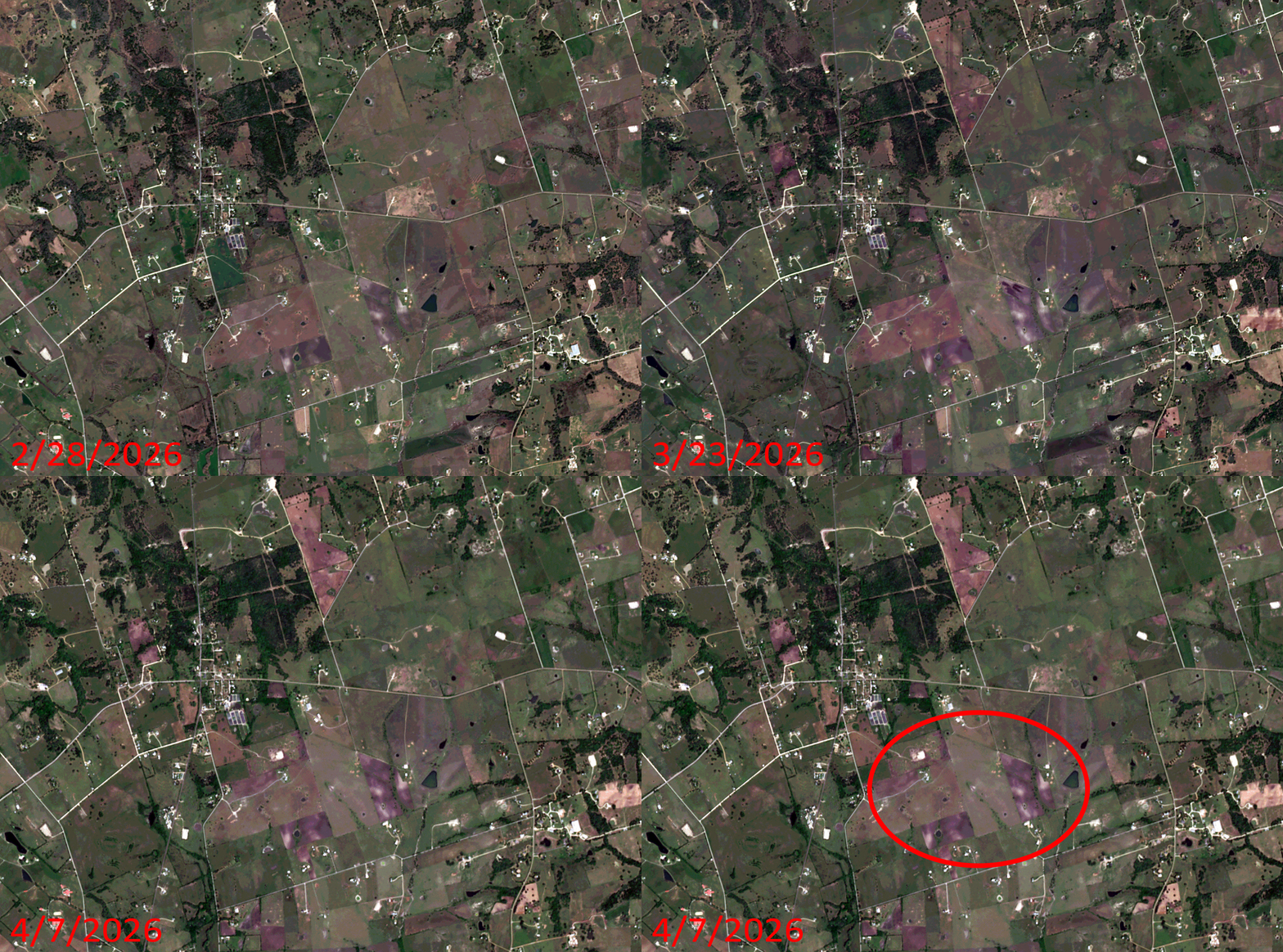 Click on the image above to see an animation of 3-meter natural color PlanetScope image collected over Brenham, Texas on February 28, March 23, and April 7, 2026. In this animation, you can see green return to this arid landscape in the March 23rd image and then by April 7th, the bluebonnets return, lending a purple hue to multiple fields in and around Brenham. In the final slide, we have circled a region to focus on where you can really see the bluebonnet fields coming alive with color. (Images Courtesy: © Planet 2026)
The PlanetScope Microsat Constellation
PlanetScope is a constellation of more than 240 microsats referred to individually as Doves. Each Dove is able to collect up to 20,000 square kilometers (sq km) per day of 3-meter (m) 4-band multispectral (i.e. blue, green, red and near-infrared [NIR]) imagery; and newly launched SuperDoves collect 8-band multispectral adding in valuable red-edge spectral data. Across the constellation, PlanetScope is archiving more than 200 million sq km of medium-resolution imagery a day, making it the go to source for daily imagery over most locations. This massive archive dates back to 2016, offering the most complete and continuous record of spatial data on the planet since the start of the constellation’s ongoing launch schedule. Collecting 3-meter multispectral imagery is the equivalent of ‘high-resolution’ multispectral data imaged by a 75-centimer (cm) satellite (as this satellite would feature 75-cm panchromatic and 3-m multispectral), making PlanetScope an extremely competitively priced option at just $2.25 per sq km. With well registered images and nearly daily collections of most locations, PlanetScope is the ideal imagery source for this current-events focused series, Our Changing Landscape.
Bluebonnet Blooms in Brenham, Washington County, Texas
As spring arrives in Texas, the state’s official flower begins to bloom. And like everything in Texas – even the bluebonnets are bigger than everywhere else. Known as the bluebonnet capital, Brenham, Texas, sits in the middle of bluebonnet country. During Spring, the town transforms into a sea of blue and becomes part of the popular Texas Bluebonnet Trail.
There’s wildflower etiquette guests are encouraged to follow when checking out the bluebonnets, as well as perfect places to picnic, so they can make it a full day. The interactive wildflower driving map changes every year, but helps guide locals and guests alike as they embark upon their bluebonnet adventure.
Bluebonnets are annual plants, completing their entire life cycle – from germination, to flowering, seeding, and finally dying – within a single season. While they are predominantly blue, though occasionally they bloom in shades of white, pink, and maroon due to genetic variations. There’s even a Facebook page dedicated to the various blooming stages of bluebonnets in Washington County to help floral enthusiasts know when to hit the trail and soak in their beauty.
If you would like to find out more about using 3-meter PlanetScope imagery for your academic studies, engineering projects or any landscape analysis, let us know at sales@apollomapping.com or (303) 993-3863.


 Copyright © 2025 All Rights Reserved -
Leave a Reply