
This month we made major strides forward with Map Mavin’s user interface. In fact, we made enough progress to feel comfortable sharing two screengrabs with you. Before you check these out, please keep in mind that these interfaces will still see significant overhauls, but we think they are still pretty cool as they are now!
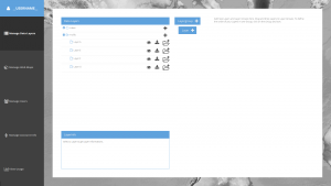
The sneak preview of Map Mavin below shows you the first step of making a web maps which is loading your project’s spatial layers such as shapefiles, KMZs and TIFFs. This interface lets you group your spatial layers in folders, download them from the cloud and view their metadata.
The second screengrab from Map Mavin shows the interface for publishing web maps. Here you can set your web map’s name, offer it a description and make it public or private among many other options. We also plan on adding directions to each interface, making your user experience that much easier!

While we are busy building out the infrastructure and technology required to support the most flexible GIS cloud on the market, now is a great time to explain a bit about the Map Mavin.
Some of you may have used other GIS cloud services in the past, and in many ways the Map Mavin will be similar to these. But the Map Mavin will distinguish itself in a variety of important manners. Here is a list of the key features that will be unique to the Map Mavin:
- Near-instant set-up – unlike other GIS clouds, the Map Mavin will take less than five minutes to sign up for, load data on to and get started using. No other cloud comes close to that flexibility.
- Tons of free spatial data – included with every subscription is access to more than 4 terabytes (TB) of free vector and raster data covering the United States and many parts of the world.
- A marketplace for spatial data – all users will have access to a library of spatial data that can be added to your GIS cloud. Further, users will be able to post data they have created to the marketplace to sell to other users (or let them use for free if you wish).
- Cloud computing – we will ask all users for feedback on the spatial operations they perform most frequently and will then implement the most popular ones in the Map Mavin.
- Free entry-level subscriptions – users will be able to use the full-functionality of Map Mavin with a free 30-day demo or up to 5 megabytes of storage. And once you pass this storage limit or 30 days of usage, subscriptions will start at just $10.00 per month!
- A robust online viewer – for those users in your organization lacking access to a GIS application, the Map Mavin will feature an online viewer that can be accessed from anywhere in the world as long as users have internet access.
- Enhanced browsing speeds – we will have all of your spatial data cached in multiple locations around the world so access times will be greatly reduced for international users.
- Flexible streaming architecture – administrators will be able to setup multiple WMS and WFS feeds that can be shared with the appropriate teams of data users. Each feed can be seeded with the datasets these users need access to.
- Industry-leading data redundancy – with 99.999999999% data redundancy, you can be assured that your data will not be lost once placed on the Map Mavin.
Do you have any specific questions you would like answered about the Map Mavin? Or perhaps you want to join the beta program? If so, let us know by email at sales@apollomapping.com.

Leave a Reply