
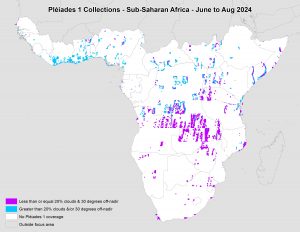
 This map shows the areas imaged by the Pléiades 1 constellation from June 1 to August 31, 2024 over Sub-Saharan Africa. Please note that in many instances, multiple images were collected over the same area which is difficult to portray on this static map.
In this monthly piece, we give our readers a sense of the high-resolution imagery coverage collected over a geography during a specified window. To do this, we pick a high-resolution satellite constellation, a defined time period and area of interest, then we report key statistics on the total amount of imagery collected in square kilometers (sq km). Without further delay, let’s jump into our analysis.
Graphic Region of Interest: Sub-Saharan Africa plus off-shore islands
Land Mass Covered: 16,510,458.9 sq km
Time Period: June 1 to August 31, 2024
High-Resolution Satellite Constellation: Pléiades 1A/1B
Pléiades 1 Constellation Imaging Statistics – Sub-Saharan Africa
Total Area Collected: 2,163,616.5 sq km; 11,758.8 sq km per satellite/per day
Area Collected @ 20% or Less Clouds & 30 Degrees or Less Off-Nadir: 955,850.6 sq km; 5,194.8 sq km per satellite/per day; 44.18% of total

Leave a Reply