
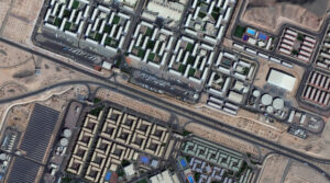
 A 30-cm WorldView Legion image courtesy of Maxar collected over the NEOM Campus in Saudia Arabia on December 2, 2024. Apollo Mapping has applied custom color balance and image enhancements.
We are very excited to announce that the final two satellites in the 30-centimeter (cm), 8-band WorldView Legion constellation are live as welcome both Legion 5 and Legion 6 to Image Hunter! With six 30-cm satellites in orbit, this constellation adds an impressive 3.2 million square kilometers of high-resolution satellite imagery to Image Hunter every single day, wow. Further, with industry-leading 8-band multispectral imagery, WorldView Legion is ready to tackle your next geospatial project, even if spectral analysis is the need.
With six active satellites in orbit, the WorldView Legion constellation sets itself apart with these unique specifications:
- A six-satellite constellation with four middle-orbit (MIO) satellites.
- 30-cm panchromatic band plus 1.2-meter (m) 8-band multispectral including coastal, blue, green, yellow, red, red edge 1, red edge 2, and near-infrared (NIR).
- Each satellite in the constellation images over 500,000 sq km per day.
- The WorldView Legion constellation averages 3 accesses per day to locations between 40° North and South latitudes.
- With four MIO satellites, WorldView Legion images throughout the day, not just during the morning as most satellite systems do.
If you would like to find out more about using 30-cm WorldView legion for your next mapping and/or remote sensing project, you can send us an email at anytime to sales@apollomapping.com.
Or you can query the entire 30-cm WorldView Legion archive at anytime on Image Hunter!

Leave a Reply