
In April, we looked at beautiful Tofo Beach in Mozambique. This month for the Pléiades 1–Pléiades Neo Point of Interest, we check out downtown Los Angeles, which is where the Fiesta Broadway is held.
About the Point of Interest: Fiesta Broadway organizers tout their annual event as the world’s largest Cinco de Mayo. The 2025 event will take place in downtown Los Angeles on April 27 but with a new experience for guests. The street festival celebrates the city’s rich cultural diversity. Fiesta Broadway is known for its dynamic programming, featuring live music performances, dance shows, traditional folkloric displays, and a wide variety of food vendors serving up cuisine from various cultures. The event also provides a platform for local artists, artisans, and community organizations to showcase their talents and share their messages.

 These two satellite images show downtown Los Angeles from above where Fiesta Broadway filled the streets for Cinco de Mayo 2025! In the Pléiades 1B 50-cm color photo taken June 30, 2023, the satellite image reveals bold buildings with colorful dots of people. The second photo captured June 21, 2023 by 30-cm Pléiades Neo, shows another aerial view of the downtown area with people as small as ants, tents set up, and colorful parked cars. These images have custom processing and color balancing applied by Apollo Mapping. PLEIADES © CNES 2025, Distribution Airbus DS.
Fun Factoids: (1) In honor of Cinco de Mayo, Fiesta Broadway will offer a new attraction in 2025 called Fiesta Taco Fest, which pays homage to LA’s taco culture. (2) There also will be La Fiesta de los Moles, which celebrates the tastiness of mole from Mexico. (3) At the Pabellon de la Salud, there will be free health checkups and wellness tips offered. (4) The 2025 event also will feature fan favorites such as live performances on two stages, wrestling matches at Lucha Libre, and the popular Kids Play Zone. (5) The event draws thousands of attendees each year. (6) In 2019, Fiesta Broadway celebrated its 30th anniversary. But after COVID-19 halted the event in 2020, it returned in 2024.
The 50-cm Pléiades 1 High-Resolution Satellite Constellation
The Pléiades 1 constellation (or at least part of it!) has been in orbit since December 2011 and if you have not had a chance to check out any sample imagery, take a few moments and have a look at the gallery on our website. If you work with high-resolution imagery, you should consider Pléiades 1 and Pléiades Neo for your next geospatial projects.
A variety of Pléiades 1 products are available from both a well-established archive and as a new collection, including 50-centimeter (cm) pansharpened imagery and 50-cm panchromatic–2-meter (m) 4-band multispectral bundles. We are happy to discuss the technical specifications, pricing and tasking options available with both of these satellite constellations.
The 30-cm Pléiades Neo High-Resolution Satellite Constellation
Pléiades Neo is our newest high-resolution satellite constellation. The first Neo satellite went up in April 2021 and the second in August of the same year. This 30-centimeter resolution constellation will add two more satellites in the next few months and upgrade from daily to intraday revisits. Pléiades Neo has six multispectral bands with 1.2-meter resolution, including a deep blue and two infrared bands, along with a 30-centimeter resolution panchromatic band.
The archive is growing every day, and the satellites are available for new collections, making Pléiades Neo the perfect solution for site monitoring. Check out our beautiful sample images in the Pléiades Neo gallery.
More sample images and technical information about Pléiades 1 can be found on our website here; while the same can be found here for the Pléiades Neo constellation.
The Apollo Mapping sales team can answer any questions you might have about Pléiades 1 and/or Pléiades Neo. We can be reached at (303) 993-3863 or sales@apollomapping.com.
Shortly after Donald Trump won the presidency in 2016, I wrote an op-ed about three things in society that should’ve pointed towards Trumpism if not Trump himself. Instead of immediately submitting it to my local paper, it sat in the idle archives of my computer until I sent it to them shortly before the 2020 election with a slight update indicating if he won re-election, those reasons still stood and could be looked to for some insight if not a complete postmortem. Two of the factors came of age in the late 80s and early 90s, and the third in the early aughts, but all have swelled to become even more omnipresent today and have mutated significantly since their introductions: political correctness and the policing of language; reality television and our societal penchant for schadenfreude; and social media and its seemingly meth-fueled spin cycle and 24/7/365 flashing lights, blaring sirens, and strangers offering candy. Perhaps not that astute, but I don’t think it’s too hard to trace the trajectory of the decline of American culture and society from those three points of departure.
To say I was relieved when Trump lost in 2020 would be an understatement, not because I was a diehard Biden supporter, but because some return to normalcy was highly welcome, even though I openly acknowledge all the evils and perils that are baked into our government and its two major parties, Don the Demagogue aside. We weren’t returning to a perfect world, only one less fraught with dread, backwardness, and volatility. But as the 2024 election season snuck up on us, I had real worry, as Biden was clearly old and infirm, and the Democrats really hadn’t done well with their policies and messaging in the wake of the post-pandemic years and the inflation it wrought. I didn’t hold onto hope and I thought Biden would lose, and some of the nails in the coffin included the “debate,” the first assassination attempt, and the pick of JD Vance as VP (the latter being something I’ve changed my opinion on, particularly as it’s been consistently evidenced that he is not popular at all and is clearly a panderer and a sycophant lacking any authenticity or backbone). But I digress. I still thought Biden was dead in the water. I can’t say I felt much better about Harris at the top of the ticket, as she was never popular and always got chewed up in the media and couldn’t unravel herself from the criticisms, but I found some solace in the “left” rallying around her, even if in retrospect it’s clear that it was surface-level and all glitz and no glamor–skin deep support from “elites” and the Hollywood class, and the steep drop-off from there. With an inability to control the narrative on the border and inflation, and embracing the losing argument of the culture wars, defeat was almost guaranteed from the outset. That gets us about to where we are today.
 The dumpster fire has turned into a wildfire and I hope we have the water to contain it. (Image retrieved from here and comes courtesy of Pixabay.)
I wasn’t an “oppose Trump at all costs” kind of guy during his first term per se, though I generally disagreed with most of his positions, his behavior and lack of character, and his desire to destroy democracy and serve himself first and foremost. So, I guess I pretty much did oppose him, at least at most costs… In other words, I was not (and am not) a fan. But this time, I decided I wanted to approach his term a little differently–if possible–in that I’d weigh each decision made on its own merits. I figured this would keep me from overreacting or getting sucked into an echo chamber that made it harder to sort real from fake, good from bad, right from wrong, etc. Part of the reason for my attempt to approach it like this is something that gets brought up from time-to-time from different talking heads, and that is the simple fact that not every idea he has is bad, and that there is often a lot of truth in his lies and his bluster. Now, don’t get me wrong, I still think most of his behaviors and decisions are nothing short of terrible and will instill great harm on this country and its citizens, but there are some things he’s not entirely off-base on, it’s just that it almost always boils down to the simple fact that he goes about it all the wrong way.
So, here we are, a little over two months into the term (at the time of writing), and I’ll admit it’s a little challenging not to be dismissive of the whole shebang. I mean, putting it “politely,” it’s a shitshow. As was to be expected, and then some… But I’ll continue to try and hold sweeping judgment and just document a few things that are steaming my kettle–and to reiterate, “the left” has major issues, is full of opportunists and power-seekers, and genuinely engages in anti-democratic practices as well, just not to the extent of “the right,” and specifically under Dear Leader, Donald J. Trump. So, where do I begin?
I’m tempted to start with Gaza and his “plan” for the United States to take it over and turn it into “the Riviera of the Middle East,” permanently displacing those who live there currently (even if they’ve been displaced already by the ongoing war on their backyard). I thought he was “America first”? It’s going to take a lot of money, manpower, and resources to renovate and occupy that area. It just seems so half-baked…
Or maybe it’s better to begin with the firing of tens of thousands of federal workers and the closing or drastic downsizing of the agencies they work for. I’m all for efficiency and eliminating redundancies, as well as maximizing taxpayers’ contributions to the country. But this is reckless and cruel. I must assume some of these people he’s letting his avatar, Elon Musk, axe voted for him. It’s clear that there will be significant ripple effects of these decisions on the communities where those people reside, not to mention their families. The directive is to go work in the private sector. Is it so easy? Are equivalent jobs available? Just to choose one segment greatly affected that really got me are the land management agencies, like the NPS and USFS. Are they aware of how much pass-through tourism dollars come to small businesses and local communities from people visiting the parks and forests every summer? Do they care how much our collection of beautiful and ecologically rich wilderness areas will be permanently impacted from no management or conservation efforts? I thought The Don was for the everyman. These types of federal jobs are about as blue collar as they get…
Or maybe we should really shine the light on his siding with dictators, like Putin, and his tendencies towards dismantling generations-old relationships with our allies, like Canada, France, Germany, and the UK. It’s clear he’s never understood or cared about the value of relationships, loyalty, or collaboration, as his failed and crooked business empire has demonstrated over the decades. But is he at least aware that we’re weaker without these relationships maintained?
Perhaps we begin with the elimination of USAID or the Consumer Financial Protection Bureau–the former which helps us keep trouble at bay and dampen anti-American sentiment abroad, the latter which protects individuals–many of them his voters–from being taken advantage of and bankrupted by large corporations. But Donald has never really cared about anyone other than himself. He just aims to grab more power and more money for his name, brand, and legacy, collateral damage be damned.
Or maybe we start with the recent kerfuffle of the leaked chats from the defense team on Signal, their carelessness, their lack of professionalism, and the clear fact that people who have no business being in positions of power are making life and death decisions. On top of all that, nobody’s been held accountable (as of this writing), yet when Hillary’s emails on a private server were exposed, that was the worst thing that anyone could’ve ever done…
There’s just too much. So much so that it’s hard not to just outright dismiss him, his administration, and any possible good ideas or residual positive outcomes that might just happen to bubble up over the next few years. But I’ll try to remain objective, hard as it may be.
But really, as I think about it, there’s really no reason in wasting time, energy, or breath in pointing all these things out or getting worked up about any of them, as it was all to be expected. None of it is really all that shocking given what we know about him and his tendencies. Part of me just wants to sit back and watch it all unfold, and see how it tramples over the lives and livelihood of all of us–me included; I know I won’t escape the destruction in some capacity. But really, it’s all the people who voted for him, and against their best interests and those of the country, which causes me just to think, “Well, the chickens have come home to roost. Happy with your decision?” But I would be remiss if I didn’t note that there are people who voted for him and continue to support him who will very much benefit from his reign–tech bros and oligarchs, those in the upper quintile of the economic bracket. What a mess we’ve brought upon ourselves.
If I need to end on a “positive note,” I guess we had a good run for a while there, sorry to see it end so soon.
Marco Esquandoles
Bystander to the End of Life As We Know It
 On May 22nd, people will recognize International Day for Biological Diversity. This day raises awareness of biodiversity issues and the importance of preserving the planet’s living fabric. Charles Darwin, an English naturalist, geologist, and biologist widely known for his contributions to evolutionary biology, theorized that all species of life descended from a common ancestor, and this is now considered a fundamental scientific concept. Isla Floreana, a southern island in Ecuador‘s Galápagos Archipelago, happens to be an island that Darwin landed on when he developed the theory of evolution by natural selection. According to the Galapagos Conservancy, Floreana Island has the most interesting human history. It is the site of the first “post office,” established in 1793 by whalers, and it was the home to the first Galapagos resident–a bold Irishman named Patrick Watkins who lived there from 1807-1809. Floreana was the first island to be colonized by Ecuadorians in 1832. Of all the Galapagos Islands, Floreana is the one most altered by the presence of humans and invasive feral goats, the conservancy said. The goats and some other invasive herbivores were completely removed by the Galapagos National Park in 2007, but a devastated landscape no longer fit to sustain Floreana’s native wildlife was left in their wake. Conservation work is now focused on restoring healthy populations of Galapagos racers (snakes), hawks, barn owls, rails, three species of finch, and the Floreana Mockingbird. Now extinct on the main island of Floreana, the Floreana mockingbird can only be found in two small populations located on two small satellite islands off the coast of Floreana. Conservation efforts are also focused on educating the local human population on sustainable methods of agriculture, solid waste management, and collecting and filtering drinking water. The 30-cm WorldView Legion image featured here was collected on January 20, 2025, and has custom processing and color balance applied by Apollo Mapping. (Satellite Imagery © 2025 Maxar Technologies)
In this monthly article, we travel the world to check out unique, fun and sometimes a bit weird 30-centimeter (cm) color imagery samples from the WorldView constellation. In April, we checked out images of the Thomas Jefferson Memorial in Washington, D.C. For this edition of the 30-cm Color WorldView Image of the Month, we feature an image of Isla Floreana in the Galapagos Islands.
30-cm WorldView-3 (WV3) launched in late 2014, WorldView-4 (WV4) launched in late 2016 and then the first WorldView Legion satellites launched in 2024. Taken together, this is the most advanced satellite constellation the commercial marketplace has ever had access to. Here are a few of the features that really set these satellites apart from the competition:
- Improved Resolution
- Higher resolution means you can see more detail in WorldView imagery.
- Data collected at nadir will have 31-centimeter (cm) panchromatic, 1.24-meter (m) visible and near infrared, 3.7-m SWIR (WV3 only) and 30-m CAVIS (WV3 only) bands.
- Additional Spectral Bands
- If spectral analysis is part of your project, then no other satellite can match WorldView-3 and WorldView Legion with their 8 bands of visible and near-infrared data; and then 8 shortwave infrared bands (WV3 only) which are crucial for geological studies.
- Better Positional Accuracy
- With accuracies of 3.5-m CE90% or better (without ground control even!), the 30-cm WorldView constellation has no rivals for its enhanced positional accuracy.
- Daily Revisits
- With multiple WorldView-3 and WorldView Legion satellites orbiting our planet, daily revisits are available for most locations.
- WV4 is no longer collecting new imagery.
- Increased Collection Capacity
- WV3/4 feature 13.1-km swath widths (at nadir) with the ability to collect up to 680,000 square kilometers (sq km) of high-resolution data per day per satellite (though WV4 is dead now).
- When fully launched, WorldView Legion will feature six 30-cm satellites, significantly boosting the collection capacity of this leading high-resolution constellation.
If you are interested in WorldView-3, WorldView-4 and/or WorldView Legion imagery for your next project, please let us know by phone, 303-993-3863, or by email, sales@apollomapping.com.
You can also find more WV3 samples and technical information on our website here; WV4 samples and information can be found here; and then finally here is more information about WorldView Legion.
If you are a regular reader of our newsletter, you might remember that we added in 30-centimeter (cm), 8-band WorldView Legion 4 last month. Well, we are pleased to announce that this month, 30-cm 8-band WorldView Legion 3 has been added to Image Hunter!! That means there are four active 30-cm WorldView Legion satellites in orbit, collecting over 2 million square kilometers of imagery per day, nice. Legion 3 joins its twin, Legion 4, in a mid-latitude orbit where it can image the key populated regions of the world multiple times per day.
 A 30-cm color WorldView Legion sample collected over the Thomas Jefferson Memorial in Washington D.C., USA on October 19, 2024. (Image courtesy Maxar)
Legion 3 is the fourth active satellite in the WorldView Legion constellation. This high-resolution satellite constellation sets itself apart with these unique specifications:
- 6 satellite constellation with 4 MIO satellites (two Legion satellites are currently in the testing phase now).
- 30-cm panchromatic band plus 1.2-meter (m) 8-band multispectral including coastal, blue, green, yellow, red, red edge 1, red edge 2, and near-infrared (NIR).
- Each 30-cm satellite in the constellation images over 500,000 sq km per day.
- When all 6 WorldView Legion satellites are live, the constellation will average 3 accesses per day to locations between 40° North and South latitudes.
- With 4 MIO satellites, WorldView Legion will image throughout the day, not just during the morning as most satellite systems do.
This valuable 8-band 30-cm dataset is adding more than 2 million square kilometers per day to the high-resolution archives of Image Hunter–so get your search started now! And if you have any questions about using the WorldView Legion constellation in your next mapping project, send us an email now to sales@apollomapping.com.
 Imagine working with this colorful 50-cm WorldView-2 image with 8 bands? That is twice the spectral information for the same low cost. This 50-cm Maxar WorldView-2 image was collected over Central City, Pennsylvania on October 1, 2012.
Did you know that given recent pricing changes for high-resolution 8-band WorldView-2, WorldView-3 and WorldView Legion satellite imagery, you can order this additional spectral information for the same price as 4-band data?! Yep, you heard that right, so why wouldn’t you uplevel your spectral analysis for no additional cost?!
And additionally, you might not know that most 3-meter PlanetScope images can be delivered with either 4-bands or 8-bands for the same cost as well!
So, when it comes time to get started on a project that includes change detection, land use-land cover classification, vegetation analysis, and/or any other spectral analysis, why not use 8-band WorldView or PlanetScope data for the same cost?!
Send us an email at any time to uplevel your spectral analysis for no additional by using 8-band satellite imagery for your geospatial next project.
¡Bienvenidos a mayo! Nosotros en Apollo Mapping estamos gustosos de tenerlos otro mes aquí en los resúmenes españoles del mes de mayo.
PRODUCTO DESTACADO –8 bandas WorldView + Datos PlanetScope
¿Te imaginas trabajar con esta colorida imagen de 50 cm de WorldView-2 con 8 bandas? Eso es el doble de información espectral por el mismo bajo costo.Esta imagen de 50 cm de Maxar WorldView-2 fue tomada sobre Central City, Pennsylvania, el 1 de octubre de 2012.¿Sabías que, debido a los recientes cambios de precios para imágenes satelitales de alta resolución de 8 bandas como WorldView-2, WorldView-3 y WorldView Legion, puedes ordenar esta información espectral adicional al mismo precio que los datos de 4 bandas?
¡Sí, lo escuchaste bien! Entonces, ¿por qué no mejorar tu análisis espectral sin costo adicional?!
Y además, tal vez no sabías que la mayoría de las imágenes PlanetScope de 3 metros pueden entregarse con 4 bandas o 8 bandas por el mismo costo también!
Así que, cuando llegue el momento de comenzar un proyecto que incluya detección de cambios, clasificación de uso y cobertura del suelo, análisis de vegetación y/o cualquier otro análisis espectral, ¿por qué no usar datos de WorldView o PlanetScope de 8 bandas por el mismo costo?!
Envíanos un correo electrónico en cualquier momento para mejorar tu análisis espectral sin costo adicional usando imágenes satelitales de 8 bandas para tu próximo proyecto geoespacial.
Y ahora, ¡WorldView Legion 3 de 30 cm y 8 bandas también está disponible en Cazador de Imágenes!
Una imagen de muestra en color de WorldView Legion de 30 cm capturada sobre el Thomas Jefferson Memorial en Washington D.C., EE.UU., el 19 de octubre de 2024. (Imagen cortesía de Maxar)Si eres un lector habitual de nuestro boletín, quizás recuerdes que el mes pasado agregamos WorldView Legion 4 de 30 centímetros (cm) y 8 bandas. Pues bien, nos complace anunciar que este mes se ha agregado WorldView Legion 3 de 30 cm y 8 bandas a Cazador de Imágenes. ¡Eso significa que hay cuatro satélites WorldView Legion de 30 cm activos en órbita, recolectando más de 2 millones de kilómetros cuadrados de imágenes por día, increíble!
Legion 3 se une a su gemelo, Legion 4, en una órbita de latitudes medias, donde puede capturar imágenes de las regiones pobladas clave del mundo múltiples veces al día.
Legion 3 es el cuarto satélite activo de la constelación WorldView Legion. Esta constelación de satélites de alta resolución se destaca por las siguientes especificaciones únicas:
- Constelación de 6 satélites con 4 satélites MIO activos (dos satélites Legion están actualmente en fase de pruebas).
- Banda pancromática de 30 cm más banda multiespectral de 1.2 metros con 8 bandas, incluyendo costera, azul, verde, amarilla, roja, borde rojo 1, borde rojo 2 y NIR (infrarrojo cercano).
- Cada satélite de 30 cm en la constelación captura más de 500,000 km² de imágenes por día.
- Cuando los 6 satélites WorldView Legion estén operativos, la constelación tendrá un promedio de 3 accesos diarios a ubicaciones entre las latitudes 40° Norte y Sur.
- Con 4 satélites MIO, WorldView Legion capturará imágenes durante todo el día, no solo por la mañana como lo hacen la mayoría de los sistemas satelitales.
Este valioso conjunto de datos de 8 bandas y 30 cm está agregando más de 2 millones de km² por día a los archivos de alta resolución de Cazador de Imágenes–¡así que comienza tu búsqueda ahora! Y si tienes alguna pregunta sobre cómo usar la constelación WorldView Legion en tu próximo proyecto de cartografía, envíanos un correo ahora a
sales@apollomapping.com.
Colecciones de Imágenes de Alta Resolución – Pléiades 1–África Subsahariana, junio a agosto de 2024
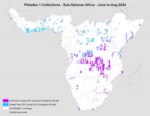 Este mapa muestra las áreas capturadas por la constelación Pléiades 1 desde el 1 de junio al 31 de agosto de 2024 sobre África Subsahariana. Ten en cuenta que en muchas instancias se recopilaron múltiples imágenes sobre la misma área, lo cual es difícil de representar en este mapa estático.
En esta publicación mensual, ofrecemos a nuestros lectores una visión general de la cobertura de imágenes de alta resolución recopiladas sobre una región específica durante un período determinado. Para ello, seleccionamos una constelación de satélites de alta resolución, un período de tiempo definido y un área de interés, y luego informamos estadísticas clave sobre la cantidad total de imágenes recopiladas en kilómetros cuadrados (km²). Sin más preámbulos, pasemos al análisis.
Región Gráfica de Interés: África Subsahariana más islas en alta mar
Superficie Terrestre Cubierta: 16,510,458.9 km²
Período de Tiempo: 1 de junio al 31 de agosto de 2024
Constelación de Satélites de Alta Resolución: Pléiades 1A/1B
Estadísticas de imágenes de la constelación Pléiades 1–África Subsahariana
Área total recopilada: 2,163,616.5 km²; 11,758.8 km² por satélite / por día
Área recopilada con menos del 20% de nubosidad y una inclinación de 30° o menos fuera del nadir: 955,850.6 km²; 5,194.8 km² por satélite / por día; 44.18% del total
Fernando Gutierrez
Topographic Translator
In this monthly feature, we span the globe to examine Our Changing Landscape with a time series of medium-resolution PlanetScope satellite imagery. The PlanetScope constellation dates back to 2016 and collects hundreds of millions of square kilometers of four and eight-band 3-meter imagery daily! In April, we checked out a historic January 2025 snowfall in Kansas City. For the May edition of this series, we are looking at the Maha Kumbh Mela in Prayagraj, India, which is considered to be the world’s largest human gathering.
The PlanetScope Microsat Constellation
 Click on the image above to see an animation of 3-meter natural color PlanetScope image collected over the Maha Kumbh Mela on December 22, 2024, as well as January 28 and 29, and February 3, 2025. In this animation, it is easy to spot just how much infrastructure must be built up before the Maha Kumbh Mela to handle the influx of millions of pilgrims–check out the two areas we circled in red. And it is also pretty amazing how quickly the tent-cities are created as in the December 22nd image, the area is nearly empty. We chose imagery from January 29th as it corresponded to Manui Amavasya, and then from February 3rd as it corresponded to Basant Panchami, both of which are key dates during this month-plus religious festival–the scale of which is almost overwhelming! (Images Courtesy: © Planet 2025)
PlanetScope is a constellation of more than 240 microsats referred to individually as Doves. Each Dove is able to collect up to 20,000 square kilometers (sq km) per day of 3-meter (m) 4-band multispectral (i.e. blue, green, red and near-infrared [NIR]) imagery; and newly launched SuperDoves collect 8-band multispectral adding in valuable red-edge spectral data. Across the constellation, PlanetScope is archiving more than 200 million sq km of medium-resolution imagery a day, making it the go to source for daily imagery over most locations. This massive archive dates back to 2016, offering the most complete and continuous record of spatial data on the planet since the start of the constellation’s ongoing launch schedule. Collecting 3-meter multispectral imagery is the equivalent of ‘high-resolution’ multispectral data imaged by a 75-centimer (cm) satellite (as this satellite would feature 75-cm panchromatic and 3-m multispectral), making PlanetScope an extremely competitively priced option at just $2.25 per sq km. With well registered images and nearly daily collections of most locations, PlanetScope is the ideal imagery source for this current-events focused series, Our Changing Landscape.
Maha Kumbh Mela in Prayagraj, India
The Maha Kumbh Mela is a Hindu pilgrimage festival that took place in Prayagraj, India, from January 13 through February 26, 2025. It is considered to be the world’s largest gathering of people and one of the most important festivals in the Hindu calendar.
Also known as the festival of the sacred pitcher, it is anchored in Hindu mythology. The congregation, primarily, includes Ascetics, Saints, Sadhus, Sadhvis, Kalpvasis and Pilgrims from all walks of life. Each site’s celebration is based on a distinct set of astrological positions of the Sun, the Moon and Jupiter. The celebrations occur at the exact moment when these positions are fully occupied, as it is considered to be the holiest time in Hinduism.
More than 660 million people took a dip in the river during the 2025 pilgrimage. The 2025 edition was unique since the constellation alignment seen is witnessed only once in 144 years, organizers said. In the images shared here, on January 29th, we can see Mauni Amavasya. Regarded as one of the most auspicious Hindu festivals, Mauni Amavasya is celebrated on the new moon (Amavasya) in the Magha month. The spiritually significant day is dedicated to the ancestors and bathing in the sacred rivers is thought to bestow virtue and salvation.
Then just a few days later on February 3rd, we see Basant Panchami in the imagery here. This festival starts the preparation for the arrival of spring. Basant Panchami is celebrated in Indian religions in different ways depending on the region. Basant Panchami also marks the start of preparation for Holika and Holi, which take place 40 days later.
If you would like to find out more about using 3-meter PlanetScope imagery for your academic studies, engineering projects or any landscape analysis, let us know at sales@apollomapping.com or (303) 993-3863.
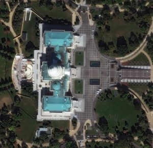
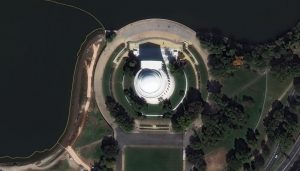 When visiting Washington, D.C. seeing the different memorials and the U.S. Capitol in person is simply an amazing experience. One particular memorial, the Thomas Jefferson Memorial, honors the man who was the first chief executive to be inaugurated at the Capitol; the third president of the United States; the politician who penned the Declaration of Independence, and the leader who sent the Lewis and Clark Expedition to the Pacific. Dedicated by President Franklin Delano Roosevelt on April 13, 1943, the Thomas Jefferson Memorial will celebrate its 82nd anniversary this year. The statue of Thomas Jefferson inside the domed structure is made of bronze and sits on a black Minnesota granite pedestal. It shows him holding the Declaration of Independence. The other image featured here shows a striking aerial view of the U.S. Capitol. It’s the meeting place of the U.S. Congress and on its grounds include buildings for the Senate and House of Representatives, the U.S. Botanic Garden, the Library of Congress, and a home for the Supreme Court. Construction of the Capitol starting in 1793, and since that time the U.S. Capitol has been built, burned, rebuilt, extended and restored. The building spans around 16.5 acres and has five levels, approximately 540 rooms, 658 windows (108 in the dome alone) and approximately 850 doorways. The 30-cm WorldView Legion images featured here was collected on October 19, 2024, and has custom processing and color balance applied by Apollo Mapping. (Satellite Imagery © 2025 Maxar Technologies)
In this monthly article, we travel the world to check out unique, fun and sometimes a bit weird 30-centimeter (cm) color imagery samples from the WorldView constellation. In March, we checked out images of Vina del Mar in Chile. For this edition of the 30-cm Color WorldView Image of the Month, we feature images of the Thomas Jefferson Memorial in Washington, D.C.
30-cm WorldView-3 (WV3) launched in late 2014, WorldView-4 (WV4) launched in late 2016 and then the first WorldView Legion satellites launched in 2024. Taken together, this is the most advanced satellite constellation the commercial marketplace has ever had access to. Here are a few of the features that really set these satellites apart from the competition:
- Improved Resolution
- Higher resolution means you can see more detail in WorldView imagery.
- Data collected at nadir will have 31-centimeter (cm) panchromatic, 1.24-meter (m) visible and near infrared, 3.7-m SWIR (WV3 only) and 30-m CAVIS (WV3 only) bands.
- Additional Spectral Bands
- If spectral analysis is part of your project, then no other satellite can match WorldView-3 and WorldView Legion with their 8 bands of visible and near-infrared data; and then 8 shortwave infrared bands (WV3 only) which are crucial for geological studies.
- Better Positional Accuracy
- With accuracies of 3.5-m CE90% or better (without ground control even!), the 30-cm WorldView constellation has no rivals for its enhanced positional accuracy.
- Daily Revisits
- With multiple WorldView-3 and WorldView Legion satellites orbiting our planet, daily revisits are available for most locations.
- WV4 is no longer collecting new imagery.
- Increased Collection Capacity
- WV3/4 feature 13.1-km swath widths (at nadir) with the ability to collect up to 680,000 square kilometers (sq km) of high-resolution data per day per satellite (though WV4 is dead now).
- When fully launched, WorldView Legion will feature six 30-cm satellites, significantly boosting the collection capacity of this leading high-resolution constellation.
If you are interested in WorldView-3, WorldView-4 and/or WorldView Legion imagery for your next project, please let us know by phone, 303-993-3863, or by email, sales@apollomapping.com.
You can also find more WV3 samples and technical information on our website here; WV4 samples and information can be found here; and then finally here is more information about WorldView Legion.