
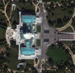
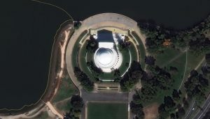
 When visiting Washington, D.C. seeing the different memorials and the U.S. Capitol in person is simply an amazing experience. One particular memorial, the Thomas Jefferson Memorial, honors the man who was the first chief executive to be inaugurated at the Capitol; the third president of the United States; the politician who penned the Declaration of Independence, and the leader who sent the Lewis and Clark Expedition to the Pacific. Dedicated by President Franklin Delano Roosevelt on April 13, 1943, the Thomas Jefferson Memorial will celebrate its 82nd anniversary this year. The statue of Thomas Jefferson inside the domed structure is made of bronze and sits on a black Minnesota granite pedestal. It shows him holding the Declaration of Independence. The other image featured here shows a striking aerial view of the U.S. Capitol. It’s the meeting place of the U.S. Congress and on its grounds include buildings for the Senate and House of Representatives, the U.S. Botanic Garden, the Library of Congress, and a home for the Supreme Court. Construction of the Capitol starting in 1793, and since that time the U.S. Capitol has been built, burned, rebuilt, extended and restored. The building spans around 16.5 acres and has five levels, approximately 540 rooms, 658 windows (108 in the dome alone) and approximately 850 doorways. The 30-cm WorldView Legion images featured here was collected on October 19, 2024, and has custom processing and color balance applied by Apollo Mapping. (Satellite Imagery © 2025 Maxar Technologies)
In this monthly article, we travel the world to check out unique, fun and sometimes a bit weird 30-centimeter (cm) color imagery samples from the WorldView constellation. In March, we checked out images of Vina del Mar in Chile. For this edition of the 30-cm Color WorldView Image of the Month, we feature images of the Thomas Jefferson Memorial in Washington, D.C.
30-cm WorldView-3 (WV3) launched in late 2014, WorldView-4 (WV4) launched in late 2016 and then the first WorldView Legion satellites launched in 2024. Taken together, this is the most advanced satellite constellation the commercial marketplace has ever had access to. Here are a few of the features that really set these satellites apart from the competition:
- Improved Resolution
- Higher resolution means you can see more detail in WorldView imagery.
- Data collected at nadir will have 31-centimeter (cm) panchromatic, 1.24-meter (m) visible and near infrared, 3.7-m SWIR (WV3 only) and 30-m CAVIS (WV3 only) bands.
- Additional Spectral Bands
- If spectral analysis is part of your project, then no other satellite can match WorldView-3 and WorldView Legion with their 8 bands of visible and near-infrared data; and then 8 shortwave infrared bands (WV3 only) which are crucial for geological studies.
- Better Positional Accuracy
- With accuracies of 3.5-m CE90% or better (without ground control even!), the 30-cm WorldView constellation has no rivals for its enhanced positional accuracy.
- Daily Revisits
- With multiple WorldView-3 and WorldView Legion satellites orbiting our planet, daily revisits are available for most locations.
- WV4 is no longer collecting new imagery.
- Increased Collection Capacity
- WV3/4 feature 13.1-km swath widths (at nadir) with the ability to collect up to 680,000 square kilometers (sq km) of high-resolution data per day per satellite (though WV4 is dead now).
- When fully launched, WorldView Legion will feature six 30-cm satellites, significantly boosting the collection capacity of this leading high-resolution constellation.
If you are interested in WorldView-3, WorldView-4 and/or WorldView Legion imagery for your next project, please let us know by phone, 303-993-3863, or by email, sales@apollomapping.com.
You can also find more WV3 samples and technical information on our website here; WV4 samples and information can be found here; and then finally here is more information about WorldView Legion.

Leave a Reply