
Have you noticed 50-centimeter (cm) 8-band SuperView Neo-3 in Image Hunter? If you have used the system recently, I bet you have seen tons of SuperView Neo-3 (SVN3) data given its massive footprint that is some 130-kilometers (km) wide, as well as an aggressive speculative tasking program by the vendor!
 A 50-cm color SuperView Neo-3 image collected over Washington, DC on December 12, 2024.
A part of the SuperView Neo constellation, Neo-3 differentiates itself from its satellite twins, Neo-1 01/02, with 2-meter (m) 8-band multispectral imagery as well as an industry-leading 130-km wide footprint. SuperView Neo-3 also images at 10° or less off-nadir so there is less tilt in the data, which is crucial in areas with tall buildings, trees, and mountains as well as those with deep, narrow passages. A massive 130-km wide footprint allows Neo-3 to collect an impressive 1.4 million sq km of 50-cm 8-band data daily.
Here are a few of the specifications that set SuperView Neo-3 apart from the competition:
- 50-cm panchromatic and 2-m 8-band multispectral, including blue, green, red and near infrared (NIR) plus coastal blue, yellow, red edge and NIR2.
- All images collected at 10° off-nadir or less.
- 130-km wide image footprint.
- 1.4-million sq km per day collection capacity.
So, if you are looking to uplevel your next spectral analysis, 50-cm 8-band SuperView Neo-3 is sure to be one of your go-to satellites.
You can query 50-cm SuperView Neo-3 on Image Hunter at any time! And if you have additional questions about using SuperView Neo-3 for your next mapping project, you can contact us now at sales@apollomapping.com.
In May, we looked at bustling downtown Los Angeles where the Fiesta Broadway is held. This month for the Pléiades 1–Pléiades Neo Point of Interest, we take a glimpse at the Telluride Blue Grass Festival, which will be held June 19-22, 2025, in Telluride, Colorado. Nestled in the rugged San Juan Mountains of Southwestern Colorado, the Telluride Bluegrass Festival offers a music festival set in a beautiful mountain backdrop.

 These two satellite images featured here show the festival grounds from above. The Pléiades Neo 4 30-cm color image from July 15, 2023 shows rows of houses and the large stage, still in its original place from when the festival was first established. But in the second photo, captured September 12, 2024 by Pléiades 1A, you can see tents for vendors and more scattered all around the property, where folks on the ground are setting up for the upcoming 2024 Telluride Blues and Brews Festival which started the next day. These images have custom processing and color balancing applied by Apollo Mapping. PLEIADES © CNES 2025, Distribution Airbus DS.
About the Point of Interest: Although the Telluride Bluegrass Festival focuses on bluegrass music, it typically features music from a variety of related genres. The first Telluride Bluegrass Festival was organized in 1974 by John Herndon, J.B. & Helen Matiotti, Kooster McAllister, and Fred Shellman, who played in the Fall Creek Boys. That year, the festival attracted approximately 1,000 music-lovers. The festival became an annual event with attendance once capped at 10,000. Since at least 2013, capacity has been set at 12,000 per day (48,000 total over the four days of the festival).
Fun Factoids: (1) One of the fun events at the festival is a band contest. Twelve bands are given slots in the competition. Judges rate the bands and the top four go to the main stage to compete before the crowd. (2) In 1990, the Dixie Chicks won the band contest. (3) NightGrass is the late-night magic of the festival. NightGrass concerts are held in venues around the town of Telluride, including the iconic Sheridan Opera House and Palm Theatre. (4) A cherished Festivarian tradition, FirstGrass is a free outdoor show in the Sunset Plaza in Mountain Village. Board the free gondola from Telluride up to Mountain Village, and plan to spend the evening dining at one of the numerous restaurants, wandering the shops, taking in the spectacular views, and enjoying the first official sounds of the Telluride Bluegrass Festival. (5) The 2025 lineup on the festival’s main stage includes Jason Isbell and the 400 Unit, Alison Krauss and Union Station, Jerry Douglas, Gillian Welch & David Rawlings, Sam Bush Band, Lake Street Dive, Zach Top, Greensky Bluegrass, Kasey Chambers and many more.
The 50-cm Pléiades 1 High-Resolution Satellite Constellation
The Pléiades 1 constellation (or at least part of it!) has been in orbit since December 2011 and if you have not had a chance to check out any sample imagery, take a few moments and have a look at the gallery on our website. If you work with high-resolution imagery, you should consider Pléiades 1 and Pléiades Neo for your next geospatial projects.
A variety of Pléiades 1 products are available from both a well-established archive and as a new collection, including 50-centimeter (cm) pansharpened imagery and 50-cm panchromatic–2-meter (m) 4-band multispectral bundles. We are happy to discuss the technical specifications, pricing and tasking options available with both of these satellite constellations.
The 30-cm Pléiades Neo High-Resolution Satellite Constellation
Pléiades Neo is our newest high-resolution satellite constellation. The first Neo satellite went up in April 2021 and the second in August of the same year. This 30-centimeter resolution constellation will add two more satellites in the next few months and upgrade from daily to intraday revisits. Pléiades Neo has six multispectral bands with 1.2-meter resolution, including a deep blue and two infrared bands, along with a 30-centimeter resolution panchromatic band.
The archive is growing every day, and the satellites are available for new collections, making Pléiades Neo the perfect solution for site monitoring. Check out our beautiful sample images in the Pléiades Neo gallery.
More sample images and technical information about Pléiades 1 can be found on our website here; while the same can be found here for the Pléiades Neo constellation.
The Apollo Mapping sales team can answer any questions you might have about Pléiades 1 and/or Pléiades Neo. We can be reached at (303) 993-3863 or sales@apollomapping.com.
During my junior year of high school, I was a member of the student senate, and we were deliberating about the need for more parking near campus. During the 90s, we were still in the era where kids found freedom through cars, and everybody who could get one, had one. The only problem was that there was not a lot of parking available near campus.
But one of the thoroughfares that abutted the school, Race Street, was wide and had ample room for two-way traffic and another lane of parking on the school-side of the street. The city council, however, was not willing to allow this, suggesting that adding parking there simply wouldn’t be safe.
This caused a bunch of us kids to go to the next city council meeting to create “good trouble” with a substantial presence while some of our more eloquent peers made their best pleas. The last one to speak, Chad, a sophomore, approached the desk where speakers were to sit as they gave their pitch, only he didn’t sit down.
Instead, he grabbed the microphone and said, “I’m not going to sit down because I’ve heard this chair is dangerous. There’s no evidence that it is, nobody has ever reported being injured from sitting in it, but there are still people who believe that they will be injured if they sit in it.” He paused and stared at the city council members, waiting for his cleverness to settle over them.
With a few final sputters of rebuttal, the council relented and conceded that nobody had ever been injured on that section of Race Street, and in fact, there hadn’t been any reported automobile accidents in the vicinity of the school because of the reduced speed limit and dense surrounding residential neighborhood. We students got our parking, and with it our perceived freedom. I can only assume Chad is a successful lawyer somewhere now.
 Be careful–it isn’t safe to sit there. (Image retrieved from here and comes courtesy of Plastic Lines.)
So, the other night I’m having dinner with a friend and his son, a 24-year-old college graduate, about to start a master’s program in education so he can become a high school teacher. God bless him.
We were talking about the state of higher education, and I was musing about some of the common narratives and recent attacks on academia by the Right, and specifically that of the supposed indoctrination campaigns that happen in classrooms across the country. To be clear, I’m sure this does happen in isolated instances with a handful of activist professors who have misinterpreted their core job duties. But these are instances of the proverbial ‘exception that proves the rule.’
I work at one of the most left-leaning public campuses in the Southeast, stocked full of liberal professors. Having been here for almost a decade, I know of no credible accusations of indoctrination from any student about any faculty member. Now, some faculty are certainly guilty of buying into the culture war issues du jour, but that is less a case of indoctrination than one of unbridled idealism.
I shifted from my concerns about the state of academia to the television series everyone has been raving about recently, Adolescence. In it, there are a few scenes that discuss the “manosphere” and Andrew Tate, specifically its/his effect on impressionable boys and young men, something my friend’s son agreed was a real problem in his own social circle.
And at that moment something clicked for me: if anyone is being indoctrinated, it’s those who have been sucked into the orbit of these noxious platforms and its “influencers”–for what is an influencer in today’s moral economy if not an indoctrinator?
Young men came out strong for Trump this last election, and that was in no small part due to the influence of the viper pit on the Far Right, including the alt-right, white nationalist, Christian nationalist, QAnon, xenophobes, misogynists, and conspiracy theory peddlers across the social media dungeons of cyberspace.
But as this very thought rattled through my head as I sat across from my young dinner guest, I realized that I was only perpetuating the cultural divide through my reductionist and dismissive categorization of those who get sucked into this orbit.
My classmate, Chad, would’ve said that we need to control the narrative without casting blame or engaging in the vilification of the people we seek to win over. He didn’t accuse any council member of ignorance; he didn’t even attack their ideas. He simply produced a simple and indisputable thought exercise that demonstrated why the dominant position was off base, inviting those whom he hoped to convince of his position to cross over in their own time. And they did.
To address this social problem, we need to recognize that we’re amidst an instance of “Moore’s paradox”: that it’s much easier to admit that you were wrong than that you are wrong. Any argument intended to win over people–and especially young men in the orbit of the manosphere–must provide an easy exit from past thinking deemed detrimental to society to future thinking that benefits democracy–and be available and accessible to each individual in their own time. This won’t lead to a sea change per se, but perhaps a slow shifting of the tides if we allow for this possibility.
It’s all about messaging. If you control the narrative, you control perception. But you can’t seize control of the narrative, you must earn it. If you won’t meet people where they are, then they won’t give you the opportunity to win them over.
This matters at the macrolevel (society), the meso-level (higher education), and at the microlevel (perhaps our field, but more specifically the students we engage with every day). But ultimately, this is about leisure–the manosphere is an attempt at the intentional reordering of the spaces of leisure for a generation of boys and young men. This inverts Chad’s thought experiment–in this instance, we know the seat is dangerous. How do we encourage them to find somewhere safer to sit?
Marco Esquandoles
Messenger
If you are searching for medium and high-resolution satellite imagery, the search is over as Image Hunter is the solution you’ve been looking for! Featuring satellite and aerial imagery as well as digital elevation models (DEMs) from a constantly expanding list of 60+ constellations/datasets and 19 vendors, our database contains more than 200-million images/records meaning there is just no other website out there with this breadth of commercial data products. Our interface is slim-lined and modern, loading quickly on all platforms, browsers and operating systems. Further, our database is updated multiple times an hour with the most recent images collected by WorldView-3, Pléiades 1, PlanetScope, SuperView-1 and many more so you are sure to get the most current view of all the imagery and DEM databases we work with. Once you submit your request, an Apollo Mapping representative will be in touch within 4 Colorado business hours to get you the pricing information you need for your project.
So why wait? Give Image Hunter a try now to find the imagery and/or DEM data you need for your next mapping project!
Key Improvement(s) From The Past Month
It’s been another month of bug fixes and monitoring system stability. In fact, our system has never been more secure than now, and we hope all of our users have noticed the improvements in Image Hunter’s speed and stability as well! We are also getting close to deploying a fix for some missing satellite previews as well as a new 50-centimeter 4-band satellite constellation–stay tuned there.
Here is a summary of the changes/improvements we made to Image Hunter during the past month:
- Significantly improved the handling and stability of data updates.
- If you pressed the Delete button while entering a date in the filters, it white screened–but not anymore.
- The next two 30-cm 8-band WorldView Legion satellites are ready for instant access as soon as they are added to the Maxar API.
- Some metadata for WorldView Legion was not updating daily, now it does.

Data Alert–An Automated Daily Imagery Search
Have you checked out Data Alert which lets you define an area of interest anywhere around the globe, the resolution your project requires and the number of months we should keep the alert active? Once an alert is set up, we check for new data over your area of interest every single day, and send you an email when we find coverage that meets your specifications. We have a short YouTube video with directions to set up a Data Alert, check out the last video; and we have written directions for Data Alert here.
The Sensors Available in Image Hunter
As you might have seen in past articles, we now feature hourly updates (seriously!) of GeoEye-1, KOMPSAT 3/3A, Pléiades 1 and Neo, SPOT 6/7, SuperView-1/2/Neo, WorldView-1/2/3/Legion!
Image Hunter can be accessed 24 hours a day, 7 days a week and is a one-stop shop for every major source of medium and high-resolution satellite (and aerial!) imagery on the market today, including:
- WorldView Legion
- WorldView-4
- WorldView-3
- WorldView-2
- WorldView-1
- QuickBird
- GeoEye-1
- IKONOS
- EROS B
- KOMPSAT-3A
- KOMPSAT-3
- KOMPSAT-2
- Pléiades 1 constellation
- Pléiades Neo constellation
- TerraSAR-X (TerraSAR-X, TanDEM-X and PAZ)
- GEOSAT-1
- GEOSAT-2
- TripleSat
- BJ3A
- BJ3N
- SPOT 1 to 7 constellation
- RapidEye
- GaoFen-2
- GaoFen-1
- ZiYuan-3 01/02 (mono and stereo!)
- FORMOSAT-5
- FORMOSAT-2
- ALOS PRISM (stereo)
- AW3D Standard (DEM)
- SkySat constellation
- PlanetScope constellation (including 5-band SuperDove data)
- SuperView-1 constellation
- SuperView-2
- SuperView Neo-1 01/02
- SuperView Neo-3
- Landsat 1-8
- TeLEOS-1
- Hexagon (HxGN Content Program aerial imagery) imagery + DEM
- WorldDEM
- WorldDEM Neo
- Vricon DEMs
- Orbita Hyperspectral Satellite (OHS)
- KazEOSat-1
- KazEOSat-2
- Jilin-1 Optical
- Jilin-1 Video (including nighttime imagery)
- Jilin-1 GF/DP
- Jillin-1 KF
- Orbita Video Satellites-1/2/3 (OVS-1/2/3)
- BlackSky Global series
Key Features of Image Hunter
If any of our readers have struggled with other geospatial search engines that are clunky, only query one data source and/or do not provide image previews, then Image Hunter is the solution to your woes as it features:
- Online browsing of satellite and aerial imagery from 19 data providers and 56 satellite and aerial imagery derived datasets.
- Near-instantaneous loading of low-resolution preview imagery with collection date, cloud cover and other key metadata.
- The ability to define your area of interest by address, coordinates, geometric shape or shapefile/KMZ.
- A responsive basemap with street names to provide spatial context when discovering data as well as crowd-sourced updates for the most accurate map possible.
- Exports of the area of interest you create as well as the scenes you select in shapefile or KMZ format.
- Support for all operating systems, and not just our friends with Windows machines!
Image Hunter can be accessed here all day and night, we are excited to find out what you think about our imagery search engine! So if you have any ideas and/or feedback to improve Image Hunter, please let us know at sales@apollomapping.com or (303) 993-3863.
¡Bienvenidos a junio! Nosotros en Apollo Mapping estamos gustosos de tenerlos otro mes aquí en los resúmenes españoles del mes de junio.
PRODUCTO DESTACADO–SuperView Neo-3 de 50 cm y 8 bandas–¡Con una huella masiva!
¿Has notado el SuperView Neo-3 de 50 centímetros (cm) y 8 bandas en Cazador de Imágenes?
Si has usado el sistema recientemente, apuesto a que has visto toneladas de datos del SuperView Neo-3 (SVN3) debido a su huella masiva de aproximadamente 130 kilómetros (km) de ancho, además de un agresivo programa especulativo de adquisición por parte del proveedor.
Imagen color de 50 cm del SuperView Neo-3 capturada sobre Washington, DC el 12 de diciembre de 2024.Como parte de la constelación SuperView Neo, Neo-3 se diferencia de sus satélites gemelos, Neo-101/02, con imágenes multiespectrales de 8 bandas y 2 metros de resolución, así como una huella líder en la industria de 130 km de ancho. SuperView Neo-3 también captura imágenes con un ángulo de desviación nadiral de 10° o menos, lo cual es crucial en zonas con edificios altos, árboles, montañas o pasajes estrechos y profundos, ya que minimiza la distorsión por inclinación. Una huella masiva de 130 km permite que el Neo-3 recoja un impresionante total diario de 1.4 millones de km² de datos multiespectrales de 8 bandas a 50 cm.
Algunas especificaciones que destacan al SuperView Neo-3 frente a la competencia:
- Imágenes pancromáticas de 50 cm y multiespectrales de 8 bandas a 2 metros, que incluyen: azul, verde, rojo e infrarrojo cercano (NIR), más azul costero, amarillo, borde rojo y un segundo infrarrojo cercano (NIR2)
- Todas las imágenes se capturan a 10° de desviación nadiral o menos
- Huella de imagen de 130 km de ancho
- Capacidad de recolección diaria de 1.4 millones de km²
Así que, si estás buscando llevar tu próximo análisis espectral al siguiente nivel, el SuperView Neo-3 de 50 cm y 8 bandas será sin duda uno de tus satélites de referencia.
Puedes consultar los datos del SuperView Neo-3 de 50 cm en Cazador de Imágenes en cualquier momento.
Y si tienes preguntas adicionales sobre cómo usar SuperView Neo-3 en tu próximo proyecto cartográfico, puedes contactarnos ahora a sales@apollomapping.com.
Descanso De Trabajo Con Imágenes–Exhibición Internacional Marítima y Aeroespacial de Langkawi
Nos encantan los mapas.
Nos encantan las imágenes satelitales.
Y también nos encantan los descansos en medio del trabajo.
¡Esperamos que a ti también!

A quienes disfrutan de todo lo que vuela y flota, les encantará saber más sobre la Exhibición Internacional Marítima y Aeroespacial de Langkawi. Este evento se lleva a cabo cada dos años —en los años impares— en Langkawi, Malasia. Este año se celebrará la 17.ª edición del evento, del 20 al 24 de mayo. Para darte una idea de cómo se ve la exhibición desde las alturas, presentamos una imagen capturada por Pléiades Neo 3 a 30 centímetros de resolución el 27 de mayo de 2023.
Conocida como LIMA, esta exhibición es una de las más grandes de su tipo en la región Asia-Pacífico. Las exhibiciones aeroespaciales se instalan en el Centro Internacional de Exposiciones Mahsuri, junto al Aeropuerto Internacional de Langkawi, mientras que las exhibiciones marítimas se llevan a cabo en Resorts World Langkawi.
LIMA es la única exhibición en el mundo que combina sectores marítimo y aeroespacial, y funciona como plataforma para usos defensivos, comerciales e industriales. En ediciones anteriores, el evento ha recibido alrededor de 230,000 visitantes y más de 500 expositores.
No olvides ver nuestra imagen en color de 30 cm… quizás te inspire a reservar un vuelo a Malasia para asistir al gran evento del próximo mes.
Que sigas teniendo un excelente día de trabajo.
(Crédito de imagen: Airbus. Procesado por Apollo Mapping para mejorar precisión de color y claridad.)
Colecciones de Imágenes de Alta Resolución–WorldView-2/3–África Subsahariana, junio a agosto de 2024
En esta serie mensual ofrecemos una visión general de la cobertura de imágenes satelitales de alta resolución recolectadas sobre una región durante un período específico. Para hacerlo, seleccionamos una constelación satelital, un intervalo de tiempo y un área de interés definidos, y luego reportamos estadísticas clave sobre la cantidad total de imágenes recolectadas en kilómetros cuadrados. Sin más preámbulos, vamos a nuestro análisis.
 Este mapa muestra las áreas captadas por la constelación WorldView-2/3 entre el 1 de junio y el 31 de agosto de 2024 sobre África Subsahariana. En muchos casos se recolectaron múltiples imágenes de la misma zona, lo cual no se representa fácilmente en este mapa estático.
Región Gráfica de Interés: África Subsahariana e islas cercanas
Superficie Terrestre Cubierta: 16,510,458.9 km²
Período de Tiempo: el 1 de junio al 31 de agosto de 2024
Constelación de Satélites de Alta Resolución: WorldView-2/3
Estadísticas de Imágenes de la Constelación Pléiades 1–África Subsahariana
Área Total Recolectada: 8,356,120.0 km²; 45,413.7 km² por satélite/día
Área recolectada con 20% o menos de nubes y 30 grados o menos de inclinación: 3,712,693.1 km²; 20,177.7 km² por satélite/día; 44.43 % del total.
Fernando Gutierrez
Topographic Translator
- Every month we feature some of the craziest and neatest technological advancements from around the world, so without further delay, let’s jump into the June list!
A way to make LED lighting even more efficient.
Solar cells made of Moon dust!
A unique way to reduce motion sickness.
Low-cost method to produce clean water and hydrogen gas from seawater.
A soft, liquid battery.
Do chimps go to bars too?
This metamaterial is both strong and stretchable.
Engineered stomach microbe absorbs less mercury from seafood.
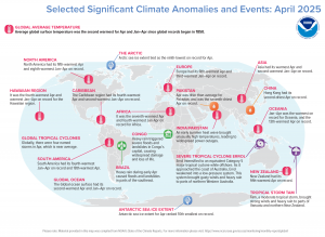 During April 2025, North America experienced its fifth warmest April and eighth warmest January-April on record. The Caribbean region had its fourth warmest April and second warmest January through April on record. Heavy rain triggered severe floods and landslides in Congo’s capital, causing widespread damage and loss of life. Heavy rain during early April in Brazil caused floods and landslides in parts of the southeast. Hong Kong had its second driest April on record and Asian had its warmest April and second warmest January through April on record. (Image Credit: NOAA Global Climate Report)
- The NOAA Global Climate Change Report for April 2025 has been released by the National Centers for Environmental Information and reveals further proof that global climate change remains a concern. April 2025 temperature was 1.22°C (2.20°F) higher than the 20th Century average. This was the second warmest April in NOAA’s 176-year record and was only 0.07°C (0.13°F) cooler than the record-warm April 2024. Notably, the 10 warmest Aprils on record have all occurred since 2010, with nine of them occurring since 2016. April 2025 also marked the 49th consecutive April with above-average global temperatures. The global land-only April temperature was 1.97°C (3.55°F) higher than the 20th Century average, surpassing the previous record set back in April 2016 by 0.05°C (0.09°F). The global ocean-only temperature was second highest on record for April at 0.88°C (1.58°F) higher than the 20th Century average. This value was 0.13°C (0.23°F) cooler than the record-high April 2024.
- June is National Dairy Month, celebrated across the country by the dairy industry, farmers, and producers of dairy products. Unofficially, June 4 happens to be National Cheese Day. Cheese is produced from the pressed curds of milk. According to Kitchen Aid, there are more than 2,000 types of cheese. The six most common cheese categories are hard, soft, blue, pasta filata, soft-ripened and processed. But before cheese processors can even think about making cheese, they need to procure the milk from dairy cattle. There are numerous dairy milk haulers who rely on GIS and logistics tools to help map out the collection points of milk from dairies that don’t process their own line of products on the farm. Land O’Lakes agricultural cooperative, which was founded nearly 100 years ago by 320 creameries to improve the quality, consistency, marketing and economics of its dairy products, is one of the largest co-ops in the United States. It includes about 4,000 members and more than 10,000 employees. Its industries include dairy products, animal feed, and crop inputs and insights with sales totaling $13–$15 billion per year. In 2013, Land O’Lakes started using GIS to show co-op members mapping information related to trade areas for projects, as well as where their facilities are located within the trade area and where their competitors are located, explained Josie Taylor with Land O’Lakes. “This allows us to visually tell them a story about the geographic dynamics of the trade area we are analyzing and how we are thinking about improving it,” Taylor said. The second way the team uses GIS is for field data collection. “We often need to go out and look at the facilities that the co-ops are running and analyze how they are operating them. What are the capabilities of those facilities? How old are they? Can we expand those facilities?” Taylor said. “We use [Survey123 for ArcGIS] to capture a comprehensive and consistent set of data about the facilities.” The third way in which Land O’Lakes uses GIS is for analytics. “If we’ve got multiple facilities that are close together, we analyze where the trade areas overlap. We also perform transportation analysis to determine how products are currently being delivered to our customers and if there is a more efficient way to do it. That’s often about reallocating customers to a specific facility–that is, analyzing the facility they are currently using compared to one that is more appropriate for their use based on distance, functionality, future growth, and so on,” Taylor said. Taylor and her team also use GIS to explore drive-time routes within specific trade territories, as well as route planning. The SAM team uses GIS extensively to conduct market and logistics analyses when deciding if cooperatives should make large-scale capital investments or not. “In our consulting practice, we are seeing increased demand for projects that provide long-term solutions in the changing agricultural industry, and GIS is critical in performing the necessary analyses,” Taylor said.
Brock Adam McCarty
Map Wizard
(720) 470-7988
brock@apollomapping.com
We love maps.
We love imagery.
We love work breaks.
We hope you like them as well!
Fans of things that fly and float will love learning more about the Langkawi International Maritime and Aerospace Exhibition. The event is held every two years–on odd-numbered years–in Langkawi, Malaysia. This year will be the year for another exhibition to take place, with the 17th Langkawi International Maritime and Aerospace Exhibition running from May 20th to 24th. To give you an idea of what the exhibition looks like, we peer down from above in our featured image, which was captured by 30-centimeter Pléiades Neo 3 on May 27, 2023.
Known as LIMA, the exhibition happens to be one of the largest of its kind in the Asia-Pacific region. The aerospace exhibitions are set up inside the Mahsuri International Exhibition Centre next to the Langkawi International Airport, while the maritime exhibitions are held at Resorts World Langkawi.
The only exhibition of its kind in the world, the Langkawi International Maritime and Aerospace Exhibition, or LIMA for short, is a platform for defense, commercial, and industrial uses. So far, the event has seen an estimated 230,000 public and trade visitors with more than 500 exhibitors on hand.
Be sure and check out our 30-cm color image and see if it inspires you to book a flight to Malaysia for next month’s big event.
Have a great rest of your workday! 😊
(Image Courtesy: Airbus. Processed by Apollo Mapping for improved color accuracy and clarity.)
In this monthly feature, we span the globe to examine Our Changing Landscape with a time series of medium-resolution PlanetScope satellite imagery. The PlanetScope constellation dates back to 2016 and collects hundreds of millions of square kilometers of four and eight-band 3-meter imagery daily! In May, we checked out Maha Kumbh Mela in Prayagraj, India, which is considered to be the world’s largest human gathering. For the June edition of this series, we are looking at the 2024 edition of the Bonnaroo Festival, which ran June 13th to the 16th with artists performing on more than 10 stages.

Click on the image above to see an animation of 3-meter natural color PlanetScope image collected over the area where Bonnaroo is put on yearly on May 28, June 10 and June 15, 2024. In this animation, you can see the initial state of the Bonnaroo festival area as well as the campgrounds in the May 28th image. By June 10th, just a few days before the festival starts, you can see a build-up of the infrastructure that supports the event. And then in the June 15th image you can see a packed house both by the stages and in the campgrounds, wow! (Images Courtesy: © Planet 2025)
The PlanetScope Microsat Constellation
PlanetScope is a constellation of more than 240 microsats referred to individually as Doves. Each Dove is able to collect up to 20,000 square kilometers (sq km) per day of 3-meter (m) 4-band multispectral (i.e. blue, green, red and near-infrared [NIR]) imagery; and newly launched SuperDoves collect 8-band multispectral adding in valuable red-edge spectral data. Across the constellation, PlanetScope is archiving more than 200 million sq km of medium-resolution imagery a day, making it the go to source for daily imagery over most locations. This massive archive dates back to 2016, offering the most complete and continuous record of spatial data on the planet since the start of the constellation’s ongoing launch schedule. Collecting 3-meter multispectral imagery is the equivalent of ‘high-resolution’ multispectral data imaged by a 75-centimer (cm) satellite (as this satellite would feature 75-cm panchromatic and 3-m multispectral), making PlanetScope an extremely competitively priced option at just $2.25 per sq km. With well registered images and nearly daily collections of most locations, PlanetScope is the ideal imagery source for this current-events focused series, Our Changing Landscape.
2024 Bonnaroo Festival
The 2024 Bonnaroo Festival spanned four days on a site southwest of Nashville, Tennessee. The bands performed from sunrise to long past sunset with the 2024 artists on the docket including Megan Tee Stallion, Post Malone, Pretty Lights, Eggy and Geese, The Heavy Heavy, Interpol, Thundercat, Red Hot Chili Peppers, and Cage the Elephant.
Around 70,000 people attended the 2024 festival, with an array of musical styles represented, including indie rock, classic rock, world music, hip hop, jazz, Americana, bluegrass, country music, folk, gospel, reggae, pop, electronic, and other alternative music.
R&B singer D’Angelo marked his return to American stages for the first time in over 12 years, with a surprise performance at the festival’s annual Superjam. He was backed by members of the R&B collective the Soulquarians, most notably Questlove, James Poyser and Pino Palladino, with guest guitarist Jesse Johnson. The set was composed almost entirely of covers. In 2009, the Beastie Boys played their final ever show at Bonnaroo.
Other past Bonnaroo performers have included Widespread Panic (2002, 2003, 2005, 2007, 2008, 2011), Phish (2009, 2012, 2019), The Dead (2003, 2004), Dead & Company (2016), U2 (2017), Pearl Jam (2008, 2016), Billy Joel (2015), Mumford & Sons (2011, 2015), Elton John (2014), Eminem (2011, 2018), Jack White (2010, 2014), Lionel Richie (2014), the Flaming Lips (2003, 2007, 2010, 2014), Paul McCartney (2013), Tom Petty and the Heartbreakers (2006, 2013), Wu-Tang Clan (2013), Red Hot Chili Peppers (2012, 2017, 2024), Radiohead (2006, 2012), Neil Young (2003, 2011), Dave Matthews Band (2005, 2010), Stevie Wonder (2010), Bruce Springsteen and the E Street Band (2009), Nine Inch Nails (2009), Metallica (2008), the Police (2007), Tool (2007, 2022), and Bob Dylan (2004).
Bonnaroo also offers a variety of activities throughout the weekend including parades, dance shows, yoga, sustainability lessons, a 5K run, a marriage barn, a water slide, vendor markets, and more.
The 2025 event will run June 12th to the 15th at the same site.
If you would like to find out more about using 3-meter PlanetScope imagery for your academic studies, engineering projects or any landscape analysis, let us know at sales@apollomapping.com or (303) 993-3863.