
¡Bienvenidos a agosto! Nosotros en Apollo Mapping estamos gustosos de tenerlos otro mes aquí en los resúmenes españoles del mes de agosto.
Tu descanso de trabajo con imágenes–Final de la Copa Mundial Femenina 2023
Nos encantan los mapas.
Nos encantan las imágenes satelitales.
Nos encantan los descansos en medio del trabajo.
¡Esperamos que a ti también!
En la final de la Copa Mundial Femenina 2023, los fanáticos del fútbol vieron a España derrotar a Inglaterra 1-0 en el Stadium Australia en Sídney, ganando su primer título mundial femenino. Olga Carmona anotó el gol de la victoria para España. El partido fue el evento deportivo femenino más visto en la televisión en 2023 con 38.4 millones de horas de visualización. Cerca de 76,000 personas llenaron el estadio para ver en persona el emocionante encuentro. Para ambos equipos, fue su primera aparición en una final de la Copa Mundial Femenina. También fue la tercera final completamente europea en la historia del torneo desde 1995.
Stadium Australia fue construido para los Juegos Olímpicos de Verano del 2000 y abrió sus puertas en marzo de 1999. Además de albergar las ceremonias de apertura y clausura olímpicas y las competencias de atletismo, el estadio fue sede del partido por la medalla de oro en fútbol masculino. También fue una de las sedes de la Copa Asiática AFC masculina 2015, donde se jugaron siete partidos, incluida la final. En ese encuentro, Australia venció a Corea del Sur para ganar el torneo por primera vez. El Stadium Australia también fue escenario de la victoria en penales de Australia sobre Uruguay en 2005 en el repechaje OFC–CONMEBOL, que clasificó a los Socceroos al Mundial 2006, su primera participación desde 1974.
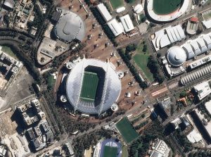
La imagen de 50 cm del satélite Pléiades 1B que compartimos aquí fue tomada el 20 de agosto de 2023, sobre el Accor Stadium en Sídney, Australia, donde se jugaría más tarde ese mismo día la final de la Copa Mundial Femenina. Podemos ver el estadio envuelto en un brillante exterior plateado y con un techo retráctil.
No dejes de ver nuestra imagen del descanso de trabajo e imagina un partido de fútbol desarrollándose dentro de ese estadio de diseño impresionante. Marca en tu calendario la Copa Mundial Femenina 2027 en Brasil y no te la pierdas en la televisión, ¡seguro que serán partidos increíbles!
Que sigas teniendo un excelente día de trabajo.
(Crédito de la imagen: Airbus. Procesada por Apollo Mapping para mejorar la precisión y claridad en escala de grises.)
PRODUCTO DESTACADO–Datos de WorldView de 8 bandas + PlanetScope
 ¿Te imaginas trabajar con esta colorida imagen de 50 cm de WorldView-2 con 8 bandas? Eso es el doble de información espectral por el mismo bajo costo. Esta imagen de 50 cm de Maxar WorldView-2 fue capturada sobre Central City, Pennsylvania, el 1 de octubre de 2012.
¿Sabías que, gracias a los cambios recientes en los precios de las imágenes satelitales de alta resolución de 8 bandas de WorldView-2, WorldView-3 y WorldView Legion, puedes ordenar esta información espectral adicional por el mismo precio que los datos de 4 bandas? ¡Así es, lo escuchaste bien! Entonces, ¿por qué no mejorar tu análisis espectral sin costo adicional?
Y además, puede que no sepas que la mayoría de las imágenes PlanetScope de 3 metros pueden entregarse con 4 bandas o 8 bandas ¡por el mismo precio también!
Así que, cuando llegue el momento de empezar un proyecto que incluya detección de cambios, clasificación de uso/cobertura del suelo, análisis de vegetación u otro tipo de análisis espectral, ¿por qué no usar imágenes de 8 bandas de WorldView o PlanetScope por el mismo costo?
Mándanos un correo en cualquier momento para mejorar tu análisis espectral sin costo adicional utilizando imágenes satelitales de 8 bandas en tu próximo proyecto geoespacial.
Colecciones de Imágenes de Alta Resolución–WorldView-2/3–Europa (Excepto Rusia), febrero a mayo de 2025
 Este mapa muestra las áreas captadas por la constelación WorldView-2/3 entre el 19 de febrero y el 19 de mayo de 2025 sobre Europa y sus islas, excepto Rusia. Ten en cuenta que en muchos casos se recolectaron múltiples imágenes sobre la misma zona, lo cual es difícil de representar en este mapa estático.
En esta publicación mensual, ofrecemos a nuestros lectores una idea de la cobertura de imágenes satelitales de alta resolución recolectadas sobre una región durante un período de tiempo específico. Para ello, seleccionamos una constelación de satélites de alta resolución, un marco temporal definido y un área de interés, y luego informamos estadísticas clave sobre la cantidad total de imágenes recolectadas en kilómetros cuadrados (km²). Sin más demora, pasemos a nuestro análisis.
Región Gráfica de Interés: Europa y sus islas asociadas, excepto Rusia
Superficie Terrestre Cubierta: 5,966,899.4 km²
Período de Tiempo: del 19 de febrero al 19 de mayo de 2025
Constelación de Satélites de Alta Resolución: WorldView-2/3
Estadísticas de imágenes de la constelación WorldView-2/3–Europa excepto Rusia
Área Total Recolectada: 5,252,776.9 km²; 29,182.1 km² por satélite por día
Área recolectada con 20% o menos de nubes y 30 grados o menos de inclinación: 1,665,242.8 km²; 9,251.3 km² por satélite por día; 31.70% del total
Fernando Gutierrez
Topographic Translator
We love maps.
We love imagery.
We love work breaks.
We hope you like them as well!
In the 2023 Women’s World Cup final, soccer fans watched Spain defeat England 1-0 at Stadium Australia in Sydney, winning their first ever Women’s World Cup title. Olga Carmona scored the winning goal for Spain. The match was the most watched women’s sporting event on TV in 2023 with 38.4 million viewing hours. Nearly 76,000 people filled the stadium to watch the exhilarating match in person. For both teams, this was the first appearance in a Women’s World Cup final. It also was the third all-European final in Women’s World Cup history since 1995.
Stadium Australia was built for the 2000 Summer Olympics and opened in March 1999. In addition to the opening and closing Olympic ceremonies and the track and field events, the stadium hosted the men’s football gold medal match. The venue was also chosen as a site for the men’s 2015 AFC Asian Cup, where it hosted seven matches including the final. In the final match, Australia beat South Korea to win the tournament for the first time. Stadium Australia also hosted a 2005 shootout victory over Uruguay in the OFC–CONMEBOL playoff, which qualified the Socceroos for the 2006 World Cup, their first appearance since 1974.
The 50-cm Pleiades 1B image we share here is from August 20, 2023, collected over Accor Stadium in Sydney, Australia where the Women’s World Cup final match would be held later that day. We can see the stadium encased inside a gleaming silver exterior and a retractable roof.
Be sure and check out our Work Break image and imagine a soccer game unfolding inside that impressively designed stadium. Mark your calendar for the 2027 Women’s World Cup in Brazil and tune in on TV to watch what’s bound to be some incredible matches.
Have a great rest of your workday! 😊
(Image Courtesy: Airbus. Processed by Apollo Mapping for improved grey-scale accuracy and clarity.)
This map shows the areas imaged by the WorldView-2/3 constellation from February 19 to May 19, 2025 over Europe and its islands, minus Russia. Please note that in many instances, multiple images were collected over the same area which is difficult to portray on this static map.In this monthly piece, we give our readers a sense of the high-resolution imagery coverage collected over a geography during a specified window. To do this, we pick a high-resolution satellite constellation, a defined time period and area of interest, then report key statistics on the total amount of imagery collected in square kilometers (sq km). Without further delay, let’s jump into our analysis.
Graphic Region of Interest: Europe and associated islands minus Russia
Land Mass Covered: 5,966,899.4 sq km
Time Period: February 19 to May 19, 2025
High-Resolution Satellite Constellation: WorldView-2/3
WorldView-2/3 Constellation Imaging Statistics–Europe Minus Russia
Total Area Collected: 5,252,776.9 sq km; 29,182.1 sq km per satellite/per day
Area Collected @ 20% or Less Clouds & 30 Degrees or Less Off-Nadir: 1,665,242.8 sq km; 9,251.3 sq km per satellite/per day; 31.70% of total
In this monthly feature, we span the globe to examine Our Changing Landscape with a time series of medium-resolution PlanetScope satellite imagery. The PlanetScope constellation dates back to 2016 and collects hundreds of millions of square kilometers of four and eight-band 3-meter imagery daily! In July, we looked at the destruction caused by a 7.7 magnitude earthquake in Myanmar that struck the region on March 28th. For the August edition of this series, we are heading to Saudi Arabia to look at the NEOM Campus and surrounding area as it changed it from 2016 to present time.
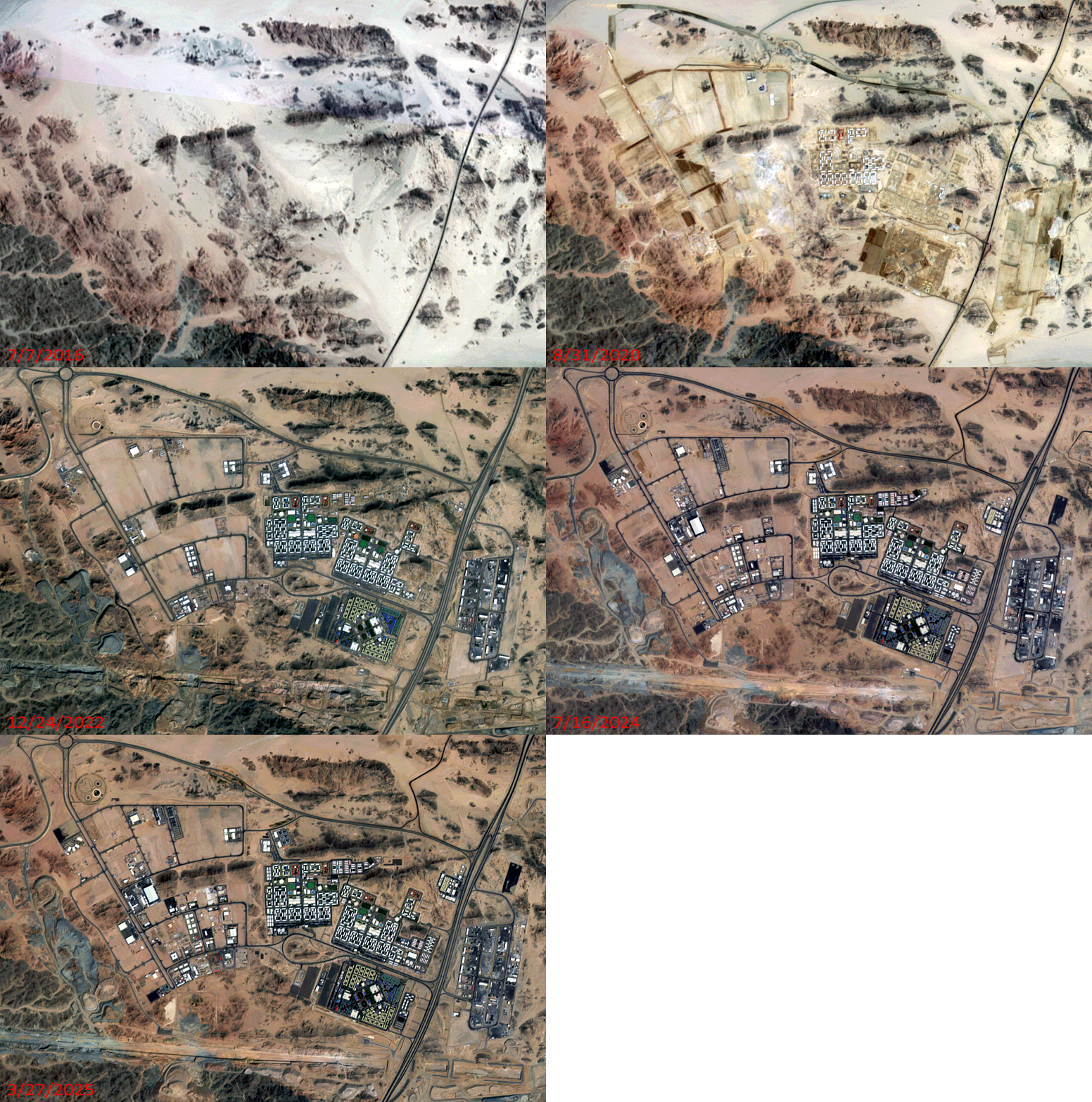 Click on the image above to see an animation of 3-meter natural color PlanetScope image collected over the NEOM Campus area in Saudi Arabia on July 7, 2016, August 31, 2020, December 24, 2022, July 16, 2024, and then March 27, 2025. In this animation, you can see how quickly the NEOM campus has grown in the past three years as compared to the period from 2016 to 2022. If you look at the southern part of the animation, you can also see progress on the construction of NEOM’s linear city which is a massively long, linear structure. Also, you can see just how remote this area was before the construction of NEOM started, which is very sad indeed. (Images Courtesy: © Planet 2025)
The PlanetScope Microsat Constellation
PlanetScope is a constellation of more than 240 microsats referred to individually as Doves. Each Dove is able to collect up to 20,000 square kilometers (sq km) per day of 3-meter (m) 4-band multispectral (i.e. blue, green, red and near-infrared [NIR]) imagery; and newly launched SuperDoves collect 8-band multispectral adding in valuable red-edge spectral data. Across the constellation, PlanetScope is archiving more than 200 million sq km of medium-resolution imagery a day, making it the go to source for daily imagery over most locations. This massive archive dates back to 2016, offering the most complete and continuous record of spatial data on the planet since the start of the constellation’s ongoing launch schedule. Collecting 3-meter multispectral imagery is the equivalent of ‘high-resolution’ multispectral data imaged by a 75-centimer (cm) satellite (as this satellite would feature 75-cm panchromatic and 3-m multispectral), making PlanetScope an extremely competitively priced option at just $2.25 per sq km. With well registered images and nearly daily collections of most locations, PlanetScope is the ideal imagery source for this current-events focused series, Our Changing Landscape.
Big Changes On The NEOM Campus And Surrounding Area
NEOM is a futuristic city-state under construction in northwest Saudi Arabia, encompassing a vast area with multiple regions and planned developments. It’s a key component of Saudi Arabia’s Vision 2030, which aims to diversify the economy and create a sustainable future. NEOM includes a variety of sectors, including a gaming campus, education, and a hub for media and production.
Launched in 2017 by crown prince Mohammad bin Salman, the site is at the northern tip of the Red Sea, due east of Egypt across the Gulf of Aqaba and south of Jordan. Multiple regions are planned, including a floating industrial complex, a global trade hub, tourist resorts, and a linear city powered by renewable energy sources.
Supporters hope the city will be completed by 2030, with the upcoming Saudi VISION 2030 around the corner, but some aren’t sure it will be done by then. In 2024, the Sindalah project was completed, three years after schedule and at three times its initial cost. The project’s estimated costs exceed $8.8 trillion (more than 25 times the annual Saudi budget), organizers say.
If you would like to find out more about using 3-meter PlanetScope imagery for your academic studies, engineering projects or any landscape analysis, let us know at sales@apollomapping.com or (303) 993-3863.
Imagine working with this colorful 50-cm WorldView-2 image with 8 bands? That is twice the spectral information for the same low cost. This 50-cm Maxar WorldView-2 image was collected over Central City, Pennsylvania on October 1, 2012.Did you know that given recent pricing changes for high-resolution 8-band WorldView-2, WorldView-3 and WorldView Legion satellite imagery, you can order this additional spectral information for the same price as 4-band data?! Yep, you heard that right, so why wouldn’t you uplevel your spectral analysis for no additional cost?!
And additionally, you might not know that most 3-meter PlanetScope images can be delivered with either 4-bands or 8-bands for the same cost as well!
So, when it comes time to get started on a project that includes change detection, land use-land cover classification, vegetation analysis, and/or any other spectral analysis, why not use 8-band WorldView or PlanetScope data for the same cost?!
Send us an email at any time to uplevel your spectral analysis for no additional cost by using 8-band satellite imagery for your geospatial next project.
If you are searching for medium and high-resolution satellite imagery, the search is over as Image Hunter is the solution you’ve been looking for! Featuring satellite and aerial imagery as well as digital elevation models (DEMs) from a constantly expanding list of 60+ constellations/datasets and 19 vendors, our database contains more than 200-million images/records meaning there is just no other website out there with this breadth of commercial data products. Our interface is slim-lined and modern, loading quickly on all platforms, browsers and operating systems. Further, our database is updated multiple times an hour with the most recent images collected by WorldView-3, Pléiades 1, PlanetScope, SuperView-1 and many more so you are sure to get the most current view of all the imagery and DEM databases we work with. Once you submit your request, an Apollo Mapping representative will be in touch within 4 Colorado business hours to get you the pricing information you need for your project.
So why wait? Give Image Hunter a try now to find the imagery and/or DEM data you need for your next mapping project!

Key Improvement(s) From The Past Month
In the past month, our focus has been closing out some of the odds-and-ends that have been open in our issues cue for a long time, some of them even years! It is nice to be moving through this backlog as it let’s our coding team focus on some really exciting features that we have started working on already. It will be a few months at least before the Beta version of the feature is live, but we assure you that you’ll love it when it’s ready!
Here is a summary of the changes/improvements we made to Image Hunter during the past month:
- WorldDEM Neo DEM data was not showing up in persistent links, we fixed that and while we fixed that issue, we found an overlap with Data Alert filtering so this was a two-for-one!
- Added a stereo marker for SuperView-1/2 and SuperView Neo-1/3 imagery.
- We found a handful of Maxar previews that were not loading and fixed that issue too.
- Our advanced security measures can block users unexpectedly so we added a warning message when this happens. We also tweaked a few of our security settings to make them more inline with client usage patterns.
- Cleaned up filtering by resolution using the slider in the Filters.
- Changed SkySat to display it’s delivered resolution of 50-cm while keeping its native resolution in the Info Modal for each image.
- Also, SkySat will now show up in Data Alerts of 50-cm or better resolution.
Data Alert–An Automated Daily Imagery Search
Have you checked out Data Alert which lets you define an area of interest anywhere around the globe, the resolution your project requires and the number of months we should keep the alert active? Once an alert is set up, we check for new data over your area of interest every single day, and send you an email when we find coverage that meets your specifications. We have a short YouTube video with directions to set up a Data Alert, check out the last video; and we have written directions for Data Alert here.
The Sensors Available in Image Hunter
As you might have seen in past articles, we now feature hourly updates (seriously!) of GeoEye-1, KOMPSAT 3/3A, Pléiades 1 and Neo, SPOT 6/7, SuperView-1/2/Neo, WorldView-1/2/3/Legion!
Image Hunter can be accessed 24 hours a day, 7 days a week and is a one-stop shop for every major source of medium and high-resolution satellite (and aerial!) imagery on the market today, including:
- WorldView Legion
- WorldView-4
- WorldView-3
- WorldView-2
- WorldView-1
- QuickBird
- GeoEye-1
- IKONOS
- EROS B
- KOMPSAT-3A
- KOMPSAT-3
- KOMPSAT-2
- Pléiades 1 constellation
- Pléiades Neo constellation
- TerraSAR-X (TerraSAR-X, TanDEM-X and PAZ)
- GEOSAT-1
- GEOSAT-2
- TripleSat
- BJ3A
- BJ3N
- SPOT 1 to 7 constellation
- RapidEye
- GaoFen-2
- GaoFen-1
- ZiYuan-3 01/02 (mono and stereo!)
- FORMOSAT-5
- FORMOSAT-2
- ALOS PRISM (stereo)
- AW3D Standard (DEM)
- SkySat constellation
- PlanetScope constellation (including 5-band SuperDove data)
- SuperView-1 constellation
- SuperView-2
- SuperView Neo-1 01/02
- SuperView Neo-3
- Landsat 1-8
- TeLEOS-1
- DS-EO
- Hexagon (HxGN Content Program aerial imagery) imagery + DEM
- WorldDEM
- WorldDEM Neo
- Vricon DEMs
- Orbita Hyperspectral Satellite (OHS)
- KazEOSat-1
- KazEOSat-2
- Jilin-1 Optical
- Jilin-1 Video (including nighttime imagery)
- Jilin-1 GF/DP
- Jillin-1 KF
- Orbita Video Satellites-1/2/3 (OVS-1/2/3)
- BlackSky Global series
Key Features of Image Hunter
If any of our readers have struggled with other geospatial search engines that are clunky, only query one data source and/or do not provide image previews, then Image Hunter is the solution to your woes as it features:
- Online browsing of satellite and aerial imagery from 19 data providers and 56 satellite and aerial imagery derived datasets.
- Near-instantaneous loading of low-resolution preview imagery with collection date, cloud cover and other key metadata.
- The ability to define your area of interest by address, coordinates, geometric shape or shapefile/KMZ.
- A responsive basemap with street names to provide spatial context when discovering data as well as crowd-sourced updates for the most accurate map possible.
- Exports of the area of interest you create as well as the scenes you select in shapefile or KMZ format.
- Support for all operating systems, and not just our friends with Windows machines!
Image Hunter can be accessed here all day and night, we are excited to find out what you think about our imagery search engine! So if you have any ideas and/or feedback to improve Image Hunter, please let us know at sales@apollomapping.com or (303) 993-3863.
In July, we looked at Castillo De San Marcos in St. Augustine, Florida, which is the oldest permanently settled city in the United States. This month for the Pléiades 1–Pléiades Neo Point of Interest, we check out Hersheypark, Pennsylvania, in honor of National Chocolate Chip Cookie Day on August 4th!

 These two satellite images show Hersheypark from above. The 30-cm Pléiades Neo 4 30-cm color image from October 28, 2024, shows the outline of the park and adjacent parking lot. In the second photo, a 50-cm Pléiades 1A image captured May 21, 2024, we can see the vibrant colors the park exhibits as viewed from above. These images have custom processing and color balancing applied by Apollo Mapping. PLEIADES © CNES 2025, Distribution Airbus DS.
About the Point of Interest: Hersheypark was created in 1906 by Milton S. Hershey as a leisure park for the employees of the Hershey Chocolate Company. The park spans more than 121 acres with upwards of 76 rides and attractions, as well as a zoo called “ZooAmerica“. Adjacent to the park is Hershey’s Chocolate World, a visitors’ center attraction that contains shops, restaurants, and a chocolate factory-themed tour ride, where visitors can get their picture taken and receive a piece of chocolate at the end of the ride. Before the COVID pandemic, the park saw an average attendance of more than 3.3 million visitors each year.
Fun Factoids: (1) The family amusement park in central Pennsylvania offers 15 roller coasters and a larger-than-life water park. (2) The newest addition for 2025, Twizzlers Twisted Gravity, opened May 24th as the world’s tallest Screamin’ Swing. (3) Hersheypark has the most roller coasters in the Northeast, as well as classic family rides, water park fun, and more. (4) Hershey’s Chocolate World offers adventures like discovering the secrets of how their chocolate gets made, create your very own candy bar, or hop on a trolley ride through town. (5) Next to Hershey’s Chocolate World can be found the Hershey’s Chocolate Tour ride, a one-of-a-kind Create Your Own Candy Bar experience, world-famous milkshakes and bakery treats, and the world’s largest Hershey’s Store, filled with unique gifts and candy.
The 50-cm Pléiades 1 High-Resolution Satellite Constellation
The Pléiades 1 constellation (or at least part of it!) has been in orbit since December 2011 and if you have not had a chance to check out any sample imagery, take a few moments and have a look at the gallery on our website. If you work with high-resolution imagery, you should consider Pléiades 1 and Pléiades Neo for your next geospatial projects.
A variety of Pléiades 1 products are available from both a well-established archive and as a new collection, including 50-centimeter (cm) pansharpened imagery and 50-cm panchromatic–2-meter (m) 4-band multispectral bundles. We are happy to discuss the technical specifications, pricing and tasking options available with both of these satellite constellations.
The 30-cm Pléiades Neo High-Resolution Satellite Constellation
Pléiades Neo is our newest high-resolution satellite constellation. The first Neo satellite went up in April 2021 and the second in August of the same year. This 30-centimeter resolution constellation will add two more satellites in the next few months and upgrade from daily to intraday revisits. Pléiades Neo has six multispectral bands with 1.2-meter resolution, including a deep blue and two infrared bands, along with a 30-centimeter resolution panchromatic band.
The archive is growing every day, and the satellites are available for new collections, making Pléiades Neo the perfect solution for site monitoring. Check out our beautiful sample images in the Pléiades Neo gallery.
More sample images and technical information about Pléiades 1 can be found on our website here; while the same can be found here for the Pléiades Neo constellation.
The Apollo Mapping sales team can answer any questions you might have about Pléiades 1 and/or Pléiades Neo. We can be reached at (303) 993-3863 or sales@apollomapping.com.
There is a saying that life is what happens when you’re busy making other plans. I found out what this means firsthand the other day. Driving from the East Coast to the Midwest to see family on a stopover to the Rockies, amidst a torrential downpour and underconfident drivers, I hydroplaned into a guardrail, doing considerable damage to my car. Not enough to prevent me from finishing the remaining 400 miles, though that’s my position and no one else’s so far–they deemed me foolish for continuing my trip. I was getting to my destination in that car or a body bag, and at the time, I didn’t care which. And I made it.
Once I got to my midway point, I filed an insurance claim, and then I had to take the car into a collision repair shop the following day. I got an estimate and pictures, and sent that onto my insurance agent, though nobody with the company from the first day until this writing has been helpful or forthcoming, and if it weren’t for one person who understands what service really means and takes her job seriously (she’s with a collaborating agency for out-of-state claims), I’d be high and dry. Things that should’ve taken 48 hours are now damn near a full week, and while I would never expect anyone to work on their day off, I’m left speechless that insurance companies (or at least mine) press pause on the weekends. To say that I’m frustrated would be an understatement; at points I’ve been damn near infuriated. Unfortunately, none of this is within my control. Which is ironic, because traveling by car has always been preferable for me because I feel that there is at least some semblance of control, even if the trip takes longer. I guess accidents rule that belief null and void.
 I would’ve been better off leaving my car on the side of the road and walking back the way I came. (Image comes courtesy of Serhii Bondarchuk and retrieved from here.)
The real issue is that the insurance company needs to decide whether to fix the car or total it. They total a car at 75%, and my rating is 63%, but once you factor in the cost of a rental for a month ($1,500), and the “open-ended” nature of the claim (meaning there is likely to be more damage beneath the surface), then it gets pretty darn close to that 75% number pretty quick. These jokers have requested a “teardown” which is a disassembly of the car (which also costs money, say, $1,000?) so, I think they’re just delaying the inevitable. Keep in mind, I hadn’t intended to be where I am this long. I was supposed to head west on 6/21 and arrive 6/22. Today is 6/23, and while I went to bed thinking I would be departing on 6/24, that is no longer certain. To add further insult to injury, there are no rentals at the “preferred” place, and now I’m scrambling to find any rental at all. Once one is secured, if they determine the car should be repaired, it’s just another frustration in a string of frustrating events. If they decide that it’s totaled, well, then I’m left having to buy a car and already have departed, creating another issue. The whole situation sucks.
For the record, yes, I should be thankful I’m alive and unscathed. And yes, I should acknowledge that many, many people have it far worse than me. That’s all well and good. That doesn’t make the situation any less of a pain in the ass.
Further, I did a number of upgrades to my car–one-time expenses–that are effectively lost to the wind if I have to buy another vehicle. There isn’t a good path out of this situation (not that I expected one), and the whole thing has left me frustrated with myself (sure, I could’ve been going slower, but I sure wish other people knew how to drive in inclement weather), the insurance industry, and every single jackass I’ve dealt with who hasn’t even come close to doing their job. I threatened to change insurers when I’m back in the East, but then someone asked me why I thought anyone else would be better. I don’t know why I think that. I’ve never had much faith in humans. This experience only provides further justification for that belief.
As I write this, I’m waiting for the person at the “approved” rental agency to do their job so I can find out what’s available to rent. People get frustrated with the government for layers of red tape and bureaucracy, and rightfully so. But the private sector is no better. They fleece people left and right, and they only look out for their profit margins. At least in the government there is a small degree of accountability, even if infinitesimal. The private industry is a bunch of scammers, and the “service” industry is an oxymoron. The only service in this SNAFU, one individual aside, has been garbage. And you can bet your bottom dollar that I’ll be drawing the Better Business Bureau into this and raking these bastards across the coals as soon as I can. I’m fuming. Can you tell?
Marco Esquandoles
Stranded