
¡Bienvenidos a noviembre! Nosotros en Apollo Mapping estamos gustosos de tenerlos otro mes aquí en los resúmenes españoles del mes de noviembre.
Como hijo de inmigrantes mexicanos, me duele ver cómo la retórica de odio y la violencia política se han normalizado en los Estados Unidos. Muchos de nuestros padres vinieron aquí buscando una vida mejor, confiando en los valores de justicia y oportunidad que este país prometía. Ver a un líder como Trump atacar esos mismos principios no solo hiere a las comunidades inmigrantes, sino que también amenaza la esencia de la democracia que alguna vez inspiró esperanza. (nota del traductor)
Fernando Gutierrez
Topographic Translator
El núcleo blando de la Tierra–Daños colaterales
Mis abuelos dividían su tiempo entre un pequeño condominio en la ciudad y una cabaña en el bosque junto a un lago, a unos 35 o 40 minutos de mi ciudad natal. Hasta la preparatoria, pasé mucho tiempo allí, especialmente durante los veranos, cuando a veces me quedaba entre 10 y 14 días por visita. Mi hermano mayor también iba, pero rara vez coincidimos. Tal vez era más fácil para mis abuelos tener solo a un nieto a la vez, pero también, por la diferencia de edad (6 años), era difícil encontrar algo que nos interesara a ambos. Aunque, en realidad, nuestras actividades favoritas eran bastante similares: nadar y pescar en el lago, andar en cuatrimotos, disparar rifles de aire y de perdigones, y simplemente explorar el bosque. Aun así, disfrutaba enormemente mi tiempo con mis abuelos cuando iba a “la cabaña”. Había algunas reglas y recordatorios, pero por lo general el ambiente era bastante relajado.
Mi abuelo tenía una lista junto a la puerta con todas las cosas que debía recordar hacer a diario; otras para cuando volvía al condominio; y otras más para cuando iba a ausentarse por un largo período (lo cual rara vez ocurría). También había un par de recordatorios generales dirigidos más a nosotros, los nietos y otros visitantes, y los que más se me quedaron grabados al reflexionar son los relacionados con el control de alimañas. Mi abuelo tenía una política de “dispara a matar” con las ardillas listadas, porque entraban a los cobertizos y se comían el alimento de los pájaros y los ciervos, y tampoco le gustaban los topos o ratones de campo que cavaban hoyos alrededor de la casa, así que también eran presa libre —algo que a mi hermano no le costaba aprovechar. Mi abuela, por su parte, era observadora de aves y tenía poca tolerancia hacia las aves “abusonas”, como los arrendajos azules, los tordos cabeza café y los zanates. Molestaban a los pájaros más pequeños, como los juncos, vireos y herrerillos, así que esos “matones” también eran blancos permitidos. Yo no pensaba mucho en eso, y la verdad no tenía el estómago para hacerlo; después de todo, me encantaban los animales. Por eso, normalmente no participaba en esas ejecuciones extrajudiciales. Excepto una vez.
Una tarde, sentado en el porche antes del anochecer, estaba disparando al portón de madera de uno de los garajes —una actividad permitida, pues a nadie le importaba su aspecto y era un blanco amplio, lejos de las personas y sin nada alrededor que pudiera dañarse. A menudo apuntaba con la mira a algún roedor o pájaro cercano, pero rara vez apretaba el gatillo. En las pocas ocasiones que lo hacía, me sentía terrible, aunque aliviado de ser tan mal tirador, porque en realidad no quería matar a ningún ser vivo. Entonces, aquella noche fatídica, un mirlo de alas rojas apareció y empezó a hostigar a unos reyezuelos y a un herrerillo extraviado. Apreté el gatillo una vez más, y esta vez sí di en el blanco, matando al ave que había apuntado, aunque sorprendido de haber logrado alinear por fin la mano y el ojo en perfecta coordinación.
Todas las demás aves huyeron, y yo corrí hacia el lugar, con los ojos muy abiertos y sin poder hablar, notando de inmediato que había matado al pájaro —que, para ser justos, era un fastidio, pero estaba en su territorio haciendo lo que hacen los pájaros. Empecé a llorar y corrí a contarle a mi abuela. Probablemente se sintió contenta por tener una molestia menos en su santuario, pero entendió que yo estaba dolido y confundido por mis acciones. Me explicó que había hecho algo “bueno”, y luego me pidió que llevara el ave muerta detrás de la casa, a la ladera cubierta de hojas, y la enterrara allí. Nunca volví a disparar contra ningún ser vivo en la cabaña de mis abuelos. No sé si aprendí una lección como tal, pero sí comprendí en ese momento la fragilidad de la vida y lo fácil que es acabar con ella. También vi cómo una acción arbitraria puede tener consecuencias enormes. Y luego me costó justificar la muerte de ese pájaro, incluso si era razonable pensar que había sido una plaga y hacía la vida imposible a otros. No fue una buena sensación, porque no creía que el castigo correspondiera al “crimen”.
El presidente de los Estados Unidos, entre todos sus escándalos, comportamientos corruptos e iliberales y su desprecio por las normas y los precedentes, ha logrado traspasar aún más la línea roja de una sociedad democrática al ordenar ejecuciones extrajudiciales de supuestos traficantes de drogas en las aguas del Caribe; en cinco ocasiones distintas al momento de escribir esto (20 de octubre de 2025). Su vicepresidente, JD Vance, ha dicho que no le “importa una mierda” si estos asesinatos son ilegales —que, sin duda, lo son. Sin el debido proceso, y aplicando de facto la pena de muerte por una actividad no violenta (aun si las acusaciones de narcotráfico fueran ciertas) en aguas internacionales, Trump y compañía actúan bajo el estandarte de la ausencia total de límites y de respeto por la ley o la vida humana. Aunque tal vez nunca sepamos las verdaderas identidades o intenciones de quienes fueron asesinados, hay motivos para creer que algunos eran simples pescadores, trabajando en su día a día. Pero incluso si hubieran estado involucrados en actividades ilícitas, esta sigue sin ser una acción apropiada —por decirlo suavemente.
 Piensa en las consecuencias de tus actos. Hay motivos para no apretar el gatillo, porque si lo haces, el daño colateral tal vez nunca termine. (Imagen obtenida de aquí, cortesía de Tima Miroshnichenko.)
Pero no es el primer acto atroz o espantoso de violencia y desprecio por la vida y la dignidad humana cometido por este presidente; esos se acumulan día a día, ya sea mediante las redadas de estilo Gestapo llevadas a cabo por las legiones sin control y en expansión del ICE, que terminan con la deportación de personas hacia países con los que no tienen ninguna conexión, o a través de la retórica que solo sirve para enardecer a lo peor de su base, animándolos a comportarse como mercenarios en su cruzada para aniquilar a cualquiera que no piense igual que ellos.
La secretaria de prensa, Karoline Leavitt, dijo de los demócratas y de quienes están a la izquierda del centro que están formados por “terroristas de Hamás, inmigrantes ilegales y criminales violentos”. Parece que ya ni siquiera “asume” que haya “gente buena” entre esa facción, una concesión que al menos Trump sí hizo en uno de sus comentarios más recordados durante su campaña de 2015 sobre los mexicanos.
Aunque muchos apoyan estas acciones aberrantes, indefendibles e ilegales, otros permanecen indiferentes, simplemente porque no les ocurre a ellos ni a nadie que conozcan. Algunos justifican que estas cosas solo les pasan a quienes no son ciudadanos estadounidenses —por ahora, tal vez. Pero la pendiente hacia el autoritarismo es resbaladiza, y Trump ya ha comenzado su estado policial, ha erosionado la confianza en las elecciones, en el gobierno federal y en los servidores públicos, y ha abierto una grieta entre la izquierda y la derecha tan amplia que ya ni siquiera podemos gritar de un lado al otro. Trump y su ejército de aduladores, incluidos sus consejeros en el gabinete y sus propagandistas en los medios de derecha, han sacrificado su credibilidad, su brújula moral y su dignidad por estar lo más cerca posible del poder. Todo aquello que criticaron de la izquierda —y, siendo justos, hay mucho en la izquierda digno de crítica y reforma (aunque nada comparable con lo que sucede en la derecha hoy en día)— ahora lo han adoptado. Ya sea en cuestiones de identidad, libertad de expresión o el uso del gobierno como arma, los republicanos de Trump son una contradicción viviente de lo que antes decían defender: ahora gotean insinceridad y engaño, una verdadera legión de combatientes de dos caras, sin voluntad alguna más que la de complacer al “Teflón Don”.
Estados Unidos está por cumplir 250 años, y bien podría terminar siendo una fecha de caducidad más que un aniversario. Fue divertido por un tiempo, pero ahora es doloroso ver cómo todo se desmorona tan fácilmente y sin que haya nadie lo suficientemente capaz o dispuesto a frenar nuestra ruina colectiva. ¿Qué más veremos que alguna vez creímos imposible? Me da miedo descubrirlo.
Marco Esquandoles
Primera fila en el basurero en llamas
In October, we looked at Ayodhya, India, where the largest annual celebration of Diwali is held. This month for the Pléiades 1–Pléiades Neo Point of Interest, we check out Flamenco Beach on Culebra Island, Puerto Rico, which features rusting, graffiti-covered tanks.


 These three satellite images show the beautiful pristine Flamenco Beach on the island of Culebra in Puerto Rico. You can see the sandy white beach and richly hued water in the first 50-cm Pléiades 1B color image from Janiary 24, 2021. The second image is of the same location collected by 30-cm color Pléiades Neo 4 on January 24, 2023. In the final image, red circles encompass the tanks to make them easier to spot for our readers. These images have custom processing and color balancing applied by Apollo Mapping. PLEIADES © CNES 2025, Distribution Airbus DS.
About the Point of Interest: Puerto Rico’s Culebra Island offers a picturesque view of turquoise waters and white sand beaches, along with a wildlife sanctuary. But this Caribbean paradise also features surprising landmarks in the form of rusting tanks from World War II covered in graffiti.
Fun Factoids: (1) In 1901, after Spain ceded Puerto Rico to the U.S., President Theodore Roosevelt allocated all of the public land on Culebra to the Navy. Those lands were used for test landings and ground maneuvers; and starting in 1936, for bombing practice. (2) In the summer of 1970, the residents of Culebra began non-violent protests with a goal of ending its naval occupation. For seven months, they marched, held sit-ins, and created blockades, and finally the Navy agreed to phase out their use of the island as a testing ground. By 1975, the Navy had cleared out of Culebra. (3) The Navy left behind lots of gear, including several massive tanks. While much of it was cleaned up, the huge tanks could not be moved and were simply left to rust. (4) The salty sea winds worked on the metal, causing it to rust and crumble and the locals took to covering the abandoned hulks in layers of paint. (5) Today, the tanks remain and have become a unique feature of the otherwise pristine beach. New graffiti is continually added atop the old, giving the old war machines an almost cheerful new life.
The 50-cm Pléiades 1 High-Resolution Satellite Constellation
The Pléiades 1 constellation (or at least part of it!) has been in orbit since December 2011 and if you have not had a chance to check out any sample imagery, take a few moments and have a look at the gallery on our website. If you work with high-resolution imagery, you should consider Pléiades 1 and Pléiades Neo for your next geospatial projects.
A variety of Pléiades 1 products are available from both a well-established archive and as a new collection, including 50-centimeter (cm) pansharpened imagery and 50-cm panchromatic–2-meter (m) 4-band multispectral bundles. We are happy to discuss the technical specifications, pricing and tasking options available with both of these satellite constellations.
The 30-cm Pléiades Neo High-Resolution Satellite Constellation
Pléiades Neo is our newest high-resolution satellite constellation. The first Neo satellite went up in April 2021 and the second in August of the same year. This 30-centimeter resolution constellation will add two more satellites in the next few months and upgrade from daily to intraday revisits. Pléiades Neo has six multispectral bands with 1.2-meter resolution, including a deep blue and two infrared bands, along with a 30-centimeter resolution panchromatic band.
The archive is growing every day, and the satellites are available for new collections, making Pléiades Neo the perfect solution for site monitoring. Check out our beautiful sample images in the Pléiades Neo gallery.
More sample images and technical information about Pléiades 1 can be found on our website here; while the same can be found here for the Pléiades Neo constellation.
The Apollo Mapping sales team can answer any questions you might have about Pléiades 1 and/or Pléiades Neo. We can be reached at (303) 993-3863 or sales@apollomapping.com.
“Beauty is in the eye of the beholder,” says the old adage. Feels like that’s also true for art and those irritatingly positive people, optimists. Today we’re going to appreciate the beauty in oddities.
I’m occasionally presented with a unique fact or article for inspiration. I was recently introduced to the “Ghost Shark,” the Spotted Rat Fish, who has forehead teeth that look prehistoric but in fact aid in the mating process. As I read about this interesting feature and behavior, of course, I wonder…What other odd features and mating behaviors exist in the critter kingdoms?
For all you Friends fans, perhaps you remember the episode where Ross and Rachel finally come together as Phoebe proclaims, “See. He’s her lobster.” While the lobster line made great TV, the science doesn’t quite line up. Lobsters do not mate for life, but they do have an interesting ritual complete with urine shooting from the female’s face to attract her mate. Other species that utilize urine in the process include porcupines and giraffes to signal their readiness or fertility. If we just concentrate on mating behaviors, we find a wild ride of interesting facts.
 Image created in Canva by BD.
Some groups have more risky, even dangerous habits, as they endeavor to propagate their species. With a hint of pheromones in the air, the male black widow will tap on her web to say, “Hello!” What happens next might end him, literally. Some black widow spider males will not survive her bite. The Deep-sea anglerfish males must choose carefully because they will bite onto the female and fuse with her…forever. Flatworms “fence” to become the loser and become pregnant. And those adorable, playful dolphins…males sometimes kidnap females to mate. You thought the human single scene was a jungle! Our animal friends have many challenges too.
It’s not all scary and treacherous. Many species are looking for a life mate like beavers, gibbons, wolves, swans, or vultures. Other species put on a lovely performance or offer gifts. Hangingfly males, also called scorpion flies, come calling with live prey to impress the females. Adelie penguins gather rocks to build a nest together. Perhaps some great dance moves are needed to catch the attention of a suitor, you could ask the jumping spiders for some tips. Who doesn’t love a peacock move! (Side note: you might enjoy meeting Earl, a jumping spider that made friends with a human.) Some garden snails stab each other with “love darts” of calcium to enhance fertilization. Hooded seals attract their mates with impressive nose balloons. The ruff birds protect their nests and dance to impress the ladies; however, it’s the white feathered male ruffs that play it cool and look more like the females to get closer. Don’t discount the friend zone! They’re playing the long game.
Animals have fascinated me all my life. Eagerly awaiting Mutual of Omaha’s Wild Kingdom on Sunday evenings as a kid is a favorite memory. I still love to visit a zoo or wander around a garden noticing all the insects and birds enjoying the flowers. I live in a stopover area for migrating monarch butterflies and get to see them annually dance through my flower beds. I could watch them for hours as they hop and fly around the trees. They remind me to never lose a sense of wonder and appreciation for our place together on the planet. In the end, we need to take care of each other, whatever species you are.
If you need me, I’m probably back at the nursery buying more butterfly and pollinator friendly plants.
Barbaree Duke
Geospatial Crusader
We love maps.
We love imagery.
We love work breaks.
We hope you like them as well!
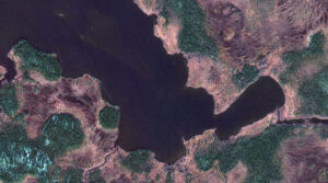
In many parts of the United States, November means snowfall and for outdoor enthusiasts, that means ice fishing. Lac Tantouin in Quebec, Canada, a fairly remote body of water, is located in Cote-Nord County and province of Quebec, in the eastern party of the country, east of Ottawa.
Lac Tantouin happens to be a popular lake among anglers, who revel in the peacefulness of its setting as it’s surrounded by forests and mountains. The lake sits 507 meters above sea level, spans 1.8 square kilometers and is irregularly shaped. The average depth of the lake is 626 meters, with a maximum depth of 2,500 meters. But it’s a bit brisk there with the warmest month being July where the temps still only reach the low 50s and the typically coldest month–December–drops to an average of -4 degrees Fahrenheit.
Surprisingly, Lac Tantouin is so remote and a best kept secret among anglers that there are no reports of common fish species there. Any of our readers care to share what fish they’ve caught there or have heard about in this gem of a lake?
For this month’s Imagery Work Break, we feature a 50-cm color GeoEye-1 image from October 24, 2021. You can see the lake’s curvy banks and deep rich water, beckoning people to fish, kayak or swim–when the weather is a bit warmer, of course.
Have a great rest of your workday! 😊
(Image Courtesy: Maxar. Processed by Apollo Mapping for improved color accuracy and clarity.)

Cricket’s Chirp is created for Apollo Mapping by Ron Ruelle, a Wilmington, NC (formerly Boulder, CO) based cartoonist, lllustrator and teacher. No animals are harmed in the creation of these comics, but Ron sometimes breaks a pencil in frustration. You can see more of his work at www.ronruelle.com
Do you work in urban planning, environmental monitoring, or resource management and are tasked with identifying land use, tracking changes in urban areas, assessing forest health, and planning development projects? If so, high-resolution imagery with its large concentration of pixels for greater detail enables precise analysis and measurement of features not visible in lower-resolution images, allowing for accurate mapping, less need for site visits, and detailed documentation of our real world.
Since its launch in 2024, 30-centimeter (cm), 8-band WorldView Legion is one of the most prolific 30-cm satellite constellations available in the high-resolution satellite imagery sector. With six satellites currently in orbit, the WorldView Legion constellation captures approximately 3.2 million square kilometers (sq km) of high-resolution 30-cm imagery daily which is added to Image Hunter (nearly) instantly. Additionally, its advanced multispectral sensor captures data across eight different wavelengths, offering exceptionally detailed perspectives of Earth’s surface; and facilitating the identification of small objects and the detection of subtle environmental changes in both urban and natural settings. Advanced applications such as bathymetry, vegetation assessment, mineral exploration, and wildfire monitoring are common use cases for 30-cm WorldView Legion satellite imagery.
 A 30-cm WorldView Legion image courtesy of Maxar collected over the NEOM Campus in Saudia Arabia on December 2, 2024. Apollo Mapping has applied custom color balance and image enhancements.
With 90% of the world’s population residing between 45° North and 45° South latitudes, the constellation is optimized for quicker revisit intervals in these regions, while maintaining coverage of higher latitudes with two sun-synchronous satellites. Four WorldView Legion satellites circle the planet in persistent mid-latitude orbits. The WorldView Legion constellation operates across multiple orbital paths with a 10-km footprint at nadir, enabling frequent revisits–in fact, up to 15 times daily in select regions. This increased capacity and revisit rate for the most populated areas of the world creates a robust archive and advanced monitoring capabilities in these crucial regions. The revisit frequency supports comprehensive mapping, robust change detection, and in-depth analysis over extensive geographic areas. These capabilities allow the 30-cm WorldView Legion to support a wide range of geospatial applications, including projects requiring spectral analysis and intense detail.
With six active satellites in orbit, the WorldView Legion constellation stands out for:
- 30-cm panchromatic and 1.2-m 8-band multispectral imaging (coastal, blue, green, yellow, red, red edge 1, red edge 2, NIR).
- Offering four middle-orbit (MIO) satellites concentrated on the most populous areas of the planet.
- Imaging 500,000+ sq km daily from each satellite.
- Delivering an average of three daily accesses to locations between 40° North and South.
- Capturing images throughout the day, not just mornings, thanks to its MIO satellites.
The 30-cm WorldView Legion constellation allows Apollo Mapping to offer increased high-resolution imaging capacity and faster delivery times to customers across various sectors, including defense, mining, oil and gas, engineering, education and research, and humanitarian relief.
You can explore our entire satellite imagery archive today on Image Hunter!
To see how 30-cm, 8-band WorldView Legion imagery can support your next project, or get personalized recommendations, contact our sales team at sales@apollomapping.com now.
If you are searching for medium and high-resolution satellite imagery, the search is over as Image Hunter is the solution you’ve been looking for! Featuring satellite and aerial imagery as well as digital elevation models (DEMs) from a constantly expanding list of 60+ constellations/datasets and 19 vendors, our database contains more than 200-million images/records meaning there is just no other website out there with this breadth of commercial data products. Our interface is slim-lined and modern, loading quickly on all platforms, browsers and operating systems. Further, our database is updated multiple times an hour with the most recent images collected by WorldView-3, Pléiades 1, PlanetScope, SuperView-1 and many more so you are sure to get the most current view of all the imagery and DEM databases we work with. Once you submit your request, an Apollo Mapping representative will be in touch within 4 Illinois business hours to get you the pricing information you need for your project.
So why wait? Give Image Hunter a try now to find the imagery and/or DEM data you need for your next mapping project!
Key Improvement(s) From The Past Month
With the addition of the final two 30-cm, 8-band WorldView Legion satellites last month, it was time to turn our attention to solving a long-know accuracy issue related to all Maxar previews. And with the release of cloud-optimized GeoTIFFs (COGs) this month, we are happy to announce that previews for GeoEye-1, IKONOS, QuickBird, WorldView 1/2/3/4 and WorldView Legion are now more accurate than ever, such a great change!!
Here is a summary of the changes/improvements we made to Image Hunter during the past month:
- Added COG low-resolution previews for all Maxar satellites including GeoEye-1, IKONOS, QuickBird and WorldView-1/2/3/4/Legion.
- We improved shapefile and KMZ downloads of imagery footprints by adding in our new and more precise geometry.
- Extremely long KazEoSat-1 previews did not load, now they do.
- Restored Formosat-2/5 previews.
- Fixed the UTC collection times for most (but not all) SuperView-1/2/Neo-1/3 satellite images.

Data Alert–An Automated Daily Imagery Search
Have you checked out Data Alert which lets you define an area of interest anywhere around the globe, the resolution your project requires and the number of months we should keep the alert active? Once an alert is set up, we check for new data over your area of interest every single day, and send you an email when we find coverage that meets your specifications. We have a short YouTube video with directions to set up a Data Alert, check out the last video; and we have written directions for Data Alert here.
The Sensors Available in Image Hunter
As you might have seen in past articles, we now feature hourly updates (seriously!) of GeoEye-1, KOMPSAT 3/3A, Pléiades 1 and Neo, SPOT 6/7, SuperView-1/2/Neo, WorldView-1/2/3/Legion!
Image Hunter can be accessed 24 hours a day, 7 days a week and is a one-stop shop for every major source of medium and high-resolution satellite (and aerial!) imagery on the market today, including:
- WorldView Legion
- WorldView-4
- WorldView-3
- WorldView-2
- WorldView-1
- QuickBird
- GeoEye-1
- IKONOS
- EROS B
- KOMPSAT-3A
- KOMPSAT-3
- KOMPSAT-2
- Pléiades 1 constellation
- Pléiades Neo constellation
- TerraSAR-X (TerraSAR-X, TanDEM-X and PAZ)
- GEOSAT-1
- GEOSAT-2
- TripleSat
- BJ3A
- BJ3N
- SPOT 1 to 7 constellation
- RapidEye
- GaoFen-2
- GaoFen-1
- ZiYuan-3 01/02 (mono and stereo!)
- FORMOSAT-5
- FORMOSAT-2
- ALOS PRISM (stereo)
- AW3D Standard (DEM)
- SkySat constellation
- PlanetScope constellation (including 5-band SuperDove data)
- SuperView-1 constellation
- SuperView-2
- SuperView Neo-1 01/02
- SuperView Neo-3
- Landsat 1-8
- TeLEOS-1
- DS-EO
- Hexagon (HxGN Content Program aerial imagery) imagery + DEM
- WorldDEM
- WorldDEM Neo
- Vricon DEMs
- Orbita Hyperspectral Satellite (OHS)
- KazEOSat-1
- KazEOSat-2
- Jilin-1 Optical
- Jilin-1 Video (including nighttime imagery)
- Jilin-1 GF/DP
- Jillin-1 KF
- Orbita Video Satellites-1/2/3 (OVS-1/2/3)
- BlackSky Global series
Key Features of Image Hunter
If any of our readers have struggled with other geospatial search engines that are clunky, only query one data source and/or do not provide image previews, then Image Hunter is the solution to your woes as it features:
- Online browsing of satellite and aerial imagery from 19 data providers and 56 satellite and aerial imagery derived datasets.
- Near-instantaneous loading of low-resolution preview imagery with collection date, cloud cover and other key metadata.
- The ability to define your area of interest by address, coordinates, geometric shape or shapefile/KMZ.
- A responsive basemap with street names to provide spatial context when discovering data as well as crowd-sourced updates for the most accurate map possible.
- Exports of the area of interest you create as well as the scenes you select in shapefile or KMZ format.
- Support for all operating systems, and not just our friends with Windows machines!
Image Hunter can be accessed here all day and night, we are excited to find out what you think about our imagery search engine! So if you have any ideas and/or feedback to improve Image Hunter, please let us know at sales@apollomapping.com or (303) 993-3863.
In this monthly feature, we span the globe to examine Our Changing Landscape with a time series of medium-resolution PlanetScope satellite imagery. The PlanetScope constellation dates back to 2016 and collects hundreds of millions of square kilometers of four and eight-band 3-meter imagery daily! In September, we headed to Minnesota where we observed the Camp House Fire that broke out in May 2025 and caused extensive damage. For the October edition of this series, we are looking at the Copiapo River and nearby farming town of Alianza, Chile.
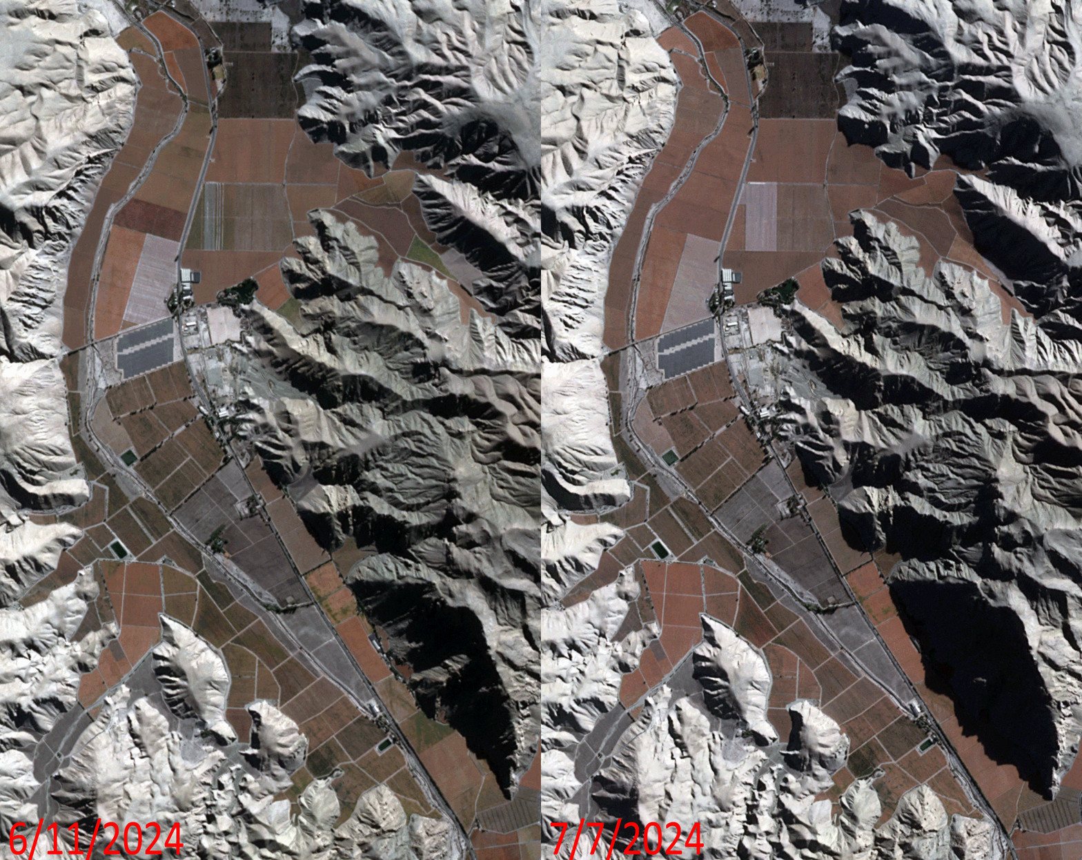 Click on the image above to see an animation of 3-meter natural color PlanetScope image collected over the Copiapo River close to Totoralillo, Chile on June 11 and July 7, 2024. In this animation, you will see how quickly agricultural fields change as many of the fields lay barren in the June image; but in the July 7th image, these same fields have been planted and crops are already emerging! (Images Courtesy: © Planet 2025)
The PlanetScope Microsat Constellation
PlanetScope is a constellation of more than 240 microsats referred to individually as Doves. Each Dove is able to collect up to 20,000 square kilometers (sq km) per day of 3-meter (m) 4-band multispectral (i.e. blue, green, red and near-infrared [NIR]) imagery; and newly launched SuperDoves collect 8-band multispectral adding in valuable red-edge spectral data. Across the constellation, PlanetScope is archiving more than 200 million sq km of medium-resolution imagery a day, making it the go to source for daily imagery over most locations. This massive archive dates back to 2016, offering the most complete and continuous record of spatial data on the planet since the start of the constellation’s ongoing launch schedule. Collecting 3-meter multispectral imagery is the equivalent of ‘high-resolution’ multispectral data imaged by a 75-centimer (cm) satellite (as this satellite would feature 75-cm panchromatic and 3-m multispectral), making PlanetScope an extremely competitively priced option at just $2.25 per sq km. With well registered images and nearly daily collections of most locations, PlanetScope is the ideal imagery source for this current-events focused series, Our Changing Landscape.
Copiapo River in Chile
The Copiapó River, located in the Atacama Desert of northern Chile, plays a crucial role in supporting agriculture in the area despite its arid environment. The river’s water proves essential for irrigating nearby crops, particularly grapes for export, in the Copiapó Valley.
The Copiapó River measures 162 kilometers long and supports the cities of Copiapó, Tierra Amarilla, and Los Loros, which are the main urban centers in the basin with a population greater than 200,000. Fruit exports, viniculture, and vegetable production are the main agricultural activities, accounting for 71% of the total water demand in the basin. On the other hand, 22% of the available water within the basin is used to mine copper, iron, gold, and silver.
However, the region faces increasing water scarcity due to factors including global climate change, mining activities, and agricultural expansion, leading to conflicts over limited water resources. Because water affects many economic, social, and environmental aspects, an interdisciplinary approach is needed to solve current and future water scarcity problems, and to minimize energy requirements in water production, researchers studying the area say.
If you would like to find out more about using 3-meter PlanetScope imagery for your academic studies, engineering projects or any landscape analysis, let us know at sales@apollomapping.com or (303) 993-3863.