
 A 50-cm color SuperView Neo-3 image collected over Washington, DC on December 12, 2024.
Have you noticed 50-centimeter (cm) 8-band SuperView Neo-3 in Image Hunter? If you have used our imagery search engine recently, I bet you have seen tons of SuperView Neo-3 (SVN3) data given its massive footprint that is some 130-kilometers (km) wide, as well as an aggressive speculative tasking program by the vendor!
A part of the SuperView Neo constellation, Neo-3 differentiates itself from its satellite twins, Neo-1 01/02, with 2-meter (m) 8-band multispectral imagery as well as an industry-leading 130-km wide footprint. SuperView Neo-3 also images at 10° or less off-nadir so there is less tilt in the data, which is crucial in areas with tall buildings, trees, and mountains as well as those with deep, narrow passages. A massive 130-km wide footprint allows Neo-3 to collect an impressive 1.4 million sq km of 50-cm 8-band data daily.
Here are a few of the specifications that set SuperView Neo-3 apart from the competition:
- 50-cm panchromatic and 2-m 8-band multispectral, including blue, green, red and near infrared (NIR) plus coastal blue, yellow, red edge and NIR2.
- All images collected at 10° off-nadir or less.
- 130-km wide image footprint.
- 1.4-million sq km per day collection capacity.
So, if you are looking to uplevel your next spectral analysis, 50-cm 8-band SuperView Neo-3 is sure to be one of your go-to satellites.
You can query 50-cm SuperView Neo-3 on Image Hunter at any time! And if you have additional questions about using SuperView Neo-3 for your next mapping project, you can contact us now at sales@apollomapping.com.
It wouldn’t be a stretch to say that I’m both my own worst enemy as well as my own worst influence. The whole trope about all of us having an angel on one shoulder and a devil on the other? Well, I have two devils and no angels. But that’s a story for another today. Instead, I’m going to focus on someone else’s case of being a bad influence on me, or at least that’s how I’m going to frame it. Of course, the bad influence in question is a woman.
 Don’t get consumed by the algorithm, man.(Image retrieved fromhere and comes courtesy of Markus Spiske.)
Back in 2019, I was still buying and listening to CDs. I listened to a lot of music on YouTube as well, and previously had an iTunes account, where years earlier, I’d taken great pains to upload all of my CDs onto it only to have it crash at some point and ultimately be rendered inaccessible to me. I know I spent some money buying songs and albums as well, but I no longer recall which ones. This was some time ago, pre-2010, I believe, long before I’d gotten a “smartphone” (that was in 2014, also under the assault of peer pressure; more on that another day, maybe) and where it was still acceptable to be mostly analog with media and certainly way before it has more recently come back in vogue.
Anyway, this gal I met, we’ll call her “Jean,” she was/is super-hot, super smart, totally her own person, and a nice mixture of bitchiness, humor, and insight, all wrapped in an anti-convention, always against-the-grain bow. Well, we started sharing music and she did so via Spotify, sending me playlists, and through a sense of obligation, I did the same. This caused me to have to set up a Spotify account, and as these things go, the platform quickly displaced my other modes of listening to music. The thing about the free Spotify account that anyone whose had one knows is that it can be really annoying when it comes time to pay the corporate overlords: the commercials pop in at the most inopportune times and they’re always louder than the music that was interrupted. And Spotify knows this. They want to frustrate you completely and then they dangle an offer you can’t refuse in front of your face: three months of unlimited access to their “premium” service (no commercials) for .99¢ – and of course nobody wants to go back after a taste of the good life. So, I didn’t. More than six years later, I’m still on the hook for $12.99/mo.
We’re all aware of how much Spotify exploits the artists they host on their platform. That’s no secret, so any true fan of music (who remains crippled by the convenience that the service provides) should continue to support artists through buying their merch, including CDs/vinyl and official downloads straight from the band. But I’m going to go one further and say that you should get rid of your (paid) Spotify account outright. It’s time to despotify.
Looking at my “liked” songs, I have 797 in my queue. Now, admittedly, there’s a healthy chunk of those that I only liked on a whim and don’t really care if I ever hear again, so let’s just say conservatively that number is 97, leaving me 700 songs I truly like and would like to maintain constant, easy access to. If I were to buy all of those on iTunes at $1 a piece, that would be a large payment, but at least a one-time payment, but I don’t think it would seriously improve the bottom lines of the artists. To do that, I would need to buy the physical copy, which would be cost prohibitive if I’m largely buying singles with no interest in other songs on the album. So, despotification may not help the artist that much, but it would help to break this cycle of streaming life which is taking over more and more of our world. I recently heard that car companies will be offering previously free services, like heated seats, in a streaming capacity. Ridiculous. The more people accept this model, the more it will consume us.
Another related concern with Spotify is its simple role in the algorithm universe. Platforms like it soften us up to being spoon-fed an ever-blander diet of more-of-the-same and do so in a way that is pleasing; it’s a little like turning the heat up slowly on the frog in the pot of water. Before you know it, we’ll be completely detached from any version of our self-curated selves and have devolved into a living Hallmark special. I’m sure there is some apt reference from The Truman Show here, but I haven’t seen the movie recently enough to conjure one up astutely.
What I’ve written here is also nothing new or insightful, as Tim Wu voiced similar concerns in his NYT op-ed in 2018 titled, “The Tyranny of Convenience.” In it, he said that to “resist convenience — not to own a cellphone, not to use Google — has come to require a special kind of dedication that is often taken for eccentricity, if not fanaticism.” He said of convenience that it is “understood and promoted as an instrument of liberation”; that it “has a dark side. With its promise of smooth, effortless efficiency, it threatens to erase the sort of struggles and challenges that help give meaning to life. Created to free us, it can become a constraint on what we are willing to do, and thus in a subtle way it can enslave us.” Spotify, over the six years I’ve subscribed to it, has cost me roughly $1,000, and if I continue to accept it as a fixed expense in my life, it’ll get me for another $5-10K over the duration, still charging me after I’ve died, and no one will be the wiser.
Spotify has “enslaved” me in other ways, too, baking in shortcuts around the hard-earned fun of finding music on my own, and the aforementioned hollowing out of the music industry. That they now host AI musicians is just another form of corporate servitude to watch over us as we continue to feed at the trough of convenience and mass-production. Regarding the latter, Wu said:
The paradoxical truth I’m driving at is that today’s technologies of individualization are technologies of mass individualization. Customization can be surprisingly homogenizing. Everyone, or nearly everyone, is on Facebook: It is the most convenient way to keep track of your friends and family, who in theory should represent what is unique about you and your life. Yet Facebook seems to make us all the same. Its format and conventions strip us of all but the most superficial expressions of individuality, such as which particular photo of a beach or mountain range we select as our background image.
This is what Spotify ultimately does; it takes a mass of individuals and attempts to homogenize us all into an easy-to-sort collection of predetermined groups with all novelty shaved off at the sides until all that remains is a picture-perfect model of the consumer in streamlined fashion, those who also foot the bill at a nominal and ever-increasing fee in perpetuity. We haven’t quite surrendered our consumer role entirely; simply that what we now consume doesn’t quite taste the way we remembered it, nor feel as special as it once did. We’re certainly not producers either; we’re more aptly understood as tech support. Only it comes with a monthly charge to remain on hold.
#despotification, #despotify
Marco Esquandoles
Swimming Downstream
If you are searching for medium and high-resolution satellite imagery, the search is over as Image Hunter is the solution you’ve been looking for! Featuring satellite and aerial imagery as well as digital elevation models (DEMs) from a constantly expanding list of 60+ constellations/datasets and 19 vendors, our database contains more than 500-million images/records meaning there is just no other website out there with this breadth of commercial data products. Our interface is slim-lined and modern, loading quickly on all platforms, browsers and operating systems. Further, our database is updated multiple times an hour with the most recent images collected by WorldView-3, Pléiades 1, PlanetScope, SuperView-1 and many more so you are sure to get the most current view of all the imagery and DEM databases we work with. Once you submit your request, an Apollo Mapping representative will be in touch within 4 Illinois business hours to get you the pricing information you need for your project.
So why wait? Give Image Hunter a try now to find the imagery and/or DEM data you need for your next mapping project!

 Our new Clip Polygon To Image tool is live! Give it a try to automatically calculate the coverage areas of a complex set of imagery from various data vendors and satellite constellations.
Key Improvement(s) From The Past Month
Have you had a chance to test out our new Clip Polygon To Image tool?! If not, you really need to give it a try as we just released a major upgrade! Now, the Clip Polygon To Image tool will automatically calculate the square kilometers of imagery coverage, with sorting by imagery vendor and then by each vendor’s satellites. You can even drag and drop to create new groups and sub-groups as needed to calculate areas for a complex set of mixed satellite imagery. And by the way, we are not done improving this tool! In the next few months, we will release version 3 of the Clip Polygon To Image tool where we will give users the ability to customize the overlap distance between various neighboring groups and subgroups. Oh, and by the way, we knocked out a ton of smaller known bugs, and even changed out our bright blue water for a deeper ocean blue tone on the basemap – we hope you enjoy these changes too.
Here is a summary of the changes/improvements we made to Image Hunter during the past month:
- Version 2 of the Clip Polygon To Image tool is live with automated area calculations by data vendors and satellite constellation. You can now also export clipped polygon geometries as a KMZ, SHP or CSV for each group and subgroup.
- We updated the basemap to use a new deep blue for oceans, rivers and lakes which really makes the landmasses pop.
- Improved 75-cm GeoSat-2 data handling to find some missing images in the API as well as missing metadata.
- A few metadata values for Vantor satellite imagery were reported oddly – we fixed that.
- Sometimes when you clicked a persistent URL with Vantor images, the previews would not load – now they do.
- Kompsat 2/3/3A previews did not load in a few modals – they load now.
Data Alert – An Automated Daily Imagery Search
Have you checked out Data Alert which lets you define an area of interest anywhere around the globe, the resolution your project requires and the number of months we should keep the alert active? Once an alert is set up, we check for new data over your area of interest every single day, and send you an email when we find coverage that meets your specifications. We have a short YouTube video with directions to set up a Data Alert, check out the last video; and we have written directions for Data Alert here.
The Sensors Available in Image Hunter
As you might have seen in past articles, we now feature hourly updates (seriously!) of GeoEye-1, KOMPSAT 3/3A, Pléiades 1 and Neo, SPOT 6/7, SuperView-1/2/Neo, WorldView-1/2/3/Legion!
Image Hunter can be accessed 24 hours a day, 7 days a week and is a one-stop shop for every major source of medium and high-resolution satellite (and aerial!) imagery on the market today, including:
- WorldView Legion
- WorldView-4
- WorldView-3
- WorldView-2
- WorldView-1
- QuickBird
- GeoEye-1
- IKONOS
- EROS B
- KOMPSAT-3A
- KOMPSAT-3
- KOMPSAT-2
- Pléiades 1 constellation
- Pléiades Neo constellation
- TerraSAR-X (TerraSAR-X, TanDEM-X and PAZ)
- GEOSAT-1
- GEOSAT-2
- TripleSat
- BJ3A
- BJ3N
- SPOT 1 to 7 constellation
- RapidEye
- GaoFen-2
- GaoFen-1
- ZiYuan-3 01/02 (mono and stereo!)
- FORMOSAT-5
- FORMOSAT-2
- ALOS PRISM (stereo)
- AW3D Standard (DEM)
- SkySat constellation
- PlanetScope constellation (including 5-band SuperDove data)
- SuperView-1 constellation
- SuperView-2
- SuperView Neo-1 01/02
- SuperView Neo-3
- Landsat 1-8
- TeLEOS-1
- DS-EO
- Hexagon (HxGN Content Program aerial imagery) imagery + DEM
- WorldDEM
- WorldDEM Neo
- Vricon DEMs
- Orbita Hyperspectral Satellite (OHS)
- KazEOSat-1
- KazEOSat-2
- Jilin-1 Optical
- Jilin-1 Video (including nighttime imagery)
- Jilin-1 GF/DP
- Jillin-1 KF
- Orbita Video Satellites-1/2/3 (OVS-1/2/3)
- BlackSky Global series
Key Features of Image Hunter
If any of our readers have struggled with other geospatial search engines that are clunky, only query one data source and/or do not provide image previews, then Image Hunter is the solution to your woes as it features:
- Online browsing of satellite and aerial imagery from 19 data providers and 56 satellite and aerial imagery derived datasets.
- Near-instantaneous loading of low-resolution preview imagery with collection date, cloud cover and other key metadata.
- The ability to define your area of interest by address, coordinates, geometric shape or shapefile/KMZ.
- A responsive basemap with street names to provide spatial context when discovering data as well as crowd-sourced updates for the most accurate map possible.
- Exports of the area of interest you create as well as the scenes you select in shapefile or KMZ format.
- Support for all operating systems, and not just our friends with Windows machines!
Image Hunter can be accessed here all day and night, we are excited to find out what you think about our imagery search engine! So if you have any ideas and/or feedback to improve Image Hunter, please let us know at sales@apollomapping.com or (303) 993-3863.
¡Bienvenidos a marzo! Nosotros en Apollo Mapping estamos gustosos de tenerlos otro mes aquí en los resúmenes españoles del mes de marzo.
Producto Destacado – Monitoreo de Sitios con Descuento con Pléiades Neo de 30 cm
 Una imagen en color de Pléiades Neo de 30 cm recopilada el 28 de abril de 2023 sobre Roozengaarde en el Valle de Skagit, Washington, EE. UU., durante el Festival Anual del Tulipán.
En el mundo en constante cambio de la tecnología geoespacial, Airbus ofrece una solución revolucionaria para colecciones de imágenes repetidas. El Plan Único (OnePlan) de Pléiades Neo de Airbus es una poderosa solución de monitoreo que combina innovación de vanguardia con una capacidad de recolección sin igual a una resolución de 30 centímetros (cm).
Con Pléiades Neo de 30 cm, los clientes de Apollo Mapping pueden monitorear el crecimiento urbano, rastrear cambios ambientales y obtener información valiosa sobre el desarrollo de infraestructuras con una resolución y colecciones repetidas sin precedentes. Sus capacidades de última generación garantizan la entrega oportuna de datos, permitiendo una toma de decisiones informada como nunca antes. Airbus tiene un historial exitoso en la recopilación rápida de imágenes de alta calidad, lo que lo convierte en la mejor opción para aplicaciones de monitoreo.
La solución de asignación de tareas OnePlan de Pléiades Neo cuenta con una estructura de precios flexible, ofreciendo un costo por kilómetro cuadrado con descuento que la convierte en una opción fantástica para una amplia gama de aplicaciones.
Pléiades Neo de Airbus también cuenta con un impresionante tiempo de entrega estándar de 12 horas o menos una vez que las imágenes son recopiladas y descargadas, garantizando que tenga acceso a los datos más recientes cuando más los necesite. ¡Abra un mundo de posibilidades en monitoreo, análisis y toma de decisiones con la asignación de tareas OnePlan de Pléiades Neo a 30 cm de resolución!
Para obtener más información sobre la asignación de tareas OnePlan de Pléiades Neo de 30 cm para el monitoreo de sitios, envíenos un correo electrónico en cualquier momento a sales@apollomapping.com ¡y le responderemos de inmediato!
Colecciones de Imágenes de Alta Resolución – Pléiades 1 – América del Sur, Julio a Septiembre de 2025
 Este mapa muestra las áreas captadas por la constelación Pléiades 1 del 1 de julio al 30 de septiembre de 2025 sobre América del Sur. Tenga en cuenta que en muchos casos, se recopilaron múltiples imágenes sobre la misma área, lo cual es difícil de representar en este mapa estático.
En esta pieza mensual, ofrecemos a nuestros lectores una idea de la cobertura de imágenes de alta resolución recopiladas sobre una geografía durante un período específico. Para ello, seleccionamos una constelación de satélites de alta resolución, un período de tiempo definido y un área de interés, y luego reportamos estadísticas clave sobre la cantidad total de imágenes recopiladas en kilómetros cuadrados (km²). Sin más preámbulos, pasemos a nuestro análisis.
Región Gráfica de Interés: América del Sur más islas costeras
Superficie Terrestre Cubierta: 17,750,994.2 km²
Período de Tiempo: 1 de julio al 30 de septiembre de 2025
Constelación de Satélites de Alta Resolución: Pléiades 1A/1B
Estadísticas de imágenes de la constelación Pléiades 1 – América del Sur
Área total recopilada: 5,213,555.4 km²; 28,334.5 km² por satélite/por día
Área recopilada con menos del 20% de nubosidad y una inclinación de 30° o menos fuera del nadir: 2,435,068.4 km²; 13,234.1 km² por satélite/por día; 46.71% del total
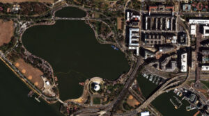
Su Descanso de Trabajo con Imágenes – Cerezos en Flor de Washington D.C. 2025
Amamos los mapas.
Amamos las imágenes.
Amamos los descansos en el trabajo.
¡Esperamos que a usted también le gusten!
En 1885, Eliza Ruhamah Scidmore, de 29 años, regresó a los Estados Unidos tras su primera visita a Japón, donde su hermano George trabajaba para el Servicio Consular de los EE. UU. Durante su estancia, desarrolló una gran apreciación por la cultura japonesa y la belleza de los cerezos japoneses en flor. Regresó con el deseo de presentar a los estadounidenses la belleza de los cerezos japoneses. Durante 24 años, intentó sin éxito convencer a los superintendentes de la Cuenca de las Mareas para que plantaran cerezos allí.
El explorador de plantas del Departamento de Agricultura de los EE. UU., David Fairchild, comenzó a experimentar y abogar por la introducción de cerezos japoneses en flor en los Estados Unidos. Tras plantar con éxito varias variedades en su propiedad personal en Chevy Chase, Maryland, y en las áreas vecinas, comenzó a promover la idea de plantar cerezos japoneses a lo largo de las avenidas de la capital del país. Sus esfuerzos incluyeron el suministro de cerezos a niños para que los plantaran en los patios de las escuelas de Washington, D.C., en el Día del Árbol de 1908.
El día anterior al gran evento, Scidmore habló con Fairchild sobre su sueño de plantar cerezos japoneses en los terrenos recién recuperados del Parque Potomac. Tanto Scidmore como Fairchild comenzaron a trabajar en planes para adquirir árboles para el parque. En la Casa Blanca, la Primera Dama Helen Taft trabajaba en planes para embellecer esta área. Fairchild se ofreció a importar cerezos japoneses para el proyecto. Taft también se había enamorado de los cerezos en flor durante su visita a Japón.
En ese momento, el químico japonés Dr. Jokichi Takamine se enteró del plan para adquirir cerezos para la capital del país. Se encontraba en Washington, D.C. junto con el cónsul general japonés de Nueva York, Kokichi Mizuno. Takamine ofreció a Taft un regalo de 2,000 árboles para la ciudad, en honor a Tokio. Lamentablemente, el primer envío en 1910 incluyó árboles infestados de insectos que tuvieron que ser quemados. Un segundo envío de 3,020 árboles de 12 variedades fue enviado a los EE. UU. en 1912.
Menos de 100 de estos árboles originales sobreviven hoy en día entre los casi 4,000 cerezos que crecen en los Parques West y East Potomac, en los terrenos del Monumento a Washington y en varios otros parques.
Para el Descanso de Trabajo con Imágenes de este mes, presentamos una foto en color mejorado de 30 cm de WorldView-3 del 27 de marzo de 2025. Fue tomada sobre la Cuenca de las Mareas en Washington, D.C., que es la temporada pico de los cerezos en flor. Los cerezos en flor capturados aquí lucen casi blancos en la imagen, con algunos tonos rosados que se destacan.
¡Que tenga un excelente resto de su jornada laboral!
(Imagen cortesía de: Vantor. Procesada por Apollo Mapping para mejorar la precisión del color y la claridad.)
Fernando Gutierrez
Topographic Translator
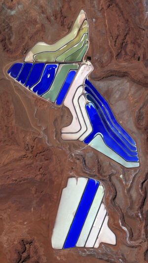
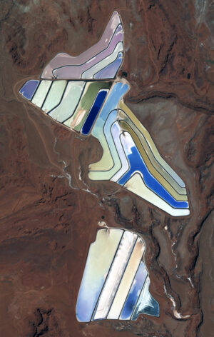 These two satellite images show an overhead view of the Intrepid potash evaporation ponds near Moab, Utah. In the Pléiades Neo 3 30-cm color image from May 12, 2022, we can see the brilliant hues of the evaporation mines. In the second Pléiades 1B 50-cm color image taken on September 9, 2019, the brillant colors of the evaporation ponds are dulled down. These images have custom processing and color balancing applied by Apollo Mapping. PLEIADES © CNES 2026, Distribution Airbus DS.
In February, we looked at the historic Longwood House on St. Helena. This month for the Pléiades 1 – Pléiades Neo Point of Interest, we check out potash evaporation ponds near Moab, Utah.
About the Point of Interest: The Intrepid Potash Cane Creek Mine can be found along the Colorado River, about 20 miles west of Moab, Utah, not far from the Union Pacific Railroad.
Fun Factoids: (1) According to USGS reports, the Paradox Basin contains up to 2.0 billion tons of potash, with the primary mine being the one at Cane Creek. (2) The plant was built by the Texas Gulf Sulphur Company in the early 1960s, opening in 1963 as a conventional underground mine. (3) In 1963, an explosion trapped 25 miners of whom only seven were able to survive by building a barricade to trap fresh air. (4) In 1970, operations were changed to a system that combines solution mining and solar evaporation. River water is pumped into the mine and dissolves the potash, after which the brine solution is pumped to nearby evaporation ponds. (5) Intrepid bought the mine in 2000 from the Potash Corporation of Saskatchewan, which had bought it from Texas Gulf in 1995. (6) The potash mine also is known for its striking blue evaporation ponds visible from State Route 279 (Potash Road) and satellite imagery views.
The 50-cm Pléiades 1 High-Resolution Satellite Constellation
The Pléiades 1 constellation (or at least part of it!) has been in orbit since December 2011 and if you have not had a chance to check out any sample imagery, take a few moments and have a look at the gallery on our website. If you work with high-resolution imagery, you should consider Pléiades 1 and Pléiades Neo for your next geospatial projects.
A variety of Pléiades 1 products are available from both a well-established archive and as a new collection, including 50-centimeter (cm) pansharpened imagery and 50-cm panchromatic – 2-meter (m) 4-band multispectral bundles. We are happy to discuss the technical specifications, pricing and tasking options available with both of these satellite constellations.
The 30-cm Pléiades Neo High-Resolution Satellite Constellation
Pléiades Neo is our newest high-resolution satellite constellation. The first Neo satellite went up in April 2021 and the second in August of the same year. This 30-centimeter resolution constellation will add two more satellites in the next few months and upgrade from daily to intraday revisits. Pléiades Neo has six multispectral bands with 1.2-meter resolution, including a deep blue and two infrared bands, along with a 30-centimeter resolution panchromatic band.
The archive is growing every day, and the satellites are available for new collections, making Pléiades Neo the perfect solution for site monitoring. Check out our beautiful sample images in the Pléiades Neo gallery.
More sample images and technical information about Pléiades 1 can be found on our website here; while the same can be found here for the Pléiades Neo constellation.
The Apollo Mapping sales team can answer any questions you might have about Pléiades 1 and/or Pléiades Neo. We can be reached at (303) 993-3863 or sales@apollomapping.com.
In this monthly article, we travel the world to check out unique, fun and sometimes a bit weird 30-centimeter (cm) color imagery samples from the WorldView constellation. In February, we looked at an art installation called Shadows Travelling on the Sea of the Day located in a remote region of Quatar. For this edition of the 30-cm Color WorldView Image of the Month, we feature an image of the 21st Century Museum of Contemporary Art in Kanazawa, Ishikawa, Japan.
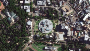 The 21st Century Museum of Contemporary Art in Kanazawa was designed by Japanese architects Kazuyo Sejima and Ryue Nishizawa in 2004. In October 2005, one year after its opening, the museum marked 1,570,000 visitors and earned a spot on the list of the most-visited art museums in the world. The building was built as circle and includes community gathering spaces, such as a library, lecture hall, and children’s workshop with spaces in the middle. The exhibition areas include numerous galleries with multiple options for division, expansion, or concentration. The galleries range from featuring bright daylight through glass ceilings to spaces with no natural light source. All the walls of the circular museum are made of glass and the building features five gates, all pointing toward different parts of the city. The collection of the 21st Century Museum of Contemporary Art focuses on works produced since 1980 that “propose new values.” Artists in the collection are encouraged to produce site-specific installations that become “closely associated with the Kanazawa area.” The 21st Century Museum of Contemporary Art offers visitors experiences that can’t be found anywhere else. Highlights include Leandro Erlich’s The Swimming Pool, which enables visitors to feel as if they’re standing at the bottom of a swimming pool, and a wall decorated with flowers gathered from the suburbs of Kanazawa. Last year marked the museum’s 20th anniversary and there were several special exhibits. The museum also focuses on art communication with programs aimed at revitalizing local culture through the performing arts and programs that give citizens a role in making the Museum a “town square,” where diverse people freely come and go. On occasion, activities are taken out into the city in programs open to limitless participation, such as creative activities centered on artist collaborations with the community. In the 30-cm WorldView Legion image featured here, we can clearly see the circular shaped museum with various roof peaks that offer the varying ceiling heights within the displays. The museum is surrounded by trees and buildings in an eclectic mix. This 30-cm WorldView Legion image was collected on August 28, 2025, and has custom processing and color balance applied by Apollo Mapping. (Satellite Imagery © 2026 Vantor)
30-cm WorldView-3 (WV3) launched in late 2014, WorldView-4 (WV4) launched in late 2016 and then the first WorldView Legion satellites launched in 2024. Taken together, this is the most advanced satellite constellation the commercial marketplace has ever had access to. Here are a few of the features that really set these satellites apart from the competition:
- Improved Resolution
- Higher resolution means you can see more detail in WorldView imagery.
- Data collected at nadir will have 31-centimeter (cm) panchromatic, 1.24-meter (m) visible and near infrared, 3.7-m SWIR (WV3 only) and 30-m CAVIS (WV3 only) bands.
- Additional Spectral Bands
- If spectral analysis is part of your project, then no other satellite can match WorldView-3 and WorldView Legion with their 8 bands of visible and near-infrared data; and then 8 shortwave infrared bands (WV3 only) which are crucial for geological studies.
- Better Positional Accuracy
- With accuracies of 3.5-m CE90% or better (without ground control even!), the 30-cm WorldView constellation has no rivals for its enhanced positional accuracy.
- Daily Revisits
- With multiple WorldView-3 and WorldView Legion satellites orbiting our planet, daily revisits are available for most locations.
- WV4 is no longer collecting new imagery.
- Increased Collection Capacity
-
- WV3/4 feature 13.1-km swath widths (at nadir) with the ability to collect up to 680,000 square kilometers (sq km) of high-resolution data per day per satellite (though WV4 is dead now).
- WorldView Legion features six 30-cm satellites, significantly boosting the collection capacity of this leading high-resolution constellation.
If you are interested in WorldView-3, WorldView-4 and/or WorldView Legion imagery for your next project, please let us know by phone, 303-993-3863, or by email, sales@apollomapping.com.
You can also find more WV3 samples and technical information on our website here; WV4 samples and information can be found here; and then finally here is more information about WorldView Legion.

Cricket’s Chirp is created for Apollo Mapping by Ron Ruelle, a Northwest Ohio (formerly Boulder, CO) based cartoonist, lllustrator and teacher. No animals are harmed in the creation of these comics, but Ron sometimes breaks a pencil in frustration. He has a new collection of his weekly Skelton Comics available at www.ronruelle.com
A 30-cm color Pléiades Neo image collected on April 28, 2023 over Roozengaarde in the Skagit Valley, Washington, USA during the annual Tulip Festival.In the ever-changing world of geospatial technology, Airbus offers a groundbreaking solution for repeat imagery collections. Airbus’ Pléiades Neo OnePlan is a powerful monitoring solution that combines cutting-edge innovation with unparalleled collection capability at 30-centimeter (cm) resolution.
With 30-cm Pléiades Neo, Apollo Mapping clients are able to monitor urban growth, track environmental changes, and gain valuable insights into infrastructure development with unprecedented resolution and repeat collections. Its state-of-the-art capabilities ensure timely data delivery, enabling informed decision-making like never before. Airbus has a successful track record of quickly collecting beautiful imagery, making it the best option for monitoring applications.
The Pléiades Neo OnePlan tasking solution has a flexible pricing structure, offering a discounted per-square-kilometer cost that makes it a fantastic choice for a wide range of applications.
Airbus’ Pléiades Neo also boasts an impressive standard delivery time of 12 hours or less once the imagery is collected and downlinked, ensuring that you have access to the latest data when you need it most. Unlock a world of possibilities in monitoring, analysis, and decision-making with 30-cm resolution Pléiades Neo OnePlan tasking.
To find out more about 30-cm Pléiades Neo OnePlan tasking for site monitoring, send us an email at any time to sales@apollomapping.com and we will get right back to you!