
During March we traveled to the site of a canceled EPL football match, and for this April’s Pléiades 1–SPOT 6/7 Stadium of the Month the theme of coronavirus-impacted events continues with a look at a site of the now canceled IIHF Men’s Ice Hockey World Championship in Zurich, Switzerland, Hallenstadion.

 A 50-cm color image of Hallenstadion in Zurich, Switzerland collected on July 23, 2019 by Pléiades 1A; and then a 1.5-m SPOT 7 image of the same stadium collected on September 20, 2019. These images have custom processing and color balancing applied by Apollo Mapping. PLEIADES © CNES 2020, Distribution Airbus DS. SPOT © Airbus DS 2020.
About the Venue: Located about 4.5 kilometers (3 miles) north of Lake Zurich in the Oerlikon district of Zurich, Switzerland, the concept for Hallenstadion was inspired by a bike race canceled due to rain in 1932. A foundation headed by Heinrich Hirzel helped raised the funds for Europe’s then largest sports arena which broke ground on May 2, 1938 and opened for its first bike event on November 4, 1939. Eleven years later, on November 18, 1950, an ice rink opened in Hallenstadion bringing the total construction price to 3 million Swiss Francs (about $3.1 million). On May 29, 2004, Cher bookended the music concert series which started in 1959 with Louis Armstrong, after which the stadium was closed for major renovations, including the addition of a conference center and luxury seating. Hallenstadion reopened in July 2005 after some 145 million Swiss Francs (about $150.2 million) in upgrades.
Fun Factoids: (1) On March 21st, the International Ice Hockey Federation (IIHF) canceled the 16-team Men’s Ice Hockey World Championship that was scheduled for games in both Vaudoise Aréna (Lausanne) and Hallenstadion from May 8th to the 24th. The last world rankings had Canada, Russia and Finland respectively in the top three spots of men’s international ice hockey play. (2) Hallenstadion’s seating capacity ranges from 11,200 to 15,000 seats depending on the event it hosts–however the future of the arena is unclear as the ZSC Lions, Zurich’s professional ice hockey team, is set to move out at the end of 2021/2022 season for a new arena being built close by. (3) After 45 years and multiple albums, KROKUS played their last European show at Hallenstadion on December 12, 2019–okay I admit that I have never heard of them J (4) When opened, Hallenstadion featured a wooden, 250-meter bicycle track that was reputed to be one of Europe’s fastest tracks!
The Pléiades 1 High-Resolution Satellite Constellation
The Pléiades 1 constellation (or at least part of it!) has been in orbit since December 2011 and if you have not had a chance to check out any sample imagery, take a few moments and have a look at the gallery on our website. If you work with high-resolution imagery, you should consider Pléiades 1 for your next geospatial project.
A variety of Pléiades 1 products are available from both a growing archive and as a new collection, including 50-centimeter (cm) pansharpened imagery and 50-cm panchromatic–2-meter (m) 4-band multispectral bundles. We are happy to discuss the technical specifications, pricing and tasking options available with this satellite constellation.
The SPOT Medium-Resolution Satellite Constellation
The SPOT medium-resolution constellation consist of seven satellites launched from 1986 to 2014 with the most recent additions, SPOT 6 and SPOT 7, launching in 2012 and 2014 respectively. SPOT 6 and SPOT 7 are twin satellites offering 1.5-m panchromatic and 6-m 4-band multispectral data with a massive footprint at 60-kilometers (km) wide. For projects requiring recent archive coverage or rapid new collections of medium-resolution data, SPOT 6/7 should be one of your top imagery sources!
More sample images and technical information about Pléiades 1A and 1B can be found on our website here; while the same can be found here for the SPOT constellation and specifically about SPOT 6/7.
The Apollo Mapping sales team can answer any questions you might have about Pléiades 1 and/or any of the SPOT satellites. We can be reached at (303) 993-3863 or sales@apollomapping.com.

Cricket’s Chirp is created for Apollo Mapping by Ron Ruelle, a Boulder, Colorado based cartoonist, lllustrator and teacher. No animals are harmed in the creation of these comics, but Ron sometimes breaks a pencil in frustration. You can see more of his work at www.ronruelle.com
I never remember my dreams, that is unless I wake up in the middle of one. Usually this happens if REM sleep unfortunately aligns with my alarm going off–which leaves me quite groggy for the day; but it can also happen if I’m having a bad dream (I don’t refer to them as nightmares any longer because I’m not a child). On rare occasions, I’ll wake up in a sweat or panic; not often at all, but it has happened a handful of times over the years. Sometimes I attribute it to eating something fatty or spicy late (I typically don’t eat after 8pm as a rule), sometimes because I drank too much booze, and sometimes it may simply be circumstantial, like something is buried in the recesses of my mind and it only comes out when I’m asleep and unable to ward it off. Don’t let down your guard, I guess. But if you choose not to sleep to keep the wolves at bay, then I imagine you’ll have bigger problems down the line.
There are only a few dreams I vividly remember from my childhood, three to be exact: two were bad and one was good and recurred often for several years. I miss it, and occasionally think about it. I sometimes wish I could summon it to return. But let’s get the bad ones out of the way. The first one involved Bert and Ernie (yes, those lovable characters from Sesame Street). For some reason we were in an Egyptian tomb and they were dressed as pharaohs. I remember them singing something, and for some reason it had something to do with urination. I’m not sure if I was still in my bed in the tomb, or maybe was watching from afar, but either way they were singing that they were going to pee in my bed. It was frightening and confusing. I woke up immediately, having peed the bed. They got me. The second one was the old falling dream. I was on a cliff, maybe battling it out with someone, and before you knew it, I was falling off the edge to a very rocky seashore below. I’d always heard that if you died in your dreams you died in real life; has that been verified? Anyhow, I woke up mid-fall, sweating and out of breath, happy to be alive still.
 Breathe in, breathe out. All your troubles will disappear when you sleep…
The good dream I remember from childhood involved me standing in an empty, wide-open field. Eventually I would start running as fast as I could in circles, then stick out my arms and leap into the air to glide. I wasn’t flying, but I simply would get caught in a stiff draft and soar with the birds in a circle as I looked down below me. I don’t remember ever landing, I don’t remember any words, music or sounds, just bliss and smiles, then I’d wake up, a little fuzzy, but content. This happened several times, maybe half a dozen, over a few years up until high school. I don’t know why it started or why it stopped, but I remember it clear as day. It always makes me smile when I think about it again. And that’s it. I don’t remember any other dreams from childhood, and I’ve been an adult for a whole lot longer, and I don’t remember anything from that period. I have written down a few fragments over the years, but mostly those are incoherent. Hell, I don’t even know where I put those scraps of paper, so I guess it was a wasted effort.
Well, I’ve heard that ever since COVID-19 took hold, people have been reporting strange dreams. Obviously, a lot of this has to do with their worries, I’m sure, but not all dreams evidence a clear link between the cause and the outcome. Many years ago, I use to induce dreams; as I became semi-lucid in my bed, I would implant a thought to take with me into dreamland. I think it worked a few times, but as I stated, it’s all lost to me now if it did. But for our current times, I imagine if you fall asleep scared and anxious about the pandemic, it’s bound to affect your dream-state.
Last month I told you about a few trips, one I had just taken, and one I was about to–which obviously got cancelled. Well, after I got back from the one that I made, it was about the time the pandemic was really starting to ramp up. Everyone had started to get worked up into a frenzy, and misinformation and ambiguity was everywhere. As we started to learn about symptoms, I, like many others I knew, started to feel every little thing as a sign I’d caught it. The slightest headache, the slightest stomach ache, the slightest scratchy throat; you name it and it became the beginning of the end. These things I normally would have paid no attention to, well, they’d worked their tentacles into me and I was a little worried. And I’m not the type of person who worries over the big things. Typically, I only stress about the things that don’t matter; can’t explain it, just the way it’s always been. Well, I had a scheduled dentist appointment, just before those got shut down across the board, and they did a little screening and temperature check when I arrived; all good. It appears that those little aches and worries were nothing to fret about. At least not for now. At least as long as they did the check right…
Fast-forward and here we are all tucked away in our homes, practicing good “social distancing” (I hate that term already) and trying to “flatten the curve” (I hate that one also). Today, as I write, I glare over at the other windows open on my computer and I see an article about how Generation X is doing the best with what’s going on: we were the first latchkey kids, didn’t have social media or the internet growing up, were used to filling our time on our own, and had really lame toys to distract which caused us to use our imagination. Pet Rock anyone? Yeah, that was us. It helps, of course, that I’m a loner and don’t care much for other people unless it’s on my own terms, and I’m very happy being in charge of what my terms are these days. I don’t know; give it a few more weeks and I may go crazy without enough social contact, but so far, so good.
However, having control over your time and who you do or don’t interact with is one thing, having control over your dreams is another. I’ve been pretty good about maintaining a normal schedule of when I go to bed and get up, what I eat, how much I drink, the amount of exercise I get, etc., and I’ve also been paring back my news intake significantly. Still, I do check in a few times a day, so whatever’s out there permeates through the thin cracks of my eyes and mind and does what it will to my thinking. When I go to sleep, it’s a looter’s paradise for corruption and dark thoughts, and while I’ve had way more good nights of sleep than not, I’ve had a few where I wake up with beads of sweat on my forehead. I don’t recall what instigates the unease, but I can imagine… One of these days I’ll try to capture my dreams again, to make sense of what apparently torments me in my sleep. But as I look down at my dog right now, her eyes flutter, her body shakes, her tail pounds, and her voice quivers; is she chasing? Being chased? I don’t know. But she wakes up, licks her lips, yawns, and goes back to bed. The dreams won’t keep her from what she’s set out to do, at least not today…
Marco Esquandoles
The Sandman
As many of you have heard already, the 5-meter (m) 5-band RapidEye constellation was retired in March 2020 by Planet. While we are always sad to see a constellation go offline, we were equally excited to see Planet announce the availability of 3-m PlanetScope with a new fifth band, that being red edge! So as RapidEye is retired, new SuperDoves are stepping in to fill the void of regional-coverage red edge satellite imagery, and with the added bonus of 3-meter resolution!
Speaking of 5-m RapidEye data, we feature a bittersweet image here as it is the last one collected by the constellation and boy it’s a pretty one! Collected on March 26, 2020 over the northwestern coast of New Caledonia, the first sample here is a low resolution overview of the most cloud-free portion of this data over the city of Voh and Chasseloup Bay.
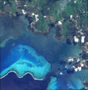
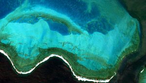
This 5-meter RapidEye data was collected over New Caledonia on March 26, 2020 and is the last image ever collected by the constellation. (Image Courtesy: Planet)
The second is a full-resolution view of the reef, Grand Récif de Gatope, which is just to the south-west of the bay.
As you might expect, new 5-band 3-m PlanetScope imagery is already searchable in Image Hunter! Just head to the image filters located in the collapsible menu on the left of your screen, then press the Select Datasets button and the Planet submenu. From here you can see all of searchable Planet products, including 5-band PlanetScope (listed as PS SuperDove OrthoTile). Currently, 5-band PlanetScope imagery is only available in the ortho tile product format.
Oh and of course, you might be thinking about pricing–and as an added bonus, there is no additional cost for 5-band PlanetScope imagery! If you are interested in a current price list that includes 3-meter PlanetScope imagery, send us an email at sales@apollomapping.com and we will get right back to you. You can also check out additional product specification and full-resolution samples of PlanetScope imagery here.
A short video showing you how to find 5-band SuperDove PlanetScope satellite imagery in Image Hunter.
Estos datos de 5-m RapidEye fueron recolectados sobre Nueva Caledonia el 26 de marzo, 2020, y son las últimas imágenes recopiladas por la constelación. (Imagen Cortesía: Planet)¡Hola y gracias por sintonizar a esta versión de Los Resúmenes Españoles!
5-band 3-meter PlanetScope Now Available & Searchable on Image Hunter + Last 5-meter RapidEye Image Ever Collected!
Como muchos de ustedes ya han escuchado, la constelación de 5-metros (m) 5-bandas RapidEye estaba retirada en marzo de 2020 por Planet. Mientras estamos tristes de ver el final de esta constelación, estamos emocionados de ver que Planet ha anunciado la disponibilidad del Planetscope 3-m, ¡con una nueva quinta banda! Así como RapidEye se retiró, nuevos SuperDoves están interviniendo para llenar el vacío. Aquí presentamos la última imagen recolectada por la constelación RapidEye, y wow, ¡qué bonito!
Como se podría esperar, las imágenes nuevas de 5-bandas 3-m PlanetScope ya se puede buscar en Image Hunter. Dirígete a los filtros de imagen en el lado izquierdo de la pantalla y haga clic en el botón ‘Select Datasets’ y el submenú ‘Planet.’ Ahora, imágenes de 5-bandas PlanetScope solo son disponibles en el formato de producto de azulejo orto.
Un video corto que muestra cómo puedes encontrar las imágenes satelitales de 5-bandas SuperDove PlanetScope en Image Hunter.

Product Update–20-cm/40-cm DSMs over Europe & USA!!
Algunas veces especificaciones de nuevos productos evolucionan y estamos felices de anunciar una evolución que significativamente mejoró a nuestros modelos de elevación digital (DEMs) sobre los EE. UU. y Europa. Los DEMs de Hexagon ahora son disponibles como modelos de superficie digital (DSMs) de 20-cm y 40-cm desde un archivo que cubre gran parte de Europa y los EE. UU.
Aquí está un resumen detallado de las especificaciones del producto Hexagon DSM:
- Tipo de DEM: Modelo de superficie digital (DSM)
- Resolución de DSM*: Igual a la distancia nominal de muestreo de tierra estéreo (GSD), comúnmente 20-cm o 40-cm
- Formatos de Productos de DSM: 1X GSD estéreo, nube de puntos de resolución completa; 2X GSD estéreo, nube de puntos sin ruido; 4X GSD estéreo, nube de puntos de resolución intermedia; y rejilla de trama de 5-m
- Cubierta Geográfica: Europa y los EE. UU. (como disponible)
- Precisión Horizontal (XY): 2-m RMSE, 2.6-m CE90%
- Precisión Vertical (Z): 2X GSD estéreo
- Formato de Archivo: LAZ (nube de puntos), o GeoTIFF (rejilla de trama) comprimido
- Sistema Coordinado (horizontal, vertical): UTM IRTF2008, EGM08 (Europa); UTM NAD83, NAV88 (EE. UU.)
Mientras las especificaciones del producto para los DSMs han cambiado, las especificaciones del producto Hexagon estéreo permanecen sin cambios.
- Resolución de Par Estéreo: 15-cm y 30-cm
- Cubierta Geográfica: Europa y los EE. UU. (como disponible)
- Bandas Espectrales: Color natural y color falso (CIR)
- Profundidad de Bits: 16-bit
- Precisión Horizontal (XY): 5-m RMSE, 1.07-m CE90%
- Formato de Producto: GeoTIFF con modelos estéreo apropiados y parámetros de orientación exterior
- Sistema Coordinado: UTM IRTF2008 (Europa), UTM NAD83 (EE. UU.)
- Distancia Nominal de Muestreo de Tierra Estéreo (GSD): ~20-cm para ubicaciones aéreas de 15-cm; ~40-cm para ubicaciones de 30-m
- Sistema de Control: GPS/IMU a bordo más ajuste de paquete con puntos de control de tierra
*Por favor nota que, en algunos casos limitados, conjuntos de datos de elevación regional de Hexagon son disponibles a resoluciones reducidas para ambos DSM y productos de par estéreo.

50-cm Vricon 3D Surface Models and DEMs over Arizona (and the World)!
El desierto de Sonora de Arizona tiene un paisaje áspero y accidentado. Estas montañas, valles, y cauces son bellamente representadas en los modelos de elevación digital (DEMs) y los datos 3D de Vricon. Los migrantes que pasan por este paisaje a menudo viajan por los valles durante la noche y se refugian en las montañas durante el día caluroso. Con este entendimiento, sus patronas de movimiento son fácilmente predecibles. Los datos en 3D dan vida a esta historia y permiten a los espectadores comprender el terreno de una manera que solo las personas que han estado allí pueden entender. La cobertura extensiva de los datos 3D y los DEMs permite la visualización y análisis de vastas extensiones de tierra que la gente de otra manera nunca podría visitar.
Puedes buscar en cualquier punto todos los productos de modelos de 50-cm 3D y DEMs con Image Hunter.
If you are searching for medium and high-resolution satellite imagery, the search is over as Image Hunter is the solution you’ve been looking for! Featuring satellite and aerial imagery as well as digital elevation models (DEMs) from a constantly expanding list of 48 sensors/datasets and 17 vendors, our database contains more than 70-million images/records meaning there is just no other website out there with this breadth of commercial data products. Our interface is slim-lined and modern, loading quickly on all platforms, browsers and operating systems. Further, our database is updated multiple times an hour with the most recent images collected by Maxar-DigitalGlobe, Airbus, Planet and more so you are sure to get the most current view of all the imagery and DEM databases we work with. Once you submit your request, an Apollo Mapping representative will be in touch within 4 Colorado business hours to get you the pricing information you need for your project.
So why wait? Give Image Hunter a try now to find the imagery and/or DEM data you need for your next mapping project!
Key May 2020 Improvement(s)

The past month of Image Hunter improvements have focused on reconnecting broken data updates (ugh!) and then on Planet data, including RapidEye and PlanetScope. While RapidEye is dead, we broke our database into Scenes and OrthoTiles making product ordering much easier–this also helped us recover tens of thousands of missing image dates only produced as one of these product types. With regards to PlanetScope, we also added 3-meter 5-band SuperDove data to Image Hunter–pretty cool! And of course, we continue to work on adding in new satellites to our database but that is always slow moving.
Here is a summary of the changes/improvements we made to Image Hunter in the past month:
- Added 3-meter 5-band PlanetScope SuperDove OrthoTile data.
- Changed some wording in the Data Selector menu.
- Broke out RapidEye data into 6.5-m Scenes and 5-m OrthoTile product types.
- Recovered nearly 100,000 dates of missing RapidEye imagery.
Data Alert–An Automated Daily Imagery Search
Have you checked out Data Alert which lets you define an area of interest anywhere around the globe, the resolution your project requires and the number of months we should keep the alert active? Once an alert is set up, we check for new data over your area of interest every single day, and send you an email when we find coverage that meets your specifications. We have a short YouTube video with directions to set up a Data Alert, check out the last video; and we have written directions for Data Alert here.
The Sensors Available in Image Hunter
As you might have seen in past articles, we now feature hourly updates (seriously!) of GaoFen 1/2, GeoEye-1, KOMPSAT 2/3/3A, Pléiades 1, SPOT 6/7, SuperView-1, TripleSAT, WorldView-1/2/3/4 and ZiYuan-3!
Image Hunter can be accessed 24 hours a day, 7 days a week and is a one-stop shop for every major source of medium and high-resolution satellite (and aerial!) imagery on the market today, including:
- WorldView-4
- WorldView-3
- WorldView-2
- WorldView-1
- QuickBird
- GeoEye-1
- IKONOS
- EROS B
- KOMPSAT-3A
- KOMPSAT-3
- KOMPSAT-2
- Pléiades 1 constellation
- Deimos-1
- Deimos-2
- TripleSat
- SPOT 1 to 7 constellation
- RapidEye
- GaoFen-2
- GaoFen-1
- ZiYuan-3 01/02 (mono and stereo!)
- FORMOSAT-5
- FORMOSAT-2
- ALOS PRISM (stereo)
- AW3D Standard (DEM)
- SkySat constellation
- PlanetScope constellation (including 5-band SuperDove data)
- SuperView-1 constellation
- Landsat 1-8
- TeLEOS-1
- Hexagon (HxGN Content Program aerial imagery)
- WorldDEM
- Vricon DEMs
- Orbita Hyperspectral Satellite (OHS)
- KazEOSat-1
- KazEOSat-2
Key Features of Image Hunter
If any of our readers have struggled with other geospatial search engines that are clunky, only query one data source and/or do not provide image previews, then Image Hunter is the solution to your woes as it features:
- Online browsing of satellite and aerial imagery from 15 data providers and 44 satellite and aerial imagery derived datasets.
- Near-instantaneous loading of low-resolution preview imagery with collection date, cloud cover and other key metadata.
- The ability to define your area of interest by address, coordinates, geometric shape or shapefile/KMZ.
- A responsive basemap with street names to provide spatial context when discovering data as well as crowd-sourced updates for the most accurate map possible.
- Exports of the area of interest you create as well as the scenes you select in shapefile or KMZ format.
- Support for all operating systems, and not just our friends with Windows machines!
Image Hunter can be accessed here all day and night, we are excited to find out what you think about our imagery search engine! So if you have any ideas and/or feedback to improve Image Hunter, please let us know at sales@apollomapping.com or (303) 993-3863.
When it comes to rugged terrain, Arizona’s Sonoran Desert is about as bleak and rugged as it gets. This stretch of the US/Mexico border is a major route for immigrants hoping to enter the United States undetected.
The mountain spines, valleys and riverbeds that separate them are beautifully represented in Vricon’s 3D data and digital elevation models (DEMs). As migrants traverse this landscape, they often travel in the valleys under the cover of darkness and shelter in the mountains during the oppressive heat of the day. With this understanding, their movement patterns can be more easily predicted. 3D data really brings this story to life and enables the viewer to understand the terrain in a way that only people who have been there understand.
This is a stretch of Arizona that not many tourists visit, its unique beauty is dotted with Saguaro cactus and Teddy Bear cholla. Wildlife like rattlesnakes and jackrabbits are common. Being able to visit this stretch through Vricon’s highly-accurate 3D surface models and DEMs is really an incredible experience.
Vricon’s extensive 3D and DEM coverage allows visualization and analysis of vast expanses of land that the viewer might otherwise never be able to experience. Because of the unique relationship with Maxar and access to commercial satellite imagery, highly accurate models can be built anywhere in the world, from the emptiest deserts to the tops of snowy mountains.
You can search for Vricon’s entire product suite of 50-centimeter 3D models and DEMs anytime using Image Hunter. If you have any additional questions about Vricon’s elevation products, including specific pricing and coverage inquires, you can email us at sales@apollomapping.com and we would be happy to help out!
 The Mars Perseverance rover is equipped with an advanced, drone-like helicopter. (Credits: NASA/JPL-Caltech)
For decades, humans have super-sized everything they could get their hands on, from French fries to rockets to double-decker planes. In recent years, we’ve seen a shift to the micro- and even nano-level in design and manufacturing. There are real benefits to shrinking technology for space exploration. Getting anything into space is expensive, the heavier the payload the more rocket fuel we need to get it out of Earth’s atmosphere. Until manufacturing is moved to space, this will be a constant challenge. Bringing objects down to size maximizes the payload potential and reduces cost.
Millions of dollars are spent to create a single rover for Mars. If something goes wrong at any stage, the machine and the investment is lost. Researchers at the School of Engineering and Applied Science at the University of Pennsylvania are testing nanocardboard to collect data without moving parts. Shaped like a credit card, the aluminum-oxide surface is corrugated with tiny channels. As one side heats in the sun, cooler air underneath is forced through the narrow channels, lifting the plates off the ground.
What can a small flyer, that weighs less than a third of a milligram, do for us on another planet? In Mars’ reduced gravity, the flyers are more efficient and can carry up to ten times their own weight; to be fair, it’s still not a lot. But with the weight and cost low, they can deploy many flyers at the same time, carrying a variety of simple chemical sensors to detect methane and water. It’s been suggested the flyers could carry small particles back to a rover, like a dog rolling in mud (hopefully it’s mud).
 The Honey, I Shrunk the NASA Payload is looking for new designs for Mars rovers in miniature. (Credit: NASA)
NASA is onboard with this concept and issued the Honey, I Shrunk the NASA Payload challenge to the public to help lighten their load. Specifically, they’re looking for small rovers that can identify lunar resources for future missions, reducing the need to ship in supplies. The rovers will search for resources for building materials, water, breathable air and food production. Think of it as small scouting missions.
NASA is looking for rover concepts the size of a sandwich that can hitch a ride to the Moon on the next payload. Doing more with less is the name of the game and NASA wants your project ideas and prototypes for a cut of the $160,000 prize bucket.
Interested parties can submit their ideas through HeroX.