
If you are searching for medium and high-resolution satellite imagery, the search is over as Image Hunter is the solution you’ve been looking for! Featuring satellite and aerial imagery as well as digital elevation models (DEMs) from a constantly expanding list of 48 sensors/datasets and 17 vendors, our database contains more than 100-million images/records meaning there is just no other website out there with this breadth of commercial data products. Our interface is slim-lined and modern, loading quickly on all platforms, browsers and operating systems. Further, our database is updated multiple times an hour with the most recent images collected by Maxar-DigitalGlobe, Airbus, Planet and more so you are sure to get the most current view of all the imagery and DEM databases we work with. Once you submit your request, an Apollo Mapping representative will be in touch within 4 Colorado business hours to get you the pricing information you need for your project.
So why wait? Give Image Hunter a try now to find the imagery and/or DEM data you need for your next mapping project!

Key July 2020 Improvement(s)
In the past month our focus was divided on Image Hunter–with part of it focused on bug and update fixes; and then the other part working with two vendors to get APIs in place for new high-resolution data sources, woot woot! We are hoping to drop the two new high-resolution satellites in the coming month or two–stayed tuned there J As for the fixes and changes this month, we think the most exciting is our new button, Copy IDs, in the Review/Save menu which saves you time when trying to copy a long list of image IDs!
Here is a summary of the changes/improvements we made to Image Hunter in the past month:
- Added the ability to copy selected image catalogue IDs in the Review/Save menu.
- Improved the visibility of PlanetScope in searches for 3-meter or greater resolution and changed the default search when it’s added.
- Hexagon data that is yet to be released but is coming soon is now marked as such.
- Persistent links sometimes did not load selected previews, that is fixed now!
- Improved the handling of Vricon DEM data in searches.
- Updated SkySat to show 50-cm in the Data Selector.
- Fixed some broken data updates, it’s a constant battle!
Data Alert–An Automated Daily Imagery Search
Have you checked out Data Alert which lets you define an area of interest anywhere around the globe, the resolution your project requires and the number of months we should keep the alert active? Once an alert is set up, we check for new data over your area of interest every single day, and send you an email when we find coverage that meets your specifications. We have a short YouTube video with directions to set up a Data Alert, check out the last video; and we have written directions for Data Alert here.
The Sensors Available in Image Hunter
As you might have seen in past articles, we now feature hourly updates (seriously!) of GaoFen 1/2, GeoEye-1, KOMPSAT 2/3/3A, Pléiades 1, SPOT 6/7, SuperView-1, TripleSAT, WorldView-1/2/3/4 and ZiYuan-3!
Image Hunter can be accessed 24 hours a day, 7 days a week and is a one-stop shop for every major source of medium and high-resolution satellite (and aerial!) imagery on the market today, including:
- WorldView-4
- WorldView-3
- WorldView-2
- WorldView-1
- QuickBird
- GeoEye-1
- IKONOS
- EROS B
- KOMPSAT-3A
- KOMPSAT-3
- KOMPSAT-2
- Pléiades 1 constellation
- Deimos-1
- Deimos-2
- TripleSat
- SPOT 1 to 7 constellation
- RapidEye
- GaoFen-2
- GaoFen-1
- ZiYuan-3 01/02 (mono and stereo!)
- FORMOSAT-5
- FORMOSAT-2
- ALOS PRISM (stereo)
- AW3D Standard (DEM)
- SkySat constellation
- PlanetScope constellation (including 5-band SuperDove data)
- SuperView-1 constellation
- Landsat 1-8
- TeLEOS-1
- Hexagon (HxGN Content Program aerial imagery)
- WorldDEM
- Vricon DEMs
- Orbita Hyperspectral Satellite (OHS)
- KazEOSat-1
- KazEOSat-2
Key Features of Image Hunter
If any of our readers have struggled with other geospatial search engines that are clunky, only query one data source and/or do not provide image previews, then Image Hunter is the solution to your woes as it features:
- Online browsing of satellite and aerial imagery from 15 data providers and 44 satellite and aerial imagery derived datasets.
- Near-instantaneous loading of low-resolution preview imagery with collection date, cloud cover and other key metadata.
- The ability to define your area of interest by address, coordinates, geometric shape or shapefile/KMZ.
- A responsive basemap with street names to provide spatial context when discovering data as well as crowd-sourced updates for the most accurate map possible.
- Exports of the area of interest you create as well as the scenes you select in shapefile or KMZ format.
- Support for all operating systems, and not just our friends with Windows machines!
Image Hunter can be accessed here all day and night, we are excited to find out what you think about our imagery search engine! So if you have any ideas and/or feedback to improve Image Hunter, please let us know at sales@apollomapping.com or (303) 993-3863.

Cricket’s Chirp is created for Apollo Mapping by Ron Ruelle, a Boulder, Colorado based cartoonist, lllustrator and teacher. No animals are harmed in the creation of these comics, but Ron sometimes breaks a pencil in frustration. You can see more of his work at www.ronruelle.com
- Get ready for a healthy dose of technological advancements this month with a list below that contains some real gems!
Low-cost nickel-iron catalyst could bring commercial hydrogen gas production one step close.
Low-cost catalyst improves efficiency of biofuel electrolysis including wood.
Heinz Frei’s synthetic leaf makes significant advancement towards efficiently generating renewable fuels.
Stable perovskite-silicon double-layered solar cell achieves 26.7% efficiency.
Optical fibers coated with a catalyst can produce hydrogen gas from water and sunlight.
New solar cell records set for a tandem setup – as well as for a six-cell junction variety.
New organic aerogel speeds up desalination and steam generation by absorbing 99% of the Sun’s energy.
Like solar cells this new technology harvests energy by collecting it from metal bonds in compounds.
Low-cost perovskite catalyst improves the conversion of water into hydrogen gas.
New hydrogel could cool batteries plus generate small amounts of electricity.
Low-cost, more environmentally-friendly lithium-sulfur batteries move closer to commercial production.
Significant advance in perovskite solar cell technology moves them closer to replacing silicon cells.
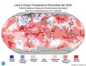 The April 2020 NOAA temperature departure map shows pockets of record warmth on all continents with a marked region of cooler weather over central and northern North America.
- The April 2020 NOAA Global Climate report is out and it appears that the climate continues to get warmer even as the world struggles with the COVID pandemic. In fact, the April 2020 average temperature was 1.91°F (1.06°C) above the 20th Century average and was the second warmest April on record in 141 years–behind only April 2016. Oh and fun, April 2020 was also the 11th warmest month in the past 141 years–all this on the backdrop of a Trump administration which has used the past few months to destroy the environment, such as seizing public lands to drill, mine and timber on, instead of preparing our nation to fight the global pandemic, sad…
- June 3rd is national Egg Day and in honor of this egg-citing holiday, my Google Search of the month was, “Eggs and GIS.” And yep, as you might expect we got a hit but it is not the eggs you might find on your breakfast plate, rather it is a study that incorporates GIS modeling and field studies to look at reproductive rates in Asian carp. Specifically the Iowa State University thesis by Carlos Antonio Camacho incorporates egg drift and density as well as reproductive assessment of Asian carp in tributaries of the upper Mississippi River in Iowa.
- Last month we explored the online GIS resources of South Carolina’s second largest city, Charleston, and for June we head to the Rocky Mountain region with a review of Rapid City, South Dakota’s GIS resources.
Rapid City, SD GIS Website
Rapid City, SD GIS Contacts
Rapid City, SD GIS Web Map
Rapid City, SD GIS Map Collections
Rapid City, SD GIS Direct Downloads (no free downloads though)
Brock Adam McCarty
Map Wizard
(720) 470-7988
brock@apollomapping.com
Low-cost nickel-iron catalyst could bring commercial hydrogen gas production one step close.
Low-cost catalyst improves efficiency of biofuel electrolysis including wood.
Heinz Frei’s synthetic leaf makes significant advancement towards efficiently generating renewable fuels.
Stable perovskite-silicon double-layered solar cell achieves 26.7% efficiency.
Optical fibers coated with a catalyst can produce hydrogen gas from water and sunlight.
New solar cell records set for a tandem setup – (LINK 2) as well as for a six-cell junction variety.
New organic aerogel speeds up desalination and steam generation by absorbing 99% of the Sun’s energy.
Like solar cells this new technology harvests energy by collecting it from metal bonds in compounds.
Low-cost perovskite catalyst improves the conversion of water into hydrogen gas.
New hydrogel could cool batteries plus generate small amounts of electricity.
Low-cost, more environmentally-friendly lithium-sulfur batteries move closer to commercial production.
Significant advance in perovskite solar cell technology moves them closer to replacing silicon cells.
In this monthly feature, we span the globe to examine Our Changing Landscape with a time series of medium-resolution PlanetScope satellite imagery. The PlanetScope constellation dates back to 2016 and collects hundreds of millions of square kilometers of 4 and 5-band 3-meter imagery daily! The COVID-19 focus for recent editions of Our Changing Landscape continues as in April we checked out a major shipping port outside of Shanghai, China, and for the May edition we travel to the United States with a look at one of Amazon’s many truck shipping hubs, i.e. the SAT1 Fulfillment Center, located in Schertz, Texas.
 Click on the image above to see an animation of 3-meter natural color PlanetScope imagery collected over Amazon’s SAT1 Fulfilment Center in Schertz, Texas on December 17, 2019, March 12, March 29, April 13, April 26 and May 10, 2020. In these images, SAT1 can be found right at the center with a large parking lot in the back. In this parking lot, you can see what appears to be a huge upswing in colored shipping containers, which is particularly apparent in the April 26th image. Oh and apologies for some of the less than ideal colors as we had to pick the lowest cloud cover options we could find in evenly spaced time periods! (Images Courtesy: © Planet 2020)
The PlanetScope Microsat Constellation
PlanetScope is a constellation of more than 150 microsats referred to individually as Doves. Each Dove is able to collect up to 20,000 square kilometers (sq km) per day of 3-meter (m) 4-band multispectral (i.e. blue, green, red and near-infrared [NIR]) imagery; and newly launched SuperDoves collect 5-band multispectral adding in valuable red-edge spectral data. Across the constellation, PlanetScope is archiving more than 200 million sq km of medium-resolution imagery a day, making it the go to source for daily imagery over most locations. This massive archive dates back to 2016, offering the most complete and continuous record of spatial data on the planet since the start of the constellation’s ongoing launch schedule. Collecting 3-meter multispectral imagery is the equivalent of ‘high-resolution’ multispectral data imaged by a 75-centimer (cm) satellite (as this satellite would feature 75-cm panchromatic and 3-m multispectral), making PlanetScope an extremely competitively priced option at just $1.80 per sq km. With well registered images and nearly daily collections of most locations, PlanetScope is the ideal imagery source for this current-events focused series, Our Changing Landscape.
Impact on Truck Shipping at Amazon’s SAT1 Fulfillment Center in Texas
In last month’s edition of Our Changing Landscape we detected a significant dip in shipping rates in one of China’s major ports so it piqued our interest to see perhaps the exact opposite affect here in the USA. As many of us are (or were) cooped up at home without the ability to satisfy our consumer hunger in retail stores, we have turned our attention to internet shopping, and particularly to Amazon. While many companies, even ones with a strong internet presence, have seen sales plummet, Amazon has hired more than 175,000 new workers since the COVID-19 outbreak–with some analysts suggesting that could represent a $13 billion+ uptick in sales.
As of late 2019, Amazon was reported to have more than 175 global fulfilment centers with the largest one the massive 1.26-million square foot warehouse, the SAT1 Fulfillment Center, located in Schertz, Texas. Fulfillment centers are used to fill Amazon’s same-day delivery orders, so Schertz central location puts SAT1 within a short drive to San Antonio as it is in its north-east suburbs, or to Austin which is just an hour north, and even to Houston which is about two and a half hours east. With this massive population within a short driving distance, SAT1 is also an excellent focus for this article as Texas put a statewide quarantine in place on March 29th and slowly began lifting them in early May. So it is time to check out the 3-meter PlanetScope archive to see if we can detect an increase in Amazon’s shipping rates during coronavirus days just as we saw in reverse (in China) last month!
If you would like to find out more about using 3-meter PlanetScope imagery for your academic studies, engineering projects or any landscape analysis, let us know at sales@apollomapping.com or (303) 993-3863.
 Despite these grand plans to terraform Mars, it’s a pipedream for the moment with significant hurdles we don’t have the technology to overcome. (Credit: NASA Goddard Space Flight Center)
This is a continuation of my June Out of This World article, so take a gander at it first. While we have one group of researchers turning to genetic engineering to change the face of humanity and send us to the stars, we have another group investigating terraforming. DARPA or the Defense Advanced Research Projects Agency–a wing of the Pentagon–is creating organisms to terraform Mars. It’s not a secret or even surprising that DARPA invests in genetic engineering. I think we’re all aware genetic manipulation is the future of significant progress and terrible destruction.
DARPA is working on a system to quickly engineer a vast array of organisms. E. coli and yeast are commonly used in synthetic biology. Researchers want to harness the expansive genome library to create new organisms by selecting the best genes for a given situation and editing them into novel life forms. They site applications like ending vector-borne illnesses and rehabbing destroyed ecosystems by creating an extremophile organism that can thrive in the aftermath of an environmental disaster. This is a neat idea that could help rebuild our own planet from human devastation. But what about Mars?
 In case you didn’t see the water bear in Out of This World, here it is again. You can’t miss these amazing extremophiles called Tardigrades. It’s too cute. (Credit: ESA/Dr. Ralph O. Schill)
There is this preconceived idea that Mars is a barren wasteland–all red rock, hard earth and unforgiving radiation. What could survive on Mars? Extremophiles, of course. These are the alien creatures researchers are after, not lightbulb-headed aliens with three fingers and green skin. If you’re from an older generation or just a huge Star Trek nerd like myself, think Wrath of Kahn. Dr. Marcus needs a dead planet to study her terraforming machine, Genesis, because it will eradicate the native microbial life. Same theory applies here. Mars is not likely to be entirely dead, especially since it still has seasonal ice flows.
Studies have predicted that extremophiles will long out live humans, even in the face of massive radiation or an asteroid collision making the planet virtually uninhabitable–just like Mars. In this new era of colonization, what are the ethics of destroying native life on another planet to transplant it with our own? Some people won’t care about this. They’ll say the ends justify the means, something humans have said many times before and history has often borne them out as assholes. They’ll say that humans must move on because we’ll never solve our problems at home; we can’t band together as a species to save a planet that already has everything we need to survive. It’s a cute thought, as though moving our species to space will somehow leave our problems behind, that our rivalries will dissipate instead of extrapolate. Fights over territory, technology and ownership are human habits that follow us wherever we go. What I see is a species always outrunning its destruction by our own hands. However, I am comforted by the majestic water bear, knowing that it will survive long after our own destruction gives me hope.
Last month we were in Europe with a look at the site of a canceled international hockey championship, and for the May Pléiades 1–SPOT 6/7 Stadium of the Month we change gears a bit with a visit to the other side of the globe and the site of a scheduled KBO League baseball game, i.e. Jamsil Baseball Stadium, in Seoul, South Korea.

 A 50-cm color image of Jamsil Baseball Stadium in Seoul, South Korea collected on March 31, 2020 by Pléiades 1B; and then a 1.5-m SPOT 6 image of the same stadium collected on April 14, 2020. These images have custom processing and color balancing applied by Apollo Mapping. PLEIADES © CNES 2020, Distribution Airbus DS. SPOT © Airbus DS 2020.
About the Venue: Located in Jamsil-dong (or the silk farming neighborhood) which is south-east of downtown Seoul, Jamsil Baseball Stadium sits along the eastern shore of the Tancheon that drains into the main river, the Han, dividing the town. If you are a regular reader of this series, you know that we do our best to describe the history of the stadium of the month but to be upfront we found little more than you could find already on Wikipedia. We did find this YouTube about some changes to Jamsil Baseball Stadium in 2019; and then this piece on a new design for the Jamsil Sports Complex which contains this venue, but it is unclear what, if any, changes will be made to the stadium.
Fun Factoids: (1) At the time this article was drafted, one if the only professional sport leagues with games scheduled for June is the KBO League. On June 17th, the Doosan Bears who play at Jamsil Baseball Stadium will host the Samsung Lions. Apparently the Bears and Lions are two of the most dominant teams in the KBO; and as of now all KBO games will be played in front of empty seats! (2) Admittedly we have never watched Korean baseball but there are some differences to Major League Baseball (MLB) rules–the biggest being tied games which are declared after 12 innings (or 15 innings in the playoffs), how interesting! (3) Here are some fun moments that have happened during KBO games; and then check out how the 2017 Korean World Series was won.
The Pléiades 1 High-Resolution Satellite Constellation
The Pléiades 1 constellation (or at least part of it!) has been in orbit since December 2011 and if you have not had a chance to check out any sample imagery, take a few moments and have a look at the gallery on our website. If you work with high-resolution imagery, you should consider Pléiades 1 for your next geospatial project.
A variety of Pléiades 1 products are available from both a growing archive and as a new collection, including 50-centimeter (cm) pansharpened imagery and 50-cm panchromatic–2-meter (m) 4-band multispectral bundles. We are happy to discuss the technical specifications, pricing and tasking options available with this satellite constellation.
The SPOT Medium-Resolution Satellite Constellation
The SPOT medium-resolution constellation consist of seven satellites launched from 1986 to 2014 with the most recent additions, SPOT 6 and SPOT 7, launching in 2012 and 2014 respectively. SPOT 6 and SPOT 7 are twin satellites offering 1.5-m panchromatic and 6-m 4-band multispectral data with a massive footprint at 60-kilometers (km) wide. For projects requiring recent archive coverage or rapid new collections of medium-resolution data, SPOT 6/7 should be one of your top imagery sources!
More sample images and technical information about Pléiades 1A and 1B can be found on our website here; while the same can be found here for the SPOT constellation and specifically about SPOT 6/7.
The Apollo Mapping sales team can answer any questions you might have about Pléiades 1 and/or any of the SPOT satellites. We can be reached at (303) 993-3863 or sales@apollomapping.com.
Do you have the need for regularly updated images of locations around the world?
Perhaps you need imagery to integrate with an OEM solution you are developing?
Or maybe your organization uses large amounts of high-resolution imagery each year, and you are seeking a low-cost option for this data?
If you answered yes to any or all of these questions, then the solution you are looking for is Maxar’s SecureWatch (formerly called Global Basemap or GBM).
 As you can see from this map, the SecureWatch +Vivid product offers near complete coverage of the world’s landmasses, pretty impressive!
With SecureWatch, you have access to millions of square kilometers of streamed imagery with low cloud-cover and off-nadir angles. This data is accessible in web-mapping services and in an online viewer. Perhaps the most important feature of SecureWatch are the regular streaming updates you can receive as out-dated imagery is often of little or no use to our valued clients.
And if the SecureWatch streaming database lacks the coverage you need, Premium users are now able to download any image from the entire Maxar archive in a wide variety of formats!
June 2020 Product Update
Last month we checked out the SecureWatch coverage over Africa, and for our June update we pivot to a product that is available with all subscriptions, +Vivid, which are countrywide (or near countrywide) mosaics! If you have not heard of this offering before, the +Vivid coverage is impressive to say the least–check out the coverage map we included with this article. These regional coverage mosaics are also available for offline purchases making them a low-cost solution when GeoTIFF basemaps are required for your mapping project or software application. Here are more specific details on the +Vivid coverage in SecureWatch:
- +Vivid SecureWatch Coverage Statistics
- Total Coverage–132,087,378 square kilometers (sq km)
- Number of Countries Covered–263
- Number of Countries With 100% Coverage–168
- Key Countries With 100% Coverage
- Afghanistan, 641,907 sq km
- Brazil, 8,472,306 sq km
- Germany, 357,200 sq km
- Nigeria, 908,526 sq km
- North Korea, 122,211 sq km
- Sudan, 2,486,947 sq km
SecureWatch Product Specifications
- Accessible Geographic Regions: global (unless geo-fencing specifically requested by client)
- Maximum Imagery Resolution: 50-centimeters through WMS and WCS; 30-cm for other delivery mechanisms
- Data Sources: primary = WorldView-2/3/4 and GeoEye-1; secondary = QuickBird, IKONOS, WorldView-1 and aerial
- Imagery Holdback Period For Updates: 90 day holdback for SecureWatch Standard; 2 day holdback for SecureWatch Premium; updates are to limited portions of the database, not the entire database
- Data Accuracy: at least 8.5-meter CE90%
- Database Access: OGC streaming services (i.e. WMS, WMST, WCS and WFS), Google Earth streaming services (i.e. EarthService), ArcGIS plugin (i.e. ImageConnect), offline database/downloads and online portal
- Annual Downloads & Streaming Limits: Standard = 4 gigabytes (GB) and up, annual license for downloads; Premium = 2 GB and up, perpetual license for downloads
- Maximum Concurrent Users: unlimited!
- Data Layers: Standard = standard image strips, +Vivid country-wide mosaics, and OSM and Google Maps vectors; Premium = standard, +Daily and First Look image strips, +Metro, +Vivid and Landsat mosaics, and OSM and Google Maps vectors
- Pricing Model: Standard and Premium tiered annual pricing models with increasing download and streaming limits; also a Streaming only annual model based on seats
SecureWatch Direct Archive Download Specifications
Premium SecureWatch users are able to download high-resolution satellite imagery from the entire Maxar archive in a variety of formats. Here are some details on this exciting offering:
- Available Data Sources: entire commercial archives of GeoEye-1, IKONOS, QuickBird and WorldView-1/2/3/4 (SWIR included too!)
- Annual Downloads Limits: 2 GB and up; metering combined with streaming usage
- Product License: internal use and perpetual
- Product Resolution: maximum resolution for each satellite
- Product Formats: all standard types are offered including, orthoready, stereo, basic, 4-band bundle, 8-band bundle, ACOMP on, etc.
For more information on the pricing and coverage available in Maxar’s SecureWatch, you can reach our sales team anytime at sales@apollomapping.com or during typical American business hours at (303) 993-3863.
If you are searching for medium and high-resolution satellite imagery, the search is over as Image Hunter is the solution you’ve been looking for! Featuring satellite and aerial imagery as well as digital elevation models (DEMs) from a constantly expanding list of 48 sensors/datasets and 17 vendors, our database contains more than 100-million images/records meaning there is just no other website out there with this breadth of commercial data products. Our interface is slim-lined and modern, loading quickly on all platforms, browsers and operating systems. Further, our database is updated multiple times an hour with the most recent images collected by Maxar-DigitalGlobe, Airbus, Planet and more so you are sure to get the most current view of all the imagery and DEM databases we work with. Once you submit your request, an Apollo Mapping representative will be in touch within 4 Colorado business hours to get you the pricing information you need for your project.

So why wait? Give Image Hunter a try now to find the imagery and/or DEM data you need for your next mapping project!
Key June 2020 Improvement(s)
Sometimes system maintenance is our focus and well it certainly was this past month! Specifically we focused on fixing up a few updates which are mission critical as they ultimately feed data into Image Hunter as well as some digital elevation model resolutions. Our one customer facing change for the month is a pretty neat one, its drag and drop file uploads, woot woot (good idea Katie)!
Here is a summary of the changes/improvements we made to Image Hunter in the past month:
- Added Drag and Drop uploads for shapefiles, KMZs and GeoJSONs.
- Changed out the API we use for Airbus updates.
- Fixed a bug with querying PlanetScope images.
- Updated the resolution of Hexagon digital surface models (DSMs) and point clouds
Data Alert–An Automated Daily Imagery Search
Have you checked out Data Alert which lets you define an area of interest anywhere around the globe, the resolution your project requires and the number of months we should keep the alert active? Once an alert is set up, we check for new data over your area of interest every single day, and send you an email when we find coverage that meets your specifications. We have a short YouTube video with directions to set up a Data Alert, check out the last video; and we have written directions for Data Alert here.
The Sensors Available in Image Hunter
As you might have seen in past articles, we now feature hourly updates (seriously!) of GaoFen 1/2, GeoEye-1, KOMPSAT 2/3/3A, Pléiades 1, SPOT 6/7, SuperView-1, TripleSAT, WorldView-1/2/3/4 and ZiYuan-3!
Image Hunter can be accessed 24 hours a day, 7 days a week and is a one-stop shop for every major source of medium and high-resolution satellite (and aerial!) imagery on the market today, including:
- WorldView-4
- WorldView-3
- WorldView-2
- WorldView-1
- QuickBird
- GeoEye-1
- IKONOS
- EROS B
- KOMPSAT-3A
- KOMPSAT-3
- KOMPSAT-2
- Pléiades 1 constellation
- Deimos-1
- Deimos-2
- TripleSat
- SPOT 1 to 7 constellation
- RapidEye
- GaoFen-2
- GaoFen-1
- ZiYuan-3 01/02 (mono and stereo!)
- FORMOSAT-5
- FORMOSAT-2
- ALOS PRISM (stereo)
- AW3D Standard (DEM)
- SkySat constellation
- PlanetScope constellation (including 5-band SuperDove data)
- SuperView-1 constellation
- Landsat 1-8
- TeLEOS-1
- Hexagon (HxGN Content Program aerial imagery)
- WorldDEM
- Vricon DEMs
- Orbita Hyperspectral Satellite (OHS)
- KazEOSat-1
- KazEOSat-2
Key Features of Image Hunter
If any of our readers have struggled with other geospatial search engines that are clunky, only query one data source and/or do not provide image previews, then Image Hunter is the solution to your woes as it features:
- Online browsing of satellite and aerial imagery from 15 data providers and 44 satellite and aerial imagery derived datasets.
- Near-instantaneous loading of low-resolution preview imagery with collection date, cloud cover and other key metadata.
- The ability to define your area of interest by address, coordinates, geometric shape or shapefile/KMZ.
- A responsive basemap with street names to provide spatial context when discovering data as well as crowd-sourced updates for the most accurate map possible.
- Exports of the area of interest you create as well as the scenes you select in shapefile or KMZ format.
- Support for all operating systems, and not just our friends with Windows machines!
Image Hunter can be accessed here all day and night, we are excited to find out what you think about our imagery search engine! So if you have any ideas and/or feedback to improve Image Hunter, please let us know at sales@apollomapping.com or (303) 993-3863.