
Summer is here! When I was a kid, summer meant being outside, almost all day. Bike riding to create a breeze, dancing through the sprinkler on a hot afternoon, flagging down the ice cream truck for a popsicle, slurping watermelon fresh from the fields, skiing on the lake, catching fireflies at dusk, and on some lucky occasions… a trip to the beach. We didn’t care about what we wore or how we looked (or smelled). It was all about…fun.
In this column, we have talked about various enriching activities and good habits to improve our wellness. With summer here, fun feels like it should be on the menu. Perhaps we need an adult recess period. How do we make that work?
 B. Duke created in Canva.
Playtime is incredibly good for you at any age. It boosts brain function, improves mental health by reducing stress and releasing endorphins, and strengthens relationships through shared connection. Playing with your dog is the ultimate bonding experience! It releases oxytocin, provides necessary physical and mental stimulation, and improves obedience. The best approach involves clear rules, safe games, and active participation.
In February, we talked about the long-standing relationship between dogs and humans. In a recent Technology.org article, the fun and bond we need might be with your dog. There’s factual evidence that playing with your dog is not only good for you but also creates a stronger bond. “The results showed a statistically significant causal relationship where the emotional bond to the dog is improved by increasing the time of play.” Karen Pryor Academy agrees with the importance of play as a vital part of the emotional health of your dog. Canine Revolution Training has some excellent recommendations to make sure the play is fun and within some good boundaries.
Dogs aren’t the only ones that need to play to develop more effectively. For children, play is the primary way they learn, build physical coordination, and develop social skills like sharing and negotiating. The Starlight Children’s Foundation shared the value of play for kids in hospitals. Brown Health recommends “some ideas for parents to set the groundwork for creative play:
- Gather a bunch of objects that could combine to make an obstacle course and let the kids take it from there.
- Take kids to a local park with woods and let them make a fort out of sticks. Being surrounded by nature and hearing the forest can be both soothing and stimulating.
- Take children to a shoreline and go “treasure hunting” for shells and interesting rocks. Create a fun collage with the items found.
- Provide minimal props like chalk and a chalkboard to encourage school age children to pretend play “school,” with one child being the teacher and others being the school children.
- Provide paints and paper, clay, or beads and allow your children to create from their imagination.”
Since 2024, the United Nations General Assembly adopted June 11th as the International Day of Play. Their site says, “Global research surveying more than 25,000 children across 36 countries reveals that as many as 73% of children don’t believe adults take play – and how it can help them learn – seriously.” The Right to Play initiative has program information, research, and ideas to help integrate more play in your life.
Perhaps all the outdoor playing and pretending that we did as kids was more valuable than we knew. Imaginary school, cooking up “pies” from mud, and “treasure hunting” in the woods was a foundation that none of us knew we needed. If you have a kid and a pet, that seems to be a bonus for the fun factor, but don’t let that hold you back if not. I hope you’ll have some fun this summer.
If you need me, I’ll be on the porch enjoying a popsicle or watching fireworks from the bed of a pickup truck. Have some fun!
Barbaree Duke
Geospatial Crusader
¡Bienvenidos a junio! Nosotros en Apollo Mapping estamos gustosos de tenerlos otro mes aquí en los resúmenes españoles del mes de junio.
PRODUCTO DESTACADO – La Constelación SuperView Neo – Resolución de 25 cm + Un Archivo Masivo
 Una muestra en color de 25 cm de SuperView Neo-1 recopilada sobre Al Ain en los Emiratos Árabes Unidos el 3 de agosto de 2025.
¿Has escuchado sobre la constelación SuperView Neo? ¡Si no es así, es momento de conocerla mejor! Primero están los SuperView Neo-3 01/02 de 50 centímetros (cm) y 8 bandas, dos satélites gemelos ambos con huellas de imagen masivas. Y luego están los SuperView Neo-1 03/04, dos satélites que presentan nuestras primeras imágenes de 25 cm y 4 bandas con bandas azul, verde, rojo e infrarrojo cercano (NIR). Completando la constelación están los SuperView Neo-1 01/02, ambos con resolución de 30 cm e imágenes de 4 bandas. Entre los seis satélites SuperView Neo activos, la constelación acumula aproximadamente 5.8 millones de kilómetros cuadrados de imágenes de alta resolución cada día, ¡impresionante!
Si deseas obtener más información sobre la constelación SuperView Neo, consulta nuestra página web dedicada aquí.
Y si deseas consultar imágenes satelitales de SuperView Neo-1 y SuperView Neo-3 en cualquier momento, puedes hacerlo en Cazador de Imágenes ahora.
También puedes enviarnos un correo electrónico con preguntas o solicitudes de precios específicos para la constelación SuperView Neo a sales@apollomapping.com.
Producto Destacado – Descuentos para Organizaciones Sin Fines de Lucro en Imágenes de Archivo de Vantor
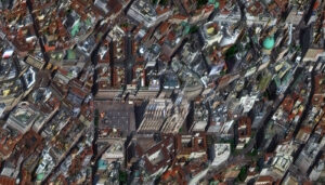 Una imagen de 79 centímetros de alto ángulo fuera de nadir recopilada sobre las Terrazas del Duomo en Milán, Italia el 9 de abril de 2019 por el WorldView-3 de Vantor.
Bien, esto no es tanto un producto como lo es, bueno, ¡un descuento; y a quién no le gusta un descuento?! Y ese descuento es un 30% de descuento exclusivo de la industria en todos los productos de imágenes de archivo de Vantor para organizaciones sin fines de lucro (también llamadas ONGs)!
Si formas parte de una organización sin fines de lucro con un proyecto que requiere imágenes de archivo de Vantor con descuento, ¡haznos saber y estaremos encantados de ayudarte a completar una búsqueda en el archivo! Solo envíanos los detalles de tu proyecto y el polígono de orden a sales@apollomapping.com y te responderemos de inmediato. También puedes consultar todo el archivo de imágenes de Vantor en cualquier momento usando Cazador de Imágenes.
Por favor, ten en cuenta que este descuento no aplica a los productos Vantor Vivid, modelos digitales de elevación (DEMs) ni a órdenes de captura de imágenes.
La Vista a Vuelo de Pájaro – Milán, Italia

 Este mes presentamos dos pintorescas imágenes de Milán, Italia recopiladas por WorldView-3 el 9 de abril de 2019. En estas imágenes de aproximadamente 79 centímetros, presentamos las Terrazas del Duomo en la primera imagen y luego el Civico Planetario Ulrico Hoepli, ¡godere! (Imágenes Satelitales © 2026 Vantor)
¡Cada mes, presentaremos una nueva imagen satelital a vuelo de pájaro desde un lugar selecto alrededor del mundo; y este mes, nos dirigimos al lugar de los recientes Juegos Olímpicos de Invierno 2026, Milán, Italia!
¿Qué es la Imagen Satelital a Vuelo de Pájaro?
¡Buena pregunta, y con gusto la respondemos! Cuando un satélite capta imágenes del suelo debajo de él, siempre hay una cierta inclinación en la cámara al mirar hacia abajo. Esta inclinación se denomina fuera de nadir y se mide en grados desde 0; por lo tanto, 0° fuera de nadir significa que el satélite apunta directamente hacia el suelo al capturar imágenes, mientras que 90° fuera de nadir significaría que el satélite apunta hacia un lado y ni siquiera al suelo debajo de él al capturar imágenes. La gran mayoría de las imágenes satelitales se recopilan con un ángulo fuera de nadir inferior a 30°. Sin embargo, en ocasiones raras, ya sea por solicitud de un cliente o para capturar un desastre natural u otro evento importante, un satélite puede inclinarse e imágenes en el rango de 35° a 50°, lo que consideramos ideal para imágenes de alto ángulo fuera de nadir, también llamadas imágenes a vuelo de pájaro e imágenes oblicuas. Estas imágenes a vuelo de pájaro ofrecen una perspectiva única de las imágenes satelitales, con una vista amplia del paisaje desde el lado. Esperamos que disfrutes las imágenes satelitales a vuelo de pájaro que compartimos en este artículo. Y si tienes alguna pregunta sobre este tipo de datos o cualquiera de los productos de imágenes con los que podemos ayudarte, ¡envíanos un correo electrónico en cualquier momento a sales@apollomapping.com!
Si estás interesado en imágenes satelitales adicionales a vuelo de pájaro desde esta ubicación, dirígete a nuestro subgrupo de Reddit, VistaVueloDePájaro, y conviértete en miembro. Publicamos imágenes satelitales de alto ángulo fuera de nadir todos los viernes en el subgrupo VistaVueloDePájaro.
Fernando Gutierrez
Topographic Translator
We love maps.
We love imagery.
We love work breaks.
We hope you like them as well!
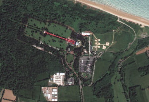
Historic D-Day unfolded on June 6, 1944, and altered the course of World War II. Along the coastline of Normandy, France, where the legendary D-Day beach landings took place, is where more than 4,000 American soldiers died.
The Normandy American Cemetery is where we can find the graves of nearly 9,400 soldiers in total who lost their lives during that war. Almost 1,600 names are etched on the walls in the nearby Garden of the Missing. The cemetery sits on a bluff high above the coast where three Medal of Honor recipients were laid to rest and 45 sets of brother were buried side by side.
To commemorate the 80th anniversary of D-Day on June 6, 2024 – a day now known as the greatest amphibious landing in history – former President Joe Biden and French President Emmanuel Macron led a ceremony that was attended by thousands, including WWII veterans. The event featured speeches about democracy, military flyovers, and emotional tributes. Macron awarded the Legion of Honor to 11 U.S. WWII veterans during the ceremony. The ceremony included a wreath-laying, a 21-gun salute, and the playing of Taps.
Every year, more than a million people visit the historic cemetery to pay their respects to the fallen. At the west end of the cemetery, granite statues represent the United States and France. A small chapel sits at the center of the cemetery. Inside, a ceiling mosaic depicts America blessing her sons as they depart to fight for freedom. In the open arc of the memorial, a bronze statue symbolizes the indomitable spirit of American youth. The 17-acre site of the cemetery was filled with people wanting to pay their respects and recognize those who gave their lives in an historic event.
For this month’s Imagery Work Break, we feature a 40-centimeter GeoEye-1 color enhanced photo from June 6, 2024. In the image, you can see the long red stretch of carpet laid down for the 80th anniversary at the cemetery. The ocean rolls up on the beach nearby, while the cemetery can be seen surrounded by lush vegetation.
Have a great rest of your workday! 😊
(Image Courtesy: Vantor. Processed by Apollo Mapping for improved grey-scale accuracy and clarity.)
I often wonder if I ever really know what I “want.” I go about life as if I do in all matter of things, but the adage, “be careful what you wish for, it may just come true” seems to follow me around, too. I also have a very self-destructive streak in me that I haven’t been able to shake since grade school, so that doesn’t help things at all. For me, I get these dreamy visions in my head of desires and possibilities, and more often than not, they don’t come to fruition (e.g., becoming an amazing drummer, or traveling around the country climbing all the best routes). Mostly, I strike this up to laziness – some things just take too much effort (or money), and/or the learning curve is too long. Sadly, many of us don’t start things (or see them through) because we’re put off by the chase for accomplishment and competency when we should instead be with trying to enjoy whatever we can make of it.
Previously, I’d mentioned this gal I’ve been dating, going on five months now, and by and large, it’s going very well. Nonetheless, on occasion, I’ll find myself questioning if I really want to get tangled up in a serious relationship – not because of anything specific about her per se, but simply because I’ve gotten used to flying solo and coupling up when it’s convenient for me for short-term affairs only. But even as I allow these thoughts to drift into my head, I realize that I’m foolishly questioning a good thing. Relationships come with compromise and require a willingness to check one’s ego, something that doesn’t come naturally to me, though.
 Sometimes I overthink things and it’s not to my advantage. (Image comes courtesy of cottonbro studio and was retrieved from here.)
On a few occasions I’ve found myself jumping the gun to get frustrated about, admittedly, ticky-tacky nonsense from her/between us – none of which was directed at me, mind you, yet I still interpret the comments/actions as an indictment of me in some petty way. When I allow myself to think about these circumstances rationally, I realized how foolish they are. I also think/know that everyone is allowed to have a bad day/be off their game/overstep from time-to-time, and approaching those you love with appreciation and grace in these matters (or all matters, really) is the best course of action. But I’m stubborn and can be quite judgmental, delivering verdicts quickly and without consideration.
Several years ago, I came up with a “mantra” of sorts, sloppily handwritten on a piece of paper and clipped to the bottom of my calendar next to the door I come and go from several times a day. It reads, “Life will be more enjoyable if I assume good intent from others; if I only observe and not judge others; and if I slow down and be more patient.” I firmly believe these all to be true. I also fail at all of them almost daily. But I try to do better. It’s often a slow and aggravating process. And most importantly, I’m trying to have this be my default setting with the gal I’ve been dating – and I think I’ve mostly done well in this regard, but there have been a few slip-ups along the way. Such is life.
But my point isn’t really about her at all – it’s about me and how I seemingly never know what I really want or if I truly want anything at all. I have indulgences, but it seems most things I desire for I lose interest in eventually. This could be a bicycle, a shirt, a place, a band, but mostly it’s rooted in this protective shell I’ve built around myself and my attempts at keeping my life as predictable and on my schedule as possible – so, usually, it’s about people. You see, I love routines, and while that has greatly enhanced my life in many ways, I don’t doubt my rigid adherence to them has disrupted it greatly, too. It’s a bit of a Catch-22. Sometimes relationships suffer. I’m trying to not make this be the case here.
At this point, I have no doubt that you’re wondering whether I’m wavering about this gal and our potential future together – not at all, honestly. Even as I allow my mind to wander into those dark crevasses where I question what and who is worth it or not, at least so far with her, I’ve crawled out of them, and fairly quickly. I imagine I’ve just gotten so used to things on my terms all the time that I’m just recalibrating. That’s probably a good thing, but I wish it would go a little more smoothly at times.
I remember several decades ago I briefly dated this gal named Dana – on paper, and in real life, she was everything a guy could hope for, but I sabotaged it pretty swiftly. I recall asking myself late one night as she lay asleep beside me, “Is the pain of the love I’ll lose one day worth the joy I have now?” I answered “no,” and the end soon came. But why did I even ask such a question in the first place?
I’m considering that question again with a different gal and I hope I make a better choice this time around. But I go back to one of the earliest things I said to her and that I titled a recent entry: Hope & Possibility. I’ve found if/when I reorient back to that I sort out my moorings and bearings pretty quickly and that’s when I most realize how lucky I am and how I should try not to mess this up. I hope she expends equal effort for the same goal. ☺
Marco Esquandoles
My Own Worst Enemy
Each month, we’ll feature a new bird’s eye view satellite image from a select location around the globe; and for this month, we head to the site of the recent 2026 Winter Olympics, Milan, Italy!
What Is Bird’s Eye View Satellite Imagery?
This month we feature to picturesque images of Milan, Italy collected by WorldView-3 on April 9, 2019. In these about 79-centimeter images, we feature Duomo Terraces in the first image and then Civico Planetario Ulrico Hoepli, godere! (Satellite Imagery © 2026 Vantor)Well, that’s a good question we are happy to answer! When a satellite images the ground below it, there’s always some tilt to the camera as it looks down. This tilt is called off-nadir and is measured in degrees from 0; and so, it follows that 0° off-nadir means that the satellite is pointing directly down at the ground when it images, while a 90° off-nadir would mean that the satellite is pointing to the side and not even at the ground below it when it images. The vast majority of satellite imagery is collected with an off-nadir below 30°. However, in rare occasions, be it by a customer request, or to capture a natural disaster or other important event, a satellite can tilt and image in the range of 35° to 50° which we consider ideal for a high off-nadir imagery, also called bird’s eye view imagery and oblique imagery. These bird’s eye view images lend a unique perspective to satellite imagery that is an expansive view of the landscape from the side. We hope you enjoy the bird’s eye view satellite imagery that we share in this article. And if you have any questions about this type of data or any of the imagery products we can help you with, send us an email at any time to sales@apollomapping.com!
If you are interested in additional bird’s eye view satellite images from this location, head over to our Reddit subgroup, BirdsEyeViewImagery, and become a member. We post high off-nadir satellite imagery every Friday in the BirdsEyeViewImagery subgroup.
A 79-centimeter high-off nadir image collected over Duomo Terraces in Milan, Italy on April 9, 2019 by Vantor’s WorldView-3.Okay so this not so much a product as it is, well, a discount; and who doesn’t like a discount?! And that discount is an industry-exclusive 30% discount on all Vantor imagery products from the archive for non-profit organizations (also called NGOs)!
If you are part of a non-profit organization with a project that requires discounted Vantor imagery, let us know and we would be happy to help complete an archive search. Just send us your project details and order polygon to sales@apollomapping.com and we will get right back to you. You can also query the entire Vantor imagery archive at any time using Image Hunter.
Please note that this discount does not apply to Vantor Vivid products, digital elevation models (DEMs) or imagery tasking orders.
If you are searching for medium and high-resolution satellite imagery, the search is over as Image Hunter is the solution you’ve been looking for! Featuring satellite and aerial imagery as well as digital elevation models (DEMs) from a constantly expanding list of 70+ constellations/datasetsand19 vendors, our database contains more than 500-million images/records meaning there is just no other website out there with this breadth of commercial data products. Our interface is slim-lined and modern, loading quickly on all platforms, browsers and operating systems. Further, our database is updated multiple times an hour with the most recent images collected by WorldView-3, Pléiades 1, PlanetScope, SuperView Neo and many more so you are sure to get the most current view of all the imagery and DEM databases we work with. Once you submit your request, an Apollo Mapping representative will be in touch within 4 Illinois business hours to get you the pricing information you need for your project.
So why wait? Give Image Hunter a try now to find the imagery and/or DEM data you need for your next mapping project!
Key Improvement(s) From The Past Month
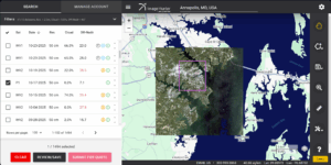
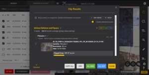
Our new Clip Polygon To Image tool is live! Give it a try to automatically calculate the coverage areas of a complex set of imagery from various data vendors and satellite constellations.
Now that our Clip Image to Polygon tool is live, we have been busy working on the backend to streamline the overlap reduction process as well as fixing a few bugs. We hope you are as excited about the new tool as we are; and if you haven’t given it a try, head over to Image Hunter now and give it a test!
Here is a summary of the changes/improvements we made to Image Hunter during the past month:
- Version 3 of the Clip Image to Polygon tool is now live with a series of bug fixes, improved area labeling and a more streamlined GUI.
- Improved backend updates for a few satellite constellations.
- Fixed a small bug in the image search results section.
- Added a Legacy label for imagery datasets without previews and/or ordering support; and removed these Legacy datasets from the default query.
- A few satellites reported false positives when polygons were close to an image ID’s edge – now they don’t.
Data Alert – An Automated Daily Imagery Search
Have you checked out Data Alert which lets you define an area of interest anywhere around the globe, the resolution your project requires and the number of months we should keep the alert active? Once an alert is set up, we check for new data over your area of interest every single day, and send you an email when we find coverage that meets your specifications. We have a short YouTube video with directions to set up a Data Alert, check out the last video; and we have written directions for Data Alert here.
The Sensors Available in Image Hunter
As you might have seen in past articles, we now feature hourly updates (seriously!) of GeoEye-1, KOMPSAT 3/3A, Pléiades 1 and Neo, SPOT 6/7, SuperView-1/2/Neo, WorldView-1/2/3/Legion!
Image Hunter can be accessed 24 hours a day, 7 days a week and is a one-stop shop for every major source of medium and high-resolution satellite (and aerial!) imagery on the market today, including:
- WorldView Legion
- WorldView-4
- WorldView-3
- WorldView-2
- WorldView-1
- QuickBird
- GeoEye-1
- IKONOS
- EROS B
- KOMPSAT-3A
- KOMPSAT-3
- KOMPSAT-2
- Pléiades 1 constellation
- Pléiades Neo constellation
- TerraSAR-X (TerraSAR-X, TanDEM-X and PAZ)
- GEOSAT-1
- GEOSAT-2
- TripleSat
- BJ3A
- BJ3N
- SPOT 1 to 7 constellation
- RapidEye
- GaoFen-2
- GaoFen-1
- ZiYuan-3 01/02 (mono and stereo!)
- FORMOSAT-5
- FORMOSAT-2
- ALOS PRISM (stereo)
- AW3D Standard (DEM)
- SkySat constellation
- PlanetScope constellation (including 5-band SuperDove data)
- SuperView-1 constellation
- SuperView-2
- SuperView Neo-1 01/02/03/04
- SuperView Neo-3 01/02
- Landsat 1-8
- TeLEOS-1
- DS-EO
- Hexagon (HxGN Content Program aerial imagery) imagery + DEM
- WorldDEM
- WorldDEM Neo
- Vricon DEMs
- Orbita Hyperspectral Satellite (OHS)
- KazEOSat-1
- KazEOSat-2
- Jilin-1 Optical
- Jilin-1 Video (including nighttime imagery)
- Jilin-1 GF/DP
- Jillin-1 KF
- Orbita Video Satellites-1/2/3 (OVS-1/2/3)
- BlackSky Global series
Key Features of Image Hunter
If any of our readers have struggled with other geospatial search engines that are clunky, only query one data source and/or do not provide image previews, then Image Hunter is the solution to your woes as it features:
- Online browsing of satellite and aerial imagery from 19 data providers and 56 satellite and aerial imagery derived datasets.
- Near-instantaneous loading of low-resolution preview imagery with collection date, cloud cover and other key metadata.
- The ability to define your area of interest by address, coordinates, geometric shape or shapefile/KMZ.
- A responsive basemap with street names to provide spatial context when discovering data as well as crowd-sourced updates for the most accurate map possible.
- Exports of the area of interest you create as well as the scenes you select in shapefile or KMZ format.
- Support for all operating systems, and not just our friends with Windows machines!
Image Hunter can be accessed here all day and night, we are excited to find out what you think about our imagery search engine! So if you have any ideas and/or feedback to improve Image Hunter, please let us know at sales@apollomapping.com or (303) 993-3863.

Cricket’s Chirp is created for Apollo Mapping by Ron Ruelle, a Northwest Ohio (formerly Boulder, CO) based cartoonist, lllustrator and teacher. No animals are harmed in the creation of these comics, but Ron sometimes breaks a pencil in frustration. He has a new collection of his weekly Skelton Comics available at www.ronruelle.com