
- Oh technology, how do I love thee! It’s time again for my favorite snippet of the month, so without delay here we go with our technology review!
Biofuel: This new genetically-engineered algal strain produces up to twice the amount of biofuel as in the past; and this low-cost catalyst made from sand speeds up algal production of biofuels. Here is research to extract catalysts for biofuel production from used aluminum foil.Solar: A South Korean solar company is set to build the world’s largest floating (and rotating) solar farm; while an Australian company is planning on printing combined solar panels and solid-state storage batteries. This new solar panel design captures energy from nearly the entire light spectrum; and this design uses bismuth to create a non-toxic panel. And how about this 16-year old kid who convinced a city to require solar panels on all new homes – nice work Delaney!
Random: This self-contained filter works like a jungle to purify water. Heavy metals are hard to clean up when spilled into the environment but this genetically-engineered yeast can absorb up to 80% of these contaminants. This nanomaterial could be the solution to storing renewable energy at a low-cost. Removing carbon dioxide from the air could help mitigate the impacts of Climate Change and this enzyme could supercharge carbon sequestration by up to 500 times.
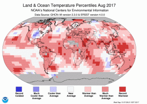 The August 2017 temperature departure map shows pockets of record warmth across all continents other than Australia with a marked pocket of cool weather over the central USA and northern Russia.
- The August 2017 NOAA global climate report is out it confirms that this past August was the 3rd warmest on record behind 2016 and 2015 only. It was also the 41st consecutive August above the 20th Century temperature average and the 392nd consecutive month above the same average. But you know, climate change is not real, and in Florida if you are a government official you are not even allowed to use the words, climate change; wonder how they will chat about Hurricane Irma then?
-
- October is here so that means Halloween is just around the corner, and in honor of this “important” holiday, my Google search of the month was, “GIS and witch.” If you look through the results, you might find this interactive paper/GIS created by Benjamin Ray of the University of Virginia of the 1692 Salem witch trials. And while it does not look like the work was ever finished, there is a good handling of common issues GIS, such as mis-registration and digitization.
- Last month we were in Dover, Delaware with a review of their online GIS resources and this month we move to Miami, Florida’s second largest city, with a review of their GIS resources. And while the Miami-Dade County GIS website is quite robust, the City of Miami’s GIS site leaves much to the imagination. On this simple, single-page website, there is no contact information but there is a link to robust webmap which is fast, features a variety of layers and lets users query easily. There is no apparent way to download the layers behind the webmap.
Brock Adam McCarty
Map Wizard
(720) 470-7988
brock@apollomapping.com

Leave a Reply