
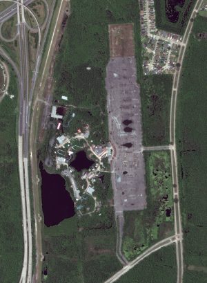
 This month’s 30-cm WorldView-3 image features Jazzland – Six Flags in New Orleans, Louisiana. While Jazzland opened in 2000, Six Flags took over just three years later in 2002 changing the name to Six Flag New Orleans. But after Hurricane Katrina inflicted damage on the area, not all of the floodwaters receded and what was left caused saltwater damage to the rides and buildings. Eerie, like the set of a scary movie, best describes this image of the abandoned Six Flags New Orleans. The largest rollercoaster winds in and out of the overgrown patch of trees, while the smallest rollercoaster can barely be seen above the tops of the trees. The buildings are run down, resembling an abandoned ghost town. A body of goopy water left over from Hurricane Katrina drowns out many areas of the park and the Ferris wheel nearby appears to be leaning after enduring the high winds of a hurricane. Even the parking lot has the distinct feel of being long neglected with its dark patches, cracks and other signs of wear and tear. New Orleans Police have battled vandalism and graffiti at the abandoned amusement park, but numerous movies have filmed at the creepy property including Killer Joe, Stolen, Percy Jackson: Sea of Monster, Dawn of the Planet of the Apes and Jurassic World. A rapper even used parts of the park in a music video. The 30-cm WorldView-3 image of Six Flags New Orleans was captured April 21, 2021. This 30-cm WorldView-3 image has been processed by Apollo Mapping for improved perspective, clarity and colors. (Satellite Imagery © 2024 Maxar Technologies)
Every time we look at WorldView-3 and WorldView-4 (WV3/4) imagery, we are blown away. And we hope you are equally impressed with the data! In February, we checked out a football (soccer) field surrounded by historic buildings in Imotski, Croatia. For this edition of the 30-cm Color WorldView-3/4 Image of the Month, we gaze in disbelief at the abandoned Six Flags amusement park in New Orleans.
WorldView-3 launched in late 2014 and WorldView-4 launched in late 2016; taken together they are the most advanced satellite constellation the commercial marketplace has ever had access to. Here are a few of the features that really set these satellites apart from the competition:
- Improved Resolution
- Higher resolution means you can see more detail in WV3/4 imagery.
- Data collected at nadir will have 31-centimeter (cm) panchromatic, 1.24-meter (m) visible and near infrared, 3.7-m SWIR (WV3 only) and 30-m CAVIS (WV3 only) bands.
- At 20 degrees off-nadir, the resolution is 34-cm panchromatic, 1.38-m visible and near infrared and 4.1-m shortwave infrared.
- Additional Spectral Bands
- If spectral analysis is part of your project, then no other satellite can match WV3 with its: 8 bands of visible and near-infrared data; and 8 shortwave infrared bands which are crucial for geological studies.
- Better Positional Accuracy
- With accuracies of 3.5-m CE90% or better (without ground control even!), WV3/4 has no rivals for its enhanced positional accuracy.
- Daily Revisits
- At 40 degrees latitude, WV3 is able to image every location daily with 1-meter or better resolution and then every 4.5 days at 34-cm resolution or better.
- WV4 is no longer collecting new imagery.
- At 40 degrees latitude, WV3 is able to image every location daily with 1-meter or better resolution and then every 4.5 days at 34-cm resolution or better.
- Increased Collection Capacity
- WV3/4 feature 13.1-km swath widths (at nadir) with the ability to collect up to 680,000 square kilometer (sq km) of high-resolution data per day per satellite (though WV4 is dead now).
- Improved control movement gyros translate into larger maximum contiguous collection areas per pass, with up to ~7,500 sq km of mono imagery and ~3,000 sq km of stereo possible.
If you are interested in WorldView-3 and/or WorldView-4 imagery for your next project, please let us know by phone, 303-993-3863, or by email, sales@apollomapping.com.
You can also find more WV3 samples and technical information on our website here and then WV4 samples and information can be found here.

Leave a Reply