
We love maps.
We love imagery.
We love work breaks.
We hope you like them as well!
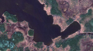
In many parts of the United States, November means snowfall and for outdoor enthusiasts, that means ice fishing. Lac Tantouin in Quebec, Canada, a fairly remote body of water, is located in Cote-Nord County and province of Quebec, in the eastern party of the country, east of Ottawa.
Lac Tantouin happens to be a popular lake among anglers, who revel in the peacefulness of its setting as it’s surrounded by forests and mountains. The lake sits 507 meters above sea level, spans 1.8 square kilometers and is irregularly shaped. The average depth of the lake is 626 meters, with a maximum depth of 2,500 meters. But it’s a bit brisk there with the warmest month being July where the temps still only reach the low 50s and the typically coldest month – December – drops to an average of -4 degrees Fahrenheit.
Surprisingly, Lac Tantouin is so remote and a best kept secret among anglers that there are no reports of common fish species there. Any of our readers care to share what fish they’ve caught there or have heard about in this gem of a lake?
For this month’s Imagery Work Break, we feature a 50-cm color GeoEye-1 image from October 24, 2021. You can see the lake’s curvy banks and deep rich water, beckoning people to fish, kayak or swim – when the weather is a bit warmer, of course.
Have a great rest of your workday! 😊
(Image Courtesy: Maxar. Processed by Apollo Mapping for improved color accuracy and clarity.)

Leave a Reply