
Apollo Mapping is excited to announce that for the first time ever, we can now offer nighttime high-resolution satellite imagery collected over any location on the planet. Partnering with ImageSat International, owners and operators of EROS A and EROS B, we are now able to provide you with custom collections of ~70-cm panchromatic imagery over areas as small as 50 square kilometers. As an added bonus, the price for this nighttime imagery is still below what you would pay for the minimum collection of color, high-resolution, daytime imagery.
 A chart showing times of the year (with respect to latitude) that nighttime imaging is possible with EROS B.
We have tasked EROS B on multiple occasions and have been impressed with the turnaround time and high-quality panchromatic imagery it can deliver. While many people shy away from black and white only data, when it comes to nighttime imagery, there is little to no difference between black and white and color data. Further, by collecting only panchromatic data, EROS B can maximize collection capacity so you receive tasked imagery quicker.
Key Specifications of EROS B
- Launch Date – April 25, 2006
- Spectral Bands – panchromatic only
- Resolution – 70 centimeter (varies with orbital height, off-nadir angle and imaging mode)
- Revisit Time – ~3.5 days (varies with latitude and off-nadir angle)
- Swath Width – 7 km (varies with orbital height and off-nadir angle)
- Bit Depth – 10-bits
- Orbit Height – 520 km (varies about this average)
For more information on this new nighttime, high-resolution tasking service, please contact the Apollo Mapping sales team at (303) 993-3863 or sales@apollomapping.com.
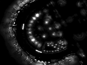
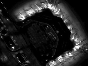 Previews of ~70-cm EROS B imagery collected during the night over Dallas-Fort Worth Airport on September 14, 2008. (Images Courtesy: ImageSat International)
Dear,
At EUROSENSE, we are currently working with nighttime satellite imagery, with the purpose of detecting and quantifying anthropogenic light emissions over major European urban centres. This is within the framework and context of the FP7 Decumanus research project; however, in the future, we also want to expand these results to commercial applications.
Until now, we were mostly working with coarse-resolution imagery of Suomi-NPP VIIRS (DNB band) and our own airborne luminance products. However, the EROS-B nighttime imagery capabilities seem to fit perfectly for our purposes. We are planning to perform some tests and validations on the data before starting to use it operationally.
Therefore our request: is it possible to receive some sample data for research and testing? evidently, this data would not be used publicly nor commercially.
Preferably, acquisitions one of the following cities (involved in the research project) would be suitable: Antwerp, London, Helsinki, Madrid, MIlan.
Sample data should not include the entire city, but a multi-temporal time series would allow us to investigate the possibilities of monitoring city light emissions over time.
Thanks in advance,
and best regards,
Tom Akkermans
EUROSENSE BELFOTOP BVBA
Wemmel, Belgium.