
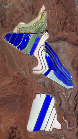
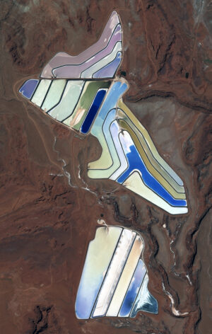
 These two satellite images show an overhead view of the Intrepid potash evaporation ponds near Moab, Utah. In the Pléiades Neo 3 30-cm color image from May 12, 2022, we can see the brilliant hues of the evaporation mines. In the second Pléiades 1B 50-cm color image taken on September 9, 2019, the brillant colors of the evaporation ponds are dulled down. These images have custom processing and color balancing applied by Apollo Mapping. PLEIADES © CNES 2026, Distribution Airbus DS.
In February, we looked at the historic Longwood House on St. Helena. This month for the Pléiades 1 – Pléiades Neo Point of Interest, we check out potash evaporation ponds near Moab, Utah.
About the Point of Interest: The Intrepid Potash Cane Creek Mine can be found along the Colorado River, about 20 miles west of Moab, Utah, not far from the Union Pacific Railroad.
Fun Factoids: (1) According to USGS reports, the Paradox Basin contains up to 2.0 billion tons of potash, with the primary mine being the one at Cane Creek. (2) The plant was built by the Texas Gulf Sulphur Company in the early 1960s, opening in 1963 as a conventional underground mine. (3) In 1963, an explosion trapped 25 miners of whom only seven were able to survive by building a barricade to trap fresh air. (4) In 1970, operations were changed to a system that combines solution mining and solar evaporation. River water is pumped into the mine and dissolves the potash, after which the brine solution is pumped to nearby evaporation ponds. (5) Intrepid bought the mine in 2000 from the Potash Corporation of Saskatchewan, which had bought it from Texas Gulf in 1995. (6) The potash mine also is known for its striking blue evaporation ponds visible from State Route 279 (Potash Road) and satellite imagery views.
The 50-cm Pléiades 1 High-Resolution Satellite Constellation
The Pléiades 1 constellation (or at least part of it!) has been in orbit since December 2011 and if you have not had a chance to check out any sample imagery, take a few moments and have a look at the gallery on our website. If you work with high-resolution imagery, you should consider Pléiades 1 and Pléiades Neo for your next geospatial projects.
A variety of Pléiades 1 products are available from both a well-established archive and as a new collection, including 50-centimeter (cm) pansharpened imagery and 50-cm panchromatic – 2-meter (m) 4-band multispectral bundles. We are happy to discuss the technical specifications, pricing and tasking options available with both of these satellite constellations.
The 30-cm Pléiades Neo High-Resolution Satellite Constellation
Pléiades Neo is our newest high-resolution satellite constellation. The first Neo satellite went up in April 2021 and the second in August of the same year. This 30-centimeter resolution constellation will add two more satellites in the next few months and upgrade from daily to intraday revisits. Pléiades Neo has six multispectral bands with 1.2-meter resolution, including a deep blue and two infrared bands, along with a 30-centimeter resolution panchromatic band.
The archive is growing every day, and the satellites are available for new collections, making Pléiades Neo the perfect solution for site monitoring. Check out our beautiful sample images in the Pléiades Neo gallery.
More sample images and technical information about Pléiades 1 can be found on our website here; while the same can be found here for the Pléiades Neo constellation.
The Apollo Mapping sales team can answer any questions you might have about Pléiades 1 and/or Pléiades Neo. We can be reached at (303) 993-3863 or sales@apollomapping.com.

Leave a Reply