Our Changing Landscape – Lake Geneva, France
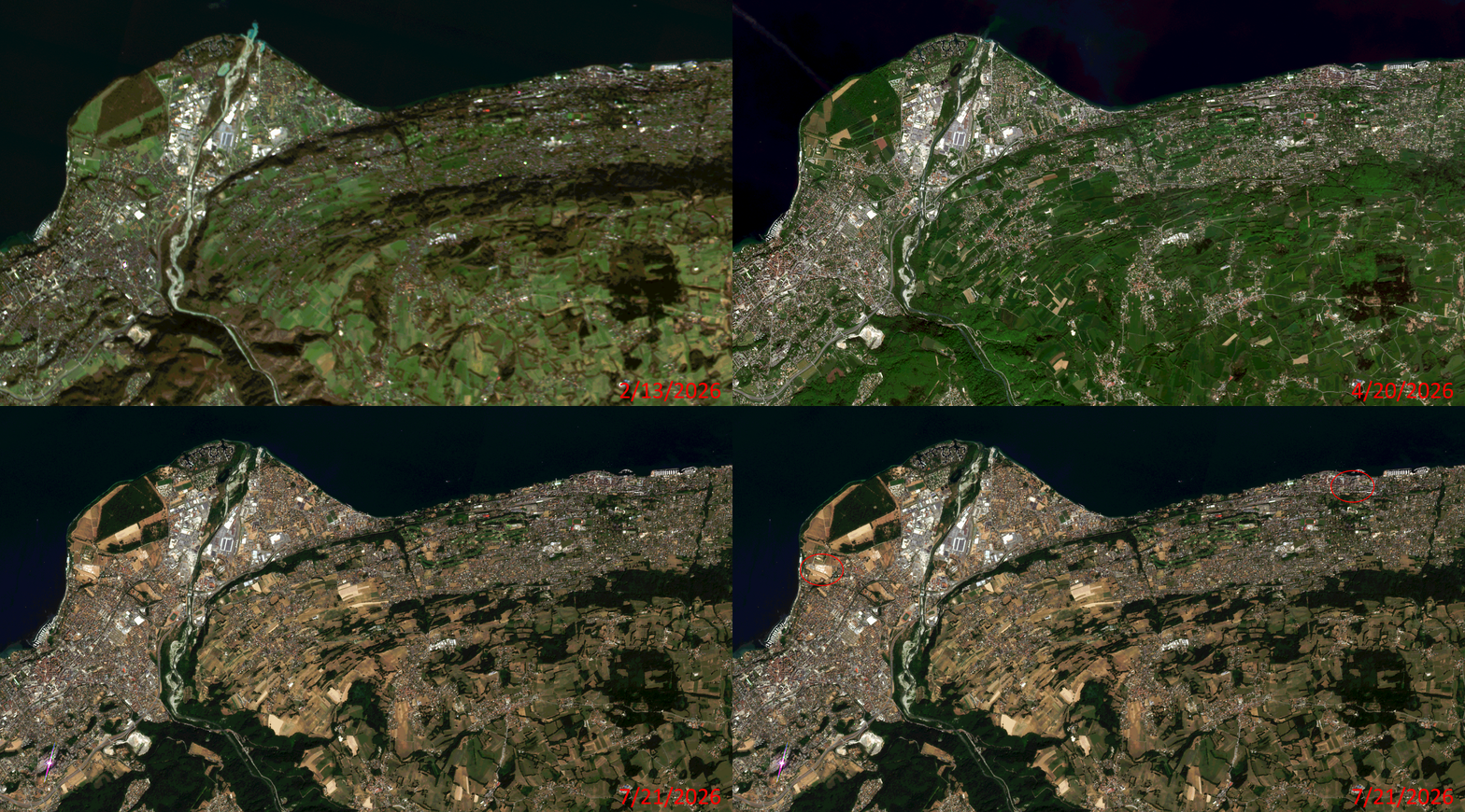
Click on the image above to see an animation of 3-meter natural color PlanetScope image collected over Lake Geneva, France on February 13, April 20, and July 21, 2026. In this animation, we can see just how much the droughts over much of Europe this summer impacted the landscape as this is typically a lush green region, but in the July 21st image, it sadly looks like a desert landscape. We have also circled both the start and finish lines for Stage 16 of the Tour de France which would have been underway when the 3-m PlanetScope image from July 21st was collected! (Images Courtesy: © Planet 2026)
In this monthly feature, we span the globe to examine Our Changing Landscape with a time series of medium-resolution PlanetScope satellite imagery. The PlanetScope constellation dates back to 2016 and collects hundreds of millions of square kilometers of four and eight-band 3-meter imagery daily! In October, we stopped at the beautiful island of Tristan da Cunha. For the November edition of this series, we travel to the shores of Lake Geneva in France.
Do you enjoy the high-resolution satellite imagery we post monthly in this article and elsewhere in The Geospatial Times? If so, head over to our Reddit subgroup, HighResSatelliteImage, where we post some our favorite high-resolution satellite images on a weekly basis.
The PlanetScope Microsat Constellation
PlanetScope is a constellation of more than 240 microsats referred to individually as Doves. Each Dove is able to collect up to 20,000 square kilometers (sq km) per day of 3-meter (m) 4-band multispectral (i.e. blue, green, red and near-infrared [NIR]) imagery; and newly launched SuperDoves collect 8-band multispectral adding in valuable red-edge spectral data. Across the constellation, PlanetScope is archiving more than 200 million sq km of medium-resolution imagery a day, making it the go to source for daily imagery over most locations. This massive archive dates back to 2016, offering the most complete and continuous record of spatial data on the planet since the start of the constellation’s ongoing launch schedule. Collecting 3-meter multispectral imagery is the equivalent of ‘high-resolution’ multispectral data imaged by a 75-centimer (cm) satellite (as this satellite would feature 75-cm panchromatic and 3-m multispectral), making PlanetScope an extremely competitively priced option at just $2.25 per sq km. With well registered images and nearly daily collections of most locations, PlanetScope is the ideal imagery source for this current-events focused series, Our Changing Landscape.
Lake Geneva & The 2026 Tour de France
In eastern France along the border of Switzerland sits Lake Geneva, which is near Evian les Bains and Thonon les Bains. Lake Geneva is a deep lake on the north side of the Alps and one of the largest lakes in western Europe, as well as the largest on the course of the Rhône. Sixty percent of the lake belongs to Switzerland (the cantons of Vaud, Geneva and Valais) and 40% to France (the department of Haute-Savoie).
Evian les Bains happens to be an upmarket holiday resort and spa town on the shores of Lake Geneva that has been visited by royalty such as Kings Edward VII and George V of the United Kingdom and King Farouk of Egypt, and celebrities such as Countess Anna de Noailles and Marcel Proust. Thonon-les-Bains, or simply Thonon, is part of a transborder metropolitan area known as Grand Genève situated on the shores of Lake Geneva.
In the 3-m PlanetScope animated image featured here, you can see brown fields full of dead foliage in the July image due to a severe drought impacting France and a considerable amount of Europe this summer, which experts attribute to climate change. According to the European Drought Observatory (EDO), more than 85% of the country was under drought warning or alert conditions in mid-July 2026, compared with around 65% at the same time in 2025, and less than 2% in 2024, a summer without widespread drought.
Within the two red circles featured on the four slide of our animation, we find the start line of the Tour de France stage 16, as well as the finish line for this stage. These two locales are at opposite ends of the image, showing how far the bicyclists must travel for just one stage of the race. It’s easy to see the tents set up for the event, plus vehicles scattered around. The race was a 26.1-kilometer individual time trial from Évian-les-Bains to Thonon-les-Bains held on July 21, 2026. World time-trial champion Remco Evenepoel won the stage in 32 minutes and 19 seconds, beating yellow jersey holder Tadej Pogačar by 28 seconds.
If you would like to find out more about using 3-meter PlanetScope imagery for your academic studies, engineering projects or any landscape analysis, let us know at sales@apollomapping.com or (303) 993-3863.