
Last month we are unveiling the new and improved Image Hunter, have you checked it out yet?!?! If not, you should!
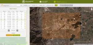
Listening to the feedback we received over the past months, the new version of Image Hunter features a major overhaul to the user interface as well as to the backend architecture. Image Hunter Version 2 is built on open-source technology so now it works on all computers, not just on Windows machines. We slimmed down the user interface to make it easier to find the imagery filters and other available tools. Image Hunter is now lightening fast with better previews and the option to search for RapidEye imagery.
All things said, we really think you will enjoy your new imagery browsing experience with Image Hunter (Version 2). Launched in July, we fully expect to find ways to improve its user interface and operability. In the past month, we have spent significant time and effort on improving the speed and stability of imagery searches for all of the 1-meter and higher resolution datasets.
If you have any ideas and/or feedback to improve the new Image Hunter, please let us know at sales@apollomapping.com or (303) 993-3863.
Image Hunter can be accessed 24 hours a day, 7 days a week and is a one-stop shop for every major source of medium and high-resolution satellite imagery on the market today, including:
- WorldView-2
- QuickBird
- WorldView-1
- GeoEye-1
- IKONOS
- The Pléiades 1 constellation
- The entire SPOT constellation
- RapidEye
If any of our readers have struggled with other geospatial search engines that are clunky, only query one data source and/or do not provide preview images, then Image Hunter is the solution to your woes, as it features:
- Online browsing of satellite imagery from 4 data providers and 14 satellites.
- Near-instantaneous loading of low resolution preview imagery with collection date, cloud cover and other key metadata.
- The ability to define your area of interest by address and with coordinates, geometric shape or shapefile/KMZ.
- Responsive basemap with street names to provide a spatial context when discovering data as well as crowd sourced updates for the most accurate map possible.
- Exports of the area of interest you create as well as the scenes you select in shapefile or KMZ format.
- Support for all operating systems, and not just our friends with Windows machines!
The new version of Image Hunter can be accessed here. We are excited to find out what you think about Version 2!

Leave a Reply