
Welcome to the first editions of our regular feature, Free For All! In these short pieces, Katie and I will point our Geospatial Times readers to the favorite free item we found that month for those in GIS and remote sensing.
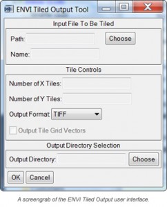
Not too long ago I ran into a problem trying to export a large image file as a GeoTIFF given that the image exceeded the maximum file size of 4GB. I considered subsetting the image using regions of interest in ENVI, but this seemed like a lot of unnecessary effort. I thought to myself, ‘There has to be an easier way to do this!’ Lo and behold there is a much easier way to subset an image with ENVI. Thanks to Exelis’ code library and the mighty programming of Dave Hulsander, there is a free GUI that you can download by following this link.
The GUI creates a new button in the ‘Basic Tools’ drop-down menu and with it you can specify the number of tiles in the X and Y directions and the output file format. It also appends the row and column number to the image title so they are easy to spatially identify. You can even save the vector grid file. This month’s Free For All lesson: you’re not always stuck with what you got!

Leave a Reply