
Do you work in urban planning, environmental monitoring, or resource management and are tasked with identifying land use, tracking changes in urban areas, assessing forest health, and planning development projects? If so, high-resolution imagery with its large concentration of pixels for greater detail enables precise analysis and measurement of features not visible in lower-resolution images, allowing for accurate mapping, less need for site visits, and detailed documentation of our real world.
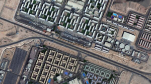 A 30-cm WorldView Legion image courtesy of Maxar collected over the NEOM Campus in Saudia Arabia on December 2, 2024. Apollo Mapping has applied custom color balance and image enhancements.
Since its launch in 2024, 30-centimeter (cm), 8-band WorldView Legion is one of the most prolific 30-cm satellite constellations available in the high-resolution satellite imagery sector. With six satellites currently in orbit, the WorldView Legion constellation captures approximately 3.2 million square kilometers (sq km) of high-resolution 30-cm imagery daily which is added to Image Hunter (nearly) instantly. Additionally, its advanced multispectral sensor captures data across eight different wavelengths, offering exceptionally detailed perspectives of Earth’s surface; and facilitating the identification of small objects and the detection of subtle environmental changes in both urban and natural settings. Advanced applications such as bathymetry, vegetation assessment, mineral exploration, and wildfire monitoring are common use cases for 30-cm WorldView Legion satellite imagery.
With 90% of the world’s population residing between 45° North and 45° South latitudes, the constellation is optimized for quicker revisit intervals in these regions, while maintaining coverage of higher latitudes with two sun-synchronous satellites. Four WorldView Legion satellites circle the planet in persistent mid-latitude orbits. The WorldView Legion constellation operates across multiple orbital paths with a 10-km footprint at nadir, enabling frequent revisits – in fact, up to 15 times daily in select regions. This increased capacity and revisit rate for the most populated areas of the world creates a robust archive and advanced monitoring capabilities in these crucial regions. The revisit frequency supports comprehensive mapping, robust change detection, and in-depth analysis over extensive geographic areas. These capabilities allow the 30-cm WorldView Legion to support a wide range of geospatial applications, including projects requiring spectral analysis and intense detail.
With six active satellites in orbit, the WorldView Legion constellation stands out for:
- 30-cm panchromatic and 1.2-m 8-band multispectral imaging (coastal, blue, green, yellow, red, red edge 1, red edge 2, NIR).
- Offering four middle-orbit (MIO) satellites concentrated on the most populous areas of the planet.
- Imaging 500,000+ sq km daily from each satellite.
- Delivering an average of three daily accesses to locations between 40° North and South.
- Capturing images throughout the day, not just mornings, thanks to its MIO satellites.
The 30-cm WorldView Legion constellation allows Apollo Mapping to offer increased high-resolution imaging capacity and faster delivery times to customers across various sectors, including defense, mining, oil and gas, engineering, education and research, and humanitarian relief.
You can explore our entire satellite imagery archive today on Image Hunter!
To see how 30-cm, 8-band WorldView Legion imagery can support your next project, or get personalized recommendations, contact our sales team at sales@apollomapping.com now.

Leave a Reply