
We love maps.
We love imagery.
We love work breaks.
We hope you like them as well!
Every year in Nevada’s Black Rock Desert, tens of thousands of people flock to Burning Man, a nine-day event that focuses on community, art, self-expression, and radical self-reliance. Rather than a traditional festival, Burning Man establishes a temporary, participant-created city (Black Rock City) that operates on a “gift economy” without money, vendors, or corporate sponsorship. The event ends with the ceremonial burning of a large wooden effigy.

Burning Man 2025 sported the theme “Tomorrow Today,” and was held from August 24th to September 1st. The event explored themes of the future, innovation, and cultural exchange, drawing inspiration from the world fairs of the past. While everyone’s aware of the actual burning of the man on Saturday and burning of the Temple of the Deep on Sunday, there’s plenty of other activities that eventgoers enjoy.
There’s daily sound healing, sunrise sets, various workshops, a coloring book station, bike limo, Butt Battle (backwards sumo), areas with adult beverages and food, large-scale interactive art, experimental sculptures, music, and thematic camps. There aren’t any headliners or scheduled performers; attendees (often called “burners”) create all art, performances, and theme camps.
For this month’s Imagery Work Break, we have a 50-centimeter SkySat color image collected on August 31, 2025. In the image, we can see the endless stream of vehicles, tents, artists, music stages, and more packed into the Burning Man’s spot in the desert. The image reflects just how many people show up for the annual Burning Man event. We have featured Burning Man many times in The Geospatial Times, you can find past editions here.
Do you enjoy the high-resolution satellite imagery we post monthly in this article and elsewhere in The Geospatial Times? If so, head over to our Reddit subgroup, HighResSatelliteImage, where we will post some our favorite high-resolution satellite images on a weekly basis.
Have a great rest of your workday! 😊
(Image Courtesy: Planet. Processed by Apollo Mapping for improved grey-scale accuracy and clarity.)
Every person is unmistakably unique, yet most of us spend our lives looking for connection – for signs that our private experiences belong to a larger human pattern. The brain may be one of the best places to look. Imagine it’s not finished, but as a structure under constant construction: wired with basic necessities, shaped by use, remodeled by time, and always leaving room for expansion.
Buildings have eras. Anyone who has inherited an older home knows the evidence: a dated fixture, a tired roofline, a repair made by someone else’s hands, a room that no longer fits the life being lived inside it. Sometimes the problem is style. Sometimes it is wear. Either way, the structure changes with its caretakers – and it will change again when the next person arrives.
Our brains, it turns out, have eras too. Scientists at the University of Cambridge identified five ages of the brain, marked by major turning points around ages nine, 32, 66, and 83. The finding is striking because it suggests brain development is not a smooth, steady climb from childhood to old age. It is more like a series of renovations – periods when neural wiring shifts to support different ways of learning, adapting, stabilizing, and aging. One detail especially stops me: the adolescent phase may last until about age 32. Think of all the life that happens between nine and 32 – the classrooms, friendships, jobs, heartbreaks, risks, responsibilities, and discoveries. If the brain is still actively reorganizing through all of that, then a powerful question follows: how do our choices, work, tools, and habits shape each era of development?
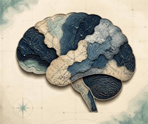
Created in Canva by B. Duke
The case for everyday influence is hard to miss. A growing body of public health and medical guidance links lifestyle with cognitive health, and Dr. Gajendra at Nivok Specialty Hospital highlights several familiar choices that affect brain health:
- Food matters. Fruits, vegetables, and nourishing meals support the brain far better than a steady diet of sugary, highly processed foods.
- Movement matters. Regular physical activity increases blood flow to the brain and supports memory, growth, and resilience.
- Sleep matters. Rest gives the brain time to repair, consolidate memory, and reset for the next day.
- Stress matters. Long-term stress can strain the brain and interfere with healthy function.
- Substances matter. Smoking, excessive alcohol use, and drug use can impair brain function and reduce oxygen reaching brain cells.
And the list does not end with what we eat, how much we move, or how well we sleep. Another article points to social connection as part of brain health too. In other words, the brain is not remodeled only in gyms, kitchens, and bedrooms. It is also shaped in conversations, collaborations, classrooms, communities, and the shared work of paying attention together.
A recent study on magic mushrooms adds another layer to the story. It describes how a naturally occurring chemical may help the brain move beyond familiar patterns during and after the experience. Participants who showed greater increases in flexible, varied brain activity also reported more personal insight and later improvements in well-being. The broader idea is compelling: changing how we think – or how we perceive our lives and circumstances – is not a soft skill. It may be one of the most important forms of adaptation we have.
I saw this kind of shift firsthand when I used GIS to help students understand literature. At first, geospatial tools seemed like a way to make an abstract subject more concrete. Maps, patterns, and spatial analysis gave students a new entry point into stories that once felt distant. But something else happened too. Their brains seemed to borrow the habit of spatial thinking and apply it elsewhere. They began to notice relationships, movement, context, and evidence in new ways. My classroom observations were not formal research, but they align with studies that connect geospatial technology with improved reasoning. In a 2019 ArcWatch article, Dr. Bob Kolvoord described research in which students in the Geospatial Semester showed “greater blood flow in the parietal region of the brain, an area related to spatial reasoning, from pretest to posttest compared with a control group.”
For geospatial professionals, this is not abstract. Every hour spent wrangling data, exploring patterns, comparing layers, scanning imagery, and solving spatial problems has changed the way you notice the world – whether you meant it to or not. Details that are invisible to others become obvious to you. A parking lot becomes a flow pattern. A hillside becomes a record of water, vegetation, and human choice. Aerial and satellite imagery from tools like Image Hunter trains the eye to recognize big green circles, subtle boundaries, and sweeping variations in landform. Even non-map tasks begin to feel different: scanning code, reading dense text, spotting anomalies, and finding the one empty parking space in a crowded lot.
That may be the quiet gift of geospatial work. It does not simply teach us to make better maps. It teaches us to live with a different kind of attention.
If the brain has eras, then perhaps our daily practices are the renovation plans. We build through what we study, what we repeat, what we notice, and who we notice it with. For those of us shaped by maps and spatial thinking, the structure has already changed. We do not just look at the world. We read it.
If you need me, I’ll be working through the stack of books on my “must read” shelf.
Barbaree Duke
Geospatial Crusader
- We follow up a large July list of technological advancements with another massive list here in August – enjoy!
A new nasal spray could reverse brain aging.
Rouge moons circling starless planets could harbor life.
A more sustainable way to desalinate seawater.
Sea sponges can help us discover new molecules for potent drugs.
A more efficient system to directly produce fuel from sunlight.
Major step forward with catalyst for energy production from CO2.
This hidden fungal network helps control the world’s climate.
A more efficient way to breakdown forever chemicals.
An efficient system to convert carbon dioxide to methanol.
New material to protect electric transformers.
Our Solar System may have lost at least one early planet.
Have you ever wondered how a honeybee becomes a queen?
Sunlight driven desalination system also leaves no waste brine behind.
This material can increase the energy of a photon.
From waste ocean plastics to asphalt roads.
A new way to target and fight cancer.
Water can improve diesel fuel efficiency and reduce pollution.
A new life for spent EV batteries.
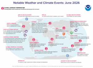 North America recorded its second warmest June on record while Europe’s June temperature tied as the second warmest on record. India experienced one of its driest Junes on record and Africa experienced its second warmest June. Tropical Storm Arthur brought gusty winds and heavy rain to parts of the Gulf Coast and southeastern U.S., while Tropica Storm Cristina produced prolonged periods of heavy rainfall and torrential rains that triggered flash floods and overflowing rivers. Hong Kong also experienced historic torrential rains that caused widespread flooding. Super Typhoon Mekkhyala, a category 4, dumped heavy rain and brought gusty winds and storm surges to parts of the Philippines, Taiwan and Japan. (Image Credit: NOAA Global Climate Report)
- The Global Climate Change Report for June 2026 has been released by NOAA’s National Centers for Environmental Information and reveals further proof that global climate change remains a concern. The June 2026 global surface temperature was 1.09°C (1.96°F) above average – the second warmest June in the 177-year record. This value was 0.09°C (0.16°F) below the 2024 record and only 0.02°C (0.04°F) above June 2023, which currently ranks as the third warmest June on record. The 10 warmest Junes on record have all occurred since 2015, with each of the last eight years (2019–2026) ranking among them. Additionally, this month marked the 50th consecutive June with global temperatures above the 20th Century average; the last below-average June occurred half a century ago in 1976 (-0.05°C / -0.09°F). The global ocean temperature departure for June was the highest on record at 0.99°C (1.78°F) above average, eclipsing the previous June record set in 2024 by 0.04°C (0.07°F). Across all 2,118 months in the historical record since January 1850, June 2026 tied with July 2023 as the seventh-highest global ocean temperature departure. Meanwhile, global land surface temperatures ranked as the fourth warmest on record for the month.
- Pumpkin and pecan pies are popular around Thanksgiving while mint and key lime pies are perfect for the green-themed St. Patrick’s Day. Blueberry and strawberry pies help herald in the Fourth of July with their red, white, and blue colors; and good ol’ cherry pie rings true any time of the year. Regardless of your favorite flavor of pie, be sure and celebrate Homemade Pie Day on August 1st! People are encouraged to bust out their rolling pin and whip up a sweet or savory pie from scratch. If you need inspiration for Homemade Pie Day, draw upon GIS mapping technology to find recipes from around the world that would appeal to your palate. RecipeDB is a structured compilation of recipes, ingredients and nutrition profiles interlinked with flavor profiles and health associations. The database consists of 118,171 recipes from cuisines across the globe (6 continents, 26 geocultural regions and 74 countries), cooked using 268 processes (heat, cook, boil, simmer, bake, etc.), by blending more than 20,262 diverse ingredients, which are further linked to their flavor molecules (FlavorDB) and nutritional profiles (U.S. Department of Agriculture). Edamam indexes more than 2.3 million recipes and offers APIs for diet filters, nutrition breakdowns, and chronic condition analysis. The U.S. Department of Agriculture’s SNAP-Ed Connection’s Recipe Finder offers a nutrition-focused database that features yield-tested recipes with cost estimates.
Brock Adam McCarty
Map Wizard
(720) 470-7988
brock@apollomapping.com
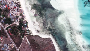 A meal at The Rock is like no other. Patrons must boat out to a giant rock on which the restaurant is perched, offering breathtaking views of the ocean stretching beyond. The Rock was founded in 2011 by Andrea Brunetti, Claudio Moras, and Nigel Firman. It quickly became an iconic destination known for its beautiful setting, mouthwatering cuisine, and Italian hospitality. It’s nestled on the shores of Michamvi Pingwe Beach in Zanzibar, Tanzania. Nigel first discovered the rock while strolling along the beach. The rock was a fisherman’s outpost, and after a lengthy process building strong community relationships, local fishermen were convinced to lease the rock to Nigel and Andrea. But it’s not just the views that impress guests. The menu features locally sourced Zanzibari ingredients that blend together for an impressive culinary adventure, including seafood harvested from the reefs around the restaurant, fish caught daily by local fishermen, and spices from Zanzibar’s spice farms. They combine traditional Italian cooking techniques with innovative twists to showcase the vibrant flavors and aromas of Zanzibari cuisine. On the menu, The Rock Special features lobster, king prawns, octopus, and calamari from the grill. There’s also the grilled fish fillet catch of the day served with carrots, ginger cream, vegetables, and crispy and spicy chips. The stewed rock lobster comes with cous-cous, greens, ginger and lime. There is English-style roast beef, golden fried vegetables with mango, and tempura for just a few of the appetizer options; and a section of the menu dedicated to home pastas such as Zanzibarian dumplings, seafood paccheri, and creamy purple cauliflower soup. Desserts range from a simple fresh fruit mix with vanilla ice cream to a Zanzibar passion ring, and a Chocococco. Sitting in the frothy beachfront water can be seen the restaurant on the rock. We can see the tiers of the ocean as the water stretches outward. The 30-cm WorldView Legion image featured here was collected on November 2, 2024, and has custom processing and color balance applied by Apollo Mapping. (Satellite Imagery © 2026 Vantor)
In this monthly article, we travel the world to check out unique, fun and sometimes a bit weird 30-centimeter (cm) color imagery samples from the WorldView constellation. In July, we looked at El Alma del Ebro at Plaza Lucas Miret in Zaragoza, Spain. For this edition of the 30-cm Color WorldView Image of the Month, we feature an image of the Rock Restaurant in Zanzibar.
Do you enjoy the high-resolution satellite imagery we post monthly in this article and elsewhere in The Geospatial Times? If so, head over to our Reddit subgroup, HighResSatelliteImage, where we will post some our favorite high-resolution satellite images on a weekly basis.
30-cm WorldView-3 (WV3) launched in late 2014, WorldView-4 (WV4) launched in late 2016 and then the first WorldView Legion satellites launched in 2024. Taken together, this is the most advanced satellite constellation the commercial marketplace has ever had access to. Here are a few of the features that really set these satellites apart from the competition:
- Improved Resolution
- Higher resolution means you can see more detail in WorldView imagery.
- Data collected at nadir will have 31-centimeter (cm) panchromatic, 1.24-meter (m) visible and near infrared, 3.7-m SWIR (WV3 only) and 30-m CAVIS (WV3 only) bands.
- Additional Spectral Bands
- If spectral analysis is part of your project, then no other satellite can match WorldView-3 and WorldView Legion with their 8 bands of visible and near-infrared data; and then 8 shortwave infrared bands (WV3 only) which are crucial for geological studies.
- Better Positional Accuracy
- With accuracies of 3.5-m CE90% or better (without ground control even!), the 30-cm WorldView constellation has no rivals for its enhanced positional accuracy.
- Daily Revisits
- With multiple WorldView-3 and WorldView Legion satellites orbiting our planet, daily revisits are available for most locations.
- WV4 is no longer collecting new imagery.
- Increased Collection Capacity
- WV3/4 feature 13.1-km swath widths (at nadir) with the ability to collect up to 680,000 square kilometers (sq km) of high-resolution data per day per satellite (though WV4 is dead now).
- WorldView Legion features six 30-cm satellites, significantly boosting the collection capacity of this leading high-resolution constellation.
If you are interested in WorldView-3, WorldView-4 and/or WorldView Legion imagery for your next project, please let us know by phone, 303-993-3863, or by email, sales@apollomapping.com.
You can also find more WV3 samples and technical information on our website here; WV4 samples and information can be found here; and then finally here is more information about WorldView Legion.

Cricket’s Chirp is created for Apollo Mapping by Ron Ruelle, a Northwest Ohio (formerly Boulder, CO) based cartoonist, lllustrator and teacher. No animals are harmed in the creation of these comics, but Ron sometimes breaks a pencil in frustration. He has a new collection of his weekly Skelton Comics available at www.ronruelle.com
In June, we looked at Ulugh Beg Observatory in Samarkand, Uzbekistan. This month for the Pléiades 1 – Pléiades Neo Point of Interest, we travel to Schonbrunn Palace in Vienna, Austria.
About the Point of Interest: Thirty years ago, Schönbrunn Palace and Gardens and Schönbrunn Zoo were added to the UNESCO World Heritage List. Since then, Schönbrunn has been regarded not only as one of Austria’s most important cultural assets, but also as an internationally recognized cultural monument and a popular destination for visitors from all over the world. At the end of the 17th Century, Emperor Leopold I commissioned the Baroque architect Johann Bernhard Fischer von Erlach, who had received his training in Rome, to design an imperial hunting lodge for his son, Crown Prince Joseph, later to become Emperor Joseph I. Replacing the Château de Plaisance built on this site for the dowager empress Eleonora of Gonzaga in 1642, it was to grow into a palatial imperial residence over the course of the 18th Century. The palace and gardens of Schönbrunn are among the most impressive and best-preserved Baroque ensembles in Europe. The symmetrical layout and design of the gardens are inextricably linked to the palace building. Schönbrunn Palace and its extensive outbuildings are the epitome of an imperial residence that had to meet many requirements: the palace provided for a prestigious court in magnificently furnished halls as well as comfortable living quarters for the imperial family, while the side wings housed service and administrative rooms and quarters for the court staff.

 These two satellite images show an aerial view of Schonbrunn Palace in Vienna, Austria. You can see the incredibly spacious, park-like garden with its winding paths and monuments in the 50-cm Pléiades 1B enhanced color image taken July 16, 2023. Marvel over the geometric shapes of the palace, too, captured in the 30-cm Pléiades Neo 3 enhanced image taken September 3, 2022. PLEIADES © CNES 2026, Distribution Airbus DS.
Fun Factoids: (1) Schönbrunner Schloßcafé offers specialty coffees and teas, breakfast foods, Viennese cakes, pastries and hot snacks to guests. (2) There are eight shops with a wide range of items to offer guests what’s called an imperial shopping experience. Products range from small souvenirs to exquisite luxury items, offering something to suit every taste. (3) The park at Schönbrunn Palace was opened to the public around 1779 and since then has been a popular recreational amenity for the Viennese population as well as a focus of great cultural and historical interest for international visitors. (4) The park originally was named “Katterburg” and was used as a hunting ground by the Habsburgs, eventually being transformed into a picturesque Baroque complex under Franz I Stephan of Lorraine. (5) In the possession of the Habsburg dynasty since Maximilian II, as former court property the palace passed to the ownership of the Republic of Austria at the end of the monarchy in 1918 and was administered by the Schlosshauptmannschaft Schönbrunn (a local government body) until 1992; which is when Schloss Schönbrunn Kultur- und Betriebsges.m.b.H. was founded and entrusted with the administration of the palace as a limited-liability company solely owned by the Republic of Austria. (6) Following the death of Maria Theresa in 1780, the palace at Schönbrunn was not used again until the reign of Emperor Franz II in the early 19th Century. When preparations for the Congress of Vienna in 1814/15 were being made, it became clear that Schönbrunn was in need of renovations and refurbishing to bring it up to date. The renovation of the façade concluded the work and, under the supervision of court architect Johann Aman, the palace was given the characteristic appearance it still retains today.
The 50-cm Pléiades 1 High-Resolution Satellite Constellation
The Pléiades 1 constellation (or at least part of it!) has been in orbit since December 2011 and if you have not had a chance to check out any sample imagery, take a few moments and have a look at the gallery on our website. If you work with high-resolution imagery, you should consider Pléiades 1 and Pléiades Neo for your next geospatial projects.
A variety of Pléiades 1 products are available from both a well-established archive and as a new collection, including 50-centimeter (cm) pansharpened imagery and 50-cm panchromatic – 2-meter (m) 4-band multispectral bundles. We are happy to discuss the technical specifications, pricing and tasking options available with both of these satellite constellations.
The 30-cm Pléiades Neo High-Resolution Satellite Constellation
Pléiades Neo is our newest high-resolution satellite constellation. The first Neo satellite went up in April 2021 and the second in August of the same year. This 30-centimeter resolution constellation will add two more satellites in the next few months and upgrade from daily to intraday revisits. Pléiades Neo has six multispectral bands with 1.2-meter resolution, including a deep blue and two infrared bands, along with a 30-centimeter resolution panchromatic band.
The archive is growing every day, and the satellites are available for new collections, making Pléiades Neo the perfect solution for site monitoring. Check out our beautiful sample images in the Pléiades Neo gallery.
More sample images and technical information about Pléiades 1 can be found on our website here; while the same can be found here for the Pléiades Neo constellation.
The Apollo Mapping sales team can answer any questions you might have about Pléiades 1 and/or Pléiades Neo. We can be reached at (303) 993-3863 or sales@apollomapping.com.

We love maps.
We love imagery.
We love work breaks.
We hope you like them as well!
Warmer weather has draped itself across the country as spring arrived this month, bringing with it all the excitement for outdoor activities. Tennis enthusiasts have hit the courts, swinging their rackets and gearing up for matches with friends or tournaments against competitors.
This summer, the 2026 Wimbledon, the 139th edition of the tournament, will run from Monday, June 29, to Sunday, July 12, 2026, at the All England Lawn Tennis and Croquet Club in London. As the premier grass-court event, it features top-tier ATP/WTA action, including gentlemen’s and ladies’ singles, doubles, and wheelchair tournaments. The tournament starts with early-round singles on Monday and concludes with the finals in the second week. This year marks a significant change, organizers say, with fully automated live electronic line calling (replacing human line judges) in use for all matches.
But before we look ahead to this summer, we can’t forget what happened in the 2025 women’s single final match at Wimbledon. Iga Świątek won the 2025 Wimbledon women’s singles title on July 12, 2025, defeating Amanda Anisimova 6–0, 6–0. This dominant victory marked Świątek’s first Wimbledon title and sixth major overall, becoming the first Polish player to win a Wimbledon singles title in the Open Era. It was Swiatek’s first Grand Slam title since the 2024 French Open. Świątek won six Grand Slam championships and has won at least one on all three surfaces. She won 20 straight games to finish the 2025 tournament, dating back to her semifinal victory.
For this month’s Imagery Work Break, we feature an oblique image collected by GeoEye-1 at 61-centimeter resolution. It just so happens this GeoEye-1 image was collected on July 12, 2025, the same day as the women’s single title between Anisimova and Świątek. Records are set here and there’s sure to be more made this summer, too. Don’t forget to tune in for the 2026 Wimbledon and maybe you’ll see history made again.
Have a great rest of your workday! 😊
(Image Courtesy: Vantor. Processed by Apollo Mapping for improved grey-scale accuracy and clarity.)
If you are searching for medium and high-resolution satellite imagery, the search is over as Image Hunter is the solution you’ve been looking for! Featuring satellite and aerial imagery as well as digital elevation models (DEMs) from a constantly expanding list of 70+ constellations/datasets and 19 vendors, our database contains more than 500-million images/records meaning there is just no other website out there with this breadth of commercial data products. Our interface is slim-lined and modern, loading quickly on all platforms, browsers and operating systems. Further, our database is updated multiple times an hour with the most recent images collected by WorldView-3, Pléiades 1, PlanetScope, SuperView Neo and many more so you are sure to get the most current view of all the imagery and DEM databases we work with. Once you submit your request, an Apollo Mapping representative will be in touch within 4 Illinois business hours to get you the pricing information you need for your project.
So why wait? Give Image Hunter a try now to find the imagery and/or DEM data you need for your next mapping project!
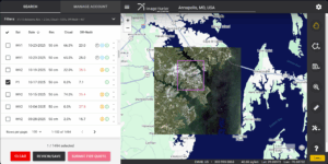
 Our new Clip Polygon To Image tool is live! Give it a try to automatically calculate the coverage areas of a complex set of imagery from various data vendors and satellite constellations.
Key Improvement(s) From The Past Month
The past month has seen us take a little time to regroup and refocus our efforts while we make plans for the rest of the business year. We also put significant effort into massive backend overhauls to support some new ideas we should be pursuing in the near-ish future. Stay tuned for more exciting news coming in the next months as we fine tune the Clip Image to Polygon tool and move on to the next major additions to the system.
Here is a summary of the changes/improvements we made to Image Hunter during the past month:
- Fixed a series of small bugs and improved the workflow for the Clip Image to Polygon tool.
- Optimized the loading process for both Vantor and Airbus image previews.
- Applied the correct name to 50-cm digital elevation data from the Vivid Terrain series as well as updated our vendor’s name to Vantor.
- There is a new vendor API for 22-meter GS1, we updated our system to use it.
Data Alert – An Automated Daily Imagery Search
Have you checked out Data Alert which lets you define an area of interest anywhere around the globe, the resolution your project requires and the number of months we should keep the alert active? Once an alert is set up, we check for new data over your area of interest every single day, and send you an email when we find coverage that meets your specifications. We have a short YouTube video with directions to set up a Data Alert, check out the last video; and we have written directions for Data Alert here.
The Sensors Available in Image Hunter
As you might have seen in past articles, we now feature hourly updates (seriously!) of GeoEye-1, KOMPSAT 3/3A, Pléiades 1 and Neo, SPOT 6/7, SuperView-1/2/Neo, WorldView-1/2/3/Legion!
Image Hunter can be accessed 24 hours a day, 7 days a week and is a one-stop shop for every major source of medium and high-resolution satellite (and aerial!) imagery on the market today, including:
- WorldView Legion
- WorldView-4
- WorldView-3
- WorldView-2
- WorldView-1
- QuickBird
- GeoEye-1
- IKONOS
- EROS B
- KOMPSAT-3A
- KOMPSAT-3
- KOMPSAT-2
- Pléiades 1 constellation
- Pléiades Neo constellation
- TerraSAR-X (TerraSAR-X, TanDEM-X and PAZ)
- GEOSAT-1
- GEOSAT-2
- TripleSat
- BJ3A
- BJ3N
- SPOT 1 to 7 constellation
- RapidEye
- GaoFen-2
- GaoFen-1
- ZiYuan-3 01/02 (mono and stereo!)
- FORMOSAT-5
- FORMOSAT-2
- ALOS PRISM (stereo)
- AW3D Standard (DEM)
- SkySat constellation
- PlanetScope constellation (including 5-band SuperDove data)
- SuperView-1 constellation
- SuperView-2
- SuperView Neo-1 01/02/03/04
- SuperView Neo-3 01/02
- Landsat 1-8
- TeLEOS-1
- DS-EO
- Hexagon (HxGN Content Program aerial imagery) imagery + DEM
- WorldDEM
- WorldDEM Neo
- Vricon DEMs
- Orbita Hyperspectral Satellite (OHS)
- KazEOSat-1
- KazEOSat-2
- Jilin-1 Optical
- Jilin-1 Video (including nighttime imagery)
- Jilin-1 GF/DP
- Jillin-1 KF
- Orbita Video Satellites-1/2/3 (OVS-1/2/3)
- BlackSky Global series
Key Features of Image Hunter
If any of our readers have struggled with other geospatial search engines that are clunky, only query one data source and/or do not provide image previews, then Image Hunter is the solution to your woes as it features:
- Online browsing of satellite and aerial imagery from 19 data providers and 56 satellite and aerial imagery derived datasets.
- Near-instantaneous loading of low-resolution preview imagery with collection date, cloud cover and other key metadata.
- The ability to define your area of interest by address, coordinates, geometric shape or shapefile/KMZ.
- A responsive basemap with street names to provide spatial context when discovering data as well as crowd-sourced updates for the most accurate map possible.
- Exports of the area of interest you create as well as the scenes you select in shapefile or KMZ format.
- Support for all operating systems, and not just our friends with Windows machines!
Image Hunter can be accessed here all day and night, we are excited to find out what you think about our imagery search engine! So if you have any ideas and/or feedback to improve Image Hunter, please let us know at sales@apollomapping.com or (303) 993-3863.