
 A 15-cm color sample of Hexagon aerial imagery from summer 2024 collected over Northstar California Resort by Lake Tahoe, California.
This month, Hexagon released new 15-centimeter (cm) resolution imagery of California, including DSM and stereo data, collected during the second half of 2024. They’re keeping up with their imagery updates in the US with Indiana, North Carolina and Wyoming coming soon.
Reach out to us at sales@apollomapping.com to lean more or check out the Hexagon archive anytime online at Image Hunter.
An expensive week. I knew I had the 60,000-mile tune-up coming on my car at the cost of $1,300, but just before that, my battery died, and that was another $250. Concurrently with the dead battery came an airbag sensor lighting up which was determined to be faulty in the passenger’s seat. That was estimated at $1,500–but that last one didn’t sit well with me. The battery dies and it blows a sensor? That’s not cool. I was past my warranty but had no interest in dropping that much cash, especially for something so seemingly trivial–and in a seat I don’t even sit in to boot. Well, I sent an email to Subaru, and they quickly offered a $1,000 credit to the dealer, which was nice, but I’m still out $500 for something that is just bogus. All in for the car at just over two grand.
At this time, I was also expecting to begin some crawlspace work to help control moisture and humidity, something that was causing my plaster to crack. After getting several estimates covering every possible option, I settled with one company to close my vents, install a dehumidifier, reroute the sump pump, and install an exhaust for a ground-level gases that you don’t want to get trapped and seeping up through the floorboards. This is going to come to about $3,500–which is a lot, but far short of the high estimate of a total encapsulation at $13K.
Not over yet. I also developed a leak in my ceiling, initially deemed to be the boot on the exhaust vent for the kitchen sink. While that had indeed wore out, there were also smaller leaks that were allowing water in as well–these were the result of an overzealous roofer from about three years ago. I’m currently trying to figure out if part of that fix will be covered by the roof warranty (good for 5 years), but for the other work, I’m guessing it’ll be close to $1,000. So, assuming I get lucky with the warranty, this week is going to cost me around $6,500, money I’d hoped to allocate elsewhere. What’s the saying? “Life is what happens when you’re busy making other plans.” Ain’t that the truth…
 Everybody wants my money. (Image retrieved from here and comes courtesy of Kaboompics.)
Thankfully, as of right now anyway, I have a good job and can afford all of this, but it still stings. There are also a number of other home improvement projects I’ve chosen not to think about but that could stand getting done: I need to repaint the interior, as the paint is chipping badly in some places; I need to replace the tile in the kitchen and mudroom, as it’s coming apart in places; I need to rebuild my front stoop, as mold/mildew and moss have started to eat through the mortar–and this is something I’ve already thrown a little money at, but I went the cheap route and it shows. Let that be a lesson to me… Finally, I need to replace my fence. It’s dilapidated, looks terrible, and probably ticks off the neighbors, but at least it’s functional. I actually don’t really care about any of this stuff, but my parents nag me about it, as they’re the type of people who have to have a really pristine home. They take such good care of everything (for the most part) that they don’t really derive the benefit from it–those who follow them will. This mostly applies to their cars, but it’ll be largely true of their house when they finally move out. Though, having said that, as they’ve aged, their attention to detail is nowhere near what it used to be, and there is plenty I could nag them about. I don’t, but I could.
I’m also eyeing a new car, or really, a second one. You see, even though mine is only 2.5 years old, I went and invested a bunch of money in it to get it “off-road” ready for my forays out into the backcountry. This has, unfortunately, affected my gas mileage fairly significantly, so I’d like to get something that can be a daily driver and longhauler and keep my current car for summer playtime in the forests. I’d initially been thinking about a hybrid Subaru Outback when they come out in 2027, but I really hate the over-digitization of everything in cars, so now I’m thinking I might try to seek out a single owner, low milage wagon from the 80s or 90s back when everything was still analog. The former would probably be close to $40K, the latter maybe $5-6K, and that being the more attractive option for multiple reasons. They don’t make things like they used to, sadly…
I’m also hoping to buy a small cabin out west. I believe I’ve mentioned that in this column at some point, but obviously that ain’t gonna be cheap either (maybe to the tune of $500K?). That’s right, I’m looking at carrying two mortgages–sounds downright foolish. To do so–if it truly is possible–I’m going to have to cut a lot out of my life for a while. I’m hoping summer of 2027 (we’ll see), and I don’t pay off my first mortgage until 2030, so three years of bareknuckling it on expenses. We’ll see how the economy and my job situation is as that date gets closer. This might just be an exercise in futility and wishful thinking…
Life is expensive. And it doesn’t get any cheaper when you start adding all the “wants” into it. Things would be a lot easier if I were a minimalist or a monk–well, cheaper, anyway. But I don’t see that happening. I would like to cut expenses in my life, but a lot of that is not really an option, and some of it is what drives me. It’s a curious spot to find myself. I guess I’ll stay stuck in the doom loop of consumerism for the foreseeable future…
Marco Esquandoles
Empty Pockets
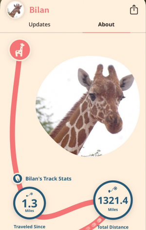 Screenshot of Fahlo app.
Your sense of place starts early. Think about your childhood neighborhood. Scale isn’t important at that age, and concepts of near and far evolve as you grow. When recalling your neighborhood, what locations or landmarks stand out? How do you give directions to a friend–by landmarks or using street names and cardinal directions? Does the address matter, or is it just about finding the destination?
During a recent visit to my local zoo, I noticed a geospatial product available in the gift shop–an elegant bracelet adorned with a carved animal charm that claims to track an individual animal. A friend of mine owns one featuring a giraffe that she monitors. The giraffe, named Bilan, provides daily location updates to support conservation efforts. It is remarkable to observe the extensive distances covered by a single giraffe. Naturally, this made me think, other than your steps via your watch or NORAD keeping a close eye on Santa on December 24th, “How many things are tracked?”
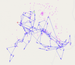 Screenshot of a Moveback map of the Eastern Wild Turkey in Alabama.
For the animal enthusiasts, consider exploring Movebank. They offer a collection of data and map interfaces tailored for tracking animals. This site provides data on various species, such as the northern bald ibis in Africa or the eastern wild turkey in Alabama. Each point, when clicked, displays the movement path of that bird or animal. The collection is replete with research, tracks, and downloadable data. Although the interface is minimalistic and could be improved with enhanced imagery, it effectively allows users to explore information before integrating it into their own projects. There’s much to explore. It’s like Geo-Alice saw a screen that said, “Click me!”
Perhaps space and the stars capture your attention. Check out SkyLive’s planetarium to track where you are compared to the sky above. While not radically new, it does help us connect to spaces and science beyond our visual scope. They also have a ton of other space-based content to explore and track.
Care about trees? Organizations like Veritree, Greenstand, Trees That Feed and others are helping to plant trees globally by partnering with businesses and individuals. Veritree is using some of our favorite geospatial technology (LiDAR, satellite imagery, and drone data) to track progress and share that data on dashboards. Like many great ideas, they share how a cool idea to connect clothing and planting trees led to their work today.
Feeling grounded and connected to a place gives us some significance, maybe even comfort. This might explain the shame linked to homelessness, the unease of being between homes, or living out of a suitcase. There’s no place like home.
The environments we create and curate within our homes reflect our identities and values. They become an extension of who we are, a canvas where our tastes, passions, and histories are displayed. The shared experiences within its walls and beyond weave a tapestry of connection and community, enriching our lives in immeasurable ways.
Ultimately, the true value of a home lies not in its size or its grandeur, but in the love and care that fill its spaces. It is the feeling of being welcomed and cherished, of having a refuge from the outside world where we can be our most authentic selves. In this sense, a happy home is more than just a place–it’s a state of being, an essential ingredient for a fulfilling and balanced life.
If you need me, I’ll be at the firepit enjoying some marshmallows, gazing into the night sky, and contemplating, “How many more trees I can plant in the yard without my husband noticing?” It’s for a good cause!
Barbaree Duke
Geospatial Crusader
In March, we looked at historic Rikers Island in New York. This month for the Pléiades 1–Pléiades Neo Point of Interest, we travel to other side of the world to check out Tofo Beach in Mozambique.
About the Point of Interest: Tofo is a small town in southeastern Mozambique. The town lies on the Indian Ocean coast, on the Barra Beach peninsula in the Inhambane Province. It’s best known for its long, sandy beach with clear, turquois-colored water. The town is surrounded by lush vegetation, including palm trees and mangroves, and boasts natural beauty and wildlife, including dolphins, whales, and sea turtles. The region also features several coral reefs and is popular among divers and snorkelers. Tofo is a popular tourist destination, attracting visitors from around the world to experience its unique geography and marine life.
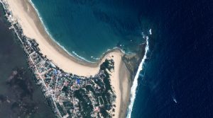
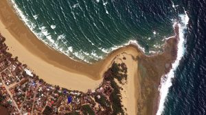 These two satellite images show Tofo Beach from above. In the November 11, 2023, Pléiades 1A 50-cm color photo we gaze down at Tofo Beach with its dazzling tan, sandy beach buffered by a dazzling emerald green body of water that stretches out to a rich, dark blue. We can see waves rippling across the water, the white caps, and a boat zooming across. The second photo captured September 15, 2023, a Pléiades Neo 3 30-cm color photo, also shows an aerial view of the beach in a deeper, richer saturation that also makes the rooves of the buildings pop with color. These images have custom processing and color balancing applied by Apollo Mapping. PLEIADES © CNES 2025, Distribution Airbus DS.
Fun Factoids: (1) There are 25 restaurants within 3 miles of the beach. (2) Summer months are from October to March, with average daily temperatures of 30°C and a relative humidity of 80%. Rains are expected from late December through to February, but these are mostly tropical showers that last only part of the day. (3) Winter months are from April to September, with daily temperatures between 20 and 25°C, and low humidity. In June and July there can be occasional rainfall. (4) Humpback whales usually arrive around mid-June and stay until mid-October. Whale sharks and manta rays are at Tofo all year round. (5) Protected from the elements, the sheltered area inside the bay has gentle waves safe for intermediate surfers and for those who have never surfed before. More advanced surfers who are up for a challenge can tackle the larger swells and the reef break that is a short walk along the beach from Tofo.
The 50-cm Pléiades 1 High-Resolution Satellite Constellation
The Pléiades 1 constellation (or at least part of it!) has been in orbit since December 2011 and if you have not had a chance to check out any sample imagery, take a few moments and have a look at the gallery on our website. If you work with high-resolution imagery, you should consider Pléiades 1 and Pléiades Neo for your next geospatial projects.
A variety of Pléiades 1 products are available from both a well-established archive and as a new collection, including 50-centimeter (cm) pansharpened imagery and 50-cm panchromatic–2-meter (m) 4-band multispectral bundles. We are happy to discuss the technical specifications, pricing and tasking options available with both of these satellite constellations.
The 30-cm Pléiades Neo High-Resolution Satellite Constellation
Pléiades Neo is our newest high-resolution satellite constellation. The first Neo satellite went up in April 2021 and the second in August of the same year. This 30-centimeter resolution constellation will add two more satellites in the next few months and upgrade from daily to intraday revisits. Pléiades Neo has six multispectral bands with 1.2-meter resolution, including a deep blue and two infrared bands, along with a 30-centimeter resolution panchromatic band.
The archive is growing every day, and the satellites are available for new collections, making Pléiades Neo the perfect solution for site monitoring. Check out our beautiful sample images in the Pléiades Neo gallery.
More sample images and technical information about Pléiades 1 can be found on our website here; while the same can be found here for the Pléiades Neo constellation.
The Apollo Mapping sales team can answer any questions you might have about Pléiades 1 and/or Pléiades Neo. We can be reached at (303) 993-3863 or sales@apollomapping.com.
If you are searching for medium and high-resolution satellite imagery, the search is over as Image Hunter is the solution you’ve been looking for! Featuring satellite and aerial imagery as well as digital elevation models (DEMs) from a constantly expanding list of 60+ constellations/datasets and 19 vendors, our database contains more than 200-million images/records meaning there is just no other website out there with this breadth of commercial data products. Our interface is slim-lined and modern, loading quickly on all platforms, browsers and operating systems. Further, our database is updated multiple times an hour with the most recent images collected by WorldView-3, Pléiades 1, PlanetScope, SuperView-1 and many more so you are sure to get the most current view of all the imagery and DEM databases we work with. Once you submit your request, an Apollo Mapping representative will be in touch within 4 Colorado business hours to get you the pricing information you need for your project.
So why wait? Give Image Hunter a try now to find the imagery and/or DEM data you need for your next mapping project!
Key Improvement(s) From The Past Month
We are excited to announce that we added even more data to Image Hunter in the past month–this time it was 30-cm 8-band WorldView Legion 4, which collects more than 500,000 sq km of high-resolution satellite imagery daily! We have another high-resolution satellite cued up for Image Hunter and it is likely to be added in the next few weeks, can you guess what we are adding in? In the past month, we also blocked multiple bot attacks as well as improved the stability of queries for 3-m PlanetScope data.
Here is a summary of the changes/improvements we made to Image Hunter during the past month:
- Added in 30-cm 8-band WorldView Legion 4, our third Legion satellite in the six-satellite constellation.
- Six 50-cm Jilin-1 satellites were launched recently and they are live in Image Hunter now too!
- Applied multiple improvements and fixes to persistent URLs.
- Updated a few backend code bases and security features.
- The date of collection was not displayed on a mobile device for SuperView satellites, now they are.
- PlanetScope searches failed to load more than 2000 results, we fixed that.
- We were attacked multiple times this month by a series of unique bots, we blocked them all.
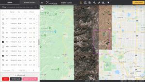
Data Alert–An Automated Daily Imagery Search
Have you checked out Data Alert which lets you define an area of interest anywhere around the globe, the resolution your project requires and the number of months we should keep the alert active? Once an alert is set up, we check for new data over your area of interest every single day, and send you an email when we find coverage that meets your specifications. We have a short YouTube video with directions to set up a Data Alert, check out the last video; and we have written directions for Data Alert here.
The Sensors Available in Image Hunter
As you might have seen in past articles, we now feature hourly updates (seriously!) of GeoEye-1, KOMPSAT 3/3A, Pléiades 1 and Neo, SPOT 6/7, SuperView-1/2/Neo, WorldView-1/2/3/Legion!
Image Hunter can be accessed 24 hours a day, 7 days a week and is a one-stop shop for every major source of medium and high-resolution satellite (and aerial!) imagery on the market today, including:
- WorldView Legion
- WorldView-4
- WorldView-3
- WorldView-2
- WorldView-1
- QuickBird
- GeoEye-1
- IKONOS
- EROS B
- KOMPSAT-3A
- KOMPSAT-3
- KOMPSAT-2
- Pléiades 1 constellation
- Pléiades Neo constellation
- TerraSAR-X (TerraSAR-X, TanDEM-X and PAZ)
- GEOSAT-1
- GEOSAT-2
- TripleSat
- BJ3A
- BJ3N
- SPOT 1 to 7 constellation
- RapidEye
- GaoFen-2
- GaoFen-1
- ZiYuan-3 01/02 (mono and stereo!)
- FORMOSAT-5
- FORMOSAT-2
- ALOS PRISM (stereo)
- AW3D Standard (DEM)
- SkySat constellation
- PlanetScope constellation (including 5-band SuperDove data)
- SuperView-1 constellation
- SuperView-2
- SuperView Neo-1 01/02
- SuperView Neo-3
- Landsat 1-8
- TeLEOS-1
- Hexagon (HxGN Content Program aerial imagery) imagery + DEM
- WorldDEM
- WorldDEM Neo
- Vricon DEMs
- Orbita Hyperspectral Satellite (OHS)
- KazEOSat-1
- KazEOSat-2
- Jilin-1 Optical
- Jilin-1 Video (including nighttime imagery)
- Jilin-1 GF/DP
- Jillin-1 KF
- Orbita Video Satellites-1/2/3 (OVS-1/2/3)
- BlackSky Global series
Key Features of Image Hunter
If any of our readers have struggled with other geospatial search engines that are clunky, only query one data source and/or do not provide image previews, then Image Hunter is the solution to your woes as it features:
- Online browsing of satellite and aerial imagery from 19 data providers and 56 satellite and aerial imagery derived datasets.
- Near-instantaneous loading of low-resolution preview imagery with collection date, cloud cover and other key metadata.
- The ability to define your area of interest by address, coordinates, geometric shape or shapefile/KMZ.
- A responsive basemap with street names to provide spatial context when discovering data as well as crowd-sourced updates for the most accurate map possible.
- Exports of the area of interest you create as well as the scenes you select in shapefile or KMZ format.
- Support for all operating systems, and not just our friends with Windows machines!
Image Hunter can be accessed here all day and night, we are excited to find out what you think about our imagery search engine! So if you have any ideas and/or feedback to improve Image Hunter, please let us know at sales@apollomapping.com or (303) 993-3863.
¡Bienvenidos a abril! Nosotros en Apollo Mapping estamos gustosos de tenerlos otro mes aquí en los resúmenes españoles del mes de abril.
50 cm 8-Band SuperView Neo-3 Añadido a Cazador de Imágenes
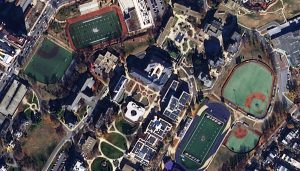 Imagen en color de 50 cm de SuperView Neo-3 capturada sobre Washington, DC, el 12 de diciembre de 2024.
¡Nos complace anunciar que nuestra más reciente imagen satelital de alta resolución está disponible en Cazador de Imágenes, se trata de SuperView Neo-3, un satélite de 50 centímetros (cm) y 8 bandas, parte de la constelación SuperView Neo. Neo-3 se diferencia de sus satélites gemelos, Neo-1 01/02, por sus imágenes multiespectrales de 2 metros (m) y 8 bandas, además de una huella de imagen líder en la industria de 130 kilómetros (km) de ancho. SuperView Neo-3 también captura imágenes con una inclinación de 10° o menos fuera del nadir, lo que reduce la inclinación en los datos. Esto es crucial en áreas con edificios altos, árboles y montañas, así como en regiones con pasajes estrechos y profundos. Gracias a su enorme huella de 130 km de ancho, Neo-3 puede recolectar hasta 1.4 millones de km² de datos de 50 cm y 8 bandas diariamente.
Especificaciones clave de SuperView Neo-3 que lo apartan del competidor:
- Resolución de 50 cm en pancromático y 2 m en 8 bandas multiespectrales, incluyendo azul, verde, rojo e infrarrojo cercano (NIR), además de azul costero, amarillo, borde rojo y NIR2.
- Imágenes capturadas con una inclinación de 10° o menos.
- Huella de imagen de 130 km de ancho.
- Capacidad de recolección de 1.4 millones de km² por día.
Si deseas llevar tu análisis espectral al siguiente nivel, SuperView Neo-3 de 50 cm y 8 bandas será una de tus mejores opciones.
Puedes consultar SuperView Neo-3 en Cazador de Imágenes en cualquier momento. Si tienes preguntas sobre cómo utilizar SuperView Neo-3 para tu próximo proyecto de mapeo, contáctanos en sales@apollomapping.com.
Colecciones de Imágenes de Alta Resolución–WorldView-2/3–Canadá y Estados Unidos, Junio a Agosto de 2024
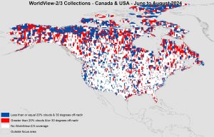 Este mapa muestra las áreas capturadas por la constelación WorldView-2/3 entre el 1 de junio y el 31 de agosto de 2024 sobre las principales masas terrestres de Canadá y Estados Unidos. Cabe destacar que, en muchos casos, se recopilaron múltiples imágenes sobre la misma zona, lo que puede ser difícil de visualizar en este mapa estático.
En esta publicación mensual, ofrecemos a nuestros lectores una visión general de la cobertura de imágenes de alta resolución recopiladas sobre una región específica durante un período determinado. Para ello, seleccionamos una constelación de satélites de alta resolución, un período de tiempo definido y un área de interés, y luego informamos estadísticas clave sobre la cantidad total de imágenes recopiladas en kilómetros cuadrados (km²). Sin más preámbulos, pasemos al análisis.
Región Gráfica de Interés: Canadá y Estados Unidos (solo las masas terrestres principales)
Superficie Terrestre Cubierta: 18,982,175.9 km²
Período de Tiempo: 1 de junio–31 de agosto de 2024
Constelación de Satélites de Alta Resolución: WorldView-⅔
Estadísticas de Imágenes–Constelación WorldView-2/3 (Canadá + EE. UU.)
Área total recopilada: 19,863,436.1 km² (107,953.5 km² por satélite/día)
Área recopilada con menos del 20% de nubosidad y una inclinación de 30° o menos fuera del nadir: 6,165,006.9 km² (33,505.5 km² por satélite/día; 31.04% del total)
Producto Destacado–Monitoreo de Sitios con Descuento con Pléiades Neo de 30 cm
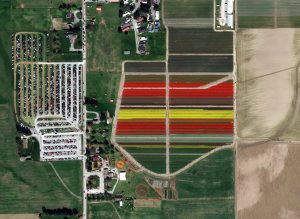 Una imagen en color de 30 cm de Pléiades Neo tomada el 28 de abril de 2023 sobre Roozengaarde en el Valle de Skagit, Washington, EE. UU., durante el Festival Anual de los Tulipanes.
En el mundo en constante evolución de la tecnología geoespacial, Airbus ofrece una solución revolucionaria para la recopilación repetida de imágenes. Pléiades Neo OnePlan de Airbus es una potente solución de monitoreo que combina innovación de vanguardia con una capacidad de recolección sin precedentes a una resolución de 30 centímetros (cm).
Con Pléiades Neo de 30 cm, los clientes de Apollo Mapping pueden monitorear el crecimiento urbano, rastrear cambios ambientales y obtener información valiosa sobre el desarrollo de infraestructuras con una resolución y recolección repetida sin precedentes. Sus capacidades de última generación garantizan la entrega oportuna de datos, permitiendo la toma de decisiones informadas como nunca antes. Airbus tiene un historial exitoso en la recopilación rápida de imágenes de alta calidad, lo que la convierte en la mejor opción para aplicaciones de monitoreo.
La solución de programación Pléiades Neo OnePlan tiene una estructura de precios flexible, ofreciendo un costo por kilómetro cuadrado con descuento que la convierte en una opción fantástica para una amplia gama de aplicaciones.
Pléiades Neo de Airbus también cuenta con un impresionante tiempo de entrega estándar de 12 horas o menos una vez que las imágenes son recopiladas y transmitidas, asegurando que tengas acceso a los datos más recientes cuando más los necesites. Desbloquea un mundo de posibilidades en monitoreo, análisis y toma de decisiones con Pléiades Neo OnePlan de 30 cm de resolución.
Para obtener más información sobre la programación de Pléiades Neo OnePlan de 30 cm para el monitoreo de sitios, envíanos un correo electrónico en cualquier momento a sales@apollomapping.com y te responderemos de inmediato.
Fernando Gutierrez
Topographic Translator
We are on a roll recently as we just added in our second, new high-resolution satellite imagery dataset to Image Hunter! It is the third WorldView Legion satellite, Legion 4, which collects 30-centimeter (cm) 8-band data. Imaging some 525,000 square kilometers (sq km) of 30-cm data daily, WorldView Legion 4 is the first mid-latitude orbit (MIO) satellite that is operational in the WorldView Legion constellation. MIO satellites are in a persistent orbit between 45° North and South latitudes, allowing them to image locations where the vast majority of the human population lives multiple times a day.
 A 30-cm color WorldView Legion sample collected over the Thomas Jefferson Memorial in Washington D.C., USA on October 19, 2024. (Image courtesy Maxar)
Legion 4 is the third active satellite in the WorldView Legion constellation which sets itself apart with these unique specifications:
- 6 satellite constellation with 4 MIO satellites.
- 30-cm panchromatic band plus 1.2-meter (m) 8-band multispectral including coastal, blue, green, yellow, red, red edge 1, red edge 2, and near-infrared (NIR).
- Each satellite in the constellation images over 500,000 sq km per day.
- When all 6 WorldView Legion satellites are live, the constellation will average 3 accesses per day to locations between 40° North and South latitudes.
- With 4 MIO satellites, WorldView Legion will image throughout the day, not just during the morning as most satellite systems do.
This valuable 8-band 30-cm dataset is quickly filling the high-resolution archives of Image Hunter–so get your search started now! And if you have any questions about using WorldView Legion in your next mapping project, send us an email now to sales@apollomapping.com.
This map shows the areas imaged by the WorldView-2/3 constellation from June 1 to August 31, 2024 over the primary land masses of Canada and the United States. Please note that in many instances, multiple images were collected over the same area which is difficult to portray on this static map.In this monthly piece, we give our readers a sense of the high-resolution imagery coverage collected over a geography during a specified window. To do this, we pick a high-resolution satellite constellation, a defined time period and area of interest, then report key statistics on the total amount of imagery collected in square kilometers (sq km). Without further delay, let’s jump into our analysis.
Graphic Region of Interest: Canada and the United States (USA), primary land masses only
Land Mass Covered: 18,982,175.9 sq km
Time Period: June 1 to August 31, 2024
High-Resolution Satellite Constellation: WorldView-2/3
WorldView-2/3 Constellation Imaging Statistics–Canada + USA
Total Area Collected: 19,863,436.1 sq km; 107,953.5 sq km per satellite/per day
Area Collected @ 20% or Less Clouds & 30 Degrees or Less Off-Nadir: 6,165,006.9 sq km; 33,505.5 sq km per satellite/per day; 31.04% of total