


We love maps.
We love imagery.
We love work breaks.
We hope you like them as well!
In 1986, Larry Harvey and his friend, Jerry James, pieced together a wooden figure and dragged it down to Baker Beach for the summer solstice where it burned, surrounded by a group of onlookers. Now an annual event, the 2025 festival has a new theme with organizers working behind the scenes leading up to the big event. In fact, we’ve written about Burning Man in the past, as it’s quite intriguing.
This year, there will be a Gateway Burn in St. Louis, the Cosmic Cabaret in New York, and the Freezer Burn in Alberta, Canada. The Gateway Burn is an annual event that celebrates the Gateway Burners community. In the spirit of Burning Man, attendees gather and camp together for four days of art, creativity, music, workshops, community activities, education, etc.; and then they end the weekend with an effigy burn. Cosmic Burn is a multi-day campout event while Freezer Burn is the annual Alberta Regional Burning Man celebration where organizers create a temporary community out on the prairie to replicate the Burning Man experience.
For this month’s Imagery Work Break, we have a 30-centimeter Pleiades Neo 4 image collected on August 25, 2024, looking down on Black Rock City, Nevada, at the jampacked 2024 Burning Man Festival. The event draws as many as 70,000 people each year. The 2025 festival will be August 24th to September 1, with the theme: Burning Man 2025: Tomorrow Today.
Have a great rest of your workday! 😊
(Image Courtesy: Airbus. Processed by Apollo Mapping for improved grey-scale accuracy and clarity.)
¡Bienvenidos a septiembre! Nosotros en Apollo Mapping estamos gustosos de tenerlos otro mes aquí en los resúmenes españoles del mes de septiembre.
Constelación WorldView Legion de 30 cm y 8 bandas ¡Ya en vivo en Cazador de Imágenes!
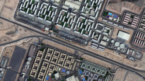 Imagen de 30 cm de WorldView Legion cortesía de Maxar, tomada sobre el Campus NEOM en Arabia Saudita el 2 de diciembre de 2024. Apollo Mapping ha aplicado un balance de color personalizado y mejoras en la imagen.
Estamos muy emocionados de anunciar que los dos últimos satélites de la constelación WorldView Legion de 30 centímetros (cm) y 8 bandas ya están activos, ¡damos la bienvenida a Legion 5 y Legion 6 en Cazador de Imágenes! Con seis satélites de 30 cm en órbita, esta constelación agrega 3.2 millones de kilómetros cuadrados de imágenes satelitales de alta resolución a Cazador de Imágenes todos los días, ¡impresionante! Además, con imágenes multiespectrales de 8 bandas líderes en la industria, WorldView Legion está listo para abordar tu próximo proyecto geoespacial, incluso si el análisis espectral es lo que necesitas.
Con seis satélites activos en órbita, la constelación WorldView Legion se distingue con estas especificaciones únicas:
- Una constelación de seis satélites con cuatro satélites en órbita media (MIO).
- Banda pancromática de 30 cm más multiespectral de 8 bandas a 1.2 metros (m), incluyendo: costera, azul, verde, amarillo, rojo, borde rojo 1, borde rojo 2 e infrarrojo cercano (NIR).
- Cada satélite de la constelación captura más de 500,000 km² por día.
- La constelación WorldView Legion promedia 3 accesos por día a ubicaciones entre las latitudes 40° Norte y Sur.
- Con cuatro satélites MIO, WorldView Legion captura imágenes a lo largo del día, no solo por la mañana como lo hacen la mayoría de los sistemas satelitales.
Si deseas obtener más información sobre cómo utilizar WorldView Legion de 30 cm para tu próximo proyecto de cartografía y/o teledetección, puedes enviarnos un correo electrónico en cualquier momento a sales@apollomapping.com.
O también puedes consultar todo el archivo de WorldView Legion de 30 cm en cualquier momento en Cazador de Imágenes.
Colecciones de Imágenes de Alta Resolución–Pléiades 1–Medio Oriente, marzo a mayo de 2025
 Este mapa muestra las áreas capturadas por la constelación Pléiades 1 entre el 1 de marzo y el 31 de mayo de 2025 sobre el Medio Oriente. Ten en cuenta que, en muchos casos, se recopilaron múltiples imágenes sobre la misma área, lo cual es difícil de representar en este mapa estático.
En esta publicación mensual, damos a nuestros lectores una idea de la cobertura de imágenes de alta resolución recopilada sobre una geografía durante un período de tiempo específico. Para hacerlo, seleccionamos una constelación de satélites de alta resolución, un período de tiempo definido y un área de interés, luego informamos estadísticas clave sobre la cantidad total de imágenes recopiladas en kilómetros cuadrados (km²). Sin más demora, pasemos a nuestro análisis.
Región Gráfica de Interés: Medio Oriente
Superficie Terrestre Cubierta: 6,674,329.3 km²
Período de Tiempo: del 1 de marzo al 31 de mayo de 2025
Constelación de Satélites de Alta Resolución: Pléiades 1A/1B
Estadísticas de Imágenes de la Constelación Pléiades 1–Medio Oriente
Área Total Recolectada: 2,242,426.6 km²; 12,187.1 km² por satélite/por día
Área recolectada con 20% o menos de nubes y 30 grados o menos de inclinación: 1,875,041.7 km²; 10,190.4 km² por satélite/por día; 83.6% del total (¡WOW!).
Tu Pausa de Imágenes–Burning Man 2024
Nos encantan los mapas.
Nos encantan las imágenes.
Nos encantan las pausas en el trabajo.
¡Esperamos que a ti también te gusten!
En 1986, Larry Harvey y su amigo Jerry James construyeron una figura de madera y la llevaron a Baker Beach para el solsticio de verano, donde la quemaron rodeados por un grupo de espectadores. Ahora convertido en un evento anual, el festival de 2025 tiene un nuevo tema con organizadores trabajando entre bastidores de cara al gran evento. De hecho, hemos escrito sobre Burning Man en el pasado, ya que resulta bastante intrigante.
Este año habrá un Gateway Burn en San Luis, el Cosmic Cabaret en Nueva York y el Freezer Burn en Alberta, Canadá. Gateway Burn es un evento anual que celebra a la comunidad Gateway Burners. Siguiendo el espíritu de Burning Man, los asistentes se reúnen y acampan durante cuatro días de arte, creatividad, música, talleres, actividades comunitarias, educación, etc.; y luego terminan el fin de semana con la quema de una efigie. Cosmic Burn es un evento de campamento de varios días. Freezer Burn es la celebración regional anual de Burning Man en Alberta, donde los organizadores crean una comunidad temporal en las praderas para replicar la experiencia de Burning Man.
Para la Pausa de Imágenes de este mes, tenemos una imagen de 30 centímetros de Pléiades Neo 4, recopilada el 25 de agosto de 2024, que muestra desde arriba Black Rock City, Nevada, en el abarrotado Festival Burning Man 2024. El evento atrae a hasta 70,000 personas cada año. El festival de 2025 se celebrará del 24 de agosto al 1 de septiembre, con el tema: Burning Man 2025: Mañana Hoy
¡Que tengas un excelente resto de tu jornada laboral!
(Imagen cortesía de Airbus. Procesada por Apollo Mapping para mejorar la precisión y claridad en escala de grises.)
Fernando Gutierrez
Topographic Translator
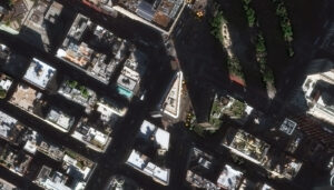
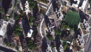 The Flatiron Building was one of the earliest skyscrapers built in New York–1902 to be exact. It stands tall at the corner of Fifth Avenue and 23rd Street on a triangle-shaped piece of land, and originally was named the Fuller Building after the company that built it. But that name didn’t stick, because people thought the 22-stories-tall building, which was huge for 1902, resembled an iron one would press clothes with, hence its new name was born, the Flatiron Building. The Flatiron Building might look familiar to you. It’s appeared in such movies as Godzilla and Spider-Man. It used to have only one staircase but a remodel installed more. The building also used six elevator cabs with a hydraulic system, but they were remodeled in the late 1980s to become fully electric. It’s also one of the key buildings in the Beaux-Arts Classicist movement. Among its most notable details is the reinterpretation of classical Greek columns. Like predecessors, the façade is divided into a base, shaft, and capital. The building is clad in glazed terra-cotta and limestone, with plenty of Beaux Arts decorative elements such as oriel windows, cornices, and moldings that reward a closer look. The Flatiron Building was one of the first in NYC to use a full steel skeleton for its construction. The designers also added extra bracing by using diagonal steel bars inside the frame in order to keep it steady in the wind. For most of its life, the Flatiron Building housed offices with the likes of publishers and architects renting space. Today, the building is called home by numerous people who live there in luxury condos. In the images featured here, we can see the rooftops of many buildings, including the Flatiron Building stretching high. This 30-cm WorldView Legion image was collected on October 19, 2024, and has custom processing and color balance applied by Apollo Mapping. (Satellite Imagery © 2025 Maxar Technologies)
In this monthly article, we travel the world to check out unique, fun and sometimes a bit weird 30-centimeter (cm) color imagery samples from the WorldView constellation. In August, we looked at an image of Stadium 974 in Doha, Qatar. For this edition of the 30-cm Color WorldView Image of the Month, we feature images of two well-known skyscrapers just in time for National Skyscraper Day on September 3rd.
30-cm WorldView-3 (WV3) launched in late 2014, WorldView-4 (WV4) launched in late 2016 and then the first WorldView Legion satellites launched in 2024. Taken together, this is the most advanced satellite constellation the commercial marketplace has ever had access to. Here are a few of the features that really set these satellites apart from the competition:
- Improved Resolution
- Higher resolution means you can see more detail in WorldView imagery.
- Data collected at nadir will have 31-centimeter (cm) panchromatic, 1.24-meter (m) visible and near infrared, 3.7-m SWIR (WV3 only) and 30-m CAVIS (WV3 only) bands.
- Additional Spectral Bands
- If spectral analysis is part of your project, then no other satellite can match WorldView-3 and WorldView Legion with their 8 bands of visible and near-infrared data; and then 8 shortwave infrared bands (WV3 only) which are crucial for geological studies.
- Better Positional Accuracy
- With accuracies of 3.5-m CE90% or better (without ground control even!), the 30-cm WorldView constellation has no rivals for its enhanced positional accuracy.
- Daily Revisits
- With multiple WorldView-3 and WorldView Legion satellites orbiting our planet, daily revisits are available for most locations.
- WV4 is no longer collecting new imagery.
- Increased Collection Capacity
- WV3/4 feature 13.1-km swath widths (at nadir) with the ability to collect up to 680,000 square kilometers (sq km) of high-resolution data per day per satellite (though WV4 is dead now).
- WorldView Legion features six 30-cm satellites, significantly boosting the collection capacity of this leading high-resolution constellation.
If you are interested in WorldView-3, WorldView-4 and/or WorldView Legion imagery for your next project, please let us know by phone, 303-993-3863, or by email, sales@apollomapping.com.
You can also find more WV3 samples and technical information on our website here; WV4 samples and information can be found here; and then finally here is more information about WorldView Legion.
In August, we looked at Hersheypark, Pennsylvania, in honor of National Chocolate Chip Cookie Day. This month for the Pléiades 1–Pléiades Neo Point of Interest, we check out Pyongyang’s Mirae Scientists Street in North Korea.

 These two satellite images show the Mirae Scientists Future Street from above. The Pléiades 1B 50-cm color image from June 3, 2022, shows the vividly covered buildings from above, their varying heights and the maze-like appearance of the neighborhood. In the second photo, a Pléiades Neo 4 30-cm image captured September 7, 2022, we can see the more vibrant colors the neighborhood exhibits as viewed from above. These images have custom processing and color balancing applied by Apollo Mapping. PLEIADES © CNES 2025, Distribution Airbus DS.
About the Point of Interest: Mirae Scientists Street (Future Scientists Street) is a street in Pyongyang, North Korea. It houses scientific institutions of the Kim Chaek University of Technology and their employees. The six-lane street, located between Pyongyang Railway station and the Taedong river, is lined by high rise apartments. The area officially opened November 3, 2015. The tallest building is the 53-story blue Mirae Unha Tower. Mirae Scientists Street was reportedly the first location where the Mirae public WiFi network was installed.
Fun Factoids: (1) Construction of Mirae Scientists Future Street started in 2014 and the street was inaugurated in 2015, built at was has been dubbed “Pyongyang Speed.” Slogans referring to speed where first used in North Korea in the 1950s after the DPRK was rebuilt from scratch following the Korean War. (2) It consists of a 6-lane street with skyscrapers, cultural facilities such as an e-library and cinema, stores, bars and restaurants, including an Italian food restaurant. Mirae Street also boasts a nursery, kindergarten, primary school and middle school. (3) The apartments mainly house teachers and scientists from Kim Chaek University of Technology. This university is home to over 2,000 staff members and 15,000 students and 40 undergraduate degrees. The university also runs distant education programs with 24,000 enrolled students. Faculties include mechanical engineering, physical engineering, applied chemical engineering and electronics; and the university has been awarded several international prizes. (4) The most iconic building of Mirae Street is the 53-story Unha Tower. Galaxy Tower, shaped as a stretched atom, dwarfs anything surrounding it as it rises 150-meters high up into the skies of Pyongyang. (5) The Mirae overpass at one end of the street is the best spot to take pictures of the street itself. The overpass has a tower with an atom at the top, a recurring theme in Mirae Street.
The 50-cm Pléiades 1 High-Resolution Satellite Constellation
The Pléiades 1 constellation (or at least part of it!) has been in orbit since December 2011 and if you have not had a chance to check out any sample imagery, take a few moments and have a look at the gallery on our website. If you work with high-resolution imagery, you should consider Pléiades 1 and Pléiades Neo for your next geospatial projects.
A variety of Pléiades 1 products are available from both a well-established archive and as a new collection, including 50-centimeter (cm) pansharpened imagery and 50-cm panchromatic–2-meter (m) 4-band multispectral bundles. We are happy to discuss the technical specifications, pricing and tasking options available with both of these satellite constellations.
The 30-cm Pléiades Neo High-Resolution Satellite Constellation
Pléiades Neo is our newest high-resolution satellite constellation. The first Neo satellite went up in April 2021 and the second in August of the same year. This 30-centimeter resolution constellation will add two more satellites in the next few months and upgrade from daily to intraday revisits. Pléiades Neo has six multispectral bands with 1.2-meter resolution, including a deep blue and two infrared bands, along with a 30-centimeter resolution panchromatic band.
The archive is growing every day, and the satellites are available for new collections, making Pléiades Neo the perfect solution for site monitoring. Check out our beautiful sample images in the Pléiades Neo gallery.
More sample images and technical information about Pléiades 1 can be found on our website here; while the same can be found here for the Pléiades Neo constellation.
The Apollo Mapping sales team can answer any questions you might have about Pléiades 1 and/or Pléiades Neo. We can be reached at (303) 993-3863 or sales@apollomapping.com.
This map shows the areas imaged by the Pléiades 1 constellation from March 1 to May 31, 2025 over the Middle East. Please note that in many instances, multiple images were collected over the same area which is difficult to portray on this static map.In this monthly piece, we give our readers a sense of the high-resolution imagery coverage collected over a geography during a specified window. To do this, we pick a high-resolution satellite constellation, a defined time period and area of interest, then report key statistics on the total amount of imagery collected in square kilometers (sq km). Without further delay, let’s jump into our analysis.
Graphic Region of Interest: Middle East
Land Mass Covered: 6,674,329.3 sq km
Time Period: March 1 to May 31, 2025
High-Resolution Satellite Constellation: Pléiades 1A/1B
Pléiades 1 Constellation Imaging Statistics–Middle East
Total Area Collected: 2,242,426.6 sq km; 12,187.1 sq km per satellite/per day
Area Collected @ 20% or Less Clouds & 30 Degrees or Less Off-Nadir: 1,875,041.7 sq km; 10,190.4 sq km per satellite/per day; 83.6% of total (WOW!!)
A couple of columns ago I wrote about the “beautiful dancing girl” who I met at a Phish show years ago. Well, after a great month of hanging out together, I left on my extended travels (to be about four months), and we arranged for her to come visit a little less than two months into my trip in early August. We maintained frequent, daily contact, texting often, and talking on the phone a couple times a week. We talked about how we missed one another and how we looked forward to her visit. We even discussed her coming out a second time before I returned home, too. I was excited about her and the potential for the future. All was well. Until it wasn’t.
As mentioned, she’s a huge Phish fan, and she’d made plans to see the band three separate weekends between early July and early September. In fact, she had a lot of travel plans for the summer. First, she went to her grandma’s place in Cincinnati with her mom, dad, and dog; the following weekend she went to the mountains to see her cousin for the 4th of July, and then she had the first Phish weekend in Charleston, SC, the weekend after. On both of those first two trips she was very active in her communication with me, and I had no reason to think anything had changed–and as far as I can tell, at the time, neither did she; everything was going well. Then came Phish.
 It was over before it could ever get off the ground, sadly… (Image retrieved from here and comes courtesy of Vera Arsic.)
A little background: she used to be a party girl, and she has been pretty open about her tendency to develop crushes on “red flag” type of guys, many of whom you can find by the dozen at Phish shows. She’s had a number of trysts with them over the years since we first met, and they all sputtered out or flamed out, but they were looney messes all the while, best I can tell. That is until she met the guy she dated for about three years before me which seemed like a “normal” stable relationship with its fair share of issues and frustrations–but all relationships have some of those. Anyway, when we started hanging out, she told me that the reason she’d never dated me before was because I “had my shit together.” I was “too responsible,” but she had changed, as had her taste in men. Or so she said.
Back to Phish Weekend One. She went down a day early for the 3-day run of concerts, and it might’ve been about that day that I had a weird sensation that I couldn’t place. First, I sensed something was askew with her, and paradoxically, I started to miss her more than I had up until that point. I’m not one of those kooky “vibes of the universe” kind of guy, but her communication dropped off precipitously–which was reasonable because she was going on vacation to see her favorite band and hang out with friends she only saw at these shows–but something inside me burned that she’d hooked up with another guy, or at least was thinking about it. Long story short, I wrote an email to her on the Sunday of her festivities (day three of the concerts) basically telling her how I felt about her (no, I didn’t say I loved her) and all that jazz. We spoke briefly on her ride home on Monday (today, the day I’m writing this) and I could tell it was off. She said she hadn’t read my email yet. We told one another we missed the other, but I didn’t really believe her when she said it.
Fast-forward a couple hours and I’m at a car detailing place getting some work done on my car and she calls me, still on the road home, indicating she’d read my email when she stopped for lunch and that it was “super sweet” but made her “feel anxious.” Perhaps I’d overplayed my hand (and yes, I thought about including the text of it here, but it’s a little too embarrassing this early in my postmortem assessment of where things went off the rails). We talked for a little while, and she started downplaying things she’d said and ways she’d behaved, and if I wasn’t so anti-pop culture language, I’d be tempted to say she engaged in a bit of gaslighting (ugh, it pains me to type that). I tried to cycle through all of what she’d conveyed to me just in recent weeks since I hit the road and it didn’t add up. In the interim, she was supposed to have a weekend off from travel this upcoming weekend, but she’d booked a flight and made plans to go see Phish in Chicago. Yeah, I’m pretty sure she’s got another guy… I asked her if she still wanted to keep her plans to visit me, and she didn’t offer up an entirely comforting answer–basically a mixture of yes/no/I don’t know. After Chicago she goes to NY to see the band. I told her I was going to give her space until after that and if she wanted to contact me, I would love that, but I’m not going to bother her until then. My guess is her visit to me will be canceled and with it whatever I thought/hoped might happen in the future.
The moral of the story at this early juncture–before I’ve even had time to process it at all–is that when someone shows you who they are, believe them. My criticisms of her when we were occasional friends were that she was flighty, aloof, and sometimes came off as rude and dismissive, and certainly evidenced a lot of signs of being a hot mess. Still, I gave her some benefit of the doubt–yes, in part because she’s hot–but also because I didn’t want to rush to any conclusions. There was also something appealing about her beyond her physical beauty. But it seems that maybe I should’ve trusted my gut.
I hate dating. I hate that I’m going to do it again. I hate that I’ll encounter a lot more frustration before I have some fun and connection, probably. But so it goes… I saw this musician this past weekend I’d never seen but wanted to for a while, Ray Wylie Hubbard. He has a line in one of his songs, “Mother Blues,” that goes: “And the days that I keep my gratitude / Higher than my expectations / Ah! Well, I have really good days.”
I guess at this stage I should be thankful for the really awesome month we had together, and even those first three weeks apart when it felt like we were still making progress for the future. It’ll save me a lot of frustration and heartache if I choose to look at it that way. Having too high of expectations really does just end up letting you down all too often…
Marco Esquandoles
Starting Over–Again
Summer is waning and the smell of school supplies looms in the air. I do love a fresh pencil! For me, it’s a signal for fresh ideas and problem solving. I’m reminded of how many ways the geospatial community is using their mapping technology and talents for good.
Geospatial work can have various impacts depending on its application. If “good” is defined as providing benefit to individuals or entities, there are multiple relevant examples. For this discussion, the focus will be on people, places, and initiatives. In April we explored some animal and tree tracking that also were doing good for the world. How many organizations are working for the good?
National Geographic Explorer, Nick Okafor and his organization, Trubel & Co, have invested in training young people, ages 18-25, to map and explore social and environmental justice. Their 2024 class explored issues in Florida such as mental health and heat stress, red tide, incarceration, and climate gentrification. These students are learning to explore data and tell analytical stories to “spark good trouble.”
The Food Empowerment Project believes that your food choices can change the world. According to their website, “Food Empowerment Project seeks to create a more just and sustainable world by recognizing the power of one’s food choices.” Their work extends beyond food into other community needs like school supplies for students and scholarships. The USDA Food Access Research Atlas allow you to preview and download data on access and income.
 Image created in Canva by the Geospatial Crusader.
Getting beyond expected uses of data and maps is important also. The Nature Conservancy and the Lincoln Institute of Land Policy are continuing their good work to protect nature and land. The World Vision Organization is mapping and championing the use of imagery to examine clean water. One of their projects focuses on water, sanitation, and hygiene initiatives. Their interesting use of high-resolution imagery to highlight and solve some of these challenges utilizes other open data sources as well.
If you want to branch beyond just mappy endeavors, AI for Good at Meta, “is helping organizations leverage open source AI models and datasets that help governments improve service delivery, researchers advance scientific innovation, and humanitarian organizations better reach populations in need.” They’re work is part of an ongoing zeal to create a robust community for open-source tools.
Even though the tools may be open, there’s still a need for data care. Data for Good has created a platform infrastructure designed to connect citizens, companies, and public organizations in a digital ecosystem. This system allows data sharing under individual citizen control, supporting the development of new digital services and generating insights.
Humanitarian initiatives globally and across various sectors are making a significant impact. Esri’s Humanitarian Hub has identified several key areas of focus for these efforts. Localisation means working with local organizations and communities to create solutions. Utilizing geodesign to not only prevent hazards, but also anticipate risk is vital to create more sustainable environments. They encourage us to pair those efforts with innovation and the power of geospatial thinking.
Finally, what can you do if you don’t work in one of these areas of the geospatial community? You can volunteer with the GIS Corps! In a recent project with the Food Bank of Central and Eastern North Carolina, “FBCENC sought the assistance of a GISCorps Volunteer with experience in developing aesthetically pleasing and informative ArcGIS Dashboards from Survey123. This project will be in support of the Pop Up Markets program–mobile food distributions led by Food Bank staff to address gaps in food access across the Food Bank’s service area.” Think about it. You might not need to leave your office to do something good!
If you need me, I’ll be volunteering with my local organization to help students. We can make a difference, one person at a time!
Barbaree Duke
Geospatial Crusader

Cricket’s Chirp is created for Apollo Mapping by Ron Ruelle, a Wilmington, NC (formerly Boulder, CO) based cartoonist, lllustrator and teacher. No animals are harmed in the creation of these comics, but Ron sometimes breaks a pencil in frustration. You can see more of his work at www.ronruelle.com