
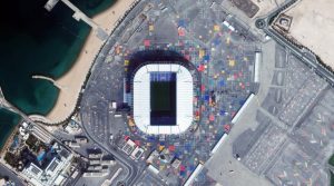
 The 974 Stadium in Doha, Qatar boasts 40,000 seats and is a one-of-a-kind architectural structure made out of 974 shipping containers in an effort to use sustainable materials in its creation. The shipping containers also pays homage to the site’s strategic location, industrial history and the international dialing code for Qatar. The stadium hosted the FIFA 2022 World Cup and was the first planned temporary venue in FIFA World Cup history. The stadium hosted test matches during the 2021 FIFA Arab Cup and was a landmark venue during the 2022 FIFA World Cup. While the stadium was to be dismantled and moved to Africa or South America, and the former site it sat on was to be transformed via a waterfront development, as of February 2025, those plans had not materialized and the stadium currently still sits in place at its original site. Most recently, the venue was used for the 2024 FIFA Intercontinental Cup and the 2024 Trophée des Champions. It was initially committed to go to Maldonado, Uruguay, where it would be used for the 2030 FIFA World Cup; however, the Uruguay–Argentina–Chile–Paraguay bid did not succeed. Other plans were floated to transport 974 Stadium to an African nation, but those did not materialize either. In the WorldView Legion image feature here, we can see 974 Stadium and its colorful shipping container design. This 30-cm Legion image was collected on December 23, 2024, and has custom processing and color balance applied by Apollo Mapping. (Satellite Imagery © 2025 Maxar Technologies)
In this monthly article, we travel the world to check out unique, fun and sometimes a bit weird 30-centimeter (cm) color imagery samples from the WorldView constellation. In July, we looked at stunning imagery from high above the Neom campus in Saudi Arabia. For this edition of the 30-cm Color WorldView Image of the Month, we feature an image of Stadium 974 in Doha, Qatar.
30-cm WorldView-3 (WV3) launched in late 2014, WorldView-4 (WV4) launched in late 2016 and then the first WorldView Legion satellites launched in 2024. Taken together, this is the most advanced satellite constellation the commercial marketplace has ever had access to. Here are a few of the features that really set these satellites apart from the competition:
- Improved Resolution
- Higher resolution means you can see more detail in WorldView imagery.
- Data collected at nadir will have 31-centimeter (cm) panchromatic, 1.24-meter (m) visible and near infrared, 3.7-m SWIR (WV3 only) and 30-m CAVIS (WV3 only) bands.
- Additional Spectral Bands
- If spectral analysis is part of your project, then no other satellite can match WorldView-3 and WorldView Legion with their 8 bands of visible and near-infrared data; and then 8 shortwave infrared bands (WV3 only) which are crucial for geological studies.
- Better Positional Accuracy
- With accuracies of 3.5-m CE90% or better (without ground control even!), the 30-cm WorldView constellation has no rivals for its enhanced positional accuracy.
- Daily Revisits
- With multiple WorldView-3 and WorldView Legion satellites orbiting our planet, daily revisits are available for most locations.
- WV4 is no longer collecting new imagery.
- Increased Collection Capacity
- WV3/4 feature 13.1-km swath widths (at nadir) with the ability to collect up to 680,000 square kilometers (sq km) of high-resolution data per day per satellite (though WV4 is dead now).
- When fully launched, WorldView Legion will feature six 30-cm satellites, significantly boosting the collection capacity of this leading high-resolution constellation.
If you are interested in WorldView-3, WorldView-4 and/or WorldView Legion imagery for your next project, please let us know by phone, 303-993-3863, or by email, sales@apollomapping.com.
You can also find more WV3 samples and technical information on our website here; WV4 samples and information can be found here; and then finally here is more information about WorldView Legion.

Leave a Reply