
 This map shows the areas imaged by the Pléiades 1 constellation from June 1 to August 31, 2025 over Australia and its islands. Please note that in many instances, multiple images were collected over the same area which is difficult to portray on this static map.
In this monthly piece, we give our readers a sense of the high-resolution imagery coverage collected over a geography during a specified window. To do this, we pick a high-resolution satellite constellation, a defined time period and area of interest, then report key statistics on the total amount of imagery collected in square kilometers (sq km). Without further delay, let’s jump into our analysis.
Graphic Region of Interest: Australia plus islands
Land Mass Covered: 7,683,406.3 sq km
Time Period: June 1 to August 31, 2025
High-Resolution Satellite Constellation: Pléiades 1 (i.e. Pléiades 1A and 1B)
Pléiades 1 Constellation Imaging Statistics – Australia
Total Area Collected: 380,280.3 sq km; 2,066.7 sq km per satellite/per day
Area Collected @ 20% or Less Clouds & 30 Degrees or Less Off-Nadir: 296,363.8 sq km; 1,610.7 sq km per satellite/per day; 77.93% of total
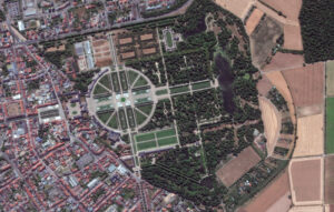 The origins of Schwetzingen Palace (Schloss Schwetzingen) date back to 1350 when a small, moated castle occupied the site. For several centuries, the baroque Schwetzingen Palace served the Wittelsbach dynasty as a summer residence and hunting palace. The Schwetzingen mosque is Germany’s last representative of the paradigmatic “garden mosques” that were popular in late 18th Century Europe and emblazoned the palace gardens of absolutist rulers. By erecting a mosque, along with other “exotic” buildings, kings and dukes aimed to show their enlightenment, tolerance, and cosmopolitanism. After an eventful history, Schwetzingen flourished under the Palatine Prince Elector Carl Theodor (1724 – 1799). The palace owes its current form to the Prince Elector Johann Wilhelm, who commissioned alterations in 1697. The addition of two wings significantly increased its size. Schwetzingen Palace reached the height of splendor under the Prince Elector Carl Theodor. He instructed the leading landscape architects of the age to design the gardens. In the late 18th Century, an English-style landscape park was added to the Baroque garden – the Arborium Theodoricum, as it is called, is one of the earliest of its kind in Germany. More than 100 sculptures are scattered throughout the gardens and an assortment of buildings add to the ambience, including the Apollotempel (temple of Apollo), a small, round building that houses a statue of the ancient Greek god of light and the arts, playing the lyre. The Badehaus (bath house) is a summerhouse with its own garden, modelled on an Italian villa. The Türkischer Garten (Turkish gardens) is where you’ll find the mosque, the largest structure of its kind in a German garden. The palace’s rooms contain furniture from the 18th and early 19th Century. The palace theater in the north wing is a particular highlight. It was the first theatre in Europe with galleries – and it is still used as a venue for performances today. During the last 220 years, the site has served different purposes. It was an open-air opera stage where Mozart’s, “The Abduction from the Seraglio,” was performed; a military hospital during Germany’s war with France in 1870; a meeting room for the founders of Germany’s first Islamic Academy (a project that was never realized); and as a nightclub for American soldiers after World War II. Today, Schwetzingen Palace is a state-owned heritage monument, cared for by the institution of the State Palaces and Gardens of Baden-Württemberg. The garden is publicly accessible, while tours are led through the Palace and Theatre. In the image featured, we can see the palace with its dark colored roof and numerous wings branching off from the central part of the structure. Behind can be found a circular garden and beyond, several buildings, more gardens, and woods with maze-like paths meandering through. This 30-cm WorldView Legion image was collected on July 1, 2025, and has custom processing and color balance applied by Apollo Mapping. (Satellite Imagery © 2026 Maxar Technologies)
In this monthly article, we travel the world to check out unique, fun and sometimes a bit weird 30-centimeter (cm) color imagery samples from the WorldView constellation. In December, we looked at Gibbs Farm in Makarau, New Zealand. For this edition of the 30-cm Color WorldView Image of the Month, we feature an image of Schwetzingen Palace in Germany.
30-cm WorldView-3 (WV3) launched in late 2014, WorldView-4 (WV4) launched in late 2016 and then the first WorldView Legion satellites launched in 2024. Taken together, this is the most advanced satellite constellation the commercial marketplace has ever had access to. Here are a few of the features that really set these satellites apart from the competition:
- Improved Resolution
- Higher resolution means you can see more detail in WorldView imagery.
- Data collected at nadir will have 31-centimeter (cm) panchromatic, 1.24-meter (m) visible and near infrared, 3.7-m SWIR (WV3 only) and 30-m CAVIS (WV3 only) bands.
- Additional Spectral Bands
- If spectral analysis is part of your project, then no other satellite can match WorldView-3 and WorldView Legion with their 8 bands of visible and near-infrared data; and then 8 shortwave infrared bands (WV3 only) which are crucial for geological studies.
- Better Positional Accuracy
- With accuracies of 3.5-m CE90% or better (without ground control even!), the 30-cm WorldView constellation has no rivals for its enhanced positional accuracy.
- Daily Revisits
- With multiple WorldView-3 and WorldView Legion satellites orbiting our planet, daily revisits are available for most locations.
- WV4 is no longer collecting new imagery.
- Increased Collection Capacity
- WV3/4 feature 13.1-km swath widths (at nadir) with the ability to collect up to 680,000 square kilometers (sq km) of high-resolution data per day per satellite (though WV4 is dead now).
- When fully launched, WorldView Legion will feature six 30-cm satellites, significantly boosting the collection capacity of this leading high-resolution constellation.
If you are interested in WorldView-3, WorldView-4 and/or WorldView Legion imagery for your next project, please let us know by phone, 303-993-3863, or by email, sales@apollomapping.com.
You can also find more WV3 samples and technical information on our website here; WV4 samples and information can be found here; and then finally here is more information about WorldView Legion.
Before you come for me and say I haven’t done my research, I’m well aware that the 2026 official Pantone Color of the Year is Cloud Dancer; however, if you ask researchers in Germany, it is azurite blue, a stunning, naturally occurring, bright blue. They have found evidence that Paleolithic civilization might have been using this particular blue. A recent Science Daily article says, “For many years, experts assumed that Ice Age artists relied almost entirely on red and black pigments, since nearly all surviving artwork from this time uses those colors. The limited palette was often attributed to a scarcity of blue minerals or to the belief that blue held little appeal.” It has the scientists rethinking color and ice age people’s perspective on the importance of color. “The presence of azurite shows that Paleolithic people had a deep knowledge of mineral pigments and could access a much broader color palette than we previously thought – and they may have been selective in the way they used certain colors,” Dr. Izzy Wisher, lead authority in the study, says. This makes me wonder…What importance does color have on our world?
As map makers, we know that color is vital. Professionals know to question “default” and consider what message we want to convey with the map. The Color Brewer by Cynthia Brewer and Mark Harrower at Penn State has long been a go-to. If you haven’t checked it out, you should. John Nelson regularly shares considerations and how-to’s on color and maps on his blog, Adventures in Mapping. Some of my favorite maps that feel more like professional graphics do a great job of sending the message without a traditional legend. In particular, I admire his map of happiness that uses color, shape and size to quickly convey happiness in countries on the map. Amidst the dark background, it is easy to understand the data factors contributing to happiness, like a complex multimedia piece of art that causes us to react.
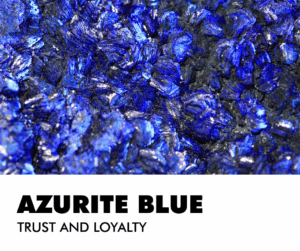 Image created in Canva by BD.
Humans respond to color. According to the Interaction Design Foundation, they respond in three ways: “biologically (e.g., red = fear), culturally (e.g., red = wellbeing in many Eastern societies) and personally from experience. Designers use color symbolism in (e.g.) logos to gain users’ trust and attention.” Many careers involve applying color theory across many fields, including Graphic Design, Interior Design, Fashion Design, and Branding, with roles like Color Consultant, Color Specialist, and roles in Packaging, UX/UI, and Web Design where you guide choices for mood, function, and appeal, often using digital tools and focusing on trends, psychology, and client needs. Think about it…Why do so many logos in the geospatial community have blue and green in them? If you’re working in the geospatial industry, we most often see earth colors and subconsciously trust those colors
Most people have a favorite color. Do you trust that color more? The folks at Verywell Mind speak about the effect of color psychology on mood feelings and behaviors. Have you been house hunting and find yourself jarred by the owner’s color choices? As you tour the house, you think, “That red kitchen has got to go!” or “What were they thinking by painting a whole room chartreuse?” For that reason, many real estate professionals will tell you to neutralize your home’s color palette before listing it. Do we trust beige? Not necessarily, but it does provide room for imagination. Interestingly, blue is considered the color of trust and loyalty. No surprise that it would become a popular choice for businesses. If there’s a color design dilemma at my house, blue generally wins. Everyone in the house likes blue.
If you like blue, then you might wear more blue. Are you wearing the right blue? Is blue in your wardrobe color collection? Some colors do make you look your best. These color collections are grouped by season and then light and dark various of those home seasons. You can hire an expert or find an app and let AI tell you. You probably already know. You feel best in some colors over others. Your hair color, eyes, and skin tone all play a role in looking your best…in color.
Color has been part of human life for ages. Early cave paintings featured red due to abundant clay pigments. Nature continually reveals new color combinations that influence our homes, fashion, and creativity. Which color inspires you most this year?
If you need me, I’m on a mission to find the perfect shade to repaint my bedroom. I’ve been living with samples for months, but it’s time to decide.
Barbaree Duke
Geospatial Crusader
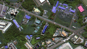 A 50-cm color DS-EO image collected on June 13, 2025 over Muara, Brunei.
Are you seeking high-resolution images tailored for precision-focused applications within the equatorial region? Launched from India in 2022 by Geo-Insights, the 50-cm DS-EO satellite system can collect the imagery you need, and collect often. DS-EO carries an electro-optic, multi-spectral payload that provides 4-band 2-meter (m) multispectral and 50-centimeter (cm) panchromatic images for advanced spectral analysis. It can produce accurate 4-band imagery and boasts a panchromatic band wavelength range of 450–800 nanometers to capture broad-spectrum black and white imagery with high resolution at 50-cm.
Because of the twice daily visits, you can utilize reliable, timely DS-EO data with exceptional detail in the equatorial zone. With 16-bit depth, 50-cm panchromatic resolution, and four 2-m multispectral bands, it is possible to conduct analyses that include object identification, as well as assessments of vegetation health and water quality.
Learn more about how DS-EO offers sharp details for insightful analytics, identifying multi-faceted objects in environmental or maritime circumstances!
You can query 50-cm DS-EO data anytime on Image Hunter. And if you have any additional questions about tasking DS-EO or archive data from this satellite system, you can email us now at sales@apollomapping.com.
Every Friday evening, I gather with a group of girlfriends for dinner and games, a tradition that grew out of the pandemic that has become a cherished mainstay in all our lives. We range in age from our 50s to 80s with a myriad of careers, backgrounds, and hometowns. While there is never a shortage of discussion, we were introduced to a product called “Table Topics.” It’s a box of discussion questions and topics to encourage conversation. A fun discovery for me has been the number of questions that are tied to geography or lend a geographic answer. Let’s pursue a few together. I’ll start, then you can contribute to the comments.
What’s the most beautiful place you have ever seen?
I find beauty in nature and landscapes. It’s hard to pick a favorite; however, there is a place that took my breath away unlike any other place…The Grand Canyon. If you have been there, you know. If you have not had the pleasure, start planning an adventure. There is nothing like walking onto that patio of the lodge and taking in that south rim vista for the first time. The time of day or weather does not dull the sheer grandeur and colorful expanse. As I gazed out and watched the birds surfing the wind currents, I couldn’t help thinking of pioneers headed west in a wagon across all that flat land only to find the canyon. Now that is a conundrum! Whether you download some great imagery or take a 3D video tour, it doesn’t replace the being there. Where have you been?
 Image created in Canva by BD.
Where do you want to visit?
How long do we have to answer this one?! While I’m luckier than most, I still have so many places in the world that I would love to see in person. What’s on your list?
Some things on my to do list:
- Gaze at the northern lights (We were lucky enough to see some pinks and purples last year as they dipped WAY south, but I still want to see them dance!)
- Attend a play at THE Globe Theatre (My inner literature nerd wants to be there IN PERSON on a bench to see a Shakespearean play.)
- Go on an African safari (I’d love to see the landscape and animals in their habitats.)
- See Istanbul (This ancient city has seen many empires and travelers. In writing curriculum, this city has appeared in so many eras as a pivotal place and important discussion point for the Roman Empire, the Black Plague, and trade routes.)
- Retrace around the world in 80 days (I’ve taught this novel and enjoyed opening students’ minds to mapping and adventure.)
What place holds the most memories for you?
The simple answer is home, but more specifically a seat at my dining table. There’s something special about a family table regardless of what “the table” looks like or the type of food. Oldways describes it as “the heartbeat of a family.” It’s easy to find solid research on the importance of gathering and talking together. This research certainly rings true from my experience. The family walnut-stained table is currently mine to curate, but it’s been with my family for as long as I can remember. I remember having a snack after school or doing my homework at my grandmother’s house at that table. It was “the adult table” for every Thanksgiving, Christmas, and family gathering from my childhood. When my mother inherited the table, it became the place where we welcomed many guests to offer some southern hospitality and feed them well. Can you smell the warm macaroni and cheese? Now, that table sees my friends and family as well as craft projects and stray items with cherished memories looming and new ones a spontaneous invite away. What’s your memorable place?
This article is the 14th in the Remotely Spatial series. As we close out 2025, perhaps remember to find things that make you happy, use your spatial skills for good, and be creative. Whether you’re celebrating, enjoying a cocktail, dining with friends, or on a safari, life has a point. Find your adventure. Keep it simple and encouraging!
If you need me, I’ll be enjoying the lights and sounds of the holiday season. It’s my favorite!
Barbaree Duke
Geospatial Crusader
 Imagine working with this colorful 50-cm WorldView-2 image with 8 bands? That is twice the spectral information for the same low cost. This 50-cm Maxar WorldView-2 image was collected over Central City, Pennsylvania on October 1, 2012.
Did you know that given recent pricing changes for high-resolution 8-band WorldView-2, WorldView-3 and WorldView Legion satellite imagery, you can order this additional spectral information for the same price as 4-band data?! Yep, you heard that right, so why wouldn’t you uplevel your spectral analysis for no additional cost?!
And additionally, you might not know that most 3-meter PlanetScope images can be delivered with either 4-bands or 8-bands for the same cost as well!
So, when it comes time to get started on a project that includes change detection, land use-land cover classification, vegetation analysis, and/or any other spectral analysis, why not use 8-band WorldView or PlanetScope data for the same cost?!
Send us an email at any time to uplevel your spectral analysis for no additional cost by using 8-band satellite imagery for your geospatial next project.

Cricket’s Chirp is created for Apollo Mapping by Ron Ruelle, a Wilmington, NC (formerly Boulder, CO) based cartoonist, lllustrator and teacher. No animals are harmed in the creation of these comics, but Ron sometimes breaks a pencil in frustration. You can see more of his work at www.ronruelle.com
In November, we looked at Flamenco Beach on the island of Culebra Island, Puerto Rico, which features rusting, graffiti-covered tanks. This month for the Pléiades 1–Pléiades Neo Point of Interest, we check out Serra de Leba Pass in Angola.
About the Point of Interest: Serra de Leba Pass in Angola is famous for its altitude (Mount Moco at 2,620 meters/8,600 feet is the highest mountain in Angola), for its beauty, and also for the Serra da Leba pass which climbs to 1,845 meters/6,050 feet in altitude.
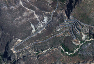
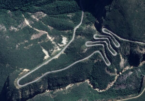 These two satellite images show the impressive mountain range known as Serra de Leba in Angola. In the first image, the windy pass road forms a serpentine shape clearly seen in the Pléiades Neo 3 30-cm color image from October 6, 2023. In the Pléiades 1A 50-cm color image taken April 29, 2023, you can see the depth and height of the mountain range as the pass road winds through it. These images have custom processing and color balancing applied by Apollo Mapping. PLEIADES © CNES 2025, Distribution Airbus DS.
Fun Factoids: (1) The mountain range, Serra de Leba, happens to be home to one of the famous hairpinned roads in the world. (2) Legend has it that the Serra da Leba Pass is named after a Portuguese woman who designed and built the road, but died after she viewed it on the very day the project was finished. (3) Situated some 20 miles west of the city of Lubango, on the southwestern part of the country, the road is totally paved. It’s called Estrada Nacional 280. (4) Construction on this breathtaking mountain road began in the colonial era in the late 1960s and was opened in the 1970s. (5) The most challenging part of the drive is 29.7-km (18.45-mile) long, running from Renato Grade to Leba. It spirals down from the ‘plano alto’ (high plateau) elevation of 1,845 meters/6,050 feet to almost sea level in just over 10 kilometers, literally traversing 3 or 4 different climate zones during any ascent or descent. The drive is very steep, reaching a maximum gradient of 34% through some of the ramps.
The 50-cm Pléiades 1 High-Resolution Satellite Constellation
The Pléiades 1 constellation (or at least part of it!) has been in orbit since December 2011 and if you have not had a chance to check out any sample imagery, take a few moments and have a look at the gallery on our website. If you work with high-resolution imagery, you should consider Pléiades 1 and Pléiades Neo for your next geospatial projects.
A variety of Pléiades 1 products are available from both a well-established archive and as a new collection, including 50-centimeter (cm) pansharpened imagery and 50-cm panchromatic–2-meter (m) 4-band multispectral bundles. We are happy to discuss the technical specifications, pricing and tasking options available with both of these satellite constellations.
The 30-cm Pléiades Neo High-Resolution Satellite Constellation
Pléiades Neo is our newest high-resolution satellite constellation. The first Neo satellite went up in April 2021 and the second in August of the same year. This 30-centimeter resolution constellation will add two more satellites in the next few months and upgrade from daily to intraday revisits. Pléiades Neo has six multispectral bands with 1.2-meter resolution, including a deep blue and two infrared bands, along with a 30-centimeter resolution panchromatic band.
The archive is growing every day, and the satellites are available for new collections, making Pléiades Neo the perfect solution for site monitoring. Check out our beautiful sample images in the Pléiades Neo gallery.
More sample images and technical information about Pléiades 1 can be found on our website here; while the same can be found here for the Pléiades Neo constellation.
The Apollo Mapping sales team can answer any questions you might have about Pléiades 1 and/or Pléiades Neo. We can be reached at (303) 993-3863 or sales@apollomapping.com.