
If your next mapping project requires large-area coverage of a seamless digital elevation model (DEM), then it is time to check out Airbus’ updated WorldDEM product, boasting new pricing and improved accuracy! WorldDEM Neo has improved 5-m resolution and is derived from TerraSAR-X and TanDEM-X radar stereo pairs. However, the radar pairs used to create this 5-m elevation dataset are more recent than its predecessor as they were collected from 2017 to 2021. WorldDEM Neo is available as both a digital surface model (DSM) and a digital terrain model (DTM) with an impressive absolute vertical accuracy of < 1.4 m Linear Error 90% (LE90)!
 Check out a sample of WorldDEM Neo 5-meter DSM data from Phu Hoi, Vietnam.
The 5-meter WorldDEM Neo DTM is available as a Level 1 or Level 2 product. The Level 1 product is an automated DTM and removes surface structures from the WorldDEM Neo DSM. The Level 2 product features manual processing resulting in a higher-quality DTM. This includes the removal of surface structures from the WorldDEM Neo DSM such as built-up areas and tall vegetation. It also incorporates the refinement of land cover borders before reducing the elevation to the terrain level and extending the preservation of ridge lines and canyons with the precise modelling of transport structure like bridges, motorways, embankments; and then detailing the extents of hydrographic features like water bodies, reservoirs, rivers, and respective alignment of water surface heights.
You can search for WorldDEM Neo now on Image Hunter; and then download a sample of DSM, Level 1 and Level 2 DTM data from the same location here.
To get updated DEM price list which includes 5-m WorldDEM Neo DSM and DTM data, send an email to sales@apollomapping.com.
In the meantime, check out these key specifications for 5-m WorldDEM Neo:
- Resolution: 5-meter pixel spacing
- Absolute Vertical Accuracy: < 1.4 m Linear Error 90% (LE90)
- Absolute Horizontal Accuracy: < 6-meter (90% circular error)
- Geographic Coverage: nearly pole to pole, same as 12-m WorldDEM
If you are searching for medium and high-resolution satellite imagery, the search is over as Image Hunter is the solution you’ve been looking for! Featuring satellite and aerial imagery as well as digital elevation models (DEMs) from a constantly expanding list of 60+ constellations/datasets and 19 vendors, our database contains more than 500-million images/records meaning there is just no other website out there with this breadth of commercial data products. Our interface is slim-lined and modern, loading quickly on all platforms, browsers and operating systems. Further, our database is updated multiple times an hour with the most recent images collected by WorldView-3, Pléiades 1, PlanetScope, SuperView-1 and many more so you are sure to get the most current view of all the imagery and DEM databases we work with. Once you submit your request, an Apollo Mapping representative will be in touch within 4 Illinois business hours to get you the pricing information you need for your project.

So why wait? Give Image Hunter a try now to find the imagery and/or DEM data you need for your next mapping project!
Key Improvement(s) From The Past Month
Sometimes fixes take longer than you hope but good news, this month we made major head way and brought back both KOMPSAT 2/3/3A and GeoSat-2 previews, woot woot! This heavy code lift did take time away from other priorities we had, but fear not, we have already pivoted back to the new clip tool and hope to have version 2 in place soon.
Here is a summary of the changes/improvements we made to Image Hunter during the past month:
- Restored 75-cm GeoSat-2, 40-cm KOMPSAT 3A, 70-cm KOMPSAT 3 and 1-m KOMPSAT-2 previews!
- Improved metadata handling for 30-cm WorldView Legion.
- Changed the name of our new clipping tool to: Clip Polygon To Image.
Data Alert – An Automated Daily Imagery Search
Have you checked out Data Alert which lets you define an area of interest anywhere around the globe, the resolution your project requires and the number of months we should keep the alert active? Once an alert is set up, we check for new data over your area of interest every single day, and send you an email when we find coverage that meets your specifications. We have a short YouTube video with directions to set up a Data Alert, check out the last video; and we have written directions for Data Alert here.
The Sensors Available in Image Hunter
As you might have seen in past articles, we now feature hourly updates (seriously!) of GeoEye-1, KOMPSAT 3/3A, Pléiades 1 and Neo, SPOT 6/7, SuperView-1/2/Neo, WorldView-1/2/3/Legion!
Image Hunter can be accessed 24 hours a day, 7 days a week and is a one-stop shop for every major source of medium and high-resolution satellite (and aerial!) imagery on the market today, including:
- WorldView Legion
- WorldView-4
- WorldView-3
- WorldView-2
- WorldView-1
- QuickBird
- GeoEye-1
- IKONOS
- EROS B
- KOMPSAT-3A
- KOMPSAT-3
- KOMPSAT-2
- Pléiades 1 constellation
- Pléiades Neo constellation
- TerraSAR-X (TerraSAR-X, TanDEM-X and PAZ)
- GEOSAT-1
- GEOSAT-2
- TripleSat
- BJ3A
- BJ3N
- SPOT 1 to 7 constellation
- RapidEye
- GaoFen-2
- GaoFen-1
- ZiYuan-3 01/02 (mono and stereo!)
- FORMOSAT-5
- FORMOSAT-2
- ALOS PRISM (stereo)
- AW3D Standard (DEM)
- SkySat constellation
- PlanetScope constellation (including 5-band SuperDove data)
- SuperView-1 constellation
- SuperView-2
- SuperView Neo-1 01/02
- SuperView Neo-3
- Landsat 1-8
- TeLEOS-1
- DS-EO
- Hexagon (HxGN Content Program aerial imagery) imagery + DEM
- WorldDEM
- WorldDEM Neo
- Vricon DEMs
- Orbita Hyperspectral Satellite (OHS)
- KazEOSat-1
- KazEOSat-2
- Jilin-1 Optical
- Jilin-1 Video (including nighttime imagery)
- Jilin-1 GF/DP
- Jillin-1 KF
- Orbita Video Satellites-1/2/3 (OVS-1/2/3)
- BlackSky Global series
Key Features of Image Hunter
If any of our readers have struggled with other geospatial search engines that are clunky, only query one data source and/or do not provide image previews, then Image Hunter is the solution to your woes as it features:
- Online browsing of satellite and aerial imagery from 19 data providers and 56 satellite and aerial imagery derived datasets.
- Near-instantaneous loading of low-resolution preview imagery with collection date, cloud cover and other key metadata.
- The ability to define your area of interest by address, coordinates, geometric shape or shapefile/KMZ.
- A responsive basemap with street names to provide spatial context when discovering data as well as crowd-sourced updates for the most accurate map possible.
- Exports of the area of interest you create as well as the scenes you select in shapefile or KMZ format.
- Support for all operating systems, and not just our friends with Windows machines!
Image Hunter can be accessed here all day and night, we are excited to find out what you think about our imagery search engine! So if you have any ideas and/or feedback to improve Image Hunter, please let us know at sales@apollomapping.com or (303) 993-3863.
Do you work in urban planning, environmental monitoring, or resource management and are tasked with identifying land use, tracking changes in urban areas, assessing forest health, and planning development projects? If so, high-resolution imagery with its large concentration of pixels for greater detail enables precise analysis and measurement of features not visible in lower-resolution images, allowing for accurate mapping, less need for site visits, and detailed documentation of our real world.
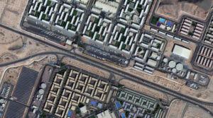 A 30-cm WorldView Legion image courtesy of Maxar collected over the NEOM Campus in Saudia Arabia on December 2, 2024. Apollo Mapping has applied custom color balance and image enhancements.
Since its launch in 2024, 30-centimeter (cm), 8-band WorldView Legion is one of the most prolific 30-cm satellite constellations available in the high-resolution satellite imagery sector. With six satellites currently in orbit, the WorldView Legion constellation captures approximately 3.2 million square kilometers (sq km) of high-resolution 30-cm imagery daily which is added to Image Hunter (nearly) instantly. Additionally, its advanced multispectral sensor captures data across eight different wavelengths, offering exceptionally detailed perspectives of Earth’s surface; and facilitating the identification of small objects and the detection of subtle environmental changes in both urban and natural settings. Advanced applications such as bathymetry, vegetation assessment, mineral exploration, and wildfire monitoring are common use cases for 30-cm WorldView Legion satellite imagery.
With 90% of the world’s population residing between 45° North and 45° South latitudes, the constellation is optimized for quicker revisit intervals in these regions, while maintaining coverage of higher latitudes with two sun-synchronous satellites. Four WorldView Legion satellites circle the planet in persistent mid-latitude orbits. The WorldView Legion constellation operates across multiple orbital paths with a 10-km footprint at nadir, enabling frequent revisits – in fact, up to 15 times daily in select regions. This increased capacity and revisit rate for the most populated areas of the world creates a robust archive and advanced monitoring capabilities in these crucial regions. The revisit frequency supports comprehensive mapping, robust change detection, and in-depth analysis over extensive geographic areas. These capabilities allow the 30-cm WorldView Legion to support a wide range of geospatial applications, including projects requiring spectral analysis and intense detail.
With six active satellites in orbit, the WorldView Legion constellation stands out for:
- 30-cm panchromatic and 1.2-m 8-band multispectral imaging (coastal, blue, green, yellow, red, red edge 1, red edge 2, NIR).
- Offering four middle-orbit (MIO) satellites concentrated on the most populous areas of the planet.
- Imaging 500,000+ sq km daily from each satellite.
- Delivering an average of three daily accesses to locations between 40° North and South.
- Capturing images throughout the day, not just mornings, thanks to its MIO satellites.
The 30-cm WorldView Legion constellation allows Apollo Mapping to offer increased high-resolution imaging capacity and faster delivery times to customers across various sectors, including defense, mining, oil and gas, engineering, education and research, and humanitarian relief.
You can explore our entire satellite imagery archive today on Image Hunter!
To see how 30-cm, 8-band WorldView Legion imagery can support your next project, or get personalized recommendations, contact our sales team at sales@apollomapping.com now.

Cricket’s Chirp is created for Apollo Mapping by Ron Ruelle, a Northwest Ohio (formerly Boulder, CO) based cartoonist, lllustrator and teacher. No animals are harmed in the creation of these comics, but Ron sometimes breaks a pencil in frustration. He has a new collection of his weekly Skelton Comics available at www.ronruelle.com
- Hello to all my fellow technology nerds out there, this month we feature a big list covering a wide range of advancements, enjoy!
Microbes can produce clean hydrogen gas from abandoned oil wells.
Another reason to avoid ultra-processed foods.
There is a new state of matter in our earth’s inner core.
Sunlight converts methane into useable by products.
Could the geometry (and its evolution over time) of multidimensional spacetime explain the creation of mass?
X-rays image metal crystals growing in liquid metal.
Math existed even before we had numbers.
A new way to possibly live longer.
Black holes can literally twist space-time itself.
These viruses can eat antibiotic-resistant bacteria.
Effective, non-clogging filter for microplastics.
New method to destroy forever chemicals.
Humans also lived alongside wolves.
Breakthrough in next-generation computer chips.
This new material can change its color and texture.
 Stormy weather blanketed several areas, including Tropical Storm Barry, which dropped heavy rainfall with strong winds in parts of eastern Mexico and catastrophic flash flooding in central Texas. Hurricane Melissa tied with the 1935 Labor Day Hurricane as the strongest landfalling Atlantic hurricane on record. Cyclone Senyar was an extremely rare tropical storm in November and Typhoon Danas was the first typhoon to make landfall in Chiayi County, Taiwan, in nearly 120 years. Global tropical cyclone activity was above average with 101 named storms in 2025. (Image Credit: NOAA Global Climate Report)
- The annual Global Climate Change Report for 2025 has been released by NOAA’s National Centers for Environmental Information and reveals further proof that global climate change remains a concern. The year 2025 ranked as the third warmest year since global records began in 1850, finishing 1.17°C (2.11°F) above the 20th Century average of 13.9°C (57.0°F) with much warmer than average temperatures across the majority of the globe. Record high annual temperatures blanketed parts of the Arctic, Europe, Asia, Antarctica, the Southern Ocean and the western and central Pacific Ocean, while some areas experienced near to cooler-than-average conditions and no land or ocean areas experienced record-cold annual temperatures. North America experienced its fourth warmest year on record (+1.99°C / +3.58°F) with every month experiencing an above-average monthly temperature and nine of the 12 months ranked within the top 10 for their respective months. South America recorded its sixth warmest year on record with an annual temperature 1.27°C (2.29°F) above average and all 12 months warmer than average. Europe experienced its second warmest year on record at 2.15°C (3.87°F) above average, falling short of tying the record year of 2024 by 0.34°C (0.61°F). During the year, nine months ranked in the top 10 for their respective months and March set a new record as the warmest March on record. Africa recorded its seventh warmest year on record, finishing at 1.30°C (2.34°F) above average, and Asia’s surface temperature was 2.18°C (3.92°F) above average, the third warmest year on record. The Arctic region recorded its second warmest year on record, at 2.79°C (5.02°F) above average and falling just 0.15°C (0.27°F) short of tying the 2016 record; while its polar opposite, the Antarctic region, experienced its fourth warmest year on record (+0.53°C / +0.95°F).
- February happens to be the month of love and romance, and many people enjoy popping open a bottle of wine paired with their favorite dish to celebrate Valentine’s Day. GIS plays a role in wine production, but also in finding wineries to visit any time of the year, not just in February. The Napa County GIS/ArcGIS Online for wineries in Napa not only pins the locations of wineries to visit, but also the number of gallons produced per year and other details. The Three Rivers Wine Trail offers eight distinctive attractions all within a scenic drive of each other that are mapped out via GIS. Another publicly available GIS identifies the locations of wineries in Los Angeles County, while the state of Maryland maintains a GIS of local wineries for tourists and residents to visit. A more in-depth look at wineries’ use of GIS can be seen at Scheid Vineyards, where the vineyard is constantly monitoring their vines for the presence of harmful insects, diseases, and mildew. Recording pest sightings and their locations in the field and then directly transmitting that information to the GIS team for analysis allows ranch managers to take immediate action to combat a disease or insect invasion and to minimize possible damage to the vines.
Brock Adam McCarty
Map Wizard
(720) 470-7988
brock@apollomapping.com
 This map shows the areas imaged by the WorldView-2/3 constellation from June 1 to August 31, 2025 over Australia and its islands. Please note that in many instances, multiple images were collected over the same area which is difficult to portray on this static map.
In this monthly piece, we give our readers a sense of the high-resolution imagery coverage collected over a geography during a specified window. To do this, we pick a high-resolution satellite constellation, a defined time period and area of interest, then report key statistics on the total amount of imagery collected in square kilometers (sq km). Without further delay, let’s jump into our analysis.
Graphic Region of Interest: Australia plus islands
Land Mass Covered: 7,683,406.3 sq km
Time Period: June 1 to August 31, 2025
High-Resolution Satellite Constellation: WorldView-2/3
WorldView-2/3 Constellation Imaging Statistics – Australia
Total Area Collected: 4,288,270.8 sq km; 23,305.8 sq km per satellite/per day
Area Collected @ 20% or Less Clouds & 30 Degrees or Less Off-Nadir: 2,631,610.7 sq km; 14,302.2 sq km per satellite/per day; 61.37% of total

We love maps.
We love imagery.
We love work breaks.
We hope you like them as well!
The Maha Kumbh Mela is a massive Hindu pilgrimage, held every 144 years in Prayagraj, that draws millions of devotees to bathe in the holy confluence of the Ganges, Yamuna, and Saraswati rivers. It is the largest of the Kumbh Melas, which are rotating religious festivals held at four sacred locations in India: Prayagraj, Haridwar, Nashik, and Ujjain.
The Maha Kumbh Mela translates to “Festival of the Pitcher,” referring to a mythological pot of immortality from which drops fell at these four locations, making the rivers’ waters spiritually purifying. It is considered the largest peaceful gathering of people in the world, drawing millions of pilgrims, which we’ve written about before.
The Second Shahi Snan is considered the most significant for spiritual bathing because of the “Maun” or silence observance, and it attracts the largest crowds. It is believed that bathing on this day, especially while in silence, not only purifies the soul but also improves one’s speech and sweetness. It also is a day to honor ancestors through rituals like Pitru Puja and tarpan. Many devotees observe Maun Vrat (a vow of silence) for spiritual reflection.
For this month’s Imagery Work Break, we feature a Pléiades Neo 3 30-cm color enhanced photo from January 29, 2025. It was taken over Prayagraj, Uttar, during the morning of the Second Shahi Snan. Donating grains, sesame seeds, or other items is a common practice to attract positivity and peace on this day.
Have a great rest of your workday! 😊
(Image Courtesy: Airbus. Processed by Apollo Mapping for improved color accuracy and clarity.)
In this monthly feature, we span the globe to examine Our Changing Landscape with a time series of medium-resolution PlanetScope satellite imagery. The PlanetScope constellation dates back to 2016 and collects hundreds of millions of square kilometers of four and eight-band 3-meter imagery daily! In January, we visited Ayod, Sudan, to check out the devastating September 2025 floods. For the February edition of this series, we head down-under to watch the resurgence of Kalamurina Wildlife Sanctuary in the Outback of Australia.
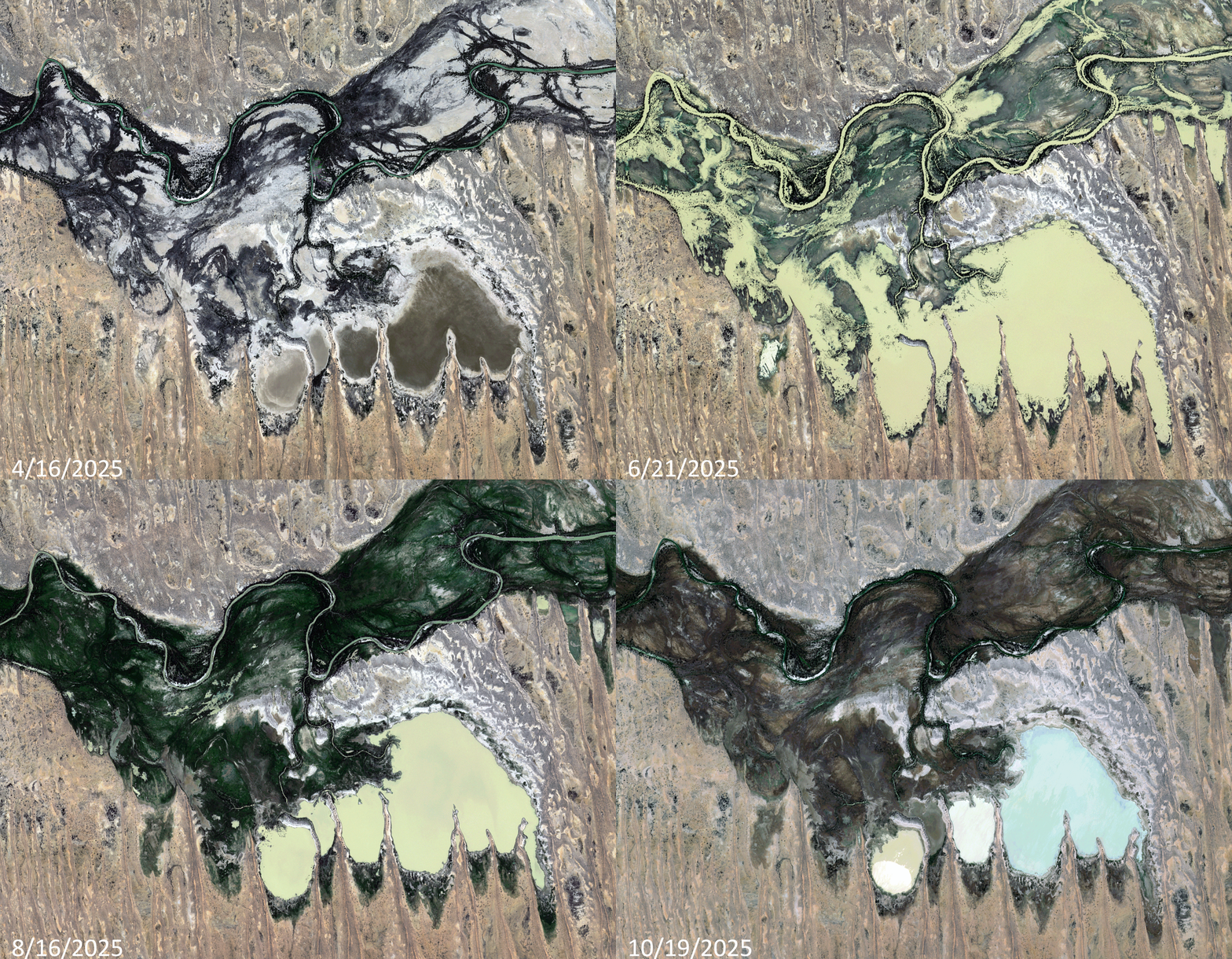 Click on the image above to see an animation of 3-meter natural color PlanetScope image collected over Kalamurina Wildlife Sanctuary on April 16, June 21, August 16, and October 19, 2025. First off, apologies for the shifted position of the June and August images – this can happen in rare cases with remote PlanetScope data. In this animation, you can see how dry and barren the landscape is in the April 16th image. By the June 21st image, the rains have started in this region and have started to fill the ephemeral ponds and rivers that flow through the sanctuary; and then in August 16th image, you can see that the ponds and rivers have already started dry up but the life-giving water they brought to this landscape have caused a huge re-birth of the vegetation here. And then finally, by the October 19th image, you can see more of the water has evaporated and the green landscape has started to dry out and thus the vegetation is drying out and desiccating. (Images Courtesy: © Planet 2026)
The PlanetScope Microsat Constellation
PlanetScope is a constellation of more than 240 microsats referred to individually as Doves. Each Dove is able to collect up to 20,000 square kilometers (sq km) per day of 3-meter (m) 4-band multispectral (i.e. blue, green, red and near-infrared [NIR]) imagery; and newly launched SuperDoves collect 8-band multispectral adding in valuable red-edge spectral data. Across the constellation, PlanetScope is archiving more than 200 million sq km of medium-resolution imagery a day, making it the go to source for daily imagery over most locations. This massive archive dates back to 2016, offering the most complete and continuous record of spatial data on the planet since the start of the constellation’s ongoing launch schedule. Collecting 3-meter multispectral imagery is the equivalent of ‘high-resolution’ multispectral data imaged by a 75-centimer (cm) satellite (as this satellite would feature 75-cm panchromatic and 3-m multispectral), making PlanetScope an extremely competitively priced option at just $2.25 per sq km. With well registered images and nearly daily collections of most locations, PlanetScope is the ideal imagery source for this current-events focused series, Our Changing Landscape.
Rebirth of Kalamurina Wildlife Sanctuary in the Outback of Australia
In June, a rare inland sea formed in Australia’s arid center, reviving the baren desert and drawing wildlife and visitors to the Outback to check out the phenomenon. Kati Thanda-Lake Eyre is a 3,668-square-mile ephemeral lake that actually only receives just 5.5 inches of rain on average per year. It could be more readily thought of as a giant salt pan in the south Australian desert due to its lack of water.
There are two main arteries feeding Lake Eyre — the Georgina-Diamantina River, which began filling Kati Thanda-Lake Eyre’s north in early May 2025, and the Cooper Creek system. Cooper Creek, named by early British explorer Charles Sturt, isn’t much of a creek despite its name, according to Accuweather.
This year, after Tropical Cyclone Alfred dumped on inland Queensland in March, the water flowing down to Kati Thanda-Lake Eyre appeared to be filling it for just the fourth time in 160 years. The lake, when filled with refreshing water, sees the desert ecosystem convert into something fully different with shrimp and crustaceans, fish, endangered animals, waterbirds and more. Even native shrubs will crop up. However, with this rebirth of the area, tourists flock to see the sharp changes. That’s had its ups and downs, though, with the South Australian government enforcing a ban on people walking on the lake bed to help protect the salt crust and surface.
Conservationists Annemarie van Doorn and Luke Playford manage the Kalamurina Wildlife Sanctuary, a 679,667-hectare property owned by the Australian Wildlife Conservancy on the eastern shore of the lake. The vastness of their world can only truly be understood from the helicopter they use to do their conservation work. The property they alone are responsible for is the size of Delaware.
“This is special because it’s a natural event,” Playford told Accuweather. “It’s the largest flood in 50 years, and while that did a lot of damage in Queensland, this is an act that’s not induced by climate change. It’s a special occasion.”
If you would like to find out more about using 3-meter PlanetScope imagery for your academic studies, engineering projects or any landscape analysis, let us know at sales@apollomapping.com or (303) 993-3863.