
- As April rolls in, we roll out our latest (long) list of technology news!
Life teems even in the world’s driest locations.
Interesting research on tipping culture.
Life appears to have the ability to jump between planets.
This organic battery stores energy in its molecular structure.
SAR data can help detect bridge failures before they happen.
Ocean microbes can adapt to warmer oceans.
3D models of ants!
A new alloy developed for recycling waste vehicle scraps.
Cat genetics could help solve human cancer.
Ground-breaking catalyst to convert CO2 to methanol discovered.
Here is a list of the most likely planets with alien life.
Birds and bees drink alcohol as well!
These flies produce their own heat and antifreeze.
Super food for super-charged bees.
Are cows smarter than we think?
Biodegradable film outperforms plastic.
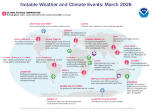 Sea ice extent in the Arctic was the second smallest on record for March while the Antarctic region saw a March temperature that tied as its fourth warmest March on record. Northwestern Argentina experienced significant flooding, with heavy rainfall causing rivers to overflow and causing widespread damage. The globe saw its sixth lowest March sea ice extent and Oceania experienced a warmer than average March. Tropical Cyclone Narabelle became the second storm since 1980 to make three severe intensity landfalls. Strong storms also swept across the Arabian Peninsula while Storm Therese dumped heavy rainfall on the Canary Islands, leading to flash flooding that damaged homes and roads. (Image Credit: NOAA Global Climate Report)
- The Global Climate Change Report for March 2026 has been released by NOAA’s National Centers for Environmental Information and it reveals further proof that global Climate Change remains a significant concern. March 2026 was the second warmest March in the 177-year global record, with a surface temperature 1.31°C (2.36°F) above the 20th Century average. Only March 2025 recorded a higher temperature. The global ocean recorded its second-warmest March at 0.91°C (1.64°F) above average, behind only 2024 (+0.97°C / +1.75°F). Meanwhile, the global land surfaces ranked third warmest at 2.19°C (3.94°F) above average.
- Even in 2026, there still are families who lovingly assembly small May Day baskets for neighbors, friends and relatives. As the tradition goes, May baskets used to be filled with flowers, candies, and treats, then left hanging on front doorknobs or sitting on a porch. The basket-giver would sneak onto the front stoop, situate the basket, ring the doorbell and scamper off. The May Day basket is supposed to be a surprise for the recipient. This act of affection dates back to the 1800s when a reporter for the Illinois-based Gazette described a May basket as being made of paper and can contain almost anything. In the olden days, boys would hang them on their sweetheart’s doorknob as a sign of affection or to secretly show interest, according to the St. Louis Republic. Two bold children hung May baskets on the White House front door on May Day 1925. The Indiana, Pennsylvania, Gazette reported that then First Lady Grace Coolidge found her admirers and gave them flowers she had picked. For some communities, May Day and the creation of baskets “became almost as exciting as Christmas.” A local Extension home economist reminisced in Humboldt, Iowa’s Independent in the late 1900s that her families used old milk cartons for containers, which they then filled with popcorn and Boston crème pies. One way some families have modernized May Day and the act of leaving baskets is by using ArcGIS to map out their delivery route for the fastest paths and the quickest getaway times. Once this routing and analysis is completed using ArcGIS Online, it then can be used in Navigator. Here’s a tutorial on how to make your own May Day basket delivery route using GIS technology.
Brock Adam McCarty
Map Wizard
(720) 470-7988
brock@apollomapping.com
If you are searching for medium and high-resolution satellite imagery, the search is over as Image Hunter is the solution you’ve been looking for! Featuring satellite and aerial imagery as well as digital elevation models (DEMs) from a constantly expanding list of 70+ constellations/datasets and 19 vendors, our database contains more than 500-million images/records meaning there is just no other website out there with this breadth of commercial data products. Our interface is slim-lined and modern, loading quickly on all platforms, browsers and operating systems. Further, our database is updated multiple times an hour with the most recent images collected by WorldView-3, Pléiades 1, PlanetScope, SuperView Neo and many more so you are sure to get the most current view of all the imagery and DEM databases we work with. Once you submit your request, an Apollo Mapping representative will be in touch within 4 Illinois business hours to get you the pricing information you need for your project.
So why wait? Give Image Hunter a try now to find the imagery and/or DEM data you need for your next mapping project!
Key Improvement(s) From The Past Month
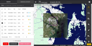
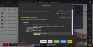 Our new Clip Polygon To Image tool is live! Give it a try to automatically calculate the coverage areas of a complex set of imagery from various data vendors and satellite constellations.
After a few hints at a new and improved Clip Polygon To Image tool, we dropped a huge new update to the clipping tool and it is pretty amazing if we do say so! We have added in two ways to reduce overlap between various vendor’s datasets which means we have added two ways to save you money when ordering overlapping satellite imagery from multiple vendors. For most folks, the automated overlap reduction tool will be there go-to as you can rank your selected images by importance whereby we maximize the coverage of the most important scenes to your project while minimizing the coverage (down to 500-meters for the overlap area) for the less important scenes. There is also a highly interactive mode where you can go scene by scene and adjust the overlap accordingly. We would be happy to hear any feedback our users might have about this exciting new update!
Here is a summary of the changes/improvements we made to Image Hunter during the past month:
- Sometimes an update is big enough that it takes up all of our time, and well that is what happened this month as our ‘only’ update this month was the overlap tool in our Clip Polygon to Image function – we hope you enjoy it!
Data Alert – An Automated Daily Imagery Search
Have you checked out Data Alert which lets you define an area of interest anywhere around the globe, the resolution your project requires and the number of months we should keep the alert active? Once an alert is set up, we check for new data over your area of interest every single day, and send you an email when we find coverage that meets your specifications. We have a short YouTube video with directions to set up a Data Alert, check out the last video; and we have written directions for Data Alert here.
The Sensors Available in Image Hunter
As you might have seen in past articles, we now feature hourly updates (seriously!) of GeoEye-1, KOMPSAT 3/3A, Pléiades 1 and Neo, SPOT 6/7, SuperView-1/2/Neo, WorldView-1/2/3/Legion!
Image Hunter can be accessed 24 hours a day, 7 days a week and is a one-stop shop for every major source of medium and high-resolution satellite (and aerial!) imagery on the market today, including:
- WorldView Legion
- WorldView-4
- WorldView-3
- WorldView-2
- WorldView-1
- QuickBird
- GeoEye-1
- IKONOS
- EROS B
- KOMPSAT-3A
- KOMPSAT-3
- KOMPSAT-2
- Pléiades 1 constellation
- Pléiades Neo constellation
- TerraSAR-X (TerraSAR-X, TanDEM-X and PAZ)
- GEOSAT-1
- GEOSAT-2
- TripleSat
- BJ3A
- BJ3N
- SPOT 1 to 7 constellation
- RapidEye
- GaoFen-2
- GaoFen-1
- ZiYuan-3 01/02 (mono and stereo!)
- FORMOSAT-5
- FORMOSAT-2
- ALOS PRISM (stereo)
- AW3D Standard (DEM)
- SkySat constellation
- PlanetScope constellation (including 5-band SuperDove data)
- SuperView-1 constellation
- SuperView-2
- SuperView Neo-1 01/02/03/04
- SuperView Neo-3 01/02
- Landsat 1-8
- TeLEOS-1
- DS-EO
- Hexagon (HxGN Content Program aerial imagery) imagery + DEM
- WorldDEM
- WorldDEM Neo
- Vricon DEMs
- Orbita Hyperspectral Satellite (OHS)
- KazEOSat-1
- KazEOSat-2
- Jilin-1 Optical
- Jilin-1 Video (including nighttime imagery)
- Jilin-1 GF/DP
- Jillin-1 KF
- Orbita Video Satellites-1/2/3 (OVS-1/2/3)
- BlackSky Global series
Key Features of Image Hunter
If any of our readers have struggled with other geospatial search engines that are clunky, only query one data source and/or do not provide image previews, then Image Hunter is the solution to your woes as it features:
- Online browsing of satellite and aerial imagery from 19 data providers and 56 satellite and aerial imagery derived datasets.
- Near-instantaneous loading of low-resolution preview imagery with collection date, cloud cover and other key metadata.
- The ability to define your area of interest by address, coordinates, geometric shape or shapefile/KMZ.
- A responsive basemap with street names to provide spatial context when discovering data as well as crowd-sourced updates for the most accurate map possible.
- Exports of the area of interest you create as well as the scenes you select in shapefile or KMZ format.
- Support for all operating systems, and not just our friends with Windows machines!
Image Hunter can be accessed here all day and night, we are excited to find out what you think about our imagery search engine! So if you have any ideas and/or feedback to improve Image Hunter, please let us know at sales@apollomapping.com or (303) 993-3863.
In April, we looked at the Plasencia Auditorium and Congress Center in Spain. This month for the Pléiades 1 – Pléiades Neo Point of Interest, we check out St. Michael’s Mount in England.
About the Point of Interest: St. Michael’s Mount in England is an island that’s a civil parish and linked to the town of Marazion by a causeway of granite setts, passable (as is the beach) between mid-tide and low water. It is managed by the National Trust, and the castle and chapel have been the home of the St. Aubyn family since around 1650. St. Michael’s Mount is one of 43 unbridged tidal islands accessible by foot from mainland Britain. Part of the island was designated as a Site of Special Scientific Interest in 1995 for its geology. Sea height can vary by up to ~5 meters (16 feet) between low and high tide.

 These two satellite images show an aerial view of St. Michael’s Mount in England. In the 30-cm Pléiades Neo 4 color image from June 14, 2022, we can see low tide exposing a vast stretch of beach and the full cobbled walkway from the mainland to the island. In the 50-cm Pléiades 11 color image taken July 17, 2021, high tide can be seen with the beach blanketed by the water and the walkway submerged. These images have custom processing and color balancing applied by Apollo Mapping. PLEIADES © CNES 2026, Distribution Airbus DS.
At low tide, visitors can use the ancient causeway to walk across to the island. The causeway is cobbled, uneven and tricky to navigate. The island has its own website that maps out high tide and low tide for optimal visits. At high tide, the sea covers the causeway, but at low tide, the causeway is open for around four hours each day, depending on the tides and weather. Visitors will need around 15 minutes to walk the length of the causeway.
The chapel of St Michael, a 15th Century building, has an embattled tower, one angle of which is a small turret which served for the guidance of ships. The mount also has been featured in a number of films, including the 1979 film Dracula, the 1983 James Bond film Never Say Never Again, the 2003 film Johnny English, the 2012 fantasy adventure film Mariah Mundi and the Midas Box, and the 2021 Game of Thrones prequel series House of the Dragon.
Fun Factoids: (1) St. Michael’s Mount means “hoar rock in woodland.” (2) St Michael’s Mount is believed to have been the site of a monastery from the 8th to the early 11th Centuries. (3) By 1811, there were 53 houses and four streets. The pier was extended in 1821 and the population peaked in the same year, when the island had 221 people. There were three schools, a Wesleyan chapel, and three public houses, mostly used by visiting sailors. (4) The 1755 Lisbon earthquake caused a tsunami to strike the Cornish coast over 1,000 miles (1,600 km) away. The sea rose six feet in 10 minutes at St Michael’s Mount, ebbed at the same rate, and continued to rise and fall for five hours. (5) There is evidence of people living in the area during the Neolithic between around 4000 and 2500 BC. The key discovery was of a leaf-shaped flint arrowhead in a shallow pit on the lower eastern slope, now part of the gardens. (6) Remains of ancient trees uncovered by storms can be seen at low tides in Mount’s Bay, which was submerged in 1700 BC.
The 50-cm Pléiades 1 High-Resolution Satellite Constellation
The Pléiades 1 constellation (or at least part of it!) has been in orbit since December 2011 and if you have not had a chance to check out any sample imagery, take a few moments and have a look at the gallery on our website. If you work with high-resolution imagery, you should consider Pléiades 1 and Pléiades Neo for your next geospatial projects.
A variety of Pléiades 1 products are available from both a well-established archive and as a new collection, including 50-centimeter (cm) pansharpened imagery and 50-cm panchromatic – 2-meter (m) 4-band multispectral bundles. We are happy to discuss the technical specifications, pricing and tasking options available with both of these satellite constellations.
The 30-cm Pléiades Neo High-Resolution Satellite Constellation
Pléiades Neo is our newest high-resolution satellite constellation. The first Neo satellite went up in April 2021 and the second in August of the same year. This 30-centimeter resolution constellation will add two more satellites in the next few months and upgrade from daily to intraday revisits. Pléiades Neo has six multispectral bands with 1.2-meter resolution, including a deep blue and two infrared bands, along with a 30-centimeter resolution panchromatic band.
The archive is growing every day, and the satellites are available for new collections, making Pléiades Neo the perfect solution for site monitoring. Check out our beautiful sample images in the Pléiades Neo gallery.
More sample images and technical information about Pléiades 1 can be found on our website here; while the same can be found here for the Pléiades Neo constellation.
The Apollo Mapping sales team can answer any questions you might have about Pléiades 1 and/or Pléiades Neo. We can be reached at (303) 993-3863 or sales@apollomapping.com.
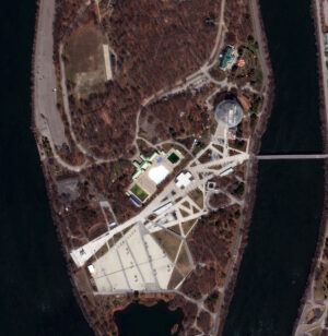 The Biosphere Environmental Museum, also known as the Montreal Biosphere, is a museum dedicated to the environment in Montreal, Quebec, Canada. It is housed in the former United States pavilion constructed for Expo 67 located within the grounds of Parc Jean-Drapeau on Saint Helen’s Island. The museum’s geodesic dome was designed by Buckminster Fuller. The Expo opened on April 27, 1967, and ran until Oct. 29, 1967. Upon entering the pavilion, visitors ascended a 135-foot escalator, reported to be the longest unsupported escalator in the world, to reach the exhibit platforms. The two uppermost platforms held “Destination: Moon,” an exhibit on NASA‘s space programs, where spacecraft were hung from the dome’s steel frame, including the Freedom 7, Gemini 7, and Apollo AS-202 capsules. On the mezzanine level, the “American Spirit” exhibit displayed a wide variety of artifacts, including American Indian crafts, folk art objects, guitars owned by famous musicians, a collection of dolls and an array of almost 300 hats representing a range of regions and occupations. Other attractions included a gallery of Hollywood memorabilia and “American Painting Now,” an exhibit of 22 large-scale works by contemporary American artists. A 300-seat theater screened A Time to Play, a multi-screen film by Art Kane showing American schoolchildren playing various playground games. After the Expo, the site continued to operate as Man and His World, an ongoing exhibition held every summer. Like most countries at the Expo, the United States donated its pavilion structure to the City of Montreal for use in the exhibition. The pavilion was renamed to Biosphere and opened in 1968 as an aviary and arboretum, featuring four suspended gardens and hundreds of birds. On May 20, 1976, the Biosphere was severely damaged in a fire. In August 1990, Environment Canada committed $17.5 million to turn Biosphere into an interactive museum showcasing and exploring the water ecosystems of the Great Lakes–Saint Lawrence River regions. The museum opened on June 6, 1995. The Biosphere changed its name in 2007 to become an environment museum. It offers interactive activities and presents exhibitions about the major environmental issues related to water, climate change, air, ecotechnologies, and sustainable development. The museum is housed in the former pavilion built by the United States for Expo 67. In the image above, we can see the metal lattice of the Biosphere Environmental Museum, and through this lattice we can also see the various buildings of the museum. The 30-cm WorldView Legion image was collected on April 14, 2025, and has custom processing and color balance applied by Apollo Mapping. (Satellite Imagery © 2026 Vantor)
In this monthly article, we travel the world to check out unique, fun and sometimes a bit weird 30-centimeter (cm) color imagery samples from the WorldView constellation. In April, we looked at the Caspian sea monster, officially known as a Lun-class Ekranoplan. For this edition of the 30-cm Color WorldView Image of the Month, we feature an image of the Biosphere Environmental Museum on Chemin du Tour de I’isle in Monreal, Quebec.
30-cm WorldView-3 (WV3) launched in late 2014, WorldView-4 (WV4) launched in late 2016 and then the first WorldView Legion satellites launched in 2024. Taken together, this is the most advanced satellite constellation the commercial marketplace has ever had access to. Here are a few of the features that really set these satellites apart from the competition:
- Improved Resolution
- Higher resolution means you can see more detail in WorldView imagery.
- Data collected at nadir will have 31-centimeter (cm) panchromatic, 1.24-meter (m) visible and near infrared, 3.7-m SWIR (WV3 only) and 30-m CAVIS (WV3 only) bands.
- Additional Spectral Bands
- If spectral analysis is part of your project, then no other satellite can match WorldView-3 and WorldView Legion with their 8 bands of visible and near-infrared data; and then 8 shortwave infrared bands (WV3 only) which are crucial for geological studies.
- Better Positional Accuracy
- With accuracies of 3.5-m CE90% or better (without ground control even!), the 30-cm WorldView constellation has no rivals for its enhanced positional accuracy.
- Daily Revisits
- With multiple WorldView-3 and WorldView Legion satellites orbiting our planet, daily revisits are available for most locations.
- WV4 is no longer collecting new imagery.
- Increased Collection Capacity
- WV3/4 feature 13.1-km swath widths (at nadir) with the ability to collect up to 680,000 square kilometers (sq km) of high-resolution data per day per satellite (though WV4 is dead now).
- WorldView Legion features six 30-cm satellites, significantly boosting the collection capacity of this leading high-resolution constellation.
If you are interested in WorldView-3, WorldView-4 and/or WorldView Legion imagery for your next project, please let us know by phone, 303-993-3863, or by email, sales@apollomapping.com.
You can also find more WV3 samples and technical information on our website here; WV4 samples and information can be found here; and then finally here is more information about WorldView Legion.
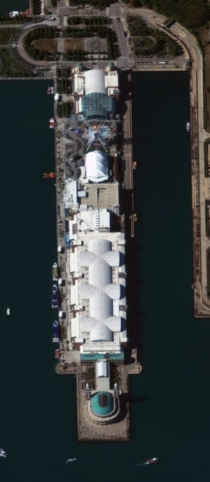
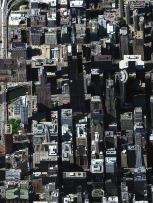
In our first images featured in this new monthly series, we have two bird’s eye view satellite images collected by WorldView-3 over Chicago, IL, USA on October 8, 2017. In these about 52-centimeter satellite images, you can see Chicago’s Navy Pier and then its tallest skyscraper, the Willis Tower. We hope you enjoy these high off-nadir satellite image samples! (Satellite Imagery © 2026 Vantor)
Welcome to our new monthly feature, The Bird’s Eye View! Each month, we’ll feature a new bird’s eye view satellite image from a select location around the globe; and for this month, we head to the home of the skyscraper, Chicago, Illinois, USA.
What Is Bird’s Eye View Satellite Imagery?
Well, that’s a good question we are happy to answer! When a satellite images the ground below it, there’s always some tilt to the camera as it looks down. This tilt is called off-nadir and is measured in degrees from 0; and so, it follows that 0° off-nadir means that the satellite is pointing directly down at the ground when it images, while a 90° off-nadir would mean that the satellite is pointing to the side and not even at the ground below it when it images. The vast majority of satellite imagery is collected with an off-nadir below 30°. However, in rare occasions, be it by a customer request, or to capture a natural disaster or other important event, a satellite can tilt and image in the range of 35° to 50° which we consider ideal for a high off-nadir imagery, also called bird’s eye view imagery. These bird’s eye view images lend a unique perspective to satellite imagery that is an expansive view of the landscape from the side. We hope you enjoy the bird’s eye view satellite imagery that we share in this article. And if you have any questions about this type of data or any of the imagery products we can help you with, send us an email at any time to sales@apollomapping.com!
If you are interested in additional bird’s eye view satellite images from this location, head over to our Reddit subgroup, BirdsEyeViewImagery, and become a member. We post high off-nadir satellite imagery every Friday in the BirdsEyeViewImagery subgroup.
 Imagine working with this colorful 50-cm WorldView-2 image with 8 bands? That is twice the spectral information for the same low cost. This 50-cm Maxar WorldView-2 image was collected over Central City, Pennsylvania on October 1, 2012.
Did you know that given recent pricing changes for high-resolution 8-band WorldView-2, WorldView-3 and WorldView Legion satellite imagery, you can order this additional spectral information for the same price as 4-band data?! Yep, you heard that right, so why wouldn’t you uplevel your spectral analysis for no additional cost?!
And additionally, you might not know that most 3-meter PlanetScope images can be delivered with either 4-bands or 8-bands for the same cost as well!
So, when it comes time to get started on a project that includes change detection, land use-land cover classification, vegetation analysis, and/or any other spectral analysis, why not use 8-band WorldView or PlanetScope data for the same cost?!
Send us an email at any time to uplevel your spectral analysis for no additional cost by using 8-band satellite imagery for your geospatial next project.

We love maps.
We love imagery.
We love work breaks.
We hope you like them as well!
Legendary golfer Rory McIlroy made his mark at the 2025 Masters.
McIlroy made birdie on the first playoff hole at the Masters to defeat Justin Rose after both finished at 11-under (277 total strokes) for 72 holes at Augusta National Golf Club. McIlroy earned his first green jacket in what many golf fans say was in “dramatic fashion.”
“This is my 17th time here, and I started to wonder if it would ever be my time,” McIlroy said afterward. “I’m just absolutely honored and thrilled, and so proud to be able to call myself a Masters champion … A moment like that makes all the years and all the close calls worth it.”
According to the PGA, Rose charged up the leaderboard with a final-round 66. McIlroy made bogey at the 72nd hole after pushing his approach shot into a greenside bunker, blasting to 5 feet and missing the par putt on the left side. McIlroy made amends with a wedge at 3 feet away on the first playoff hole, converting the birdie after Rose missed a 15-foot birdie try on the right side. McIlroy entered the final round at 12-under, two strokes clear of Bryson DeChambeau, and built a four-shot lead headed into the second nine Sunday but let the field back into the race with a double bogey at the par-5 13th hole.
McIlroy is now a five-time major winner, his previous major titles coming at the 2011 U.S. Open, 2012 PGA Championship, 2014 Open Championship and 2014 PGA Championship. This marked his 17th Masters appearance and his first time with the 54-hole lead at Augusta National since 2011.
We’ve covered the Masters numerous times in the past. You can view the impressive images and learn more about each year’s winner in our coverage here.
For this month’s Imagery Work Break, we feature a WorldView-2 50cm color image from April 13, 2025. It was taken during Round 4 play at the 2025 Masters golf tournament. In fact, we can see the gorgeous greens and the tan sand traps, along with numerous tiny dots of people scattered around the golf course to take in Round 4 action.
Have a great rest of your workday! 😊
(Image Courtesy: Vantor © 2026. Processed by Apollo Mapping for improved color accuracy and clarity.)
It wasn’t until very late in my 30s that I started to notice my body shedding its “invincibility.” It was my eyes that started to betray me, and I finally had to get glasses at 39. I still wasn’t getting sick very often – I went from 2011 to 2022 without ever being so ill that I couldn’t do anything, but even when I felt mildly under the weather, I struggled through it with a determined attitude. But shortly before that ’22 illness, I’d had a new-to-me and long-term bout of vertigo, something that was incapacitating and confusing for a matter of several weeks. It turned out that I’d had an ear infection, a wicked one, I guess. Maybe it was 2017 when I had a bout of some mysterious abdominal pains that eventually went away without diagnosis, and those resurfaced in a different form through cramping maybe in 2023 – they were just a couple of isolated incidents but were quite incapacitating in the moment. The mild aches and pains continued to come, and I’ve been fighting nagging hip pain for decades, something that comes every night and haunts my sleep. But still, through it all, I never felt like I was aging or picking up anything that could hold me down.
 ”Yep, I think you’re going to die, sorry.” (Image retrieved from here and comes courtesy of Antoni Shkraba Studio)
In May of 2024, I was hiking up in the White Mountains in New Hampshire, humidity having already settled over the mountains, but cold still in the air and ice still on the ground. The footing wasn’t great, so I wore my micro-spikes for that first hike up in Great Northeast, needing them for traction. As I neared the top, the snow and ice dissipated and I shed my spikes. On the horizon, I saw a small patch of ice I figured I could shimmy across, more because I didn’t want to bother putting the spikes on than that I thought the patch didn’t look suspect. As you might infer, it didn’t go as I’d hoped – I slipped on the ice and came down like dead weight on a fallen log with a bunch of broken branches, one of them punching me squarely in my chest. I was dazed, hurt in pride, but also with a throbbing soreness in my chest. I recall going to my rented cabin and showering, feeling the pain of the water hitting my chest. Over the remainder of the time I was up in the Whites, I watched the bruise grow, but it eventually disintegrated over the coming weeks.
Mid-January of this year, I was getting into my car when I opened my door right into my chest, squarely hitting the knot that was left behind from my fall nearly two years earlier. I distinctly remember thinking to myself, “That’s going to leave a bruise,” and then I went on with my activity and day. The soreness lingered, though, and shortly thereafter I started to have this numbness in my left bicep. That wasn’t unusual per se, as when I was a kid, I’d experienced this before, tracing it to a bundle of veins that were unartfully arranged in my upper arm. Again, I didn’t think much of this, just pushed on with life. Over time, though, I started to notice both more – not that either was getting worse, just that neither had gone away, and then I started to notice them both together, thus igniting the worry that something worse was the cause. After a month passed, I decided to schedule an appointment for urgent care (my primary-care physician had just retired and my transfer of care appointment was still months away, so I was in healthcare limbo), and that didn’t yield much as they were limited by the services they could provide. They did a wide-ranging blood test, though, and the only thing that came back was something indicative of inflammation, suggesting that it was the reaggravation of my chest injury. That physician said I should follow up with my PCP in a week if things didn’t improve.
As stated, I have no PCP currently, so I booked an appointment with one of his colleagues because he was booked up for weeks. She didn’t turn up anything in her examination and suggested an MRI, but due to some miscommunication and possible coding errors, this took longer to schedule, not to mention that the facility was backed up as it was anyway. Eventually, I did get in (a Monday in late-ish March), and I won’t go into that whole process (which was uncomfortable because of how I had to position my body for an ungodly long stretch), but as it wrapped up, they mentioned that it may take five business days to get the results, and that after the tech read them, it would be posted to my patient portal and then my physician would follow up after that. I figured five days was a worst-case scenario, but a full four days later at the time of writing, and on the cusp of a weekend, I guess they were serious – I hope the injury isn’t, because this kind of delay is ridiculous. Hire another person to read results, jeez!
Anyway, I’ve got myself convinced this is quite serious and a death sentence is forthcoming. Not exactly positive thinking, I know, but I’m also not stressed about it – I’m just settling my estate and my affairs in my mind in an overly practical way. We all have to go sometime, but this would be one of the stupidest ways to do it, possibly. If I make it through this, I’ve only got further decline ahead of me, that much is guaranteed. I do feel that I have a lot of life to live and a lot of things I’d like to do, so I hope I’m given a reprieve, and while I’m not religious in any capacity, I think this would be a cruel joke for God to play if he exists and death is around the corner.
I recall sitting in a philosophy class in grad school once and the professor making a comment about how people always react to bad news: “Why is this happening to me?” He responded, “Why shouldn’t it? Bad stuff happens to everyone, and nobody escapes it, so why would you be surprised when it finally shows up on your door?” At the moment that gave me some peace. Now, as I think about the end of the line more than is healthy, not so much. I’d like to say I’ve had a good run, but that would be an exaggeration. Give me a few more years and I’ll make it so, that way when the reaper comes calling, I’ll be in a more satisfied state and accepting of his summons.
Marco Esquandoles
Walking Dead