
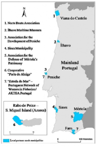
 This graphic shows the seven focus sites for the Celebration of Coastal Culture study. Each agency was integral in the collection of data and establishing local contacts.
Researchers at universities in Portugal recently completed a study that examined the role of culture on the coasts of Portugal. Their goal was to document maritime cultural heritage in the many fishing ports that dot the country’s coastline. Through interviews and the use of GPS data collection to illustrate site maps, Souto, Gomes and Carvalho set out to paint a picture of Portugal’s rich culture. The researchers considered multi-functionality when examining the social, economic and environmental development of the region. Recent focus on regulation of primary sector areas, such as food production, and the social exclusion of rural producers from the larger regulatory picture, sparked the authors to tell the story of those who still follow traditional methods of living.
Their research coincided with a European Economic Area grant to fund the Celebration of Coastal Culture project which included seven Portuguese coastal communities. The project was promoted and managed by an insurance company established in the 1940s to specifically support the fishing industry. The seven communities were selected from numerous applicants to show the cultural significance of the fishing trade and to help assure its continuity in the next generation of Portuguese. Each of these communities already featured the local trade through museums, fishing boat preservationist societies, women in fisheries groups and more.
 A cartographic representation of the GPS points collected by urban structures, geophysical features, etc.
The main goal of the study was to identify, catalog and make permanently available information on local and regional maritime-fluvial cultural heritage. The researchers also wanted to develop and implement new strategies for the recognition of cultural heritages along the coastal communities. Their collection of GPS/GIS data was grouped into various categories: geophysical data (e.g. rivers, topography); urban structures of dwelling and workplaces; “emotional” topological points (e.g. interview locations); landscape/architectural monuments (e.g. churches); and places deemed important to the industry (e.g. ports).
The use of GIS allowed for effective visualization of the compiled data which was in turn beneficial to building a case for the recognition of the historic and indigenous practices of these unique fishing communities. The researchers hope that the establishment of a website boasting the heritage of the study sites and participants will lead to outside involvement to document and sustain the practices and issues associated with the coastal communities. The authors did consider if tourism would help sustain the communities but concluded that more research was needed to study the potential environmental and cultural impacts. Ultimately, the study provided a foundation for participant action research so that outside investigators can work in tandem with locals to increase the vitality and quality of life for those who reside in the region.
Justin Harmon
Staff Writer

Leave a Reply