

- Are you ready for your monthly does of all-things technology? If so, please do read on!
Chewing this gum could help you fight cancer.
A new planet-searching telescope clears last major launch hurdle.
First material with quantum properties at room temperature.
Bacteria can clean radioactive uranium from groundwater.
Our diets can influence our evolution as well.
Wool could help us regrow human bones.
Nature can process bioplastics in multiple ways.
These tiny robots hunt bacteria.
Wow, a soft tissue sample some 450 million years old!
New catalyst to break plant waste down into valuable byproducts.
Microbial life could survive on the Moon.
This tiny satellite could observe some of the oldest signals in the Universe.
A lower-energy method to print a crucial metal alloy for extreme environments.
Ultra-thin diamond layers can transmit electricity.
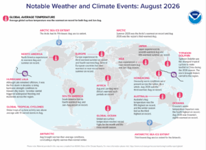 The summer of 2026 was the Arctic’s warmest on record and August 2026 was the region’s third warmest August. The Antarctic saw its third lowest August ice extent in 2026. In Africa, August and June-August were Africa’s warmest such periods on record. North America experienced its warmest August and summer on record. Hurricane Lala remained offshore, but was the first storm in decades to bring hurricane-strength conditions to Hawaii’s Big Island. Torrential rainfall triggered widespread flooding and mudslides across the region. Global tropical cyclone activity was above average with 19 named storms in August. Typhoon Dolphin was the strongest tropical cyclone to make landfall in China during the 2026 season. The storm brought historic rainfall to the region. (Image Credit: NOAA Global Climate Report)
- The Global Climate Change Report for August 2026 has been released by NOAA’s National Centers for Environmental Information and reveals further proof that global climate change remains a concern. In August 2026, the global surface temperature was 1.32°C (2.38°F) above the 20th Century average – the warmest August in the 1850 to 2026 record, eclipsing the previous tied records set in 2023 and 2024 by 0.08°C (0.14°F). It marked the 48th consecutive August with global temperatures above the 20th Century average (the last below-average August occurred in 1978). All 10 of the warmest Augusts on record have occurred since 2016, with the last four years (2023–2026) representing the four warmest. Notably, August 2026 was the fourth-consecutive August with a temperature departure exceeding +1.0°C (+1.8°F), ranking as the sixth-highest temperature departure for any month in the 2,120-month record. Global oceans set an all-time high temperature departure for any month on record at 1.08°C (1.94°F) above average. Driven by record-high surface temperatures across the central and eastern tropical Pacific Ocean zone, alongside record warmth across parts of the Arctic, Atlantic, Indian, and Southern oceans, the global ocean surface temperature surpassed the previous August 2023 record by 0.06°C (0.11°F); and the previous tied all-time monthly high set in January and February 2024 by 0.05°C (0.09°F). August 2026 marked the third consecutive month of record-breaking global ocean heat and only the second time an August ocean temperature departure surpassed 1.0°C (1.8°F).
- Long before today’s state lines, cities and highways appeared on maps, Indigenous people lived across the lands that later became the United States. This Indigenous Peoples’ Day, Americans can use interactive maps and Geographic Information System, or GIS, to learn more about tribal lands, Indigenous geography and the Native communities that remain an important part of the country today. Indigenous Peoples’ Day is observed on the second Monday in October and recognizes the histories, cultures and contributions of Native American and Indigenous people. Maps offer one way to explore that history, but they also show that Indigenous America isn’t simply part of the nation’s past. Tribal nations exist throughout the United States still today, and federal agencies and tribes use sophisticated GIS technology to map and manage land and natural and cultural resources. The U.S. Bureau of Indian Affairs’ Branch of Geospatial Support maintains public GIS datasets and mapping tools related to Indian Country. Among the resources is the BIA Tract Viewer, which displays mapped tribal, individually allotted and jointly managed tracts and parcels associated with tribal land area codes. The agency’s GIS program has a practical purpose beyond creating maps. The BIA says it provides GIS software, training and technical assistance to federally recognized tribes and Indian Affairs offices to help manage cultural and natural resources. Tribes use GIS for land management and analysis involving forests, wildfires, irrigation, flood plains, oil and gas resources and other issues. The U.S. Census Bureau provides another nationwide source of Indigenous geographic information. Its cartographic boundary files include downloadable national GIS data for American Indian and Alaska Native areas and Hawaiian homelands. The Census Bureau also provides geographic files for American Indian tribal subdivisions, Alaska Native Regional Corporations, tribal census tracts and tribal block groups. The Census Bureau’s TIGER/Line program provides detailed geographic datasets that can be downloaded and used with GIS software. Available American Indian geographic datasets include American Indian, Alaska Native and Native Hawaiian areas; tribal subdivisions; Alaska Native Regional Corporations; tribal block groups; and tribal census tracts. The connection between GIS and Indigenous Peoples’ Day isn’t limited to looking at historical maps. GIS also is used by tribal governments today. The Bureau of Indian Affairs provides ArcGIS and other geospatial resources to participating federally recognized tribal governments. According to the agency, tribes use GIS to map and manage cultural and natural resources and contribute to datasets benefiting Indian Country. The technology can be used for everything from forestry and real estate to natural-resource management and land surveying. The BIA also is working on a parcel-mapping project designed to improve how geographic information about tribal lands is collected and shared.
Brock Adam McCarty
Map Wizard
(720) 470-7988
brock@apollomapping.com
This entry was posted in The Geospatial Times and tagged News Snippets, The Geospatial Times Bookmark the permalink.


 Copyright © 2025 All Rights Reserved -
Leave a Reply