
- Technology is cool! Don’t’ think so? Read on and I bet you will agree then 😊
Low-cost catalyst to produce hydrogen gas invented.
Bigger veggies through gene research.
Innovative method to re-use waste plastics.
New technique to detect life on other planets.
These solar cells are 100% recyclable in water.
More efficient mobile displays could be on the way.
This blanket cleans water with the help of sunlight.
A safe way to clean up microplastics.
This new carbon-negative material could revolutionize construction.
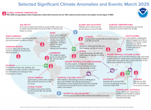 In March 2025, more than 20 people died and tens of thousands of homes were damaged by heavy rain, flooding and landslides in Ecuador. Large wildfires, including the reported biggest forest fire in South Korea’s history, led to more than two dozen fatalities and destroyed historic structures. Tropical Cyclone Alfred brought riverine and flash flooding, large-scale power outages and property damage to southeastern Queensland. Hawaii recorded the third warmest March and warmest January-March on record for the region. The Antarctic Sea ice extent for March ranked as the fourth smallest on record and in the Arctic, the sea ice extent was the lowest on record for March. (Image Credit: NOAA Global Climate Report)
- The NOAA Global Climate Change Report for March 2025 has been released by the National Centers for Environmental Information and it reveals further proof that global climate change remains a concern. March 2025 was the third warmest March on record for the globe in NOAA’s 176-year record. The March global surface temperature was 1.31°C (2.36°F) above the 20th Century average of 12.7°C (54.9°F). This is 0.03°C (0.05°F) less than the record-warm March of last year. March 2025 marked the 49th consecutive March with global temperatures, at least nominally, above the 20th Century average. Approximately 3.9% of the global land surface was affected by record-warm conditions in March. Global land-only March temperatures ranked second warmest on record at 2.24°C (4.03°F) above average. Ocean-only temperatures also ranked second warmest on record for March at 0.90°C (1.62°F) above average. Sea surface temperatures were record warm across a large area of the western tropical Pacific, parts of mid-latitude central Pacific, as well as small areas in the southeast Pacific, the southwest Atlantic, and small parts of the Southern Ocean.
- Farmers markets get underway in April and May across the USA. They’re the perfect place for farmers and growers to sell their products to local consumers, whether it’s honey from their own bees, fresh cut flowers from their own properties, or veggies and fruits from their personal gardens. Some vendors bake an array of goodies while others whip up batches of salsa, jams and jellies. There are states that use GIS for a variety of purposes related to farmers markets. The South Carolina Department of Public Health uses GIS to map out farmers markets and roadside markets to highlight where community members can find fresh fruits and vegetables to help promote a healthy diet. The state of Iowa uses GIS to create a map of farmers markets that pulls a variety of data from the Iowa Department of Agriculture and Land Stewardship data directory. The state of Massachusetts relies on the Farmer’s Markets GIS that pulls data from their farmer’s markets database that connects local farmers with shoppers. For more than two decades, the Sustainable Agriculture Network has set out to improve the lives and production practices of more than 1.2 million farmers around the world. The SAN Intelligence Hub (iHub) is an information management solution specifically designed for agricultural operations and supply chains to simplify decision making process and add value to the Farms for the Future program’s participants. Using GIS technology, iHub helps identify the best practices that farmers need help with, and then guides that support to the right farmer audiences. The system includes many features such as customized baseline assessments and compliance checklists, performance dashboards, geographic location and maps of farms, group management, and charts and reports that facilitate the overview and real time monitoring of farms and supply chains.
Brock Adam McCarty
Map Wizard
(720) 470-7988
brock@apollomapping.com
This entry was posted in The Geospatial Times and tagged apollo news, News Snippets, The Geospatial Times Bookmark the permalink.

Leave a Reply